History, current state, and prospects for studying the Lower Cretaceous reservoirs in the Tersko-Sunzhenskaya oil and gas region
- Ph.D. Associate Professor Millionshchikov Grozny State Oil Technical University ▪ Orcid
Abstract
Cretaceous deposits represent one of the most important stratigraphic intervals characterized by the development of hydrocarbon reservoir rocks. Given the growing demand for energy resources and the depletion of proven reserves, further study into the Lower Cretaceous deposits of the Chechen Republic is a crucial task for the region and the entire country aiming to ensure its energy security. For the Chechen Republic, which has a significant number of historically explored oil fields, the synthesis and reinterpretation of logging data will open up new opportunities for the development of deep horizons. More than ten fields associated with the Lower Cretaceous deposits are discovered in the Tersko-Sunzhenskaya oil and gas region (TSOGR). The thick oil and gas bearing terrigenous sequence formed in the coastal zone of the marine basin in the East Caucasian foredeep is one of the most important areas for hydrocarbon production in the Chechen Republic. We provide a brief summary of the exploration status of the Lower Cretaceous rocks in the Eastern Ciscaucasia since the early period. We present information on the geological and geophysical exploration status and oil and gas potential of the Lower Cretaceous in the TSOGR. In addition, we generalized data on the distribution, formation, and development features of the Lower Cretaceous reservoir rocks and associated oil and gas reserves to improve understanding of the prospects for further development of the Lower Cretaceous deposits in the Chechen Republic – one of the oldest industrially developed Cretaceous deposits.
None
Introduction
Global practice in oil and gas exploration methods showed that most hydrocarbon accumulations formed during the Mesozoic, with approximately 60 % of oil and gas fields associated with deep-lying Cretaceous reservoir rocks [1-3]. The studied Albian-Aptian deposits of the Cretaceous initially formed under marine conditions favourable for the accumulation of organic matter – the initial substrate for subsequent hydrocarbon generation. During diagenesis and catagenesis, these predominantly terrigenous (sand-silt) sequences acquired good reservoir properties (due to the development of pore and fracture space), which later ensured efficient hydrocarbon accumulation. Geological features and tectonic processes created numerous anticlinal traps of structural and combined structural-tectonic types (fault- and thrust-screened), thereby completing the formation of the petroleum system [4-6].
Analysis of the age-based distribution of deep-lying oils, conducted in [7-9], showed that the Paleozoic oils predominate in the studied sample, accounting for more than 53 % of the total volume. Approximately one-third of deep-lying oils is concentrated in the Mesozoic deposits, while the Cenozoic deposits account for roughly 14 % [10, 11]. In the Russian Federation, the concentration of hydrocarbon accumulations at great depths is mainly characteristic of the West Siberian and North Caucasian oil and gas basins – 33 and 35 deep-lying oil fields, respectively [12]. A significant portion of these accumulations is associated with the Cretaceous rocks, both in Western Siberia and in the Eastern Ciscaucasia. In the Chechen Republic, more than half of oil production comes from accumulations in carbonate and terrigenous rocks of the Upper and Lower Cretaceous. Since 2011, deposits from the Lower Cretaceous formations are under commercial development at the following fields: Starogroznenskoye, Oktyabrskoye, Bragunskoye, Goryacheistochnenskoye, Eldarovskoye, Khayan-Kortovskoye, and Pravoberezhnoye.
Significant contributions to the geological understanding of the Eastern Ciscaucasia were made by the works of I.O.Brod, I.A.Konyukhov, A.A.Khanin, M.S.Burshtar, V.P.Belousov, P.P.Zabarinsky, I.M.Krisyuk, B.K.Lotiev, Yu.A.Sterlenko, V.I.Konovalov, V.A.Stanulis, K.I.Smolyaninova, A.V.Merkulov, N.E.Merkulov, V.N.Maydebor, V.D.Talalaev, M.S.Bagov, A.S.Sakharov, V.M.Vasiliev, and A.E.Salamatin, among many other researchers. The subject of study in this work is the Lower Cretaceous Albian-Aptian deposits of the Tersko-Sunzhenskaya oil and gas region (TSOGR). The focus is primarily on the geological, geophysical, and hydrogeological data directly relevant to the study of the Lower Cretaceous.
Thus, the Lower Cretaceous complex of the TSOGR, despite its long exploitation history, cannot be considered geologically depleted. The main unresolved issue lies in the lack of effective tools for identifying local accumulations screened by impermeable rocks and hydrodynamic settings within generally depleted fields.
The objective of this work is to quantitatively assess the resource potential of such “missed” targets in the Albian-Aptian deposits of the TSOGR. This is based on a historical analysis of the geological and geophysical exploration status of the Lower Cretaceous deposits, comprehensive reprocessing of the historical archive of geophysical and petrophysical data, and the development of technical solutions for their further exploration. To achieve this objective, the following tasks were addressed: critical analysis and systematization of previous research results; development and verification of a petrophysical model for identifying low-permeability reservoirs; application of the model to process well data sets and map prospective intervals; formulation of a justified plan for geotechnical operations.
Materials and methods
Stages of studying Lower Cretaceous rocks
The beginning of geological research into the Lower Cretaceous in the Caucasus region can be traced back to the publication of works by the explorer and scientist I.V.Mushketov in 1886. In 1897, the work of geologist and paleontologist N.M.Karakash provided a lithological description and faunal justification for distinguishing individual stages and zones [13]. Geological structure and stratigraphy of the Cretaceous across the entire Caucasus, particularly stratigraphy of the Lower Cretaceous deposits*, were extensively studied later by such scientists as N.A.Kudryavtsev, I.G.Kuznetsov, V.P.Rengarten, and T.A.Mordvilko [14, 15]. From 1914 to 1939, A.N.Ryabinin (1914), B.A.Alferov (1925), L.A.Grechishkin (1932), and V.M.Pats (1939) studied the Lower Cretaceous directly in the Grozny region, southeast of the Assa and Kambileevka rivers. Researchers V.A.Tilyupo, V.I.Pats, N.S.Zolotitsky, V.A.Stanulis, and others collected a large body of factual data on the Lower Cretaceous section in the highland areas of the Grozny region. There were relatively few dedicated studies focusing on the lithology and petrography of the Lower Cretaceous during this early research period. Prior to 1950, these investigations were conducted in a non-systematic manner [16, 17].
The works by V.M.Pats, M.G.Barkovskaya, and others, who conducted research in Chechen-Ingushetia, contain some data on the lithology and petrography of the Lower Cretaceous [18]. However, as early as 1951, K.I.Smolyaninova processed the material collected by geologist V.A.Stanulis on the Lower Cretaceous in the Netkhoy river basin (Netkhoy, Erbel, Uchikhoy), with the results compiled into a special report.
Research carried out by the North Caucasian Oil Expedition of the USSR Academy of Sciences (I.A.Konyukhov, V.V.Olenin, and others) marked the beginning of detailed and systematic study of the Mesozoic in Dagestan and the Eastern Ciscaucasia. The authors extensively used the results of petrographic studies to support their main conclusions [19, 20]. In subsequent years, due to increased interest in these deposits amidst the forecasting of petroleum potential in the Cretaceous formations of the Eastern Ciscaucasia, the Mesozoic-related studies expanded significantly. Many geological institutions engaged in their investigation. Over several years, the stratigraphy of the Lower Cretaceous in North Ossetia and the Grozny region was studied by researchers from the Grozny Oil Institute (I.M.Krisyuk) and the Groznefterazvedka Trust (L.A.Kolykhalova and V.A.Stanulis). The processed ammonite (V.P.Rengarten) and pelecypod (T.A.Mordvilko) fauna significantly refined the stratigraphy of the Lower Cretaceous in these areas.
In the early 1950s, two reference wells – Artesian and Dzhanay – were drilled in the Stavropol Krai region, in the area of the Zaterechnaya Plain, along with a deep well near the village of Promyslovoye. Core data from these wells provided virtually the first insights into the lithological structure and occurrence patterns of the Lower Cretaceous in the study area. Petrographer G.E.Labkovskaya conducted petrographic studies of core material from the Artesian 1 reference well. The entire section penetrated by the well was described in detail, including the Lower Cretaceous sequence. Based on mineralogical and lithological characteristics, three series were identified within the section of these deposits: the two upper series are represented by a complex of sand-silt rocks and clays, while the third is predominantly composed of carbonate rocks. In 1954, the first results of petrographic study of the Lower Cretaceous were obtained by petrographer K.I.Smolyaninova. Later on, between 1956 and 1963, a more extensive dataset on the Lower Cretaceous was compiled. The report provides a detailed lithological and petrographic description for all marker formations of the Lower Cretaceous, compares the equivalent deposits in the Artesian, Dzhanay, and Promyslovoye areas, and concludes that formation XIII more likely belongs to the Aptian of the Lower Cretaceous rather than to the Jurassic [21].
Around the same period, from 1955 to 1957, Senior Researcher at GrozNII R.G.Dmitrieva conducted a detailed study of the Jurassic in the Zaterechnaya Plain, as well as the rocks of formation XIII. She provided a comprehensive description of these deposits, along with conclusions regarding sedimentation conditions and sources of terrigenous material supply for these deposits. The attribution of formation XIII to the Upper Jurassic was proven. From 1957 to 1959, R.G.Dmitrieva continued studying rocks from the Lower Cretaceous of the Zaterechnaya Plain. As a result, she gave a detailed description for both the clayey rocks of the Lower Cretaceous and the terrigenous rocks within these deposits.
Senior researcher at GrozNII A.E. Salamatin, who also studied the geology of the Lower Cretaceous in the Zaterechnaya Plain and adjacent areas, compiled numerous facies maps for each stage of the Lower Cretaceous, isopach maps, and addressed the key issues of paleogeography for these deposits across the extensive area of the Eastern Ciscaucasia [22].
Drilling and petroleum potential
Drilling into the Lower Cretaceous deposits of the TSOGR for development purposes began in 1954 at the Karabulak-Achaluki field. Well 16 penetrated the Barremian but yielded no positive results when testing the Lower Cretaceous complex. However, an unexpected oil gusher was obtained from the Upper Cretaceous deposits in the same well. This caused further exploration of the Lower Cretaceous in the zone of foreland anticlinal folds to be temporarily downgraded in priority. The first commercial oil from the Lower Cretaceous was obtained only six years later, in 1960, at the same Karabulak-Achaluki field, from well 39.
In 1958-1959 three wells were drilled in the Argun River area, penetrating the Lower Cretaceous sequence. Valuable factual data were collected from these wells, with considerable attention paid to the geological and petrographic study of the Mesozoic deposits – particularly the Lower Cretaceous ones. Special interest in this complex stems from its proven commercial petroleum potential, coupled with insufficient knowledge of its stratigraphy and lithology.
The first field geophysical studies of the Albian-Aptian of the Lower Cretaceous in the study area were carried out as early as 1955, also at the Karabulak-Achaluki field. The mandatory suite of geophysical investigations for these deposits was approved in 1968 and included standard logging, lateral logging sounding (LLS), caliper logging (CL), gamma-ray logging (GL), and neutron gamma-ray logging (NGL).
In subsequent years the natural radioactivity of the Mesozoic sand-silt-clay rocks and their fractions was first studied for the Albian-Aptian of the Chechen Republic and the Republic of Ingushetia. It was found that radioactivity of the sand, siltstone, and clay fractions amounts to 2, 8.5, and 9 pg-eq Ra/g respectively. Acoustic logging (AL) was performed in single wells as an additional method for assessing rock porosity.
By the early 1980s the Lower Cretaceous deposits were studied by drilling in many areas of the North-Eastern Caucasus and were fully penetrated by wells in mountainous and foothill regions at the Zolskaya, Baksanskaya, Argudanskaya, Datykhskaya, Argunskaya, Elistanzhinskaya, and Benoyskaya prospects. Within the Sunzhenskaya and Terskaya anticlinal zones, the deposits were fully penetrated at the Zamankulskaya, Karabulak-Achalukskaya, Malgobek-Voznesenskaya, Aliyurtovskaya, and Khayan-Kortovskaya prospects; partially penetrated at the Nazrano-Yandyrskaya, Sernovodskaya, Kharbizhinskaya, Arak-Dalatareckaya, Akhlovskaya, Eldarovskaya, and Starogroznenskaya prospects; and fully penetrated in the Priterechnaya zone at the Galyugaevskaya and Burunnaya prospects.
As a result of the conducted prospecting and exploration activities, the petroleum potential of the Valanginian, Barremian, and Albian-Aptian deposits was determined in the Lower Cretaceous section. Commercial reserves of oil and gas from the Lower Cretaceous were placed on the state balance sheet for the following fields: Karabulak-Achaluki, Malgobek-Voznesenskoye, Khayan-Kort, Starogroznenskoye, Oktyabrskoye, Bragunskoye, Akhlovo, Eldarovo, and Yastrebinoye. A significant part of the East Caucasian foredeep is occupied by an epicontinental marine basin. Sediment accumulation occurring in this basin led to the formation of clayey, sand-silt-clayey, and carbonate rocks. These rocks are precisely involved in the development of a thick sedimentary terrigenous-carbonate formation that constitutes the Lower Cretaceous deposits of the TSOGR [23].
According to A.E.Salamatin [22], the Lower Cretaceous incorporates the Valanginian-Hauterivian, Barremian, Aptian, and Albian stages. The main oil and gas bearing horizon is the terrigenous complex of the Albian and Aptian, occurring at depths from 2300 to 6500 m. The average thickness of the Lower Cretaceous as a whole varies from 700 to 1600 m. For the convenience of dismembering and correlation of the studied target, a median normal geological-geophysical section was compiled (Fig.1), with some refinements by the article’s author. Six sand-silt members are identified in it – I, II, III, IV, V1, and V2. The main discovered oil and gas reserves in the Lower Cretaceous are concentrated in the Aptian deposits, which include five of the aforementioned six members – II, III, IV, V1, and V2.
In 1977, K.I.Smolyaninova, in one of her works devoted to the study of deep-lying reservoirs in the area under investigation, presented the results of petrographic and lithological studies of the rocks. She showed that the main “container” of the pay Albian-Aptian formations occurring deeper than 3000 m is primary intergranular porosity, supplemented by leaching porosity and fracturing. Based on the assessment of the permeability and porosity properties of the Aptian rocks, it can be concluded that the studied reservoirs belong to the fracture-pore type [24].
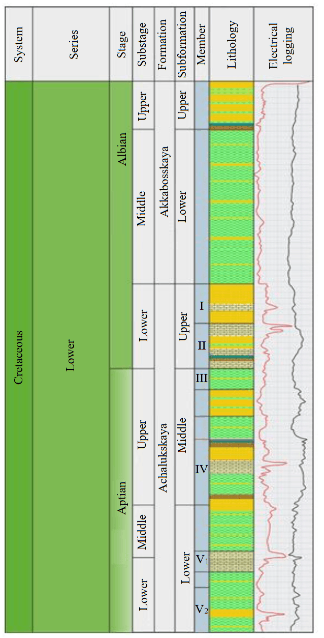
Fig.1. Summary section of the Albian-Aptian deposits of the TSOGR
Laboratory core studies were mostly conducted at the Special Design and Technology Bureau of Field Geophysics, the North Caucasian State Research and Design Institute of the Oil Industry, and the Grozny Oil Institute. On selected core samples, a special analysis to study the elemental composition was carried out at the All-Union Research Institute of Nuclear Geophysics and Geochemistry in Moscow. The mineralisation of pore waters was studied at Rostov State University, and petrographic descriptions of thin sections were performed by the thematic expedition of the Grozneft Association. In total, there are documented analysis data for more than 1200 core samples from over 60 wells across nine Lower Cretaceous fields of the TSOGR.
Since 1980, the following suite of field geophysical investigations is applied to study the Albian-Aptian – standard logging, lateral logging (LL), induction logging (IL), combined lateral and induction logging (LIL), lateral logging sounding (LLS), acoustic logging (AL), gamma-ray logging (GL), neutron gamma-ray logging (NGL), caliper logging (CL).
The historical analysis carried out allows us to draw a conclusion that is fundamentally important for the present study. By the early 1990s, an exceptionally large and detailed array of primary geological and geophysical data was accumulated in the TSOGR. However, the methodological toolkit for interpreting this data was limited by the technologies of the time and focused on identifying large, structurally controlled accumulations in high-permeability reservoirs. Complexly structured silt-clay members, which constitute a significant part of the section, often remained a blind spot. Thus, today we are faced with the need to fully digitise and reinterpret the accumulated material using advanced techniques and modern digital technologies – as an additional argument in favour of previously proposed recommendations for further development. This constitutes the subject of the subsequent discussion.
Current state and prospects
The majority of the TSOGR lies within the Chechen Republic. In addition to the Chechen Republic, this oil and gas-bearing region extends into part of the Republic of Ingushetia and covers minor portions of several other neighbouring regions. The Chechen Republic is rightfully considered one of the oldest oil-producing regions in the country and the world. In October 2023, the region’s oil industry marked the 130th anniversary of initiating the commercial development of hydrocarbon deposits.
Since the start of development of the Lower Cretaceous deposits (1983), about 34 accumulations were discovered in the Mesozoic. Currently, 15 accumulations are under development across several fields in the Chechen Republic, and six in Ingushetia (Fig.2). After the collapse of the USSR, geological exploration activities in the region were almost suspended from 1992 to 2008. Comprehensive geological exploration was resumed only in 2009, including seismic exploration and prospecting and exploratory drilling. From 2009 to 2022, the following were implemented in the Chechen Republic: 2D seismic survey on twelve and 3D seismic survey on three licensed areas of Grozneftegaz JSC (a subsidiary of NK Rosneft PJSC), 2D seismic surveys were performed on seven licence blocks of Chechenneftekhimprom JSC. As a result of data processing and interpretation, six structures were identified, one exploratory and five prospecting wells were drilled [25, 26].
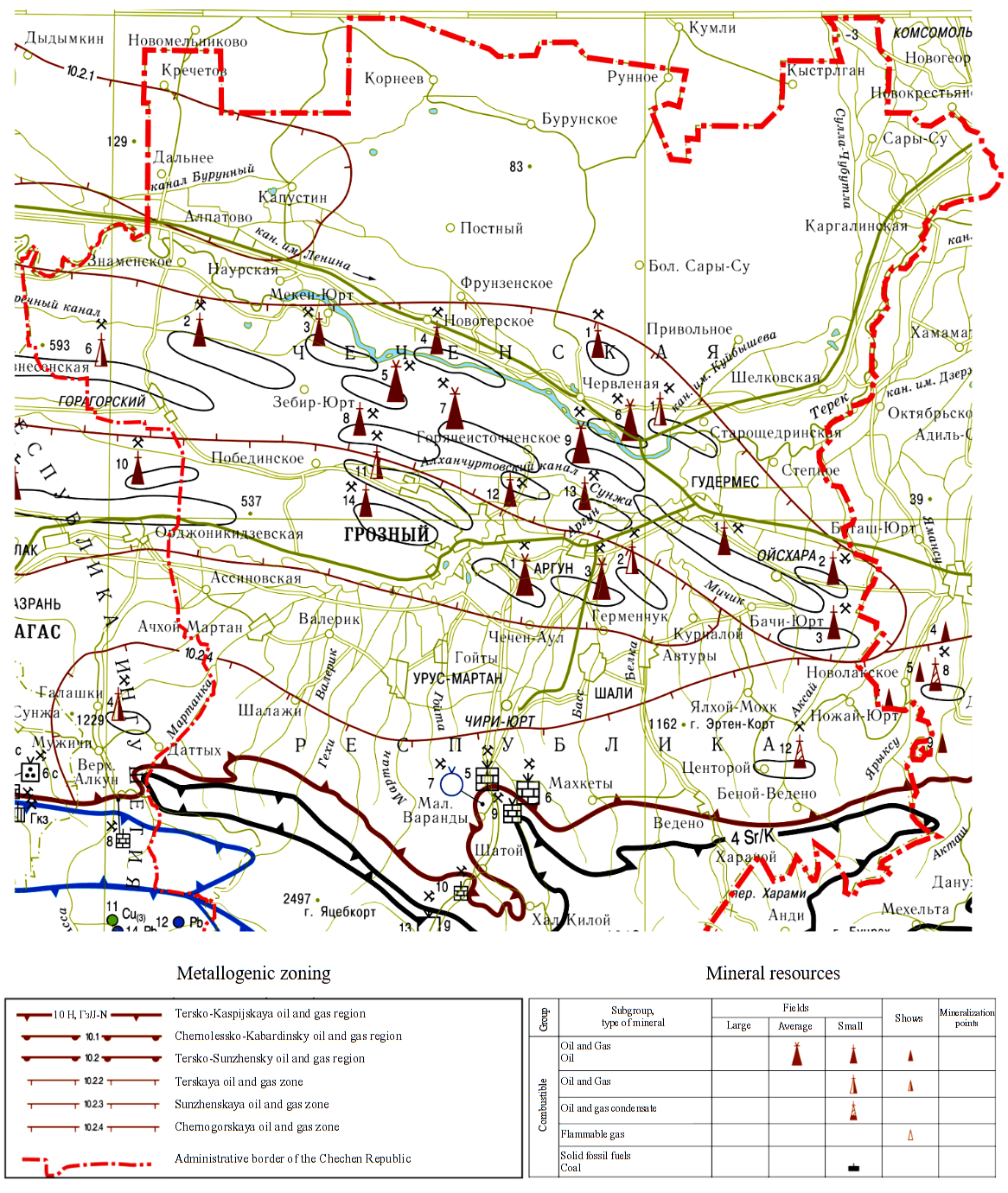
Fig.2. A fragment of the map of mineral resources of the Russian Federation (Scythian series), revised by the author
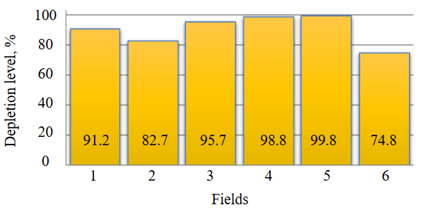
Fig.3. Depletion of the Lower Cretaceous fields in the TSOGR (Chechen Republic)
1 – Bragunskoye; 2 – Oktyabrskoye; 3 – Pravoberezhnoye; 4 – Starogroznenskoye; 5 – Khayan-Kortskoye; 6 – Eldarovskoye
In 2003 I.G.Shnurman conducted a comprehensive analysis of available core data, based on which petrophysical characteristics of the Albian-Aptian deposits were studied and updated [27]. From 2009 to 2012, as part of research into modern methods and technologies for processing and interpreting well logging data (WLD), a comprehensive analysis of results was carried out. An additional set of core data studies was performed to better substantiate the requirements for the interpretation level of WLD in the studied geological section. A set of petrophysical models in terrigenous rocks of the studied section was substantiated, and a methodology for interpreting WLD in the Lower Cretaceous accumulations of the TSOGR was proposed [28-30]. To date, the vast majority of drained oil and gas accumulations in the Chechen Republic are in the final stage of development, with the degree of oil reserve depletion exceeding 98 %. As of 01.01.2025, the state balance of the Russian Federation for the Chechen Republic includes the following oil reserves: category A + B1 (oil from developed accumulations for which production is ongoing or planned) – 9805 thousand t; category B2 (oil from undrilled evaluated accumulations of fields brought into development, for which production is planned) – 1779 thousand t.
The bar chart (Fig.3) graphically presents data on the depletion level of individual Lower Cretaceous accumulation across a number of key fields in the study area. As of January 2025, the degree of exploration of initial forecasted total oil resources amounted to 80.16 %, while the depletion level of drilled reserves, as previously noted, exceeds 98 % [31]. This situation renders traditional approaches based on searching for large structures ineffective and necessitates a transition to a model focused on identifying residual and missed reserves in heterogeneous reservoirs within already explored areas.
Despite the fact that the depletion level of the Cretaceous complex within the TSOGR reaches 98 %, this complex – particularly its Lower Cretaceous part – remains insufficiently drilled and tested. One of the priority directions remains the retesting of the Lower Cretaceous deposits within the geological exploration programme, following a thorough analysis of available geological and geophysical stock materials, based on the results of their digitisation, processing, and interpretation.
It should be noted that the author’s analysis of available geological and geophysical materials was carried out only within the boundaries of already identified and developed Lower Cretaceous fields in the Chechen Republic. In these fields, there may be oil accumulations in the Cretaceous deposits that were missed during initial drilling, as well as fields holding oil classified as category C2 reserves or C3 resources on the balance sheet. For this purpose, materials from nine fields within the operational area of Grozneftegaz JSC were analysed. The methodological background for addressing the set task was TABS technique for interpreting WLD in terrigenous silt-clay rocks, adapted by the author for the conditions of the Albian-Aptian deposits in the TSOGR and implemented in the Gintel software package. The subject of the study includes petrophysical, permeability, and porosity properties of the Albian-Aptian terrigenous reservoirs, as well as spatial distribution of potentially pay intervals, identified based on reinterpretation results.
Study algorithm
To localise missed accumulations and substantiate recommendations for additional exploration, a technique for identifying sand-silt bodies potentially containing residual hydrocarbon reserves was used. The technique was developed by the author through adapting a system of petrophysical models and in-depth interpretation of WLD from the TABS Gintel system for the conditions of Albian-Aptian deposits in the TSOGR. The technique includes the following sequence of operations: loading and normalisation of multi-format WLD and core data into a unified database; estimation of derived parameters based on a three-component model. The model allows decomposing logging curves to estimate the volumetric content of sand fraction (Кsand), silt fraction (Кsilt), clay fraction (Кclay), effective porosity (Kef.por), water saturation coefficient (Kw), and predicted permeability (Kperm).
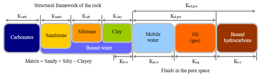
Fig.4. Three-component petrophysical model of terrigenous rock
Coefficients: Kef.por – effective porosity; Kd.por – dynamic porosity; Kb.w – bound water; Km.w – mobile water; Kog – oil and gas saturation; Kr.o – residual oil saturation
Criterion-based analysis
Prospective intervals were selected automatically when the following conditions were simultaneously met: Кsand ≥ 55 %, Kef.por = 8-15 %, Kperm < 1 mD, Kw > 40 %. These intervals are interpreted as lenses with preserved capacity but hindered drainage [32]. The proposed petrophysical modelling system is based on the concept of a three-component rock composition (sand – silt – clay), schematically presented in Fig.4. According to this concept, any terrigenous reservoir is considered as a system consisting of a structural framework and a pore space. The framework, in turn, is formed by sand, silt, and clay fractions, carbonate cement, rock fragments, and accessory minerals.
The key distinction and advantage of the used model is the joint consideration of the influence not only of the clay component, but also of the silt component on the integral physical parameters of the reservoir. This approach allows a more accurate description of the complex dependence of the physical properties of the structural framework on its fractional composition, surface charges of particles, mineralisation of formation fluids, and degree of oil and gas saturation. These factors directly determine adsorption processes and, consequently, the geophysical characteristics recorded in the well by the well logging suite. The methodology was developed based on arrays of digitised data from the standard WLD and laboratory core studies for 63 wells at key TSOGR fields. It rests on a three-component petrophysical model of sand-silt-clay rock, which enables quantitative determination – based on WLD data – of fractional composition of the rock matrix (content of sand, silt, and clay fractions), porosity, proportion of bound water, and absolute permeability.
The key principle of the methodology is to identify intervals in the section with an elevated proportion of the silt fraction (more than 50-60 %) where, with preserved porosity (8-15 %), a sharp deterioration in filtration properties (permeability less than 0.1-1 mD) and an anomalously high proportion of bound water (30-70 %) are observed. Such intervals, screened by clay interlayers, form isolated lenticular bodies (beds) where – under conditions of prolonged well downtime – residual oil reserves could be preserved or regenerated. The methodology application algorithm includes the following steps: comprehensive reinterpretation of WLD for wells, with estimation of the full set of petrophysical parameters; mapping of intervals meeting the specified criteria (silt composition, low permeability); correlation of these intervals between wells and delineation of geological bodies in volume; ranking of bodies by prospectivity; development of recommendations (deepening of existing wells or drilling new ones) [33].
The seismic survey coverage of the area under study is insufficient to unambiguously resolve the geology of any given structure, especially when the number of drilled wells is small. This is primarily due to the complex mountainous terrain and the presence of numerous settlements, a network of various communications, and agricultural lands – all of which limit the possibilities for conducting seismic exploration using explosive sources of excitation. The latter provide higher-quality information compared to vibroseis sources. In addition, the presence of anticlinal folds with near-E-W strike and narrow synclinal troughs between them necessitates laying rather long lines across the strike of the structures. Tie (near-E-W) 2D lines are of low informational value under the given conditions due to the superposition of numerous lateral waves. As a result, geometrisation of the structure and identification of various types of discontinuities complicate the task of building a representation of the hydrocarbon accumulation model. Given the difficulties in studying the Cretaceous structures by seismic methods, drilling operations come to the forefront; it is their results that provide the main understanding of the structures’ geology. The presence of reservoirs and their saturation within the studied deposit complex is determined by WLD and formation testing. Based on this criterion, the following are included in the group of priority geological exploration activity targets: fields already listed on the balance sheet under reserve category C2 (Goryacheistochnenskoye), fields with potential reserve growth from penetrated but untested formations (Mesketinskoye, Mineralnoye, Severo-Dzhalkinskoye). The second priority group includes targets with prospective resources listed under category C3 (Severo-Bragunskoye, Severo-Mineralnoye) [34].
After analysing the geological and geophysical data, a number of fields (accumulations) were classified as underexplored in terms of geological exploration activities. Among the Lower Cretaceous deposits, these include Goryacheistochnenskoye, Severo-Bragunskoye, Severo-Mineralnoye, and Khankalskoye. Based on the amount of possible incremental reserves (resources), the priority fields should be considered Severo-Mineralnoye, Severo-Bragunskoye, and Goryacheistochnenskoye. In these fields, the incremental reserves of industrial category C1 could amount to more than 1 million t across the entire accumulation area.
Based on an analysis of all available geological and geophysical information, we made a conclusion on the expediency of conducting further geological exploration targeting the Lower Cretaceous (Table 1), which is the aim of this study.
Table 1
Recommendations for conducting geological exploration within the prospective target boundaries
|
Prospect |
Prospective deposits |
Well number |
Recommendations |
|
Goryacheistochnenskaya |
Lower Cretaceous (Albian) |
121 |
Deepening |
|
Lower Cretaceous (Barremian) |
132, 135 |
Deepening |
|
|
Severo-Bragunskaya |
Lower Cretaceous (Aptian) |
20 |
Deepening |
|
32 |
Drilling a new well |
||
|
Severo-Mineralnaya |
Lower Cretaceous (Aptian) |
22 |
Deepening |
|
34 |
Drilling a new well |
Discussion
Goryacheistochnenskoye field
The prospects of this field are associated with category C2 reserves in the Albian and Barremian deposits. On the state balance sheet for the field, hydrocarbon reserves in category C2 are listed as follows: Albian deposits – oil – 1684/842 thousand t, dissolved gas – 346 million m3; Barremian deposits – oil – 1 042/521 thousand t, dissolved gas (category C2) – 201 million m3.
In 1992, well 145 was drilled to explore the Barremian accumulation, with a planned depth of 5250 m. The well was abandoned in 2005 due to technical issues, with the bottomhole at 4265 m in the Upper Cretaceous. Since the geological objectives set for well 145 remain unfulfilled, it is recommended to deepen well 135 for additional exploration of the C2 reserve area in the western part of the Barremian accumulation. In the eastern part of the accumulation, this task will be addressed by wells 131 and 134.
When analysing the actual geological and geophysical material and well testing data, the following positive criteria were identified, allowing for deepening of well 135 by 125 m, well 131 by 70 m, and well 134 by 90 m, with full penetration of the Barremian and subsequent testing of the penetrated deposits. The Barremian deposits of the Lower Cretaceous within the Goryacheistochnenskoye field are penetrated in eight wells (110, 111, 112, 122, 123, 130, 131, 135). Testing of the Barremian was carried out in four wells (111, 112, 122, 130), of which in wells 111 and 122 it was conducted jointly with formation V of the Aptian. In wells 112 (perforation) and 130 (open hole), inflows of water-free oil were obtained with production rates of 76 and 25 t/day, respectively. No inflow was obtained in wells 111 and 122.
According to the data from drilled wells, the Barremian deposits are not fully penetrated within the structure. The greatest penetrated thickness of deposits was recorded in well 130 and amounted to 123 m. The actual bottomhole of well 135 is in the Barremian deposits at a depth of 4932 m (−4618 m). The penetrated thickness of the Barremian is about 40 m. In well 131, the top of the Barremian was penetrated at a depth of 4966 m (−4694 m), while in well 134 it was not penetrated. Wells 131 and 134 are currently inactive. Consequently, their deepening to target the Barremian accumulation can be regarded as the most likely option.
In well 135, the top of the Barremian was penetrated in the crestal part of the structure, 25 m lower than in well 130, where the accumulation was being developed. In well 112, where an inflow of water-free oil from the Barremian was obtained, the top was penetrated 24 m lower than in well 135. Additionally, the absolute elevation of the upper hole of the perforation interval in well 130 (−4683 m) is recorded 65 m below the top of the Barremian penetrated in well 135. Taking this circumstance into account, in well 135 the Barremian deposits will be oil-saturated from the top down to the conventionally accepted oil-water contact at the elevation of −4800 m. Well 135 will address the task of transferring part of the reserves from category C2 to C1 in the western part of the accumulation. In this regard, to fully explore the accumulation in the eastern part, the option of deepening well 134 should be considered after completing the development of the Aptian accumulation. Like well 135, it will penetrate the Barremian accumulation within the area of C2 reserves. The bottomhole of well 134 is at a depth of 4986 m (−4657.5 m) in the deposits of member V2 of the Aptian. When comparing the thicknesses of the Lower Cretaceous based on well logging suite from nearby wells 110 and 112, the top of the Barremian in well 134 will be penetrated at a depth of about 4990 m (−4661.5 m). This is 21 m above the upper perforation hole in well 130 (where an oil inflow was obtained) and 138.5 m above the accepted position of the oil-water contact for the accumulation.
To further explore the accumulation in the Albian deposits, it is necessary to consider the option of repurposing wells that completed the development of the Upper Cretaceous or Aptian accumulations. The deposits of formation I of the Albian (Lower Cretaceous) within the Goryacheistochnenskoye field are penetrated in 22 wells. Testing of productive deposits was carried out in three wells (126, 134, 140). In wells 126 and 140 (weak inflow), oil inflows were obtained. In well 134, no inflow was obtained; the formation in this well is represented by low-permeability clayey reservoirs. Wells 126 and 140 penetrated the top of the pay on the western periclinal part of the structure, at elevations of −4502 m and −4655 m, respectively. In well 121, which is currently operating from the Aptian, the reservoirs of formation I were penetrated in the crestal part of the structure. According to WLD, formation I reservoirs are recorded at higher hypsometric levels than in wells 126 and 140 – at elevations of −4298 m and −4334 m, respectively (i.e., 204 m and 321 m higher). Consequently, well 121 – located in the centre of the accumulation within the C2 reserve area – is in more favourable conditions in terms of its hypsometric level than wells 126 and 140, where hydrocarbon inflows were obtained. The eastern part of the Albian accumulation, where a C2 reserve area is identified, can be further explored by testing in well 132 after the reserves in the Aptian and Barremian are depleted.
Severo-Bragunskoye field
To confirm the identified structural trap (anticline) in the Lower Cretaceous deposits, the previously prepared project provides for drilling exploration well 32 in the crestal part of the uplift. The planned exploration well is designed to penetrate the Aptian deposits to their full thickness, along with penetrating the top of the Barremian of the Lower Cretaceous. The planned depth of the exploration well is 5800 m. During the drilling of the well, it is proposed to conduct testing in the open hole and in the production casing. The test intervals are presented in Tables 2, 3.
Table 2
Open hole formation testing at the Severo-Bragunskaya prospect
|
Target number |
Age of deposits |
Test interval, m |
|
1 |
К1al |
5400-5430 |
|
2 |
К1a |
5520-5540 |
|
3 |
К1a |
5560-5600 |
|
4 |
К1a |
5635-5680 |
Table 3
Testing and development of formations in the production casing of the Severo-Bragunskaya prospect
|
Target number |
Perforation interval, m |
Age of deposits |
Inflow stimulation method |
|
1 |
5660-56755635-5650 |
К1а |
Hydrophobic acid emulsion |
|
2 |
5590-56005560-5570 |
К1а |
|
|
3 |
5520-5540 |
К1а |
|
|
4 |
5410-5425 |
К1аl |
If drilling a new exploration well is not possible, an alternative option is considered – deepening one of the wells 16, 20, 21, 31, or 80 – depending on their design and technical condition. These wells are in the crestal part of the structure, in more favourable hypsometric conditions compared to the planned well 32. According to WLD, the actual bottomholes of these wells are at the following depths: 4897 m and 5128 m (Upper Cretaceous), 4662 m (foraminiferous layers), 5430 m and 5080 m (Upper Cretaceous). Wells 31 and 80 are currently producing an oil accumulation in the Upper Cretaceous. Wells 16, 20, and 21 are observation ones. The option of deepening wells 16 and 31 is considered, since well 21 is targeted for side-tracking to penetrate the Upper Cretaceous. Given that the total thicknesses of the Cretaceous within the structure remain virtually unchanged, it is expected that well 16 could be deepened by 800 m from its actual bottomhole, well 31 could be deepened by 270 m.
Severo-Mineralnoye field
To achieve the set goals and objectives of exploring prospective Aptian deposits, drilling of exploration well 34 is planned. Location of well 34 is at the highest hypsometric elevation (approximately −5320 m) for Member II, between the drilled wells 22 and 33, in the expected oil zone of Members II and V of the western field. The selection of this location for the planned exploration well 34 is optimal because in the neighbouring well 33, during drilling through Member II of the Aptian, an intense oil and gas show was recorded; the wellhead pressure increased to 25 MPa.
The objective of drilling the planned exploration well 5800 m deep is to fully penetrate the Aptian sequence of the Lower Cretaceous, with entry into the upper part of the underlying Barremian deposits. The work programme provides for testing pay intervals in both the open hole and casing. The test intervals are specified in Tables 4 and 5.
Table 4
Open hole formation testing at the Severo-Mineralnaya prospect
|
Target number |
Age of deposits |
Test interval, m |
|
1 |
K1al (In) |
5370-5420 |
|
2 |
K1a (IIn) |
5555-5610 |
|
3 |
K1a (IVn) |
5655-5690 |
|
4 |
K1a (Vn) |
5730-5785 |
Table 5
Testing and development of formations in the production casing of the Severo-Mineralnaya prospect
|
Target number |
Perforation interval, m |
Age of deposits |
Inflow stimulation method |
|
1 |
5785-5730 |
K1a (Vn) |
Clay-acid treatment |
|
2 |
5610-5555 |
K1a (IIn) |
The practical tasks for additional exploration and further development of the Lower Cretaceous deposits, as outlined in the project documents of Grozneftegaz JSC and reflected in recent studies, are largely qualitative and predictive in nature. They identify promising fields (Khayan-Kortovskoye, Andreevskoye, Starogroznenskoye) and general horizons, but do not provide instrumental, quantitative justification for targeted geotechnical measures – such as deepening specific wells or precisely positioning new ones.
The methodology proposed in this work – for comprehensive reinterpretation of WLD based on the TABC technology (ESKS-TABC) within the Gintel environment – is designed to fill this methodological gap. Applying the methodology allows moving from stating general prospects to automated digital processing, interpretation, and identification of specific geological bodies – the so-called “siltstone lenses”. Thus, the methodology serves as a direct link between historically accumulated data (including datasets from Grozneftegaz JSC) and current objectives for enhancing oil recovery and further exploration. It provides a criterion-based background for selecting targets, which aligns with general conclusions about the high depletion rate and the potential for further development of the region’s Cretaceous deposits. In contrast to overview assessments, our reinterpretation of WLD across the well stock of the studied fields – using the TABC methodology – not only confirmed the prospects but also quantitatively identified the target interval (Fig.5). Analysis of the estimated parameters (Кsilt, Кtot.por, Кb.w) in well 707 of the Starogroznenskoye field revealed an isolated lens that meets the reservoir criteria with residual oil saturation. It is on the basis of this digital model that a specific proposal for perforating the well in the indicated intervals can be formulated.
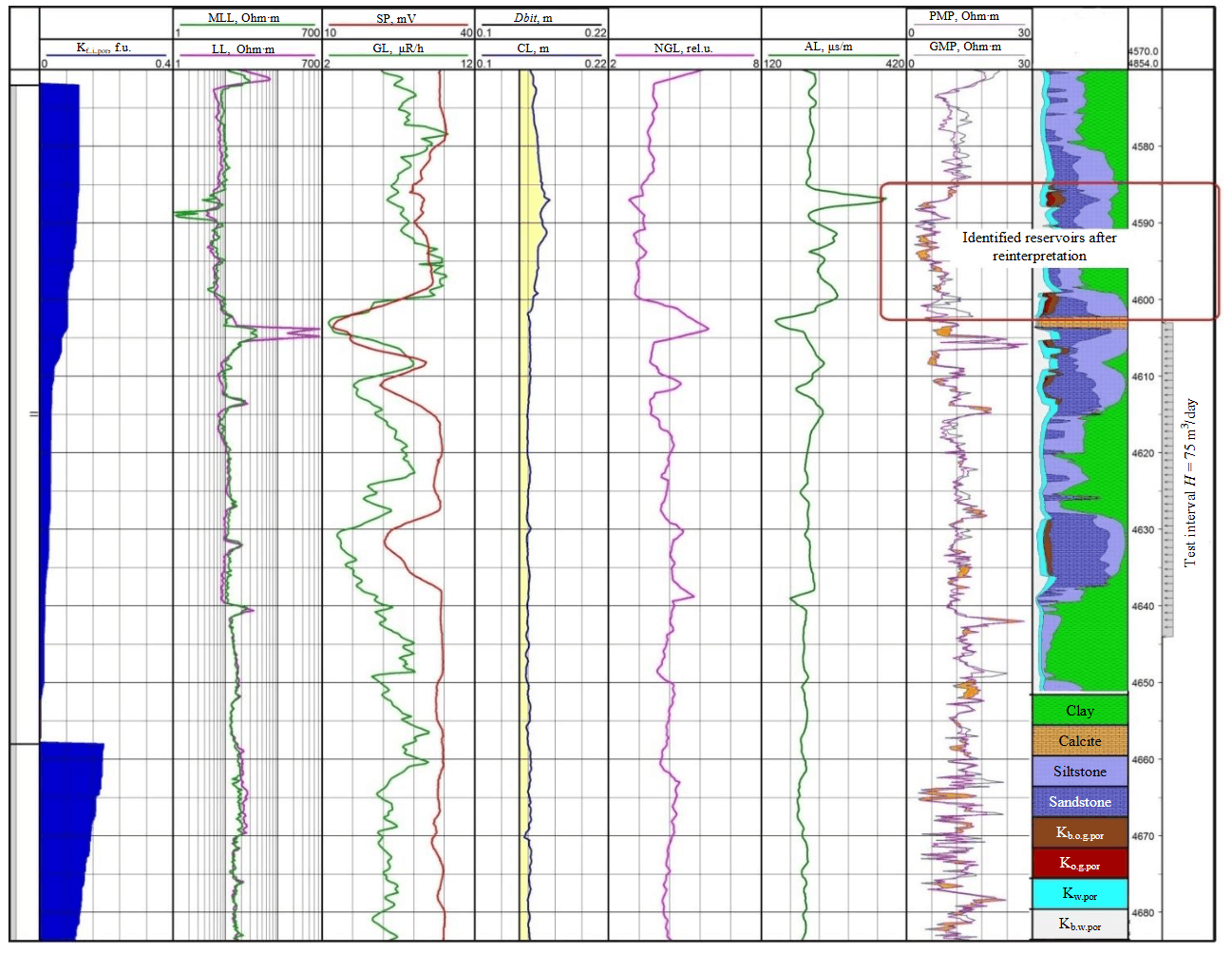
Fig.5. Result of WLD reinterpretation (Lower Cretaceous), Starogroznenskoye field, well 707
MLL – microlateral logging; LL – lateral logging; SP – spontaneous polarization; GL – gamma-ray logging; Dbit – bit diameter; CL – caliper logging; NGL – neutron gamma-ray logging; AL – acoustic logging; PMP – potential microprobe; GMP – gradient microprobe; coefficients: Kf.i.por – fracture interval porosity; Kb.o.g.por – bound (immobile) oil and gas porosity; Ko.g.por – total oil and gas porosity; Kw.por – water-saturated porosity; Kb.w.por – bound, water-saturated porosity
Conclusion
Oil exploration today is inseparable from advanced technologies and is accompanied by high risks and large investments. However, oil and gas horizons are located at great depths – in our case, from three to six thousand metres. According to statistics, only 20 % of exploration wells worldwide are drilled successfully, yielding a commercially viable inflow of oil and gas [35-37]. The cost of an exploration well exceeds one billion roubles. Yet despite such high investments, the probability of not achieving the set goals remains substantial – meaning the cost of an error is very high. This implies that improving the reliability of drilling results is a priority task for all researchers in this field [38]. As computer innovations and technology progress advance, IT technologies and artificial intelligence become an integral part of research methods in oil and gas prospecting and exploration. This leads to deeper interpretation and more detailed study of subsurface geology [39-41].
The study, which combines a historical analysis of the exploration level of the Lower Cretaceous deposits in the TSOGR with the use of modern digital interpretation technologies, allows us to formulate the following main conclusions:
* An analysis of the evolution of geological and geophysical research since the late 19th century showed that by the end of the active geological exploration activities in the region (early 1990s), a fairly detailed dataset was formed. However, its potential for identifying unconventional traps remained untapped due to the focus of traditional methods on highly permeable sandstone reservoirs.
* To address the task of identifying “missed” accumulations, the ESKS-TABC integrated interpretation technology was adapted and applied in selected wells using the Gintel software. The key advantage for TSOGR conditions is the three-component petrophysical model, which allows quantitative identification of intervals dominated by silts fractions with complex porosity (8-15 %), low permeability (< 1 mD), and anomalously high proportion of bound water (30-70 %). This is interpreted as an indicator of residual oil presence. Digitization and reinterpretation of WLD using the ESKS-TABC methodology, machine learning, and neural networks – across all fields drilled to date targeting the Lower Cretaceous in the TSOGR, combined with seismic survey data – will enable the construction of a 3D model of the distribution of lithological features and reservoir properties throughout the entire depth range. Such a model will serve as a source of new geological information and can largely replace a number of existing schematic maps and cross-sections. This approach will allow issuing recommendations for deepening the Upper Cretaceous wells from the inactive well stock into the Lower Cretaceous at three fields: Goryacheistochnenskoye, Severo-Bragunskoye, and Severo-Mineralnoye. This solution is significantly more cost-effective than constructing new wells.
- The novelty of this work lies not in stating the general prospectivity of further exploration, but in shifting to targeted, technology justified solutions. Each recommendation stems from the results of a digital petrophysical model verified against core data, which minimises risks and enhances economic efficiency by prioritising deepening of the existing well stock over costly new drilling.
- The proposed approach provides a background for replication at other TSOGR fields and similar old oil and gas provinces. Further development is linked to integrating the results with 3D seismic survey data to build 3D geological models and applying machine learning algorithms for automated forecasting.
Thus, the study and reinterpretation of WLD is an important tool for improving the efficiency of geological exploration activities, which will ultimately contribute to the discovery of new pay intervals. Further research on the Albian-Aptian deposits should also focus on testing new geophysical methods, clarifying the influence of component composition on key petrophysical relationships and the results of geophysical methods, reinterpreting existing WLD using modern automated data processing and interpretation systems. Advanced technologies – including digital data processing, seismic modelling, and machine learning algorithms – will make it possible to revise outdated methodologies and interpretation results, and to identify new prospective zones by constructing a 3D geological-geophysical model of hydrocarbon accumulations [42, 43].
References
- Irving E., North F.K., Couillard R. Oil, Climate, and Tectonics. Canadian Journal of Earth Sciences. 1974. Vol. 11. N 1, p. 1-17. DOI: 10.1139/e74-001
- Luginets I.P. The problem of oil-gas saturation in the Mesozoic sediments of the lower Yenisei. International Geology Review. 1959. Vol. 1. Iss. 9, p. 24-27. DOI: 10.1080/00206815909473439
- Yunhua Deng, Yongcai Yang, Ting Yang. Three systems of the oil and gas formation in the world. Petroleum Research. 2025. Vol. 10. Iss. 1, p. 1-27. DOI: 10.1016/j.ptlrs.2024.06.008
- Aladwani N.S., Alenezi A., Diab A. Investigation of the Cretaceous total petroleum system using wireline logs, core, and geochemical data in Bahrah Field, Northern Basin, Kuwait. Journal of Petroleum Exploration and Production Technology. 2023. Vol. 13. Iss. 1, p. 381-406. DOI: 10.1007/s13202-022-01556-4
- Zhang Yinguo, Chen Qinghua, Sun Ke et al. Characteristics and influencing factors of Cretaceous reservoir in eastern depression of North Yellow Sea basin. Journal of Petroleum Exploration and Production Technology. 2022. Vol. 12. Iss. 7, p. 1907-1918. DOI: 10.1007/s13202-021-01362-4
- Ming-jian Wang, Guo-lin Xiao, Chang-qing Yang et al. Characteristics and evaluation of Mesozoic source rocks in the southeastern East China Sea continental shelf. China Geology. 2019. Vol. 2. Iss. 2, p. 133-141. DOI: 10.31035/cg2018079
- Yashchenko I.G., Krupitsky V.V., Polishchuk Yu.M. Features of changes in the physico-chemical properties of oils in connection with great depths. Georesursy. 2021. Vol. 23. N 3, p. 99-108 (in Russian). DOI: 10.18599/grs.2021.3.13С. 99-108
- Elhossainy M.M., El-Shafeiy M., Al-Areeq N.M., Hamdy D. Petroleum generation modelling of the Middle-Late Cretaceous sediments in the Abu Gharadig Field, Northwestern Desert, Egypt. Geological Journal. 2022. Vol. 57. Iss. 9, p. 3851-3880. DOI: 10.1002/gj.4519
- Hassan S., Tahoun S.S., Darwish M. et al. The Albian – Cenomanian boundary on the southern Tethyan margin: Abu Gharadig Basin, Northern Western Desert, Egypt. Marine and Petroleum Geology. 2023. Vol. 154. N 106334. DOI: 10.1016/j.marpetgeo.2023.106334
- Madisheva R.K., Portnov V.S., Amangeldiyeva G.B. et al. Geochemical prerequisites for the formation of oil and gas accumulation zones in the South Turgay basin, Kazakhstan. Acta Geochimica. 2024. Vol. 43. Iss. 3, p. 520-534. DOI: 10.1007/s11631-023-00660-4
- Rajabli O.V. Paleotectonic characteristics and oil-gas content of Mesozoic sediment accumulation in the Yalama-Khudat uplift zone. Scientific Petroleum. 2023. N 2, p. 6-12. DOI: 10.53404/Sci.Petro.20230200042
- Kirillova G.L. Late Mesozoic–Cenozoic sedimentary basins of active continental margin of Southeast Russia: paleogeography, tectonics, and coal–oil–gas presence. Marine and Petroleum Geology. 2003. Vol. 20. Iss. 3-4, p. 385-397. DOI: 10.1016/S0264-8172(03)00046-1
- Karakash N.I. Cretaceous deposits of the northern slope of the Main Caucasus Range and their fauna. St.Petersburg: Tipografiya M.M.Stasyulevicha, 1897, p. 205 (in Russian).
- Kholodov V.N., Nedumov R.I. Lithology and geochemistry of middle miocene East Predcaucasus. Moscow: Nauka, 1981, p. 205 (in Russian).
- Rengarten V.P. Lower Cretaceous deposits. Geologiya SSSR. Vol. IX. Severnyi Kavkaz. Part. 1. Geologicheskoe opisanie. Moscow; Leningrad: Gosudarstvennoe izdatelstvo geologicheskoi literatury Ministerstva geologii SSSR, 1947, p. 170-205 (in Russian).
- Golovlev A.A. Geological and geomorphological features of mountainous Chechnya. Samarskaya Luka. 2007. Vol. 16. N 4 (22), p. 689-707 (in Russian).
- Tari G., Blackbourn G., Boote D.R.D. et al. Exploration plays in the Caucasus Region. Journal of Petroleum Geology. 2021. Vol. 44. Iss. 3, p. 213-236. DOI: 10.1111/jpg.12791
- Barkovskaia M. Contributions to the petrography of the upper Jurassic and lower cretaceous deposits on the Belaia river (North–Caucasus). Zapiski Vserossiiskogo mineralogicheskogo оbshchestva. 1937. Vol. 66. N 3, p. 523-545 (in Russian).
- Konyukhov I.A., Burlin Yu.K., Seregin F.M. Lower Cretaceous deposits of the Northern Caucasus and their lithofacies changes. Geologiya nefti. 1958. N 4, p. 49-56 (in Russian).
- Konyukhov I.A. Experience in studying Mesozoic deposits of the Eastern Ciscaucasia (in connection with the oil and gas potential prospects). Moscow: GOSINTI, 1958, p. 127 (in Russian).
- Sazonova I.G. Lower Cretaceous deposits. Trudy VNIGNI. Iss. X. Geologicheskie i geokhimicheskie issledovaniya. Leningrad: Gostoptekhizdat, 1958, p. 86-99 (in Russian).
- Salamatin A.E. Regional stratigraphic chart of the Lower Cretaceous of the North-Eastern Caucasus. Izvestiya Severo-Kavkazskogo nauchnogo tsentra vysshei shkoly. Estestvennye nauki. 1972. N 2, p. 74-79 (in Russian).
- Ulmishek B.F. Petroleum Geology and Resources of the Middle Caspian Basin, Former Soviet Union. U.S. Geological Survey Bulletin 2201–A. Denver: U.S. Department of the Interior, Geological Survey, 2001. Version 1.0. 38 p. DOI: 10.3133/b2201A
- Smolyaninova K.I. Reservoir features of the Lower Cretaceous rocks of the Tersko-Sunzhensky oil region at depths over 3000 m. Trudy Instituta neftekhimicheskoi i gazovoi promyshlennosti im. I.M.Gubkina. Iss. 123, 124. Izuchenie kollektorov nefti i gaza, zalegayushchikh na bolshoi glubine. Moscow: Nedra, 1977, p. 130-132 (in Russian).
- Daukaev A.A., Abubakarova E.A., Bachaeva T.H., Sarychev V.I. Research of the natural replenishment mechanisms of hydrocarbon deposits (using the example of the Starogroznenskoye oil and gas field). Izvestiya Tula State University. Earth Sciences. 2023. N 4, p. 62-73 (in Russian).
- Uzdieva N.S., Nuradinov A.S. Restoration and priority areas for development of the oil and gas production complex in the Chechen Republic. Sovremennye problemy geologii, geofiziki i geoekologii Severnogo Kavkaza. Moscow: Institut istorii estestvoznaniya i tekhniki im. S.I.Vavilova RAN, 2022. Vol. XII, p. 208-213 (in Russian).
- Shnurman I.G. Study of terrigenous reservoirs of the Ciscaucasia based on the results of geophysical well surveys. Krasnodar: Prosveshchenie-Yug, 2003, p. 397 (in Russian).
- Khasanov M.A., Ezirbaev T.B. Petrophysical characteristics of terrigenous low cretaceous paying reservoirs in Terek-Sunzha oil and gas region as a basis for well logging data interpretation. Karotazhnik. 2009. N 8 (185), p. 3-9 (in Russian).
- Afanasiev S.V., Khasanov M.A., Ezirbaev T.B. Substantiation of electric conductivity model for Aptian deposits of Tersko-Sunzhensky oil and gas bearing area. Automation, telemechanization and communication in oil industry. 2011. N 8, p. 41-43 (in Russian).
- Ezirbaev T.B. Methodology for interpreting well logging data in terrigenous silt-clay and fractured rocks using the example of deposits of the Tersko-Sunzhenskaya oil and gas region: Avtoref. diss. … kand. tekhn. nauk. Moscow: Rossiiskii gosudarstvennyi geologorazvedochnyi universitet im. Sergo Ordzhonikidze, 2012, p. 29 (in Russian).
- Daukav A.A., Gaysumov M.Ya., Badaev S.V. Pre-Jurassic basement of the terek-caspian basin in connection with the problem of deep oil and the formation of its accumulations. Geology and Geophysics of Russian South. 2023. Vol. 13. N 3, p. 131-144 (in Russian). DOI 10.46698/VNC.2023.19.53.010
- Ezirbaev T.B. The Lower Cretaceous reservoir of the Starogroznenkoye oil and gas field as an object of geological modeling. Geology and Geophysics of Russian South. 2025. Vol. 15. N 3, p. 239-254 (in Russian). DOI 10.46698/VNC.2025.27.39.001
- Ezirbaev T.B. Review of technologies for integrated processing of reinterpretation of well logging data for detailed dissection of the section and revaluation of hydrocarbon reserves. Geology and Geophysics of Russian South. 2021. Vol. 11. N 2, p. 118-136 (in Russian). DOI: 10.46698/VNC.2021.40.15.009
- Kuleshkov I.V., Danilchenko O.N., Kolbikova V.V., Kolbikov V.S. Generalization of the experience of developing oil fields in the Chechen Republic and scientific justification for their promising further development. Nauchno-tekhnicheskii vestnik OAO “NK “Rosneft”. 2008. N 4, p. 28-35 (in Russian). URL: https://www.rosneft.ru/upload/site1/document_publication/177145/v04_2008.pdf (accessed 20.12.2025).
- Animah I., Shafiee M. Condition assessment, remaining useful life prediction and life extension decision making for offshore oil and gas assets. Journal of Loss Prevention in the Process Industries. 2018. Vol. 53, p. 17-28. DOI: 10.1016/j.jlp.2017.04.030
- Nasibova G., Ismayilzadeh E., Ganbarova S., Ismayilova M. Oil and gas prospects of tectonic crashing zones of the Kura intermountain depression. Reliability: Theory & Applications. 2023. Vol. 18. Special Issue N 5 (75), p. 313-322. DOI: 10.24412/1932-2321-2023-575-313-322
- Yunsheng Wei, Ailin Jia, Yanmei Xu, Jianlong Fang. Progress on the different methods of reserves calculation in the whole life cycle of gas reservoir development. Journal of Natural Gas Geoscience. 2021. Vol. 6. Iss. 1, p. 55-63. DOI: 10.1016/j.jnggs.2021.04.001
- Dvoynikov M., Kutuzov P. Identification of Critical and Post-Critical States of a Drill String Under Dynamic Conditions During the Deepening of Directional Wells. Eng. 2025. Vol. 6. Iss. 11, p. 1-21. DOI: 10.3390/eng6110306
- Rahmawan S., Yasmaniar G., Prakoso S. Rock quality grouping in sandstone formation using a critical porosity approach at formation pressure conditions. Petro: Jurnal Ilmiah Teknik Perminyakan. 2020. Vol. 9. N 4, p. 167-173. DOI: 10.25105/petro.v9i4.8203
- Dong Liu, Fengyi Zhang, Qin Zhu et al. Quantitative Characterization and Dynamic Law of Interlayer Interference for Multilayer Commingled Production in Heavy Oil Reservoirs by Numerical Simulation. World Journal of Engineering and Technology. 2019. Vol. 7. N 3, p. 379-395. DOI: 10.4236/wjet.2019.73028
- Prishchepa O.M., Borovikov I.S., Grokhotov E.I. Oil and gas content of the understudied part in the northwest of the Timan-Pechora oil and gas province according to the results of basin modeling. Journal of Mining Institute. 2021. Vol. 247, p. 66-81. DOI: 10.31897/PMI.2021.1.8
- Bechtel A., Jianliang Jia, Strobl S.A.I. et al. Palaeoenvironmental conditions during deposition of the Upper Cretaceous oil shale sequences in the Songliao Basin (NE China): Implications from geochemical analysis. Organic Geochemistry. 2012. Vol. 46, p. 76-95. DOI: 10.1016/j.orggeochem.2012.02.003
- Yunhua Deng, Yongcai Yang, Ting Yang. Three systems of the oil and gas formation in the world. Petroleum Research. 2025. Vol. 10. Iss. 1, p. 1-27. DOI: 10.1016/j.ptlrs.2024.06.008