Geometric models of typical complex-structured bench blocks
- 1 — Ph.D., Dr.Sci. Professor Satbayev University ▪ Orcid ▪ Scopus ▪ ResearcherID
- 2 — Ph.D., Dr.Sci. General Director Mining Bureau LLP ▪ Orcid ▪ Scopus
- 3 — Ph.D., Dr.Sci. Professor Satbayev University ▪ Orcid ▪ Scopus ▪ ResearcherID
- 4 — Ph.D. Associate Professor Almaty University of Power Engineering and Telecommunications named after Gumarbek Daukeyev ▪ Orcid ▪ Scopus ▪ ResearcherID
- 5 — Senior Lecturer Satbayev University ▪ Orcid ▪ ResearcherID
- 6 — Postgraduate Student Satbayev University ▪ Orcid
Abstract
More complete extraction of minerals from subsurface by reducing their losses even more actualizes tasks of improving mathematical models of mining objects. Purpose of this work is to create geometric models of typical complex-structured blocks (CSB), which could be extended to real CSB. They are based on mining and geological models of virtual (typical) complex-structured ore blocks of bench, consisting of discontinuous continuous (first type) and dispersed ore bodies (second type). These blocks key parameters are isolated continuous and dispersed ore bodies characteristic points coordinates, ore bodies with host rocks contact line segments length, and ore bodies areas in CSB sections. They determine these objects mining and geological characteristics (ore saturation, block geological and morphological structure complexity). These characteristics are analytically interconnected with disparate ore bodies geometric parameters and admixed rock or lost ore layer size. They are the basis for CSB geometric models numerical values calculation methodology and mining and geological characteristics of ore bodies and whole block. Computer program for automated determination of geometrical characteristics of CSB by given initial key parameters of complex-structured blocks has been created. Example of calculation of these characteristics for typical complex-structured blocks is considered, and significance of research results in CSB development is shown. Proposed methodology of calculation of key characteristics of geometrical models of CSB is an information basis for making decisions on economical and ecological development of CSB of benches. Results of research can be used in exploitation of real complex-structured deposits to significantly reduce loss and dilution of minerals.
The article was prepared as part of a project funded by the Ministry of Science and Higher Education of the Republic of Kazakhstan 2023/AP19676591 “Development of innovative technologies for the complete extraction of scattered conditioned ores from complex-structural blocks of benches”.
Introduction
Various integrated geographic information systems are now widely used in the design, planning and development of solid minerals. They are based on geological exploration data of specific fields. The spatial distribution of minerals in the geological field under consideration is presented in the form of general geological and mathematical models.
The problem of extracting more minerals from the subsoil by reducing losses makes it even more important to improve the models of development sites. The use of software products containing the coordinates of landmark points of ore bodies, their areas, the lengths of segments separating them and the host rock, the content of useful components in various ore bodies, and the physical, mechanical, and technological properties of ore bodies will automate the labor-intensive process of geometrizing complex mineral deposits.
Complex deposits are usually represented by a diverse combination of ore bodies and host rocks (substandard ores) of complex configuration with varying sizes, physical, technical, and geological characteristics. Contacts between conditioned and substandard ores are visually indistinguishable and are of a probabilistic nature [1-3]. Their share at non-ferrous metallurgy enterprises of CIS countries is 60-90 %, and operational losses of ore can reach 20-35 % [3-6].
The main reasons for high losses and depletion in open-pit mining of complex-structured minerals are insufficient knowledge of the geological and morphological structure of complex-structured blocks (CSB) of benches. There is a mismatch between the technologies used for excavation and loading operations and the actual geological conditions of complex mineral deposits in the rock mass and in a blasted state, as well as the use of specific methods for determining loss and dilution rates, which are focused on geological objects with clear geological boundaries – veins, lenses, and stratification of deposits. Quantitative and qualitative losses of minerals in them are usually established for the contour areas of ore blocks [6, 7].
In the software products Datamine, Surpac, Micromine, etc., the problem of loss and dilution management is considered on the scale of the whole deposit, but not in the section of a bench, a separate mining unit (excavator drift). For their adaptation to geological objects of smaller scale (horizon, bench) of complex configuration and structure there is a need to create appropriate mining and geological, mathematical models that serve as a basis for the development of methods for determining and rationing of operational quantitative and qualitative losses in real conditions of minerals development.
Naturally, the primary of these models is the mining and geological model of complex ore blocks of benches. It explicitly depicts ore bodies in various cross-sections of the bench (transverse, longitudinal, horizontal) and the locations of ore losses and dilution during their excavation from real complex-structured ore blocks (CSOB). Such a model was first created by us for virtual complex-structured ore blocks of benches [4, 5] and can serve as a basis for creating geometric models of typical CSB of benches.
Literature review
Geometric modeling involves the construction of mathematical models that describe the geometric properties of the object under study. It is based on analytical and differential geometry, computational mathematics, calculus of variations, topology, and computer technologies.
Since its inception more than five decades ago, geometric solid modeling has been crucial for engineering design purposes and is used in engineering software packages such as computer-aided design, computer-aided manufacturing, computer-aided engineering, etc. [8].
The paper [9] presents a new approach to generate generalized developable cubic trigonometric Bézier surfaces with shape parameters to solve the fundamental problem of local surface shape tuning.
In [10] generalized Bernstein-type functions with different shape parameters are used. The parametric and geometric conditions in generalized form are developed. Some numerical examples of parametric continuity and geometric continuity constraints of generalized Bézier-type curves are analyzed with graphical representation.
In [11], an algorithm is proposed for calculating a composite bicubic surface with a fixed framework formed by longitudinal (along the x-axis) and transverse (along the y-axis) cubic splines. The equations of the frame lines are taken as the main boundary conditions. According to the proposed algorithm, the task consists of two stages: first, the equations of the frame lines are found, then the coefficients for the equations of the bicubic portions forming the bicubic surface are calculated. This approach allows reducing the size of the characteristic matrix of the system of linear equations relative to the coefficients included in the surface equation.
The paper [12] presents the main aspects of modeling special objects for mining enterprises that are not found in civil and industrial construction projects – quarry surfaces, underground mine workings of various configurations, volumetric rock blocks, and earth masses. The article demonstrates ways of using information modeling, which is actively developing in the field of construction, which involves the creation of a unified information model of an object that reflects the entire life cycle of a structure from design to operation and further liquidation of the deposit. This will help avoid most mistakes during the design phase and enable real-time monitoring of extraction and processing during preparatory and cleanup work. The models created for mining enterprises demonstrate the possibilities of using software for information modeling and creating a unified object file from the design stage to the completion of mining operations, and further on to the accounting of reclamation or use of the object in a new functional capacity.
The geometrization of qualitative and physical indicators and chemical properties of rocks and minerals is of particular importance for ore deposits, which is one of the most important tasks of mining enterprises [13]. The graphical-analytical method allows establishing the distribution of component content and creating a spatial model of the deposit to determine the relationships between them [14]. These tasks can be solved on the basis of a complex of studies aimed at geometrization, statistical evaluation of the deposit, modeling and monitoring of its shape, properties, and volumes [15].
Geologists and mining engineers commonly use geometric and geostatistical methods to estimate tonnage and grade of ore reserves [16]. However, no clear estimates of the differences between these methods have been reported in the literature. To fill this research gap, a comparative study of the quality reserves of the Oyo-Iwa limestone deposit located in Nigeria using geometric and geostatistical methods is carried out. The geometric method is effective for estimating tonnage, while the geostatistical method, in the authors’ opinion, is more suitable, reliable, and preferable for estimating grade [16].
Work [17] provides a comprehensive review of articles in which machine learning was used to assess mineral resources. The review discusses popular machine learning methods, their implementation, and limitations. Articles that conducted a comparative analysis of traditional and machine learning methods were also reviewed. Machine learning models can take into account several geological parameters and effectively approximate complex nonlinear relationships between them, demonstrating superior performance compared to traditional methods.
Geostatistical methods are usually practical at the development and production stages of mining projects. However, when developing deposits with heterogeneous mineral content, they do not take this feature into account [18]. The variability and unevenness of iron ore content require in-depth scientific study with the creation of appropriate geometric models.
In [19], the Itakpe (Nigeria) iron ore deposit is re-examined using geostatistical and artificial neural network techniques. The exploration dataset of the deposit is used to develop a normal kriging model that gives the minimum error.
In [20], the authors propose methods for assessing the qualitative indicators of minerals based on block modeling technologies using modern mining and geological information systems (MGIS). One of the modeling stages is the construction of wireframe models of ore bodies, which is essentially geometric modeling.
An improvement in the methodology for geometrizing the quality indicators of iron ore deposits has been demonstrated for the construction of a mining-geometric model of the deposit that would make it possible to describe the patterns of distribution of the most important quality indicators in space [21]. The improved methods allow predicting the quality indicators of mineral extraction for solving the tasks of prospective and current planning of mining operations. It is shown that it is advisable to use a system of equations of a multidimensional random geochemical field as a mathematical description of the elements of the predicted rock mass.
Geometric modeling is an important tool for demonstrating and confirming the qualitative and quantitative indicators of ore saturation of a separate site or deposit as a whole in two-dimensional and three-dimensional spaces. The construction of a geometric model strongly depends on the quality of input data and the reliability of geological information, their volume and frequency of updating. Article [22] discusses dynamic data update as one of the metrics for evaluating three-dimensional geological modeling methods.
Using implicit modeling in Leapfrog Geo software, a 3D lithological model was created that matches the shape and orientation (strike and dip) of the rocks obtained from surface mapping [23]. Implicit modeling is accurate, flexible, and efficient compared to explicit methodology. It was used as a semi-automatic tool, as it was necessary to refine the modeling parameters in accordance with local geological characteristics.
An algorithm of spatial constraints has been developed for constructing a synthetic (virtual) ore body model based on incomplete geological exploration data for mineral deposits, in particular the Malmberget iron ore deposit (Sweden) [24]. The authors propose using a generated block model of the deposit to predict the impact of mineral extraction in order to select the optimal mining strategy.
In [25], combinatorial constraints of multiple fields are presented for implicit modeling of ore bodies based on the idea of interpolation of implicit function fields. Three basic combinations of intersection, union and difference are defined to represent the combined relationship between subfields. Experimental results from several datasets demonstrate that multiple field combination constraints are applicable to a range of typical situations in implicit ore body modeling. Implicit modeling is a promising method for ore body modeling. However, when borehole data are scarce with large intervals, reconstructions without manual constraints are likely to lead to discontinuities. The reliability of implicit modeling with insufficient drillhole data depends largely on the construction of interpolation constraints and geological rules.
In [26], a method is also presented to improve the 3D model of ore bodies in the Xiangxibei lead-zinc deposit in northwestern Hunan County (China). It is based on big data analysis to offset the effect of uncertainty and lack of exploration data on the grade of minerals. In general, these methods can improve the mineral reserves planning strategy and better predict the geometry of ore bodies.
In [27], an example of using the Delaunay grid to build a geometric model of ore bodies with a more accurate shape, in contrast to the classical quadrilateral shape, is shown. Delaunay grid allowed to achieve high accuracy in calculations and modeling of physical processes occurring in ore bodies. The results show the importance of taking into account the shape of the geometric model of ore bodies for further mining calculations.
In [28], the Hermite Radial Basis Function algorithm is used to directly interpolate the boundary points of the geological data of the borehole and its normal direction to realize the construction of an implicit 3D ore body model. This method has a high degree of automation, high geometric quality of the model and fast update speed, in contrast to the contouring methods of ore bodies.
Work [29] highlights the distinctive features of information technologies in mining. Examples are given of the digitization of planning and geomechanical safety assurance for mining operations, mass blasting, and backfilling. The most important element of digital technology in mining is the information system, whose main purpose is to create models of mining technology objects and provide tools for using these models in solving engineering problems in mining operations. Due to the specific nature of mining (the absence of identical deposits and natural conditions for mining operations, constant changes in the geometry of the mined space, the influence of economic factors on the sequence of mining units, etc.), mining and geological information systems are usually used to work with the corresponding models. The authors note that the availability of a digital model of a mining enterprise opens up wide opportunities for the automation of technological processes, improving the safety of mining operations and transitioning to low-labor technologies, which will ultimately reduce the cost of mineral extraction.
One of the most important classes of software used in mining enterprises are mining and geological information systems – information systems for the comprehensive automation of geological, surveying, and technological tasks when working with vector, frame, and block models of mining technology objects. MGIS allows to obtain reliable information about the deposit at each stage of exploration, design, and operation by using three-dimensional geological and geomechanical models, determining the patterns of distribution of useful and harmful components of minerals for a comprehensive analysis of scenarios for the sequence of deposit development, selecting the most effective technologies and equipment, and assessing the risk level of design solutions and their economic efficiency [30].
The process of introducing digital technologies in mining is evolutionary in nature and began with the advent of electronic computers in large enterprises, design and scientific organizations. At the initial stage, the use of computers in mining technology was mainly for demonstration purposes. The development of work in this direction led to the differentiation of the general system into separate areas: mining and geological information systems; geomechanical safety systems; dispatching; and solutions to specific mining technology problems. One of the areas of digital transformation is MGIS, which has evolved from assessing deposit reserves to modeling mining technology facilities, tools for solving surveying tasks, and designing and planning mining operations. Assessing the functionality of MGIS known on the market, it can be stated that their current level of development generally meets the requirements of the “Digital mine” – a way of representing mining technology objects and mining technology processes in the form of digital models that describe the properties and behavior of real objects in a unified digital space of the enterprise. The next stage of digital transformation is the digital twin, which can be characterized as a “Digital mine” with real-time communication links between existing equipment units and their digital models. The creation of a digital twin involves real-time reproduction of the functioning of a natural-technical system, reflecting its actual or predicted state [31].
Current trends in the development of information support tools for mining technology dictate the need for a comprehensive solution to technological problems based on a single software platform that ensures rapid adaptation of basic functionality to the conditions of a mining enterprise and the deve-lopment of new functionality. The ideology of building and developing information systems is of key importance in this regard. The modeling methodology proposed in the study [32] is suitable for solving the current tasks of the geological service of mining enterprises. Software tools and instruments have been developed, such as the selection of ore condition and grade intervals, multi-criteria sampling of survey data to estimate the reserves of useful components in the deposit as a whole and in mining units, as well as interactive input of geophysical surveys for underground mining operations. The program builds block and sub-block models of different parts of the deposit, but it is not specified how individual ore bodies in the array are taken into account.
A review of the literature shows that issues of global and local mathematical (geometric) modeling of mineral deposits and their constituent elements are relevant and important. Problems of more complete extraction of minerals from the subsoil require a reliable assessment of the geological and morphological structure of complex deposits in the section of the benches, their individual blocks undergoing mining. The degree of complexity of the structure of such deposits is determined by the number of ore and rock layers, their thickness and angle of dip, as well as the number of ore grades requiring separate extraction.
The article justifies the creation of geometric models of typical CSB of benches – elements of complex-structured mineral deposits.
Research methods
Types of complex-structured blocks of benches and their mining and geological characteristics
The geometric models of typical CSB of benches are based on the geometric dimensions of scattered continuous ore bodies with identified content of useful components, contact lines with host rocks (non-conforming ores), thickness of mixed rocks (non-conforming ores), and mining and geological characteristics. The purpose of geometric modeling of complex-structured bench blocks is not only to represent as accurately as possible the dimensions, boundaries of ore bodies, internal geometry of the deposit, content and value of useful components in them, but also to analytically describe the relationship between the mining and technological characteristics of the bench CSB and the specified properties.
The theoretical interpretation of the works [2-5] shows that, based on the nature of the spatial arrangement of ore bodies in a bench block and their geometric parameters, complex-structured bench blocks can generally be divided into two types.
In the new, modernized classification of complex-structured bench blocks, ore bodies are understood as volumes of conditioned ore reserves established based on the results of analysis of blasthole samples and other geophysical methods. They do not always coincide with the balance reserves of ores, since they are identified as a result of further exploration. It is also assumed that rock interlayers contain non-marketable ores.
The first type of CSB of benches includes blocks composed of scattered continuous ore bodies of various shapes and sizes, with certain physical, mechanical, and technological properties, as well as the content of useful and harmful components. They have straight-line contacts with the host rock layers [4, 5] (Fig.1).
The second type of CSB of benches is represented by blocks composed of scattered ore bodies in the form of geometric figures of various shapes and sizes, for example, polygons with certain physical, mechanical, and technological properties and containing useful and harmful components. They have straight-line contacts with the host rocks [4, 5] (Fig.2).
The CSB diagrams shown in Fig.1, 2 allow the geometric parameters of the geological and morphological structure of the block to be classified based on an analytical description of their technological characteristics.
Fig.1. Complex-structured blocks of benches composed of scattered continuous ore bodies
h – block height; a – layer thickness;3a – block width; Si – area of the i-th ore body, i = 1, 2, …, 7; A1, A2, ..., D3 – characteristic points of ore bodies; A2A3, B1B2, B2B3, ..., D1D2 – lengths of contact lines of the i-th ore body with the host rocks; α – the bench slope angle; β – the dip angle of the ore body
Fig.2. Complex structural blocks composed of scattered ore bodies
Si – area of the i-th ore body, i = 1, 2, …, 9; A1, A2, …, D7 – characteristic points of ore bodies; A2B2, B1B2, …, C5C6, C5D5, C6D6 – lengths of the contact lines of the i-th ore body with the surrounding rocks
The most common and relatively easy-to-measure values [4, 5] are considered as the desired mining and geological characteristics: the ore yield coefficient and the index of complexity of the geological and morphological structure of the block.
The ore yield coefficient of the block is calculated for a given section using the formula [4, 5]
across the entire block according to the dependence
where Si is the area of the i-th ore body on a given block section, m2; Sb is the area of the section of the complex-structured block under consideration, m2; n is the number of ore bodies; m is the number of sections per block; j is the index of the current block section.
The coefficient of complexity of the geological and morphological structure of the block at the section under consideration is determined by the dependence [4]
where li is the length of the contact lines of the i-th ore body with the host rocks (substandard ores) at a given section, m; t is the thickness of the layer of host rocks (ores) that fall into the ore mass (shipped rock) during excavation, m.
Results
Dimensions of elements of geometric models of typical complex-structured blocks
In order to reveal in more detail the essence of the proposed models and methods for determining the geometric parameters of the geological structure of complex-structured mineral deposits, their numerical values for the types of CSB under consideration were analyzed. In the calculations given, the height of the block is taken to be equal to the height of the bench – 10 m, the width of the smallest worked block is 9 m, and the angle of the bench slope is 65°.
To create geometric models of typical complex-structured blocks, it is first necessary to find the coordinates of characteristic points of scattered continuous and dispersed ore bodies of the CSB. In Fig.1, 2, these are the vertices of the ore body elements – points Ai, Bi, Ci, Di. For analytical determination of their coordinates, the abscissa axis of the Cartesian coordinate system is drawn along the base of the bench floor, and the ordinate axis is drawn through point Ai, the intersection point of the axes O is the origin of coordinates.
The coordinates of characteristic points of the CSB (see Fig.1, 2) are determined by the formulas:
where ψi is the ratio of the ordinate of the i-th point to the height of the bench; h is the height of the bench, m; Gi is the component of the abscissa of the i-th point in the block in fractions of the layer thickness a, m.
The ordinates of characteristic points of complex-structured blocks are determined by direct measurement on the block section. The index ψ is introduced for their generalized representation. The numerical values of ψ for given sections of various types of CSB are given in Table 1.
Table 1
Numerical values ofψfor characteristic points of CSB types I and II
|
I |
Point |
A1 |
A2 |
A3 |
B1 |
B2 |
B3 |
B4 |
B5 |
B6 |
B7 |
B8 |
|||||||||||||||||||||
|
ψ |
1.0 |
1.0 |
0.66 |
0.33 |
0.69 |
1.0 |
1.0 |
1.0 |
0.77 |
0.38 |
0 |
||||||||||||||||||||||
|
Point |
C1 |
C2 |
C3 |
C4 |
C5 |
C6 |
C7 |
D1 |
D2 |
D3 |
|||||||||||||||||||||||
|
ψ |
0.08 |
0.47 |
0.83 |
0.53 |
0.14 |
0 |
0 |
0 |
0.22 |
0 |
|||||||||||||||||||||||
|
II |
Point |
A1 |
A2 |
A3 |
A4 |
A5 |
A6 |
A7 |
B1 |
B2 |
B3 |
B4 |
B5 |
B6 |
B7 |
||||||||||||||||||
|
ψ |
1.0 |
1.0 |
1.0 |
1.0 |
1.0 |
1.0 |
1.0 |
0.66 |
0.66 |
0.61 |
0.72 |
0.66 |
0.66 |
0.75 |
|||||||||||||||||||
|
Point |
C1 |
C2 |
C3 |
C4 |
C5 |
C6 |
C7 |
D1 |
D2 |
D3 |
D4 |
D5 |
D6 |
D7 |
|||||||||||||||||||
|
ψ |
0.50 |
0.33 |
0.33 |
0.33 |
0.5 |
0.33 |
0.33 |
0 |
0 |
0 |
0 |
0 |
0 |
0 |
|||||||||||||||||||
The numerical values of G are given in Table 2.
Table 2
Numerical values of G for characteristic points of CSB types I and II
|
I |
Point |
A1 |
A2 |
A3 |
B1 |
B2 |
B3 |
B4 |
B5 |
B6 |
B7 |
B8 |
|||||||||||||||||||||
|
G |
0 |
a |
0 |
0 |
a |
1.76a |
2a |
2.55a |
2a |
a |
0 |
||||||||||||||||||||||
|
Point |
C1 |
C2 |
C3 |
C4 |
C5 |
C6 |
C7 |
D1 |
D2 |
D3 |
|||||||||||||||||||||||
|
G |
a |
2a |
3a |
3a |
2a |
1.6a |
a |
2.4а |
3a |
3a |
|||||||||||||||||||||||
|
II |
Point |
A1 |
A2 |
A3 |
A4 |
A5 |
A6 |
A7 |
B1 |
B2 |
B3 |
B4 |
B5 |
B6 |
B7 |
||||||||||||||||||
|
G |
0 |
0.5a |
a |
1.5a |
2a |
2.5a |
3a |
0 |
0.5a |
a |
1.5a |
2a |
2.5a |
3a |
|||||||||||||||||||
|
Point |
C1 |
C2 |
C3 |
C4 |
C5 |
C6 |
C7 |
D1 |
D2 |
D3 |
D4 |
D5 |
D6 |
D7 |
|||||||||||||||||||
|
G |
0 |
0.5a |
a |
1.5a |
2a |
2.5a |
3a |
0 |
0.5a |
a |
1.5a |
2a |
2.5a |
3a |
|||||||||||||||||||
The automatically calculated values of the ore body parameters are given in Tables 3-6. The numerical values of the coordinates of characteristic points Ai, Bi, Ci, Di, found using formulas (3), are given in Table 3.
Table 3
Calculated values of coordinates of characteristic points of CSB types I and II, m
|
I |
Point |
A1 |
A2 |
A3 |
B1 |
B2 |
B3 |
B4 |
B5 |
B6 |
B7 |
B8 |
|||||||||||||||||||||
|
xi, yi |
0; 10 |
9; 10 |
1.58; 6.6 |
3.12; 3.3 |
10.44; 6.9 |
15.84; 10 |
18; 10 |
22.95; 10 |
19.07; 7.7 |
11.88; 3.8 |
4.66; 0 |
||||||||||||||||||||||
|
Point |
C1 |
C2 |
C3 |
C4 |
C5 |
C6 |
C7 |
D1 |
D2 |
D3 |
|||||||||||||||||||||||
|
xi, yi |
13.28; 0.8 |
20.46; 4.7 |
27.79; 8.3 |
29.19; 5.3 |
22.01; 1.4 |
19.06; 0 |
13.66; 0 |
26.26; 0 |
30.63; 2.2 |
31.66; 0 |
|||||||||||||||||||||||
|
II |
Point |
A1 |
A2 |
A3 |
A4 |
A5 |
A6 |
A7 |
B1 |
B2 |
B3 |
B4 |
B5 |
B6 |
B7 |
||||||||||||||||||
|
xi, yi |
0; 10 |
4.5; 10 |
9; 10 |
13.5; 10 |
18; 10 |
22.5; 10 |
27; 10 |
1.58; 6.6 |
6.8; 6.6 |
10.81; 6.1 |
14.81; 7.2 |
19.58; 6.6 |
24.08; 6.6 |
28.17; 7.5 |
|||||||||||||||||||
|
Point |
C1 |
C2 |
C3 |
C4 |
C5 |
C6 |
C7 |
D1 |
D2 |
D3 |
D4 |
D5 |
D6 |
D7 |
|||||||||||||||||||
|
xi, yi |
2.33; 5 |
7.62; 3.3 |
12.12; 3.3 |
16.62; 3.3 |
20.33; 5 |
25.62; 3.3 |
30.12; 3.3 |
4.66; 0 |
9.16; 0 |
13.66; 0 |
18.16; 0 |
22.66; 0 |
27.16; 0 |
31.66; 0 |
|||||||||||||||||||
The lengths of the contact line segments of the i-th ore body with the host rock (substandard ore) CSB are determined by the formula [33]
where x1, y1 are the coordinates of the beginning, x2, y2 are the coordinates of the end of the segment under consideration, m.
The numerical values of the lengths of segments A3A2, B1B2, B2B3, …, D1D2 (see Fig.1), calculated using formula (4); A2A2, B1B2, …, C5C6, C5D5, C6D6 (Fig.2) are given in Table 4.
Table 4
Calculated values of segments of contact lines of ore bodies of types CSB I and II, m
|
I |
Segment |
A3A2 |
B1B2 |
B2B3 |
B8B7 |
B7B6 |
B6B5 |
C1C2 |
C2C3 |
C6C5 |
C5C4 |
D1D2 |
|||||||||||||||||||||||||
|
Length |
7.84 |
8.15 |
6.22 |
8.16 |
8.16 |
4.51 |
8.16 |
8.16 |
3.26 |
8.16 |
4.89 |
||||||||||||||||||||||||||
|
II |
Segment |
A2B2 |
B1B2 |
B2B3 |
B2C2 |
B3C3 |
C2C3 |
C1C2 |
C2D2 |
A3B3 |
B3B4 |
A4B4 |
B4B5 |
B4C4 |
C4C5 |
||||||||||||||||||||||
|
Length |
3.75 |
4.49 |
4.76 |
3.64 |
3.09 |
4.5 |
5.56 |
3.64 |
4.30 |
4.13 |
3.09 |
4.82 |
4.31 |
4.07 |
|||||||||||||||||||||||
|
Segment |
B5C5 |
C3C4 |
C4D4 |
C3D3 |
A5B5 |
B5B6 |
A6B6 |
B6B7 |
B6C6 |
C6C7 |
C5C6 |
C5D5 |
C6D6 |
||||||||||||||||||||||||
|
Length |
1.76 |
4.5 |
3.64 |
3.64 |
3.76 |
4.49 |
3.75 |
4.14 |
3.64 |
4.5 |
5.56 |
5.23 |
3.64 |
||||||||||||||||||||||||
The areas of ore bodies represented on cross-sections (see Fig.1, 2) in the form of polygons are calculated using the Gauss area formula
where n is the number of vertices of the polygon, i = 1, 2, …, n; x1, y1 are the coordinates of the vertices of the polygon (characteristic points of the CSB), m.
The numerical values of the ore body areas found using formula (5) are given in Table 5.
Table 5
Calculated values of the areas of ore bodies of CSB types I and II, m2
|
I |
Area |
S1 |
S2 |
S3 |
S4 |
S5 |
S6 |
S7 |
||||||||
|
Value |
15.3 |
28.78 |
27.65 |
5.69 |
22.26 |
28.38 |
5.94 |
|||||||||
|
II |
Area |
S1 |
S2 |
S3 |
S4 |
S5 |
S6 |
S7 |
S8 |
S9 |
||||||
|
Value |
15.28 |
13.72 |
18.34 |
15.07 |
12.36 |
14.85 |
15.28 |
16.88 |
18.67 |
|||||||
Development of complex-structured ore blocks without operational losses
The developed methodology for determining the numerical values of model elements and the creation of geometric models of typical CSB are reliable tools for managing the level of quantitative and qualitative losses during the exploitation of complex-structured deposits.
When selectively extracting minerals from scattered continuous (see Fig.1) and dispersed ore bodies (Fig.2), their areas undergo changes associated with the over- or under-extraction of a certain volume of the contact layer of rock (substandard ore) and the ore. The thickness of the layer is t, and the area of the layer at a given section is ΔSi = lit. When t is located behind the contact line, depletion occurs; when it is located inside the contact line, losses occur.
It is necessary to provide for the technological capabilities of complete (loss-free) extraction of minerals from complex-structured ore blocks. The contours of standard ores Si are usually established on the basis of a technical and economic analysis using the permissible minimum value of the profile useful component (UC) in the ore δc. Ores with a UC content below δс are considered substandard and are included in the host rock. It is known that the decrease in UC content in substandard ores δso with removal from the ore body contour occurs smoothly according to the dependence of the type δso = λδc, where λ is the proportionality coefficient. According to the study [5], at distances from the ore body contour equal to 0.25, 0.4, and 0.5 m, λ is 0.75, 0.6, and 0.4, respectively.
In the case of admixture (over-sorting) of a certain portion of substandard ore, the UC content in the shipped ore is determined with an acceptable error using the formula [5]
where ΔSiso is the area of the i-th mixed layer of substandard ore, m2; λ is the coefficient expressing the change in mineral content in a given layer of substandard ore.
When δil is close to δic (relative deviation not exceeding 5 %), the volume of the layer of substandard ore of permissible thickness to be mixed in is determined by the specific conditions of the ore body location in the CSB. In particular, for the copper ore deposit considered in the work [5], the permissible layer thickness was 0.4 m, complete extraction of conformable ores from complex-structured bench blocks was achieved, and the relative deviation δil did not exceed 2.5 %. This confirms that the admixture of a layer of substandard ores of certain sizes has practically no effect on the required quality of the shipped ore mass.
Thus, with the new approach to the development of complex-structured blocks, the presumed diluting part of substandard ores is transferred to the category of recoverable reserves. As a result, the volume of ore recovered and the expanded recovery of useful components in the concentrate increase. Such an increase in useful components can reach 10-15 % of the total volume of production. The use of developed geometric models of complex-structured blocks of deposit benches creates the conditions for a significant increase in the completeness of mineral extraction from the Earth's interior.
Automated determination of the geometric dimensions of elements and mining-geological characteristics of complex-structured blocks
To implement this, using the data in Tables 3-5, the desired mining-geological characteristics of complex-structured blocks were found using formulas (1) and (2): the ore content coefficient and the block geological structure complexity index. They were also calculated for each ore body of the complex-structured block. To make it more specific, three options for mining typical complex-structured blocks were considered. In the first option, the widths of the mined blocks A1C0D3B8 (see Fig.1), A1A7D7 D1 (Fig.2) are equal to3a; in the second option, the widths of blocks A1B4D0B8 (see Fig.1), A1A5D5D1 (Fig.2) are equal to2a; in the third variant, the widths of blocks A1A2C7B8 (see Fig.1), A1A3D3D1 (Fig.2) are equal to a. The numerical values of the ore body areas, the lengths of their contact lines with the host rocks (substandard ores), the ore content coefficients, and the complexity of the geological and morphological structure of the block, found in an automated mode in the cases under consideration, are summarized in Table 6.
Table 6
Calculated values of geometric dimensions of elements and mining and geological indicators of CSB I and II types in three variants of their development
|
Option |
I |
II |
|
1 |
S1 = 15.3 m2; l1 = A3A2 = 8.16 m S2 + S3 + S4 = 61.69 m2 l2 + l3 = (B1B2 + B8B7) + (B2B3 + B7B6 + B6B5) = 35.22 m S5 + S6 = 48.51 m2 l4 + l5 = (C1C2 + C6C5) + (C2C3 + C5C4) = 28.64 m S7 = 5.94 m2; l6 = D1D2 = 4.89 m For individual ore bodies: k1c = 0.133; k2c = 0.143; k3c = 0.148; k4c = 0.206 For the block as a whole: koy = 0.49; kc = 0.15 |
S1 = 15.3 m2; l1 = A2B2 + B1B2 = 8.25 m S2 = 13.73 m2; l2 = B2 B3 + B3C3 + C2C3 + B2C2 = 15.99 m S3 = 18.67 m2; l3 = C1C2 + C2D2 = 9.2 m S4 = 15.07 m2; l4 = A3B3 + B3B4 + A4B4 = 11.53 m S5 = 12.37 m2; l5 = B4C4 + C4C5 + B5C5 + B4B5 = 14.96 m S6 = 14.85 m2; l6 = C3D3 + C3C4 + C4D4 = 11.78 m S7 = 15.3 m2; l7 = A5B5 + B5B6 + A6B6 = 12 m S8 = 16.87 m2; l8 = B6B7 + B6C6 + C6C7 = 12.32 m S9 = 18.67 m2; l9 = C5D5 + C5C6 + C6D6 = 14.71 m For individual ore bodies: k1c = 0.135; k2c = 0.291; k3c = 0.123; k4c = 0.191, k5c = 0.302; k6c = 0.198; k7c = 0.196; k8c = 0.183; k9c = 0.197 For the block as a whole: koy = 0.52; kc = 0.2 |
|
2 |
S1 = 15.3 m2; l1 = A3A2 = 8.16 m S2 + S3 = 57.64 m2 l2 + l3 = (B1B2 + B8B7) + (B2B3 + B7B6) = 30.71 m S5 = 22.23 m2; l4 = C1C2 + C6C5 = 12.32 m |
S1 = 15.3 m2; l1 = A2B2 + B1B2 = 8.25 m S2 = 13.73 m2; l2 = B2B3 + B3C3 + C2C3 + B2C2 = 15.99 m S3 = 18.67 m2; l3 = C1C2 + C2D2 = 9.2 m S4 = 15.07 m2; l4 = A3B3 + B3B4 + A4B4 = 11.53 m S5 = 12.37 m2; l5 = B4C4 + C4C5 + B5C5 + B4B5 = 14.96 m S6 = 14.85 m2; l6 = C3D3 + C3C4 + C4D4 = 11.78 m |
|
|
For individual ore bodies: k1c = 0.133; k2c = 0.133; k3c = 0.138 For the block as a whole: koy = 0.53; kc = 0.13 |
For individual ore bodies: k1c = 0.135; k2c = 0.291; k3c = 0.123, k4c = 0.191; k5c = 0.267; k6c = 0.198 For the block as a whole: koy = 0.5; kc = 0.19
|
|
3 |
S1 = 15.3 m2; l1 = A3A2 = 8.16 m S2 = 28.8 m2; l2 = B1B2 + B8B7 = 16.32 m For individual ore bodies: k1c = 0.133; k2c = 0.141 For the block as a whole: koy = 0.49; kc = 0.14 |
S1 = 15.3 m2; l1 = A2B2 + B1B2 = 8.25 m S2 = 13.73 m2; l2 = B2B3 + B3C3 + C2C3 + B2C2 = 15.99 m S3 = 18.67 m2; l3 = C1C2 + C2D2 = 9.2 m For individual ore bodies: k1c = 0.134; k2c = 0.235; k3c = 0.123 For the block as a whole: koy = 0.53; kc = 0.16 |
For automated determination of the dimensions of geometric elements and mining and geological indicators of the CSB, a program was developed on the .NET 8 platform in the Visual Studio software environment in C# (Fig.3). The initial parameters of the block are entered into the program: bench height h, slope angle α, block width a, thickness of the mixed rock or ore layer t (Fig.3).
To take into account the geometric dimensions of a separate ore body, the parameters ψ and G are entered into the corresponding cells by pressing the “Add ore body” button (Fig.3). When the indicators are entered, the program automatically calculates the coordinates of the characteristic points of the ore bodies using formula (3), the length of the contact line segments using equation (4), the cross-sectional area of the ore body using expression (5), and the complexity coefficient of the geological and morphological structure of each ore body and the block as a whole using formula (2).
When calculating the lengths of the contact lines of ore bodies with host rocks (substandard ores), it was taken into account that the total length of the contact lines l is equal to the sum of the lengths of the ore body in contact with the host rocks (substandard ores) CSB (Fig.4).
After entering the geometric data of all ore bodies into the program by pressing the “Calculate coefficients” button, the ore yield coefficient and the complexity index of the geological and morphological structure of the entire block are determined (see Fig.3).
As can be seen from Table 6, the ore content coefficients of the first type of CSB for the considered variants are 0.49, 0.53, and 0.49, respectively, and for the second type, they are 0.52, 0.5, and 0.53. The complexity coefficients of the geological and morphological structure of the first type of CSB are 0.15, 0.13, and 0.14, and for the second type, they are 0.2, 0.19, and 0.16. Thus, according to the classification given in [4], both types of CSB are moderately ore-bearing (koy = 0.6-0.4) and complex in structure (kc = 0.1-0.2). A similar analysis can be performed for real complex-structured blocks of mineral deposits to select the most effective development technologies.
Fig.3. Example of calculating the geometric and mining-geological characteristics of a type II CSB (first option)
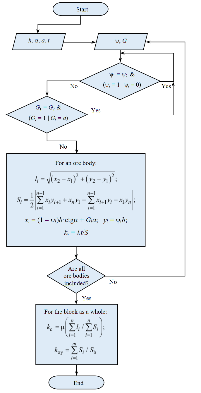
Fig.4. Block diagram of the program for calculating the dimensions geometric elements of the CSB
μ – a certain proportionality coefficient, m, in the special case μ = t
Discussion
It is justified that the key elements of geometric models of complex-structured blocks of benches are scattered continuous and dispersed ore bodies of various shapes and sizes with different physical, mechanical, and technological properties, as well as varying proportions of useful and harmful components. The Cartesian coordinates of the characteristic points of the vertices of these bodies, the lengths of the segments of the contact lines of the ore bodies with the host rocks (substandard ores), and the areas of the ore bodies on the CSB sections are the key characteristics of the geometric models of complex-structured blocks. The combination of these characteristics, together with the size of the admixture layer of substandard ores (or the layer of standard ores shipped to the dump), determines the generalized technological parameter of the CSB – an indicator of the complexity of the geological and morphological structure of the block. This parameter is used to classify complex-structured blocks of benches.
Thus, the combination of graphical representations of geological sections of typical complex-structured blocks of benches, coordinates of characteristic points of scattered continuous and dispersed ore bodies, lengths of contact lines of ore bodies with host rocks, areas of ore bodies and host rocks, which determine the mining and geological characteristics of complex-structured ore blocks of a bench, represent geometric models of CSB. They serve as an information base for creating geometric models of real complex-structured mineral deposits, allowing for the best decisions to be made regarding the economicaland environmentally friendly development of complex-structured bench blocks.
The research results can be applied, for example, at the Aktogay and Bozshakol copper deposits (Kazakhstan) and others, to ensure the sustainable operation of mining and metallurgical enterprises in a situation of systematic deterioration of the mining and geological conditions for mineral development.
Conclusion
A new modernized typology of complex-structured bench blocks has been proposed, and mining-geological models of complex-structured blocks have been improved. Geometric models of typical complex-structured bench blocks have been created, and the elements of these models have been substantiated.
A methodology has been developed for determining the numerical values of the elements of geometric models: Cartesian coordinates of characteristic points of scattered and dispersed CSB bodies, lengths of contact lines between ore bodies and host rocks (substandard ores), areas of ore bodies, rational thickness of the admixture layer of substandard ores, and mining and geological characteristics of the block. An automated system for determining these values has been created.
The combination of graphical representations of cross-sections of typical complex-structured blocks and their mining and geological characteristics constitutes a geometric model of complex-structured bench blocks.
The developed geometric models of typical complex-structured blocks serve as the basis for creating geometric models of real CSB and developing models of CSB in a blasted state. They allow:
- Predict and standardize ore losses and dilution during the development of complex structural blocks.
- Develop a methodology for standardizing ore losses and dilution for real CSB.
- Select rational parameters for technologies for extracting scattered ore bodies in specific mining and geological conditions.
- Expand the use of low-waste technologies in the exploitation of complex-structured mineral deposits.
- Improve the efficiency of using the Earth's georesources.
References
- Rakishev B.R. Development of the Bozshakol and Aktogay copper ore deposits in Kazakhstan. Gornyi zhurnal. 2019. N 1, p. 89-92 (in Russian). DOI: 10.17580/gzh.2019.01.18
- Cheban A., Sekisov G. Complex structural ore blocks and their systematization. Transbaikal State University Journal. 2020. Vol. 26. N 6, p. 43-53 (in Russian). DOI: 10.21209/2227-9245-2020-26-6-43-53
- Kushnarev P.I. Hidden losses and depletion. Zoloto i tekhnologii. 2017. N 3 (37), p. 82-86 (in Russian).
- Rakishev B.R. Mining and geological models of virtual complex ore blocks of the bench. Naukovyi visnyk Natsionalnoho hirnychoho universytetu. 2023. N 4, p. 11-17. DOI: 10.33271/nvngu/2023-4/011
- Rakishev B.R. Complete extraction of conditioned ores from complex-structured blocks due to partial admixture of substandard ores. Journal of Mining Institute. 2024. Vol. 270, p. 919-930.
- Kantemirov V.D., Titov R.S., Timohin A.V., Jakovlev A.M. Improvement of methods of accounting for increased losses and dilution of minerals during production. Mining Informational and Analytical Bulletin. 2020. N 3-1, p. 453-464 (in Russian). DOI: 10.25018/0236-1493-2020-31-0-453-464
- Rakishev B.R. Technological resources for improving the quality and completeness of use of the mineral raw materials. News of the National Academy of Sciences of the Republic of Kazakhstan. Series of geology and technology sciences. 2017. Vol. 2. N 422, p. 116-124.
- Letov N., Velivela P.T., Siyuan Sun, Yaoyao Fiona Zhao. Challenges and Opportunities in Geometric Modeling of Complex Bio-Inspired Three-Dimensional Objects Designed for Additive Manufacturing. Journal of Mechanical Design. 2021. Vol. 143. Iss. 12. N 121705. DOI: 10.1115/1.4051720
- Ammad M., Misro M.Y., Abbas M., Majeed A. Generalized Developable Cubic Trigonometric Bézier Surfaces. Mathematics. 2021. Vol. 9. Iss. 3. N 283. DOI: 10.3390/math9030283
- Ameer M., Abbas M., Miura K.T. et al. Curve and Surface Geometric Modeling via Generalized Bézier-like Model. Mathematics. 2022. Vol. 10. Iss. 7. N 1045. DOI: 10.3390/math10071045
- Korotkiy V.A., Usmanova E.A. Bicubic Surface on a Fixed Frame: Calculation and Visualization. Scientific Visualization. 2023. Vol. 15. N 2, p. 45-65 (in Russian). DOI: 10.26583/sv.15.2.05
- Verbilo P.E., Iovlev G.A., Petrov N.E., Pavlenko G.D. Application of information modeling technologies for surveying support of mining operations. Mining Informational and Analytical Bulletin. 2022. N 6-2, p. 60-79 (in Russian). DOI: 10.25018/0236_1493_2022_62_0_60
- Stupnik M., Kalinichenko O., Kalinichenko V. et al. Choice and substantiation of stable crown shapes in deep-level iron ore mining. Mining of Mineral Deposits. 2018. Vol. 12. Iss. 4, p. 56-62. DOI: 10.15407/mining12.04.056
- Kim H.-S., Chung C.-K., Kim J.-J. Three-dimensional geostatistical integration of borehole and geophysical datasets in developing geological unit boundaries for geotechnical investigations. Quarterly Journal of Engineering Geology and Hydrogeology. 2018. Vol. 51. N 1, p. 79-95. DOI: 10.1144/qjegh2016-012
- Hekmatnejad A., Emery X., Alipour-Shahsavari M. Comparing linear and non-linear kriging for grade prediction and ore/waste classification in mineral deposits. International Journal of Mining, Reclamation and Environment. 2019. Vol. 33. Iss. 4, p. 247-264. DOI: 10.1080/17480930.2017.1386430
- Afeni T.B., Akeju V.O., Aladejare A.E. A comparative study of geometric and geostatistical methods for qualitative reserve estimation of limestone deposit. Geoscience Frontiers. 2021. Vol. 12. Iss. 1, p. 243-253. DOI: 10.1016/j.gsf.2020.02.019
- Dumakor-Dupey N.K., Arya S. Machine Learning – A Review of Applications in Mineral Resource Estimation. Energies. 2021. Vol. 14. Iss. 14. N 4079. DOI: 10.3390/en14144079
- Zerzour O., Gadri L., Hadji R. et al. Geostatistics-Based Method for Irregular Mineral Resource Estimation, in Ouenza Iron Mine, Northeastern Algeria. Geotechnical and Geological Engineering. 2021. Vol. 39. Iss. 5, p. 3337-3346. DOI: 10.1007/s10706-021-01695-1
- Afeni T.B., Lawal A.I., Adeyemi R.A. Re-examination of Itakpe iron ore deposit for reserve estimation using geostatistics and artificial neural network techniques. Arabian Journal of Geosciences. 2020. Vol. 13. Iss. 14. N 657. DOI: 10.1007/s12517-020-05644-9
- Kantemirov V.D., Iakovlev A.M., Titov R.S. Applying geoinformation technologies of block modelling to improve the methods of assessing quality indicators of minerals. News of the Higher Institutions. Mining Journal. 2021. N 1, p. 63-73 (in Russian). DOI: 10.21440/0536-1028-2021-1-63-73
- Fedorenko P.I., Peremetchik A.V., Podoinitsyna T.A. Forecasting and multifactorial geometrization of quality indicators of iron ore deposits based on heuristic methods. Vіsnik Krivorіzkogo natsіonalnogo unіversitetu. 2017. Iss. 45, p. 70-77.
- Nan Li, Xianglong Song, Cangbai Li et al. 3D Geological Modeling for Mineral System Approach to GIS-Based Prospectivity Analysis: Case Study of an MVT Pb-Zn Deposit. Natural Resources Research. 2019. Vol. 28. Iss. 3, p. 995-1019. DOI: 10.1007/s11053-018-9429-9
- Braga F.C.S., Rosiere C.A., Santos J.O.S. et al. Depicting the 3D geometry of ore bodies using implicit lithological modeling: An example from the Horto-Baratinha iron deposit, Guanhães block, MG. REM – International Engineering Journal. 2019. Vol. 72. Iss. 3, p. 435-443. DOI: 10.1590/0370-44672018720167
- Lishchuk V., Lund C., Lamberg P., Miroshnikova E. Simulation of a Mining Value Chain with a Synthetic Ore Body Model: Iron Ore Example. Minerals. 2018. Vol. 8. Iss. 11. N 536. DOI: 10.3390/min8110536
- De-Yun Zhong, Li-Guan Wang, Jin-Miao Wang. Combination Constraints of Multiple Fields for Implicit Modeling of Ore Bodies. Applied Sciences. 2021. Vol. 11. Iss. 3. N 1321. DOI: 10.3390/app11031321
- Nan Li, Cangbai Li, Wenkai Chu et al. Uncertainty Visualisation of a 3D Geological Geometry Model and Its Application in GIS-Based Mineral Resource Assessment: A Case Study in Huayuan District, Northwestern Hunan Province, China. Journal of Earth Science. 2021. Vol. 32. Iss. 2, p. 358-369. DOI: 10.1007/s12583-021-1434-y
- Zhuo Jia, Sixin Liu, Siyuan Cheng et al. Modeling of Complex Geological Body and Computation of Geomagnetic Anomaly. Mathematical Problems in Engineering. 2020. Vol. 2020. N 9839606. DOI: 10.1155/2020/9839606
- Jinmiao Wang, Hui Zhao, Lin Bi, Liguan Wang. Implicit 3D Modeling of Ore Body from Geological Boreholes Data Using Hermite Radial Basis Functions. Minerals. 2018. Vol. 8. Iss. 10. N 443. DOI: 10.3390/min8100443
- Lukichev S.V., Nagovitsyn O.V. Digital simulation in solving problems of surface and underground mining technologies. Gornyi zhurnal. 2019. N 6, p. 51-55 (in Russian). DOI: 10.17580/gzh.2019.06.06
- Nagovitsyn O.V. Development of mining and geological information system in the present-day situation in the Russian mining industry. Russian Mining Industry. 2023. N 5S, p. 35-40 (in Russian). DOI: 10.30686/1609-9192-2023-5S-35-40
- Lukichev S.V. Digital past, present, and future of mining industry. Russian Mining Industry. 2021. N 4, p. 73-79 (in Russian). DOI: 10.30686/1609-9192-2021-4-73-79
- Basargin A.A., Pisarev V.S. Features of modeling of objects of the geological environment in the development of solid mineral deposits using GGIS Micromine. XVII Mezhdunarodnyi nauchnyi kongress “Interekspo GEO-Sibir-2021”: Materialy Mezhdunarodnoi nauchnoi konferentsii “Geodeziya, geoinformatika, kartografiya, marksheideriya”, 19-21 maya 2021, Novosibirsk, Rossiya. Novosibirsk: Sibirskii gosudarstvennyi universitet geosistem i tekhnologii, 2021. Vol. 1, p. 100-110 (in Russian). DOI: 10.33764/2618-981X-2021-1-100-110
- Axler S. Linear Algebra Done Right. Springer, 2024, p. 407. DOI: 10.1007/978-3-031-41026-0