
Results of large-scale ground magnetic survey on the Broknes Peninsula (Larsemann Hills, Princess Elizabeth Land, East Antarctica)
- 1 — Ph.D. Associate Professor Empress Catherine II Saint Petersburg Mining University ▪ Orcid ▪ Elibrary ▪ Scopus ▪ ResearcherID
- 2 — Ph.D. Associate Professor Empress Catherine II Saint Petersburg Mining University ▪ Orcid
- 3 — Leading Engineer Empress Catherine II Saint Petersburg Mining University ▪ Orcid
Abstract
In the course of seasonal work of the 70th Russian Antarctic expedition (RAE) in 2024-2025, as part of the field geological and geophysical studies by researchers of Empress Catherine II Saint Petersburg Mining University on the Broknes Peninsula (Larsemann Hills, East Antarctica), areal ground magnetic survey was accomplished at 1:10,000 scale. The study area is characterized by a high exposure degree of Cambrian and Precambrian rocks with localization in certain parts of magnetite-bearing complexes. The work included experimental and methodological research, surveying in two modes (discrete and continuous) with data quality control as well as subsequent processing and initial interpretation of the results. A detailed map of the total magnetic intensity covering an area of 17.5 km2 and maps of the field transformations – vertical derivative, absolute horizontal gradient, etc., were compiled. Qualitative interpretation allowed identifying morphologically homogeneous zones in the study area characterized by different features of anomalous magnetic field. Results of the studies will be used in future for geological interpretation of anomalies and compilation of the structural tectonic map of the region.
The work was accomplished under the State assignment of the Ministry of Science and Higher Education of the Russian Federation FSRW-2024-0003 (Fundamental interdisciplinary research of geological formations in Antarctica in the area of Vostok Station).
Introduction
Antarctic oasis is an area free of glaciers and permanent snow cover. Within the continent, oases make up no more than 0.03 % of the area and occur mainly at the coast [1]. Such areas are especially valuable in the studies of geological structure of the East Antarctic Plate, as they provide a rare opportunity for direct geological observations and large-scale geophysical surveys. The results of geological and geophysical studies of oases can be extrapolated to nearby areas covered by glaciers, thus giving additional information on geological structure of adjacent regions of East Antarctica [2, 3].
The Larsemann Hills are in the eastern Prydz Bay on the coast of the Cooperation Sea (Ingrid Christensen Coast, Princess Elizabeth Land). The area of the oasis was first mapped by the captain of the Norwegian expedition vessel Clarius Mikkelsen in 1935. Boundaries of the area are distinctly outlined by glacial structures: in the east, the oasis is limited by Dålk outlet glacier; in the south, by a vast glacial plateau; in the west, by the massive Polarårboken Glacier. Landscape of the oasis is formed by low hills separated by fjords and bays (Thala, Nella, Clemence, Dålkøy and Wilcock). The oasis comprises two large peninsulas – Stornes and Broknes, three small ones – Grovnes, Brattnevet, Stinear, and about 130 islands. Among the latter, relatively large islands – Fisher, Manning and McLeod (Fig.1) stand out. Research was conducted on the Broknes and Stinear peninsulas.
Elevations within the Larsemann Hills are in a narrow range, varying mainly from 0 to 120 m. The maximum elevation is associated with the Blundell Peak and is 158 m above sea level. The occurrence of folds and faults in metamorphic bedrock explains the elongated (stretched-out) morphological forms of large relief elements. There is a significant number of large (about 150) and small lakes, and snow patches are common in some cases, especially in the south of the area.
The Larsemann Hills are Antarctic Specially Managed Area N 6 [4], and the Stornes Peninsula and adjacent areas are Antarctic Specially Protected Area N 174 (a geological reserve) [5]. There are three year-round polar stations in the oasis: Progress (Russia), Zhongshan (China), Bharati (India) and one seasonal base, Law-Racoviță (Australia – Romania). Zenit runway (Russia) is a few kilometres south of the Progress Station, on an ice plateau; it is used for logistics and geophysical work by both Russian and foreign researchers [3, 6, 7].
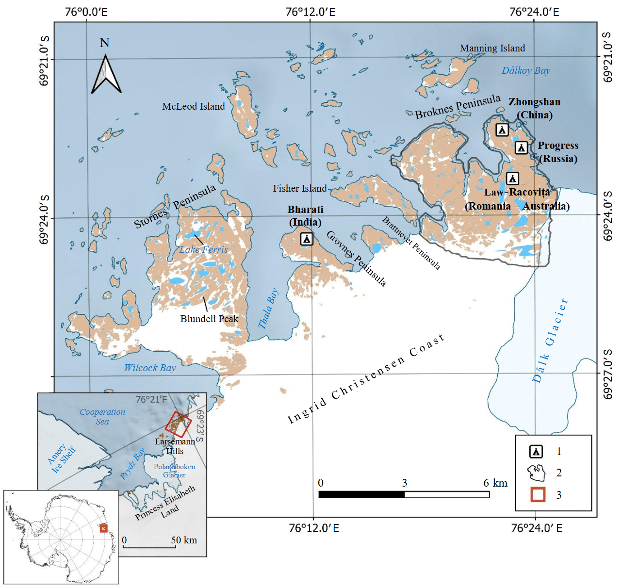
Fig.1. Location map of the Larsemann Hills and study area (inset) in the map of Antarctica.
Materials of digital database SCAR (ver. 7.0) of the international GIS project Quantarctica 3.2 were used in the compilation. From here on the coordinate system is EPSG: 4326 – WGS84
1 – research stations and field bases; 2 – outline of work area; 3 – boundaries of location map in the inset
Ice-free area is of great interest for researchers from different countries. Thus, for instance, many publications often describe the investigation of lakes that were often a source of data on climate changes in this region of East Antarctica. Bottom sediments of lakes contain information on dynamics of the ice sheet over the past millennia [8, 9]. The lakes in the eastern Broknes Peninsula provide insights into the most ancient history of bottom sediments among all surface lakes in Antarctica [4]. According to current notions, the ice sheet never advanced further than Lake Nella and did not plough out Lake Progress. For this reason, lakes at the northern end of the Peninsula are of particular value to the scientific community [4]. High-level studies of the outlet glacier and Lake Dålk were due to the fact that in 2018 a breakthrough occurred there leading to formation of a huge failure in the glacier [10-12]. Of great interest are the studies of relief and its dynamics over time [13] which allow to detect traces of glacial exaration (scratches, scars) and accumulative relief forms (moraine ridges) indicating ancient glacial activity as well as to identify zones of wind and water erosion that form micro- and mesorelief of the area.
In addition, a significant amount of work within the Larsemann Hills and on adjacent areas of Princess Elizabeth Land focuses on geophysical methods for studying features of geological structure of the region [14]. The National Centre for Earth Sciences (NCESS) of India successfully set up a permanent broadband seismological observatory in the Larsemann Hills oasis [15]. Microseismic records provide new data on tectonic evolution of East Antarctica and dynamic processes within the Earth. Based on processing and interpretation of scattered wave data, the structure of the Earth's crust was determined and Moho depth was estimated at about 37 km [16].
Earth’s crust of East Antarctica is characterized by different magnetic properties that reflect the age, lithological composition, degree of reworking, deformation, and metamorphic changes of rocks. For intracontinental area of East Antarctica covered by the ice sheet, magnetic survey data provide a unique possibility to study the geology of the basement and its structure, and also allow to presumably map the boundaries between Archean stable cratons and the Proterozoic mobile belts [17]. Unmanned aeromagnetic studies within Wilkes Land conducted for the first time in world practice under the joint project of VNIIOkeangeologia and Radar mms in the 2023-2024 season, seem to be very successful. The completed survey presented unique materials on variability of the anomalous magnetic field in the area of the Bunger Oasis and the Highjump Hills. The survey results are informative for further geological interpretation and exceed the level of research detail of the available geological materials [18].
Generalizing information on magnetic survey in Antarctica is published in the article by A.V.Golynskii and co-authors [19]. This article presents data on magnetic survey of Antarctica carried out over more than sixty years by members of the Russian and foreign expeditions, and the second version of the map of the anomalous magnetic field of Antarctica was also compiled.
During the 32nd Soviet Antarctic expedition in 1987, aeromagnetic survey was accomplished in the vicinity of the Larsemann Hills on a network with line spacing 5 km [2]; however, only four observation lines were run directly above the oasis, which did not allow an objective interpretation of the recorded magnetic anomalies on peninsula. In addition, the 1987 navigation system based on DISS-013 and a photo camera, did not ensure the necessary precision in referencing the routes.
As a result of surveying, a fragment of an intense positive anomaly was mapped which was later named the Amery lineament, one of the longest (~700 km) recorded in East Antarctica [20].
In the 2022-2023 season, aeromagnetic survey was conducted in the northwestern Princess Elizabeth Land on a network line spacing 1 km, partly covering the southern Broknes Peninsula. The purpose of this survey was to select a borehole location in the ice column for drilling and core sampling of basal ice and subglacial rocks as part of the Russian-Chinese project [3]. The project was aimed at determining the geological nature of a high-amplitude linear magnetic anomaly (Amery lineament) which extends parallel to the coast over more than 700 km from Princess Elizabeth Land to MacRobertson Land crossing the Lambert Rift zone [21].
In the course of ground studies of the anomalous magnetic field in the area of the Indian station Bharati conducted in 2007, 410 physical observations were made, and the recorded positive anomalies were confined to occurrence zones of garnet-magnetite-biotite gneisses [22].
Thus, a detailed magnetic survey in the area of the Broknes Peninsula was not yet conducted despite a potentially high geological information content of this geophysical research method. Accomplishment of such work seems to be an urgent task for studying the nature of the magnetic field anomalies above the basement rocks, mineralization zones, and intrusive formations of different composition.
Geological structure of the study area
The Broknes Peninsula, located on the coast of the Prydz Bay within the Larsemann Hills is composed of Precambrian metamorphic rocks characteristic of East Antarctica which underwent several stages of regional metamorphism. The geological structure includes ortho- and paragneiss belonging to the amphibolite and granulite facies of metamorphism [23] and comprising the Mesoproterozoic Nella mafic-granulite, the Neoproterozoic Zhongshan gneiss and paragneiss combined in the Brattstrand sequence [24]. The latter is divided into several subformations, among which Lake Ferris metapelite, Broknes paragneiss, Gentner metapsammite and White Hill leucogneiss are distinguished [24] (Fig.2). Within the study area, orthogneiss represented by Nella mafic-granulite is mapped in the northern Mirror Peninsula, where they form individual exposures of metamorphosed mafic rocks of granulite facies of isometric shape to 500 m in plan. Metamorphic rocks are cut by dykes and stock-like bodies of Early Cambrian granitoids of the Progress complex and acidic pegmatites [24].
A Progress microgranite dyke is represented by fine-medium-grained syenogranite, ranging from pink to orange, with accessory apatite, zircon, and sillimanite. Presumably, it belong to the Progress Granite Complex. Progress granite, in turn, is widespread occurring as orange biotite (syeno) granite, the accessory minerals of which are garnet, magnetite, spinel, monazite, zircon (circa 515 Ma). White Hill leucogneiss is light-grey leucocratic gneiss (biotite, quartz, and plagioclase); cordierite and quartz symplectites, potassium feldspar veins and, rarely, garnet are observed in the Larsemann Hills. Gentner metapsammites are represented by quartz-feldspar psammites with garnet and biotite, can contain small lenses of sillimanite, spinel/magnetite and lenses of hornblende-plagioclase metabasite. Broknes paragneiss is a heterogeneous yellow garnet-bearing quartz-feldspar paragneiss with admixtures of sillimanite, spinel and magnetite. Lake Ferris metapelite is dark-coloured garnet contained, sillimanite, biotite and with variable amounts of spinel and magnetite. Rare cordierite, and leucosomes of K-feldspar to 1 cm in size are also present. Zhongshan gneiss within the Broknes Peninsula is widespread as leucocratic quartz-feldspar gneiss with veinlets of garnet veinlets and rare biotite (circa 940 Ma). Nella mafic-granulite is dark-coloured mafic-granulite consisting of orthopyroxene, clinopyroxene, and plagioclase, locally containing chlorite, with minor amounts of magnetite, biotite, titanite, and zircon (circa 1100 Ma) [24].
During field geological and geophysical studies, researchers of the Mining University discovered that dark varieties of Lake Ferris metapelite consist of aggregates of cordierite, magnetite and, to a lesser extent, biotite. Magnetite is represented by irregularly shaped segregations with a blue tarnish, which can point to an admixture of titanium in the mineral, up to formation of titanomagnetite characteristic of rocks of the granulite facies. Moreover, individual cordierite-magnetite interlayers and lenses of north-northwest strike, up to 5 m thick and extending for about a few dozens of metres were mapped in Broknes paragneiss in the central and northern parts of the Broknes Peninsula. Magnetite occurs in large amounts in metamorphosed granites of the Progress complex, which form a stock and a series of dyke-shaped bodies in the western and eastern parts of the study area. At the same time, at contacts with the host Broknes paragneiss and Lake Ferris metapelite, an increasing content of iron-containing minerals is observed.
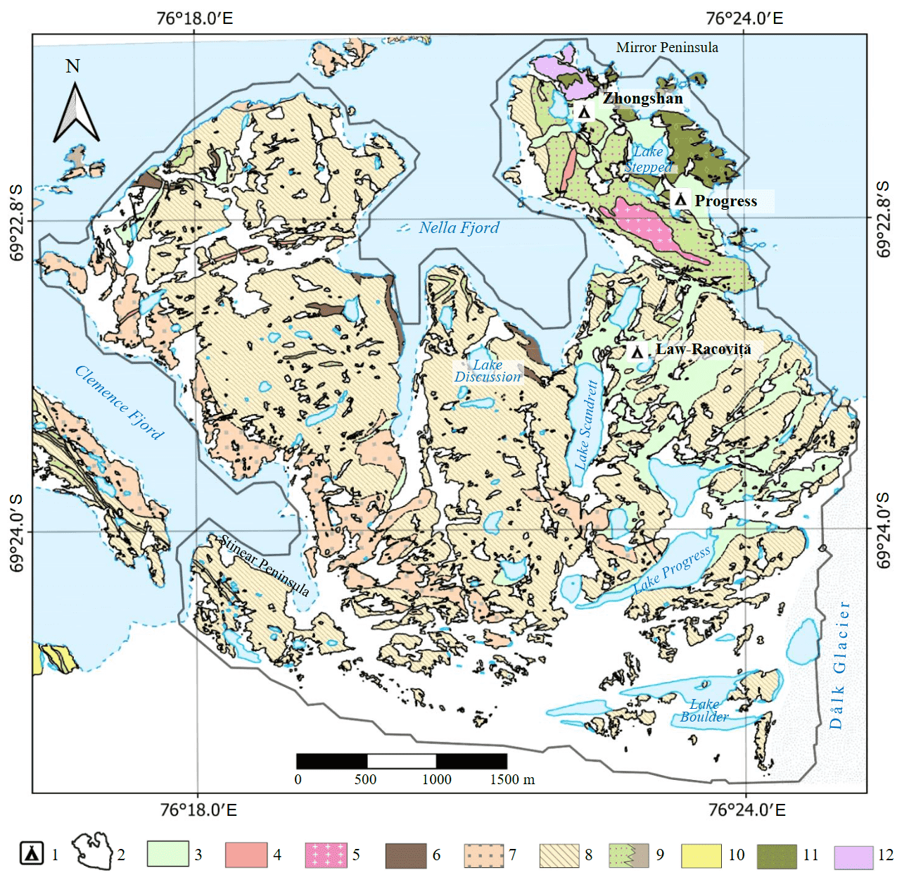
Fig.2. Geological scheme of the Broknes Peninsula and surrounding area, Larsemann Hills [24]
1 – research stations and field bases; 2 – outline of work area; 3 – loose sediments; 4 – Progress microgranite dyke; 5 – Progress granite; 6-9 – Brattstrand paragneiss sequence (6 – White Hill leucogneiss, 7 – Gentner metapsammite, 8 – Broknes paragneiss, 9 – Lake Ferris/Stüwe metapelite (Lake Stüwe metapelites are sillimanite pelites with variable amounts of cordierite, minor amounts of magnetite and spinel, isoclinal leucosomes of microcline); 10 – Blundell orthogneiss (cream-coloured garnet salic orthogneisses, locally with large crystals of K-feldspar); 11 – Zhongshan gneiss; 12 – Nella mafic-granulite
Equipment and methods of work
Seasonal work program of the field team of the Mining University on the Broknes Peninsula included a simultaneous implementation of two types of research – geological study of the area, as part of which geological survey and specialized detailed studies were conducted, as well as geophysical work including ground magnetic survey, the results of which are presented in the article.
Magnetic field was measured using three MiniMag magnetometers (Russia), two of which were applied for routine measurements along the lines, and the third one, as a magnetic variation station. Topogeodetic referencing of the results of each measurement was accomplished using a GNSS receiver built into the device; for orientation on the ground, Garmin GPSMap 66st/66sr GPS receivers (USA) were used.
Ground magnetic survey at 1:10,000 scale within the study area (Fig.3) was performed in two modifications. Continuous ground survey was accomplished along the lines oriented at an angle of 53.4° to the geographic meridian of 76°, with line spacing of 100 m, laid along the strike of the main topographic elements of the area and across the strike of the known geological structures. The recording interval was 2 s, which approximately corresponds to the distance between observation points from 1 to 3 m. Discrete – stationary multiple measurements along the lines with station spacing 100 m were made with receiving a uniform observation network.
It should be noted that labour costs in the first and second cases were approximately the same, since the same distance was covered. However, when surveying in discrete mode, the operatorʼs positioning at regular and control observation points is more precise. Each measurement was made at least three times with subsequent computation of error at each point of discrete observations.
Total number of stations in the discrete mode is 1697; in the continuous mode the database includes more than 140,000 lines, length of routes is 169 km.
Other elements of the observation methodology are standard – a magnetic variation station with 1 s recording interval, measurements at the checkpoint with all instruments of the survey team at the beginning and end of the working day.
Continuous surveying resulted in a more detailed map, as demonstrated in Fig.4 for a fragment of the map of the total magnetic intensity in the northwestern Broknes Peninsula. Maps of magnetic anomaly graphs are usually compiled using continuous records of magnetic field values along the lines; however, the authors preferred an areal analysis of contour maps with calculation of field transformations, retaining the possibility of a more detailed interpretation for individual lines.
The main stages of data processing included accounting for magnetic variations by subtracting the magnetic field value recorded by the magnetic base station from that simultaneously measured at a routine point. To calculate and introduce a correction for the systematic discrepancy between the instruments, analysis of results, convergence at the control point was performed as well as computation of standard deviations (SD) at routine and control points of discrete observations. Total number of control points in the study area was 108 (~6 % of all measurements). According to results of control observations, the SD was 1.7 nT, which allows classifying the survey results as high-precision (error below 5 nT). Mean values of magnetic induction vector modulus in the study area vary around 54,000 nT, declination and inclination of the vector are –81° and –71°, respectively. Size of the study area is 17.5 km2; therefore, the normal magnetic field within it changes slightly [25].
Construction of the grid – a digital field model in the form of a network with a uniform distribution of nodes, was performed by several methods with analysis of the grid discrepancy value with values obtained at measurement points. The optimal gridding method and step were selected – the minimum curvature method with a grid cell size 5×5 m and an interpolation distance 100 m (to fill in the unexplored areas of lakes within the study area, the grid construction zone was increased to 150 m from the nearest measurement point). The selected gridding step allowed preserving the detail of research along the lines, and the selected method ensured the absence of false anomalies between the lines, which was controlled when compiling the map. The survey area is also characterized by a small amount of interference, which is mainly represented by anthropogenic sources within the research stations and bases. At the processing stage, the anomalies of non-geological nature were rejected and are absent from the final map for interpretation and further analysis. The survey was partly not carried out within large lakes due to the lack of a stable ice cover; the field was interpolated for these areas.
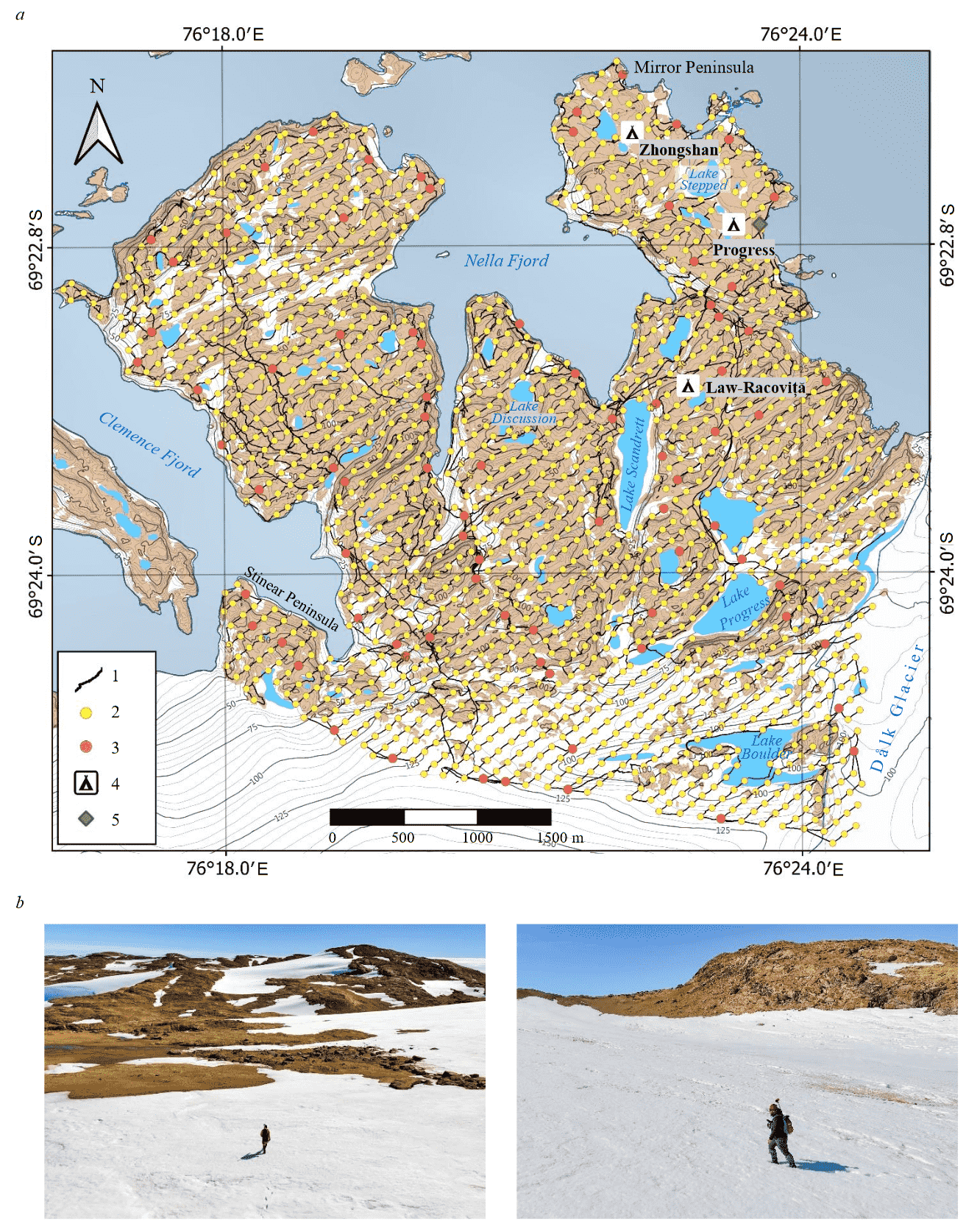
Fig.3. Scheme of actual magnetic survey data based on materials of digital database SCAR (ver. 7.0) of the international GIS project Quantarctica 3.2 (a) and field studies (b) in the Broknes Peninsula
1 – continuous survey routes; 2 – discrete measurement points; 3 – control measurement points; 4 – stations and field bases; 5 – position of magnetic base station and control point
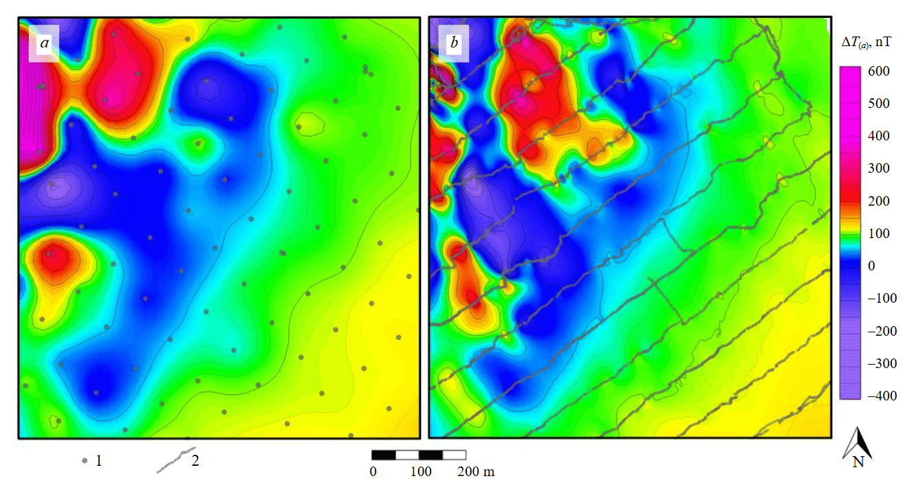
Fig.4. Fragments of total magnetic intensity (TMI) map in the northwestern Broknes Peninsula based on discrete survey data (a); based on continuous survey data (b). Major level interval is 10 nT
1 – discrete measurement points; 2 – continuous survey routes
Results
The final total magnetic intensity (TMI) map for the Broknes Peninsula is shown in Fig.5. Variation range is about 10,000 nT, but more than 80 % of the area corresponds to the range of ±500 nT. Extreme TMI values of about 2000-5000 nT were recorded between Progress and Law-Racoviță stations, in the contact area of the Progress granite, Ferris Lake metapelite, and Broknes paragneiss. The character of the TMI in the areas differs in the amplitude-frequency composition, predominant directions of anomaly axes or gradient zones. Zones of the shortest-period and most intense anomalies in the northern part of the study area in most cases correspond to exposures of magnetite-bearing rocks recorded on the surface.
For a more complete analysis of relationships between the recorded anomalies and data of the accompanying observations, mathematical transformations of the model of areal distribution of the magnetic field were performed. First of all, the vertical derivative of the field was calculated using the spectral method (Fig.6, a), emphasizing, like all differential transformations, local anomalies of different origins – geological or associated with defects in surveying and data processing. In addition, the field was reduced to the magnetic pole (RTP) (Fig.6, b), making it possible to correct the oblique induced magnetization of geological bodies, bringing it to a vertical position. Tilt derivative (TDR) was also calculated (Fig.6, c), allowing to enhance the manifestation of low-amplitude anomalies, for example, those common in the central region of the study area and not manifested in other schemes. Transformation (Fig.6, d) – values of the short-period component modulus averaged in a sliding window, is a useful field transformation for solving zoning problems, characterizing the density of local anomalies. To calculate the specified transformation, at the first stage, the shortest-period field component (to 10 m, the so-called noise component, carrying geological information [26]), is selected in the spectral region, then its absolute values are found, and the result is averaged in a sliding window with 500 m diameter. The parameters for calculating the transformation are determined empirically.
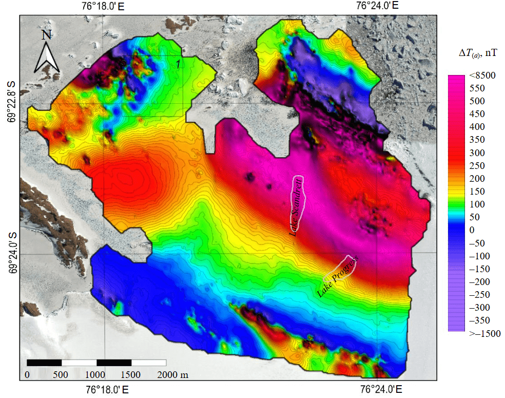
Fig.5. Total magnetic intensity (TMI) map of the Broknes Peninsula against the background of a satellite image of the area. Major level interval is 10 nT. 1 – area shown in Fig.4
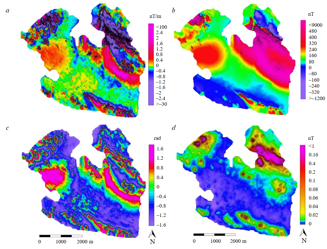
Fig.6. Schemes of TMI transformations: vertical derivative (a), reduced to the magnetic pole (RTP) (b), tilt derivative (TDR) (c), averaged modulus of short-period component of the field (d)
Discussion
Based on analysis of the TMI map and the main transformations, zoning was accomplished proceeding from the nature of magnetic anomalies manifestation. This is a version of qualitative interpretation in which the area of research is divided into several large blocks within which the signal describing changes in the magnetic field appears to be close to stationary in terms of amplitude-frequency characteristics and the strike of anomalies (Fig.7). Information on geological nature of the characteristic field anomalies is also given.
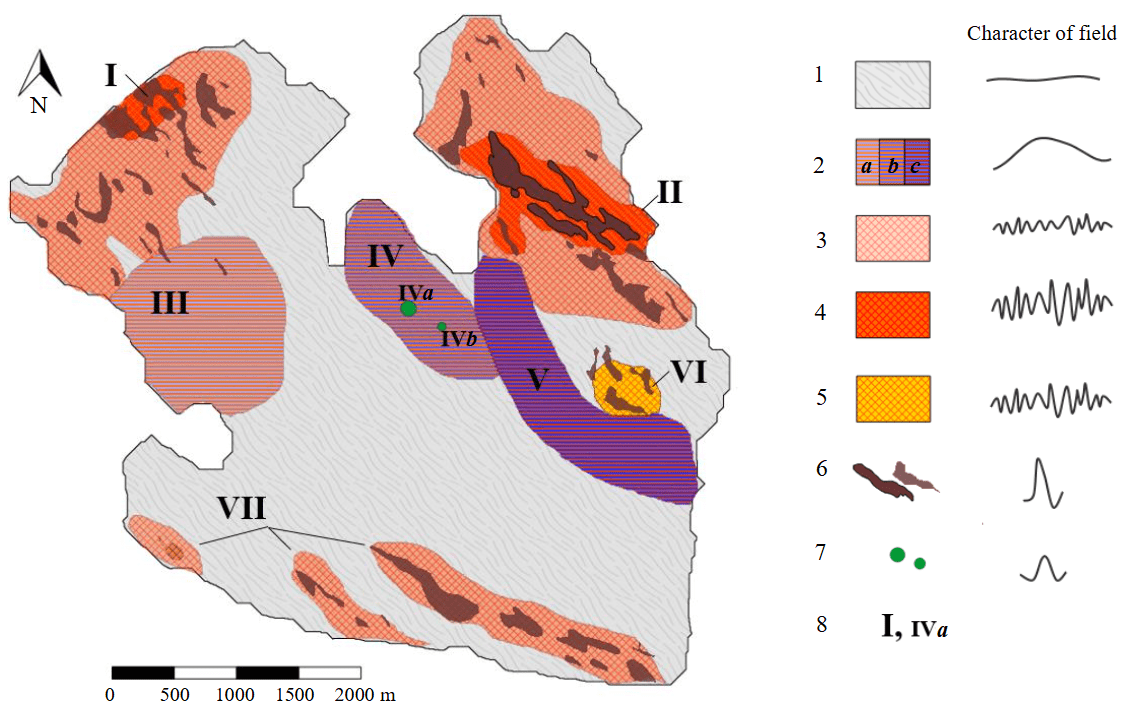
Fig.7. Zoning scheme of anomalies magnetic field
1 – zone of low-amplitude regional and local anomalies (mainly to 50 nT), geologically corresponds to the host Broknes paragneiss and Gentner metapsammite; 2 – blocks characterized by large broad anomalies with amplitude to 200 nT (a), 400 nT (b), 800 nT (c), the sources of which were not determined; 3 – zones of local anomalies (to 200 nT); 4 – blocks of intense local magnetic field anomalies (to 1000 nT) manifested by geological mapping data as exposures of magnetite-bearing rocks; 5 – block of local magnetic field anomalies (to 300 nT) manifested as an area of intense migmatization of metamorphic rocks; 6 – individual anomalies associated with near-surface magnetized vein bodies or interlayers (magnetite); 7 – isometric alternating anomalies of debatable origin; 8 – numbers of blocks and anomalies
The largest part of the peninsula is characterized by occurrence of low-amplitude (typically to 50 nT) regional and local anomalies of magnetic field. This allows assuming low values of magnetic susceptibility of the Broknes paragneiss and Gentner metapsammite as well as the absence of differences in their magnetic characteristics.
Block I lies in the northwestern part of the area, in exposure zone of magnetite-bearing rocks mapped using geological observations. There, among the dominant the Broknes paragneiss, muscovite and chamber miarolitic pegmatites containing impregnations of magnetite were observed during the work; above them, intense magnetic anomalies of various frequencies occur. The most pronounced anomalies are about 60-100 m wide, their amplitude reaching 500 nT.
Block II lies in the northeast of the area near the Antarctic year-round Progress Station. There, granite and microgranite intrusions of the Progress сomplex were mapped containing a large number of magnetite impregnations in near-contact parts. Within block II, the most pronounced high-amplitude alternating anomalies to 8000 nT are recorded. Local component of the field allows identifying individual linear anomalies about 100 m wide, stretching in the northwest direction. The extent of individual anomalies in the block exceeds 1000 m.
Block III is a relatively broad, approximately 1500 m in diameter, isometric in plan, positive anomaly to 200 nT. In all probability, the source of the anomaly is at depth, since there are no surface exposures of any magnetic rocks. There are also no convincing prerequisites for assuming lateral heterogeneity of magnetic properties of rocks composing the upper part of the section.
Block IV is characterized by a broad, arc-shaped, elongated positive anomaly, the intensity of which reaches 400 nT, in the north, corresponding to the mapped metapelites. The block is complicated by pronounced local anomalies of debatable origin. Anomaly IVa is confined to Lake Discussion, but its nature was not yet determined. Anomaly IVb corresponds to a local exposure of the so-called blue gneisses (presumably, this is Lake Ferris metapelite).
In its morphology, block V is a broad arc-shaped segment extending in the north-northwest direction; the intensity of anomalies reaches 800 nT which, most likely, correlates with a buried complex with a high magnetite content, the composition of which can be inferred from the results of complex modelling and drilling.
The considered anomaly is adjoined by the rounded block VI manifested in the local component of the anomalous magnetic field and associated with the mapped zone of intense migmatization of metamorphic rocks [27].
Three elongated anomalies, two of which can probably be traced beyond the area in the southeast under the ice sheet, are designated as number VII. These anomalies are in the field of negative ΔT(a) values, which might be a peripheral minimum of the anomaly-forming body beyond the study area or a manifestation of lateral heterogeneity of magnetic properties of rocks that compose the Broknes Peninsula. Due to the presence of the ice sheet, geological observations in the area were carried out only on individual surface exposures, which made it difficult to unambiguously interpret the TMI without performing additional types of research.
Further, it is planned to conduct research in the Broknes Peninsula both in the occurrence area of relatively regional anomalies that are not geologically manifested on the surface, and in zones dominated by local anomalies, where it is possible to conduct a detailed geological study of the area and obtain sampling data.
The main characteristics of the presumed buried magnetized bodies can be determined by geological and geophysical modelling [28, 29] confirmed by drilling with core sampling and investigation. A preliminary assessment of magnetic susceptibility and direction of magnetization of the oriented rock samples is planned [30]. Expansion of the area of detailed magnetic survey in the vicinity of the Broknes Peninsula is possible using magnetometry on unmanned aerial vehicles (UAV) [18, 31, 32].
The results of quantitative interpretation are most reliable in the presence of apriori information. Detailed geological data supplemented by geophysical methods [33], such as seismic survey [34], magnetotelluric sounding [35, 36], gamma spectrometry, gravity surveys, will reduce the ambiguity of interpretation when modelling or using other methods of interpreting magnetic anomalies [37, 38]. Continued research on Antarctic oases and adjacent areas covered by the ice sheet is the key to deciphering the history of development, geological structural, and tectonic evolution of the continent [39].
Conclusion
As part of the comprehensive geological and geophysical studies of the Broknes Peninsula in the season of the 70th Russian Antarctic expedition, ground magnetic survey of the area was accomplished at 1:10,000 scale. Total extent of measurement lines was 169 km. Geological studies were conducted simultaneously, as a result of which areal geological survey was accomplished at 1:50,000 scale, an extensive collection of representative rock samples in Broknes Peninsula was assembled, reference exposures were described and sampled with construction of 3D models using UAV, and pegmatite formations in the work area were studied in detail including those with rare mineralization. As a result of geophysical work, maps of the magnetic field anomalies and main transformations were compiled, and a preliminary geological interpretation of the identified anomalies was carried out.
Access to data
Field materials for the work are available via links:
References
- Sokratova I.N. Antarctic oases. History and results of investigations. Saint Petersburg: Arctic and Antarctic Research Institute, 2010, p. 274 (in Russian).
- Glinsky A.V., Maslova V.N., Volnukhin V.S., Golynsky D.A. Crustal Provinces of the Prince Charles Mountains Region and Surrounding Areas in the Light of Aeromagnetic Data. Antarctica. Springer, 2006, p. 83-94. DOI: 10.1007/3-540-32934-X_10
- Leitchenkov G.L., Talalay P.G., Zhang N. et al. First targeted geological sampling beneath the East Antarctic ice sheet: joint Russian-Chinese drilling project. Exploration & Protection of Mineral Resources. 2024. Special issue, p. 75-78.
- Antarctic Specially Managed Area N 6 (Larsemann Hills, East Antarctica): Revised Management Plan. Final Report of the Forty-third Antarctic Treaty Consultative Meeting, 14-24 June 2021, Paris, France. Buenos Aires: Secretariat of the Antarctic Treaty, 2021. Vol. 2. Measure 1, p. 19-53.
- Antarctic Specially Protected Area N 174 (Stornes, Larsemann Hills, Princess Elizabeth Land): Management Plan. Final Report of the Thirty-seventh Antarctic Treaty Consultative Meeting, 28 April – 7 May, Brasilia, Brasil. Buenos Aires: Secretariat of the Antarctic Treaty, 2014. Vol. 2. Measure 12, Annex, p. 185-197.
- Xiangbin Cui, Greenbaum J.S., Shinan Lang et al. The Scientific Operations of Snow Eagle 601 in Antarctica in the Past Five Austral Seasons. Remote Sensing. 2020. Vol. 12. Iss. 18. N 2994. DOI: 10.3390/rs12182994
- Polyakov S.P., Popov S.V. Research and development of technology for the construction of snow airfields for accommodating wheeled aircraft in Antarctica. Journal of Mining Institute. 2025, Vol. 273, p. 159-168.
- Grigorieva S.D., Kiniabaeva E.R., Kuznetsova M.R., Kashkevich M.P. Geophysical Methods Within The Complex of Investigations Aimed at Studying Outburst Glacial Lakes on The Example of The Progress Lake (Larsemann Hills oasis, East Antarctica). Engineering and Mining Geophysics 2021, 26-30 April 2021, Gelendzhik, Russia. European Association of Geoscientists & Engineers, 2021, p. 8 (in Russian). DOI: 10.3997/2214-4609.202152040
- Grigorieva S.D., Kuznetsova M.R., Shitov M.V. et al. Anomalous bottom topography of a small lake in the Larsemann Hills Oasis (East Antarctica). Ice and Snow. 2022. Vol. 62. N 3, p. 377-386 (in Russian). DOI: 10.31857/S2076673422030139
- Sukhanova A., Bantsev D., Popov S. et al. The current state of Lake Dålk (Larsemann Hills, East Antarctica). Polar Science. 2023. Vol. 38. N 101006. DOI: 10.1016/j.polar.2023.101006
- Mishra P., Tripathi N., Singh S.K. et al. Comprehending the surface melt characteristics, calving processes, and seasonal ice velocity of Dålk glacier in Larsemann Hills, East Antarctica. Polar Science. 2024. Vol. 42. N 101081. DOI: 10.1016/j.polar.2024.101081
- Skrypitsyna T.N., Zakharov V.G., Kiseleva A.S. et al. Topography evolution of the Dålk outlet glacier (Prydz Bay, East Antarctica) based on the data from unmanned aerial surveys performed in 2017–2019. Izvestia vuzov “Geodesy and Aerophotosurveying”. 2021. Vol. 65. N 5, p. 517-528 (in Russian). DOI: 10.30533/0536-101X-2021-65-5-517-528
- Florinsky I.V. Geomorphometric modeling and mapping of the Larsemann Hills Antarctic Oasis. InterCarto. InterGIS. GI support of sustainable development of regions in crisis conditions: Proceedings of the International conference, 12-14 September 2023, Ulan-Ude, Russia, 16-18 September 2023, Ulaanbaatar, Mongolia. Moscow: MSU, Faculty of Geography, 2023. Vol. 29. Part 1, p. 482-510 (in Russian). DOI: 10.35595/2414-9179-2023-1-29-482-510
- Lin Li, Enzhao Xiao, Xiaolong Wei et al. Crustal Imaging across the Princess Elizabeth Land, East Antarctica from 2D Gravity and Magnetic Inversions. Remote Sensing. 2023. Vol. 15. Iss. 23. N 5523. DOI: 10.3390/rs15235523
- Padma Rao B, Krishna Jha, Suresh Kumar Thatikonda. A broadband seismological observatory at Larsemann Hills, Antarctica: Noise characteristics and data quality. Polar Science. 2023. Vol. 38. N 100970. DOI: 10.1016/j.polar.2023.100970
- Rao B.P. Imaging of crustal structure beneath the Larsemann Hills, Antarctica using scattered wave technique – First Results. Polar Science. 2023. Vol. 38. N 100980. DOI: 10.1016/j.polar.2023.100980
- Golynsky A.V. Magnetic Anomalies in East Antarctica: A Window on Major Tectonic Provinces and Their Boundaries. Antarctica: A Keystone in a Changing World: Online Proceedings of the 10th International Symposium on Antarctic Earth Sciences, 26 August – 1 September 2007, Santa Barbara, CA, USA. U.S. Geological Survey and U.S. National Academy, 2007. USGS OF-2007-1047, Short Research Paper 006. DOI: 10.3133/of2007-1047.srp006
- Simakov A.E., Gutorov F.G., Leitchenkov G.L. et al. Results of aeromagnetic survey using unmanned aerial system at the Bunger Hills and Highjump Archipelago, Wilkes Land, East Antarctica. Journal of Mining Institute. 2025. Vol. 273, p. 108-122.
- Golynsky A.V., Ferraccioli F., Hong J.K. et al. New Magnetic Anomaly Map of the Antarctic. Geophysical Research Letters. 2018. Vol. 45. Iss. 13, p. 6437-6449. DOI: 10.1029/2018GL078153
- Golynsky A.V., Alyavdin S.V., Masolov V.N. et al. The composite magnetic anomaly map of the East Antarctic. Tectonophysics. 2002. Vol. 347. Iss. 1-3, p. 109-120. DOI: 10.1016/S0040-1951(01)00240-2
- Golynsky A.V., Golynsky D.A., von Frese R.R.B. Compiling ship and airborne measurements for the Antarctic’s second-generation magnetic anomaly map. Russian Journal of Earth Sciences. 2022. Vol. 22. N 3. N ES3007. DOI: 10.2205/2022ES000801
- Reddy C.D., Dhar A. Magnetic anomaly map for Bharati promontory, Larsemann Hills, East Antarctica. Current Science. 2008. Vol. 94. N 6, p. 715-717.
- Shi Zong, Yingchun Cui, Liudong Ren et al. Geochemical Characteristics, Zircon U-Pb Ages and Lu-Hf Isotopes of Pan-African Pegmatites from the Larsemann Hills, Prydz Bay, East Antarctica and Their Tectonic Implications. Minerals. 2023. Vol. 14. Iss. 1. N 55. DOI: 10.3390/min14010055
- Geology of the Larsemann Hills. Princess Elizabeth Land. Antarctica. 1:25000 scale. First Edition. Canberra: Geoscience Australia, 2007.
- Brown W., Beggan C., Cox G., Macmillan S. The new WMM2020 and IGRF-13 models, and a retrospective analysis of IGRF secular variation. EGU General Assembly 2020, 4-8 May 2020. N EGU2020-9775. DOI: 10.5194/egusphere-egu2020-9775
- Petrov A.V. Technology of evaluation and analysis of noise components of geophysical fields. Voprosy teorii i praktiki geologicheskoi interpretatsii gravitatsionnykh, magnitnykh i elektricheskikh polei: Sbornik nauch-nykh trudov po materialam 46-i sessii Mezhdunarodnogo nauchnogo seminara im. D.G.Uspenskogo, 20-25 yanvarya 2019, Perm, Rossiya. Perm: Gornyi institut UrO RAN, 2019. Iss. 1 (46), p. 297-299 (in Russian).
- Xuanhua Chen, Rongbao Jiang, Jinglin Wan et al. Cenozoic Exhumation of Larsemann Hills, East Antarctica: Evidence from Apatite Fission-track Thermochronology. Acta Geologica Sinica – English Edition. 2010. Vol. 84. Iss. 2, p. 306-320. DOI: 10.1111/j.1755-6724.2010.00142.x
- Egorov A.S., Kalinin D.F., Sekerina D.D. Geotectonic model of the deep structure of the Zmeinogorsky ore district of Rudny Altai according to geological interpretation of geophysical survey complex. Bulletin of the Tomsk Polytechnic University. Geo Assets Engineering. 2024. Vol. 335. N 8, p. 148-160 (in Russian). DOI: 10.18799/24131830/2024/8/4431
- Martyshko P.S., Fedorova N.V., Rublev A.L. Results of Modeling Sources of Magnetic Anomalies in the Earth’s Crust in the Middle Urals. Doklady Earth Sciences. 2022. Vol. 507. Part 2, p. 1107-1111. DOI: 10.1134/S1028334X22600980
- Lowe M., Jordan T., Ebbing J. et al. Comparing geophysical inversion and petrophysical measurements for northern Victoria Land, Antarctica. Geophysical Journal International. 2024. Vol. 239. Iss. 1, p. 276-291. DOI: 10.1093/gji/ggae272
- Sadykova Z.I., Movchan I.B., Yakovleva A.A., Goglev D.A. Technology for integrated geological and geophysical interpretation of data obtained using UAVS on the example of a site in the Murmansk region. Geologiya i poleznye iskopaemye Zapadnogo Urala. 2023. Iss. 6 (43), p. 161-169 (in Russian).
- Movchan I.B., Shaygallyamova Z.I., Yakovleva A.A. Identification of structural control factors of primary gold ore occurrences by method of unmanned aeromagnetic survey by the example of the Neryungrisky district of Yakutia. Journal of Mining Institute. 2022. Vol. 254, p. 217-233. DOI: 10.31897/PMI.2022.23
- Litvinenko V.S., Trushko V.L. Modelling of geomechanical processes of interaction of the ice cover with subglacial Lake Vostok in Antarctica. Antarctic Science. 2025. Vol. 37. N 1, p. 39-48. DOI: 10.1017/S0954102024000506
- Bolshunov A.V., Vasilev D.A., Dmitriev A.N. et al. Results of complex experimental studies at Vostok station in Antarctica. Journal of Mining Institute. 2023. Vol. 263, p. 724-741.
- Davydkina T.V., Yankilevich A.A., Naumova A.N. Specifics of magnetotelluric studies in Antarctica. Journal of Mining Institute. 2025. Vol. 273, p. 80-93.
- Murthy D.N., Veeraswamy K., Harinarayana T. et al. Electrical structure beneath Schirmacher Oasis, East Antarctica: a magnetotelluric study. Polar Research. 2013. Vol. 32. N 17309. DOI: 10.3402/polar.v32i0.17309
- Kalinin D.F., Dolgal A.S., Voroshilov V.A. Probabilistic Analysis of Geological and Structural Prospects for Oil and Gas Potential in Western Yakutia Using Three-Dimensional Empirical Mode Decomposition of Potential Fields. Georesources. 2024. Vol. 26. N 2, p. 53-68 (in Russian). DOI: 10.18599/grs.2024.2.6
- Talovina I.V., Mangal F., Smuk G.V., Krikun N.S. Interpretation of geological and geophysical data for studying deep structure of the Kabul massif. Gornyi zhurnal. 2024. N 9, p. 68-77. DOI: 10.17580/gzh.2024.09.11
- Talovina I.V., Babenko I.A., Ilalova R.K., Duryagina A.M. Olivine – spinel geothermometry – Indicator of formation identity of rocks and a basis for geodynamic reconstructions in Antarctica. Gornyi Zhurnal. 2024. N 9, р. 77-82 (in Russian).DOI: 10.17580/gzh.2024.09.12