
On the similarity of deep structure of the basement and genesis of depressions on the eastern flank of East Antarctic and in Lake Baikal area
- 1 — Ph.D., Dr.Sci. Head of Department Empress Catherine II Saint Petersburg Mining University ▪ Orcid
- 2 — Ph.D. Chief Specialist Gazpromneft-Snabzhenie LLC ▪ Orcid
- 3 — Postgraduate Student Empress Catherine II Saint Petersburg Mining University ▪ Orcid
- 4 — Ph.D. Professor China University of Geosciences ▪ Orcid
- 5 — Head of Department Arctic and Antarctic Research Institute ▪ Orcid
- 6 — Ph.D. Associate Professor Empress Catherine II Saint Petersburg Mining University ▪ Orcid
- 7 — Chief Executive Officer Empress Catherine II Saint Petersburg Mining University ▪ Orcid
Abstract
The article analyses the results of geophysical studies of rift structures in East Antarctic, direct geological surveying of which is impossible due to a thick ice sheet. A model is proposed for the formation of Lake Vostok depression suggesting its emplacement within the regional transtensional zone. The Lake basin includes the southern longitudinal graben forming along the main shear and the northwestern basin, which is estimated as a pull-apart structure. Based on results of the gravity and magnetic field interpretation proposed in the article, the identification and parameters of the interblock suture zone in the basement of the coastal part of the subglacial Lake Vostok are substantiated. Similarities in the structure of the Earth’s crust of regional and local structures containing Lakes Vostok and Baikal have been recorded for a large number of features: spatial correlation with position of regional shear zones; geniculate morphology of lake basins composed of linear longitudinal depressions parallel to direction of the shear zone and depressions controlled by diagonal fault displacements; relief of adjacent structures; steepness of coasts; high seismicity with earthquakes localized along the main axes of fault displacements as well as the Earth’s crust structure of geostructures controlling these basins. The formation model of rift structures of East Antarctic localized along subparallel shear zones is presented. To explain the geodynamic nature of rift systems, the model of the upper mantle convective cell is used. The Vostok, Scott, Aurora, Concordia, Adventure, Wilkes, and Astrolabe depressions form an extensive tectonic zone approximately 2,000 km long and 1,500 km wide. Tectonic schemes showing localization of the East Antarctic rift system as well as depressions of the Mesozoic West Transbaikal rift area and the Cenozoic Baikal-Stanovoi rift zone are presented.
None
Introduction
A.P.Kapitsa and colleagues in 1996 [1] were among the first experts to declare the rift nature of Lake Vostok and the comparability of this structure in terms of localization conditions with similar formations in Lake Baikal area. In 2005, G.L.Leichenkov and colleagues [2] identified an extensive rift system of Mesozoic origin in the Antarctic extending from the Prydz Bay of the Commonwealth Sea along the Lambert Glacier deep into the continent. A separate link in this system could be the graben of Lake Vostok. In 2003, M.Studinger and co-authors [3] concluded that Lake Vostok formed as a result of minor reactivation of an overthrust within the ancient (Precambrian) continental collision zone. In 2011, F.Ferraccioli and co-authors [4] put forward an evolution model of an extensive Late Paleozoic-Mesozoic rift system comprising Lake Vostok and some other subglacial lakes in East Antarctic.
According to current concepts, Lake Vostok lies within the East Antarctic Craton, the basement of which is made up of Archean and Early Proterozoic formations aged from 3.9 to 1.6 Ba. In addition, Mesoproterozoic-Neoproterozoic mobile belts aged 1,200-1,000 and 570-520 Ma, respectively, are distinguished there [5-7]. Ice cover thickness within the Craton reaches 4 km with rare basement exposures on the surface in the coastal part of the continent.
In our constructions we proceeded from the assumption of the strike-slip rift nature of the basement of Lake basins, the emplacement of which was initiated by the Cenozoic geodynamic processes in the boundary geostructures of the corresponding continents (subduction processes in the boundary zone of West Antarctic and the Himalayan-Tibetan fold belt in Eurasia) which, from our point of view, are the source of modern tectonic destruction of lithosphere in internal zones of the ancient continent.
Methods and objects of studies
Deep structure of the Earth’s crust in the area of Lake Vostok
Previous geological and geophysical [8, 9] and remote survey and the results of scientific generalizations [10-12] were analysed. In the course of the Fourth Integrated Antarctic Expedition of the USSR Academy of Sciences (1958-1959), Soviet polar aviation pilot R.V.Robinson, having conducted visual observations, was the first to identify flat areas of the ice surface near the Vostok Station, which he called a lake [13]. Subsequently, based on results of a comprehensive analysis of materials from the Soviet seismic soundings, the British-American airborne radar surveys and satellite altimetry measurements from the 1950-1990s, this event was officially recognized as the scientific discovery of Lake Vostok [13, 14] and determined further expansion of geophysical and drilling operations [15-17].
Integrated aerogeophysical studies comprising magnetic, gravimetric, and radar surveys, were accomplished by a team of American scientists with support of the US National Science Foundation [9]. According to gravimetric data, two negative anomalies are distinguished within the Lake water area: a gravity minimum with intensity of 115 mGl corresponds to the southern depression, a negative anomaly of 90 mGl corresponds to the northern depression. According to gravimetric modelling data, an ancient sedimentary basin to 10 km thick was distinguished in the area of Lake Vostok [3]. In the magnetic field, the Lake is predominantly localized in the area of negative values. A large linear alternating-sign magnetic field anomaly is traced along the eastern coast of the Lake. The intensity of the negative part of the anomaly reaches –300 nT; of the positive one, +700 nT.
Systematic study of Lake Vostok area using reflection seismic and radar methods began in 1995 [18]. During the 2009-2013 Antarctic seasons, the Polar Marine Geological Exploration Expedition ran four experimental seismic lines in the area of Vostok Station using the refraction method [8]. Based on the presence of reflectors in the seismic section, bottom sediments were identified, the thickness of which, according to these data, was estimated from tens to two hundred meters. Such a small thickness of sediments in Lake Vostok against more than five-kilometre thickness in the Late Paleozoic-Mesozoic Lambert Rift graben, according to G.L.Leitchenkov and co-authors [8], pointed to its relatively younger age, not exceeding 34 Ma – formation time of the permanent ice sheet in the Antarctic [19].
East Antarctic is considered as a stable craton; however, its modern tectonic activity is weak. The active state of the shear zone marking the eastern tectonic boundary of the Lake is evidenced by a series of low-amplitude earthquakes confined to it, the hypocentres of which, according to earthquake catalogues, are at depths of about 10 km [3]. Contemporary, though low, seismicity of this shear zone can be a source of hydrothermal activity of the Lake [2]. The detection of sulphide materials in cores of accretionary ice is also indicative of the flow of thermal energy into the Lake.
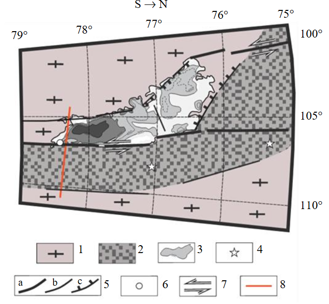
Fig.1. Geological and structural scheme of consolidated basement of subglacial Lake Vostok area
1 – complexes of ancient (AR-PR1) crust; 2 – complexes of interblock zone of Proterozoic; 3 – isobaths of Lake Vostok according to [18]; 4 – earthquake epicentres according to [3]; 5 – faults (a – main, b – secondary, c – normal faults); 6 – Vostok Station (borehole 5G); 7 – shear dislocations; 8 – calculated line
Age of the basement of Lake Vostok is widely debated. Complexes of different ages can occur there, from formations of the Archean protocraton to sediments of the ancient continental margin and Meso-Cenozoic volcanics [2]. Analysis of the composition and absolute age (by zircons) of rocks on the western coast performed on mineral inclusions from the core of accretionary ice can indicate a possible development of Neoproterozoic-Early Paleozoic sedimentary strata there [8].
According to the accomplished geophysical investigations, Lake Vostok is a geniculate depression approximately 250 km long and 50-80 km wide [8]. Average depth of the Lake is about 400 m [18]. According to the features of deep structure, the Lake depression, which has a wedge-shaped morphology in the section of the upper crust [3] is divided into two parts: the southern depression with dimensions 70 × 30 km and an average depth of 900 m; the northwestern depression with dimensions 150 × 70 km and an average depth of 300 m [18-20]. A characteristic feature of the structure of Lake depression is a rectilinear morphology of its eastern coast over more than 200 km, which confirms the conclusion about its tectonic nature. Coastal slopes are steep faults with an amplitude to 1,500 m. A sinuous western boundary allows presuming its subordinate nature and a gentler slope. In the course of our constructions, the strike-slip nature of coastal slopes was presumed.
The relief of adjacent structures west and east of Lake Vostok is very similar to that of the structures adjoining Baikal: east of Lake Vostok and west of Lake Baikal there is a flat area with a slightly dissected hilly landscape. From the west, Lake Vostok is framed by the subglacial Vostok Plateau with a mountainous landscape similar to the relief of Transbaikalia.
Modelling
Complex interpretation of geological and geophysical data (potential fields and their transformants, subglacial relief based on results of radar and seismic studies, earthquake localization) was performed using cartographic (including lineament) analysis methods under the assumption of a rift nature of Lake Vostok and its confinement to the regional left-lateral shear zone extending parallel to the Transantarctic Mountains in the direction of the outer boundary of the continent. Location of the main fault dislocations and the composition of the consolidated basement formations are shown against the background of the subglacial Lake outline and its morphology parameters (Fig.1). Seismic activity of the modelled regional shear developing along the eastern coast of the Lake can support the assumption of the shear kinematics of these dislocations. Linear morphology of the eastern coast of Lake Vostok and its steep slope, combined with indented boundary with numerous bays, isolated islands and depressions on the western coast [18] further confirms our conclusion that the main fault develops along the eastern flank of the Lake.
Analysis of depression manifestation pattern in potential fields and morphology of the Lake allows distinguishing two different types of structures. The southern depression of the Lake can be classified as a longitudinal strike-slip structure developing along the main suture. It is characterized by a size of 70 × 30 km and a depth to 1,200 m. The northwestern depression extends at an angle of 45° relative to the main shear axis and is characterized by a size of 150 × 70 km with water layer depths to 600 m [18]. The diagram is supplemented by a reference section of the upper crust constructed in the line section in the southern part of the depression as well as diagrams of the anomalous magnetic field (ΔT) and the anomalous gravity field (Δg) (Fig.2). Position of the line is highlighted in the geological structural diagram by a red line (see Fig.1).
Composition of rocks making up the basement of the study area is highly debatable. When interpreting the anomalous gravity and magnetic fields, it was noted that along the eastern flank of the Lake depression, a positive gravity field anomaly with an intensity to 50 mGal developed against the background of negative field values above the Lake and west of it. Along the same zone, a linear magnetic alternating-sign anomaly with a width of 40-50 km and an extending for hundreds of kilometres is recorded. Their joint qualitative interpretation allows associating the nature of these anomalies with the interblock suture zone framing the eastern coast of Lake Vostok.
The upper crust section was modelled using algorithms for solving the direct problem of the gravity and magnetic fields [21]. At the first stage, parameters of the interblock zone geometry were calculated using gravimetric selection. Density parameters of geological complexes of the crystalline crust were assigned with regard for the average values determined for formations of the granite-gneiss layer (2.75 g/cm3) and Proterozoic complexes of the interblock zones (2.90 g/cm3) in the course of the studies of the Baltic Shield (Fig.2). At the second stage, with geometry assigned after gravimetric data, the values of magnetic susceptibility were selected for complexes of the ancient crust and the interblock zone as well as the parameters of residual magnetization of the interblock zone JR = –2.5 A/m; inclination I = 10°; declination D = 5°. The selection ensured a match with an error between the observed and calculated curves of the gravity field of 3 mGal and the anomalous magnetic field of 15 nT.
Thus, the interpretation of the complex of geological and geophysical data allows assuming that Lake Vostok has a rift origin with left-lateral shear kinematics. The main fault is confined to the eastern flank of the Lake. This structure is a fragment of a regional shear zone which shows up in the Cenozoic tectonics. The Lake formed on the ancient Archean-Paleoproterozoic basement. However, to confirm the conclusion about the Cenozoic age of the rift zone, it is necessary to consider the current scientific versions of its genesis and to study in more detail the localization of this zone in the system of tectonic dislocations in the Antarctic. A comparison with a similar set of factual data and scientific conclusions on Lake Baikal area seems highly promising.
Geotectonic nature of depression in Lake Vostok area was considered in many scientific studies. V.N.Masolov and co-authors [22] noted the confinement of Lake Vostok to a deep fault which, in their opinion, is evidenced by linear morphology and a large size of the Lake depression. The same data indicate its relatively young age. P.Cianfarra and F.Salvini [23] linked the formation of the rift graben with development of the regional left-lateral transtensional zone along the ancient tectonic lineament in the Cenozoic.
Summarizing diverse data on specific features of the shows in geophysical fields of the Earth’s crust structure enclosing Lake Vostok, it can be stated that this is a depressional extension structure the first tens of kilometres wide, with a longitudinal segmentation and a geniculate pattern of high-amplitude faults of normal and shear kinematics. Two sub-basins participating in the modern structure of the Vostok depression have a different geodynamic nature. The southern depression forming along the main sinistral slip dislocation should be assigned to the longitudinal strike-slip depression; the northwestern depression at an angle of 45° to the main shear – to the pull-apart depression type. The Dead Sea graben is considered as a typical object of longitudinal shear zones. The second type of strike-slip pull-apart depressions is localized at an angle to the axis of the main shear. An example of this type of depressions is Death Valley [24].
Noteworthy is a significant similarity of tectonic deformations and morphology of depressions mapped in the area of Lake Vostok with these models. The shear identified along the eastern flank of the Lake is a fragment of an extensive regional shear. To confirm this conclusion, it is necessary to study in more detail the localization of such a zone in the system of tectonic dislocations in the Antarctic.
East Antarctic
The study of localization pattern of regional tectonic dislocations in East Antarctic was based on the materials of scientific generalizations carried out under the supervision of G.E.Grikurov, G.L.Leitchenkov, S.V.Popov, F.Ferraccioli, M.Studinger and other researchers. The working bank set up as layers of the geoinformation system includes data of geological mapping, remote and geophysical survey, and seismological research materials. Qualitative interpretation of these materials made it possible to substantiate some new conclusions about the geodynamic nature of regional dislocations in East Antarctic.
Crystalline basement of inner areas of East Antarctic consists of a mosaic of different Precambrian cratons and orogenic structures [4, 25]. Formation of this core of the continent occurred in the Archean – Early Proterozoic [10]. On the coastal periphery of the continent along its Indian Ocean coast and in inner zones of East Antarctic, formations of the Precambrian folded areas are mapped characterized by intense plutonic activity and a high-grade metamorphism [10].
Exposures of ancient substrate along the coast studied using isotope-geochemical dating methods, show its Archean age in the range of 4.0-2.7 Ba with later reworking. Paleoproterozoic U-Pb dates (1.8-1.6 Ba) are rare and occur on very small areas [10]. Dates of Neoproterozoic orogeny in peripheral zones of the Antarctic are associated with formation processes of the Rodinia supercontinent [26]. Mesoproterozoic and Neoproterozoic dates (1.2-0.8 Ba) of the Gamburtsev and Vostok provinces based on detrital zircons were recorded in ice cores [8]. According to data of magnetotelluric studies, lithosphere of the Antarctic Craton is characterized by a high-resistivity section (over 1,000 Ohm∙m), total thickness of which exceeds 200 km [27]. Rift destruction of continental margins after the Jurassic-Cretaceous breakup of Gondwana is evident in results of seismotomographic studies, which highlight “a thicker lithosphere in East Antarctic and a thinner lithosphere on its coast” [28]. The central area of the Craton is characterized by a uniform, elevated shear wave velocity field (excess of 2-6 % at depths less than 250 km).
East Antarctic Rift System (EARS). In East Antarctic, linear rift systems are traditionally distinguished, traced from the geographic centre of the continent to its coastline. A large number of rift structures are recorded which control the location of subglacial depressions [29]. Within the framework of this model, rift depressions are equidistant from each other at about 650 km. Many rifts inherit more ancient structural elements. The origin of the EARS is often associated with intraplate rifting in the Permian-Cretaceous period caused by the breakup of the Gondwana supercontinent (about 250 Ma) and the Cretaceous shears (about 100 Ma). Rifts show up as the maxima of the Bouguer gravity field and local minima of the magnetic field as well as in seismological data [4].
Lambert Rift. Occupies the central place among the EARS systems and serves as a peculiar axis of symmetry, on both sides of which there are six additional rift zones [4]. Total extent of the Lambert Rift system exceeds 4,000 km [29]. Morphologically, these are extended valleys 50-150 km wide and to 500 m deep below the sea level [29]. The results of gravimetric and magnetometric modelling show that the Lambert Rift encloses rather thick sedimentary deposits on top of the thinned Precambrian crust [4]. Formation of this rift system is associated with the Mesozoic phase of the continental platform extension conditions at the beginning of the split between India and Antarctic.
Strike-slip rifts on the eastern flank of the EARS. To the east of the Lambert Rift zone, a series of rifts (Vostok, Aurora, Concordia, Adventure, Wilkes) are distinguished confined to extended linear dislocations running parallel to the Transantarctic Mountains in the direction of the outer boundaries of the continent [30].
Vostok and Scott Rift systems. Lake Vostok lies along the boundary of the ancient Archean-Paleoproterozoic block and the Proterozoic suture zone. The mechanism of Cenozoic reactivation of this tectonic boundary proposed by P.Cianfarra and F.Salvini [30] is reduced to intraplate east-west shear deformation in East Antarctic. Linear zone of earthquake hypocentre localization recorded east of Lake Vostok extends in the direction of the Scott Rift. Interpretation of data on the anomalous magnetic field (ADMAP-2) [31] and subglacial relief (BedMachine) [32] using cartographic (including lineament) analysis techniques also allows identifying this linear zone as a possible continuation of Lake Vostok shear zone. The presence of such an extended zone can point to existence of a major regional discontinuity in the Earth’s crust reflecting significant horizontal movements and interaction of lithosphere plates.
Aurora and Concordia rift depressions. A characteristic feature of these depressions is a steeper slope of the eastern flank compared to the western one. Post-Mesozoic tectonic extension activity is presumed for these structures [33, 34]. The subglacial Aurora depression together with the Scott Rift forms a complex system of depressions and is considered as the eastern link of the single Aurora – Scott rift system. Earthquake epicentres are recorded in the Aurora depression [29].
The Adventure rift depression is confined to the left-lateral shear with a transtensional component. The depression reaches a thickness of about 4 km under the ice [30]. The trough extending in the north-northwest – south-southeast direction for 250 km and 60 km wide adjoins the western flank of the Wilkes subglacial basin [35]. In section, the rift has the morphology of a half-graben: the eastern slope is also steeper than the western one. Listric morphology of the Adventure fault with a vertical displacement to 2.5 km is presumed.
In article [35], based on gravity modelling, the depression is interpreted as a narrow rift basin with the crust thinned to 25 km and underlain by sediments with a total thickness to 10 km. The proposed Cenozoic extension is partly superimposed on a more ancient structure formed in the Permian to Cretaceous [30]. The offset between the old basin and the modern asymmetric depression indicates that the formation of the depression was caused by younger (Cenozoic) tectonic processes. Radar studies showed the morphology of an asymmetric graben [30]. The vertical offset along the main fault reaches 2.5 km [30]. Formation of the rift depression is related to the setting of the Meso-Cenozoic intraplate extension [3, 35] similar to the modern Baikal Rift System [30].
Wilkes Land rift systems. Glaciers to 3 km thick are underlain by deep troughs (to 2,500 m below the sea level) with steep flanks. According to radar data (RADARSAT), this region is characterized by echeloned subparallel depression systems of northwestern strike extending for 30 to 250 km. Geodynamic environment of the Wilkes subglacial basin formation and its tectonic association with evolution of the Transantarctic Mountains are the subject of discussions [30]. D.A.Golynskii and A.V.Golynskii in article [29] classify them as complex rift structures, in the section of which Permo-Triassic deposits also occur. At the same time, they could inherit the extended (> 1,200 km) Neoproterozoic system of paleorift basins, which is marked by a distinct magnetic minimum and a positive anomaly in the Bouguer reduction. Recent rift activity is manifested by the confinement of numerous earthquake foci to them.
Thus, subparallel shear structures on the eastern flank of the East Antarctic Craton, along which the Vostok, Scott, Aurora, Concordia, Adventure, and Wilkes depressions are localized, form an extensive tectonic zone of Cenozoic expansion about 2,000 km long and to 1,500 km wide, possibly, partly inheriting more ancient structural and material inhomogeneities of the Earth’s crust with an age from the Riphean to the Cretaceous. In the seismological model AN1-S [36], one of the most contrasting anomalies of low values of shear waves velocity in the upper mantle (75 and 150 km) partly corresponds to this area.
Characteristic features of depressions on the eastern flank of the EARS (Vostok, Aurora, Concordia, Adventure) are linear morphology and semi-graben geometry with a steeper eastern slope compared to the western one. Faults in the section of the upper crust have displacement amplitudes of adjacent crustal blocks of the first kilometres. Their recent tectonic activity and morphology indicate that they are caused by tectonic extension processes that affected this region in the Cenozoic. Similar asymmetries were discovered from radar data in West Antarctic [30].
Transantarctic Mountains (TAM)
They are a fundamental part of the Antarctic continent dividing it into East and West Antarctic. They extend for 3,500 km, and the relief differences within their limits reach 4 km [37]. A fragment of the regional magnetotelluric profile corresponding to the TAM shows a fundamental change in infrastructure of the section of electrical resistivity at the boundary of West and East Antarctic [27]. Geodynamic nature of the TAM is a subject of heated debate. The common feature of the alternative models by A.G.Smith and D.J.Drewry [38], P.Wannamaker and co-authors [27], W.Shen and co-authors [39], R.Granot and B.C.Storey [40] was the thermal source and rift nature of the geostructure. Formation of the mountain system during the Rossian orogeny (560-480 Ma) is associated with subduction processes [10]. The later uplift of the Transantarctic Mountains dates back to the Late Cretaceous – the first half of the Cenozoic (~55 Ma). The uplift began with formation of a regional boundary fault dividing West and East Antarctic, which activelycontinued in the second half of the Cenozoic to the present day [28].
West Antarctic
It is presumed that the folded structures of West Antarctic formed due to successive addition of blocks and island arcs to the margin of the East Antarctic Craton during subduction and collision processes from the Early Paleozoic to the Middle Mesozoic [10, 27, 41]. In the crust of the region, a collage is modelled of several (four to five) tectonic blocks with distinctive features of a continental-type lithosphere [28] separated by suture zones, rifts, and depressions. According to geophysical evidence, the inner regions of West Antarctic and the Ross Sea waters have a thinned continental crust [42] with a hot upper mantle and extensive sedimentary basins.
Formation of the TAM structure is accounted for by a combined manifestation of subduction processes along the paleo-Pacific margin of the Antarctic and rifting which led to development of magmatic arcs, accretionary complexes, and a sequence of fore-arc and back-arc basins. Some models of the TAM formation appeal to a single young “active” plume that formed simultaneously with the onset of volcanism 28-35 Ma ago [43]. Seismic tomography [44] and topographic data [45] confirm the existence of a very long-lasting mantle thermal anomaly at the coasts of West Antarctic.
West Antarctic Rift System (WARS). A vast area of extensive continental crust between the TAM and the Pacific margin stretches from the Ross Sea to the Weddell Sea and manifests itself as a topographic depression 750-1,000 km wide and about 3,000 km long [46-48]. The zone is characterized by the thinned Earth’s crust (20-30 km), development of deep rift depressions and an anomalous mantle. Horst-graben dissection of the basement led to marked differences in its occurrence depth: from exposure to the surface in horsts to subsidence by 15-16 km below the sea level [10]. A marked change in the resistivity of the Earth’s crust and upper mantle from the central ridge of the TAM to West Antarctic is interpreted as evidence of the Late Cenozoic extension activity [28, 49, 50]. At present, weak tectonic seismicity is observed within the West Antarctic Rift System [28]. Rifting pulses throughout the Cenozoic resulted in crustal thinning, subsidence, increased heat flow, and rift-related magmatic activity [40].
Volcanism
The area of modern volcanic activity (from 48 Ma to the present) [40] extends from the Antarctic Peninsula deep into West Antarctic. Along this zone, with total extent of more than 3,000 km, 138 volcanoes were identified. The eastern branch develops along the axis of the Transantarctic Belt. Magmatic activity in the Antarctic in the Mesozoic and Cenozoic resulted from the simultaneous processes of continental rifting and subduction that occurred during the final stages of the breakup of Gondwana [40]. In a number of studies, the manifestation of alkaline volcanism in West Antarctic is associated with a sudden separation and submergence of subducted plates in the Late Cretaceous, which caused a lateral and vertical flow of the warm Pacific mantle [51].
Specific features of deep structure of the Baikal-Stanovaya regional shear zone (BSRZ)
It is localized along the southern boundary of the Siberian Platform with structures of the Baikal folded area and further extends into the Stanovoi Megablock. A complex geological evolution of the southern Eastern Siberia determined the mosaic-block structure of the region. The main geological units within the study area, in addition to the Siberian Platform, are the Barguzin-Vitim, Khilok-Vitim, Shilkinskii, Stanovoi megablocks with continental crust and the Baikal-Vitim interblock suture zone (Fig.3).
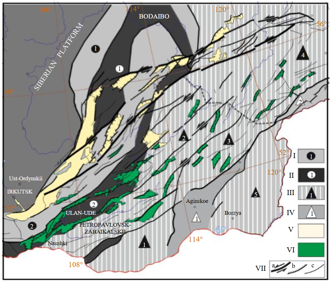
Fig.3. Geotectonic location scheme of rift depressions of Mesozoic West-Transbaikal rift area and Cenozoic Baikal-Stanovoi rift zone
I – blocks of epi-Caledonian folding: Baikal-Patom (1), Barguzin-Vitim (2); II – interblock epi-Caledonian suture zones: Baikal-Vitim (1), Khilok-Vitim (2); III – blocks of epi-Cimmerian folding: Chikoi (1), Khilok-Vitim (2), Shilkinskii (3), Stanovoi (4), Argunskii (5); IV – white triangles – interblock epi-Cimmerian zones: Onoi (1), Mongol-Okhotsk (2); V – Cenozoic rift depressions; VI – Mesozoic rift depressions; VII – faults: a – general shear dislocations, b – secondary (primitive normal fault kinematics), c – other faults of unspecified kinematics of lower ranks. Dotted line shows boundaries between structures
Data from the complex of geological and geophysical studies of the southern margin of the Siberian Platform indicate that the main volume of the Earth’s crust formed by blocks with continental-type crust [52]. In particular, according to results of electrical exploration, rigid, slightly dislocated blocks of Paleozoic microcontinents are distinguished in the section by low values of electrical resistivity from 300 to 3,000 Ohm∙m [53]. Against this background, interblock zones, including the Cenozoic zone of the Baikal Rift, exhibit abnormally low (to 50 Ohm∙m) values of electrical resistivity. The main structure of Lake Baikal is localized on the Baikal-Vitim suture zone of Caledonian age. A system of other smaller Cenozoic depressions develops in the direction of the Stanovoi Megablock [54]. In orographic terms, the rift system is a mountain system of intermountain basins and grabens with maximum elevations of 3,000-3,500 m.
Study of the morphology of active faults using data from the analysis of focal mechanisms of earthquakes indicates a dominant strike-slip fault kinematic evolution regime of both Lake Baikal, and the entire Baikal Rift System (BRS). Along with dominating shears of the south-southwest – east-northeastern orientation, a large number of feather dislocations are mapped forming a branched system at angles from 100 to 300° on both sides of faults of the highest rank. In the studies of the region [55, 56], it was shown that the dominant position in the structure of the Cenozoic faults is occupied by shears of left-lateral kinematics. The direction of lateral displacement along the faults is quite rigidly determined by their orientation. Latitudinal and northwestern faults have a left-lateral component of displacements, while the meridional and north-northeastern ones, the right-lateral component [57]. Many of the currently mapped fault dislocations experienced repeated reactivation in the Meso-Cenozoic period due to the ongoing geodynamic processes [58] covering the entire South Asian region from the convergent boundary of Hindustan to the southern framing of the Siberian Craton.
Reflection seismic and DSS allowed assessing the morphology of the rift depression and position of the main seismic boundaries. Faults in listric morphology were traced to depth both in the near-flank zone of Lake Baikal and in its internal structure of sedimentary deposits [53].
The main depression of the BSRZ is Lake Baikal, which has a characteristic geniculate morphology in plan. Within the Lake, two sub-basins are distinguished at the general level: the Southern (450 km) and the Northern (390 km) separated by the underwater Academicheskii Ridge of east-northeastern strike. Spatial orientation of the sub-basins differs. The Southern sub-basin is characterized by the southwest – northeastern strike, while the Northern one has the west-southwest – east-northeastern orientation. A detailed examination of the Southern sub-basin reveals a strong differentiation of bottom marks. Thus, in the area of the Selenga River, the depth of the Lake decreases to the first hundred meters, while south and north of this area, the average values are about 1,500 m. The area of the Selenga River delta serves as a peculiar connecting strip and divides the Southern sub-basin into two more depressions of a lower rank. The Northern sub-basin is more uniform in depth and is considered as a single rift depression.
Modern geodynamic regime of the Lake evolution is considered by many scientists as strike-slip rifting. Based on results of detailed studies of the Baikal Rift by A.V.Tevelev in article [55], a much larger number of sub-basins are modelled. Their formation and features of the structural style are due to crustal heterogeneities of different orders. But even in this classification, the Southern basin of Lake Baikal, associated with the Tunkinskii Basin, occurs along the left-lateral Kultuk shear zone of the east-northeastern strike. The eastern boundary of the sub-basin extends in the north-eastern direction across the Selenga River plain to the Primorskii strike-slip fault and the Buguldeika River. The connecting link between the Northern and Southern basins are the transition zones of the Central Basin (Buguldeiskaya, Priolkhone) with extensive manifestation of left-lateral and right-lateral shear and normal fault dislocations. The Northern basin of general north-northeastern orientation is dissected by fault zones of predominantly northeastern strike. The underwater structure of the zones is not very clear, but in the morphology of coastal structures they form clear plan steps delimited by echelon faults, so that their general kinematics is defined as strike-slip fault. As a rule, the zones are seismically active and have a shear component of movement [55]. The authors attribute only the Kicherskaya and the Upper Angara depressions northeast of the Lake to the type of pull-apart structures. According to the CDP data, it was ascertained that the sediment thickness reaches 10 km in the Southern sub-basin [59]. The basement boundary within the depression is recorded at depths of 7-8 km.
Many researchers associate the formation of the Baikal rifting zone with indentation pressure of India on the margin of the Eurasian continent. As a result, stresses are transmitted deep into the Eurasian continent through the monolithic Precambrian microcontinents and fold belts of Paleozoic-Mesozoic age framing them [60, 61]. A.V.Tevelev, developing this model, considers the relative uneven movements of the Siberian, Sea of Okhotsk and Amur plates as an additional resource for rifting [55].
The Baikal Rift System, as indicated by analysis of the modern seismicity pattern, is expanding in the east-northeastern direction deep into the Stanovoi Megablock. The accumulation area of the earthquake foci there is the forming northern boundary of the Amur plate. Faults of mixed kinematics are recorded. The change from transtensional to transpressional regime can be clearly traced in the Olekma River area. Scientific and theoretical conclusions indicate that in the future, if the current geodynamic regime on the southern edge of the Siberian Craton is maintained, the latitudinal expansion of both the BRS and the associated BSRZ will continue.
Localization features of Mesozoic depressions in West Transbaikal rift area
Localization pattern of the Mesozoic West Transbaikal Rift area was investigated by a team of scientists led by V.V.Yarmolyuk [62]. This area extending for about 1,000 km and 200-300 km wide lies at a distance of about 2,000 km from the subduction boundary of the Eurasian continent. Grabens are filled with thick strata of basalt-trachyrhyolite-pantellerite formation complexes. The age of rifting ranges from the Late Jurassic to the Early Cretaceous (155-120 Ma). Some researchers combine the depressions on the northeastern flank of the BRS into the Kichera rift basin. The largest of them are the Upper Angara, Muya, Charskaya, Tokkinskaya as well as several smaller depressions. Almost all depressions are longitudinally extended. The sizes vary from the first kilometres to several dozens of kilometres. The ratio of longitudinal to transverse dimensions reaches 10:1.
Grabens are localized along shear dislocations of east-northeastern orientation. Boundary dislocations of the grabens are either shear dislocations of the predominant strike or faults of normal kinematics oriented at an angle of 40 to 50° to them. Amplitudes of faulting in the marginal listric fault are zero at its ends and maximum in its central part, to which the depocenter of the forming half-graben is confined. In this regard, deep morphology of depressions is asymmetric. Sedimentary filling completely inherits deep morphology of depressions. Bathymetric elevations of sediments reach 2,500 m. Orientation of these dislocations agrees well with parameters of the theoretical model of the deformation ellipsoid of the left-lateral shear [63]. Thus, grabens have a very definite structural control and among classical longitudinal strike-slip rifts and depressions of pull-apart type can be distinguished among them (Fig.3).
Within the BRS, volcanics show up actively. In the general case, it is impossible to explain these volcanic manifestations by subduction processes of the active continental margin. Due to a great distance from the subduction zone (about 2,000 km), they are outside the influence zone of the convergent processes. V.V.Yarmolyuk and colleagues in article [62] relate the development of marginal magmatic belts in the Late Mesozoic magmatic province of East Asia with intraplate environments resulting from the activity of mantle plumes.
L.I.Lobkovsky [64] drew attention to the similarity of the formation mechanisms of the Cretaceous-Cenozoic igneous provinces and rift zones of Central-East Asia with similar processes in the Arctic. The same mechanism of the “return upper mantle cell” was proposed by the author to account for the geodynamic nature of rift systems in West Antarctic and the eastern flank of East Antarctic [65]. According to this model, subduction along the Pacific boundary of West Antarctic generated a return cell with ascending currents within West and East Antarctic at a distance to 2,000 km. Part of the EARS is at a greater distance from the subduction zone, and, in this case, it is necessary to take into account a possible reactivation of the existing and formation of the new rift zones in lithosphere of East Antarctic under the action of local mantle plumes.
Discussion of results
The results of gravimetric and magnetometric modelling of Lake Vostok area point to the occurrence of a regional shear of, presumably, Cenozoic age at the ancient Precambrian boundary. An important element of the system of evidence for the rift genesis and geodynamic nature of Lake Vostok is a comparison with a similar set of factual data and scientific conclusions for Lake Baikal area. These features are due to their formation under conditions of stress release within intracontinental regional left-lateral shears. The latter develop against the background of a heterogeneous basement and, thus, are segmented, distorted and form strike-slip areas of different types of extension, compression and shear settings.
Lake Vostok depression is considered as an element of the system of rift structures on the eastern flank of the East Antarctic Craton. We considered the localization features of this zone in the structure of tectonic dislocations of Antarctic. Localization pattern of structures on the eastern flank of the East Antarctic rifting zone is illustrated by the tectonic scheme of the region with earthquake epicentres* including the central part and the eastern flank of the East Antarctic Craton and the belt of the Transantarctic Mountains (Fig.4). According to current concepts, magmatic activity of the Antarctic in the Mesozoic and Cenozoic was largely determined by the simultaneity of the processes of continental rifting and subduction [40].
The results of geological and geophysical studies demonstrated an extremely wide distribution of Paleozoic-Cenozoic rift structures in the Antarctic [29]. The phase of rifting associated with the breakup of Gondwana, the beginning of which dates back to the Jurassic period, and the phase of Cenozoic rifting are distinguished [27]. Shows of the Mesozoic phase of expansion led to development of the West Antarctic Rift System, which divided the continent into the East and West Antarctic plates. This was followed by the uplift of the Transantarctic Mountains, increased magmatic activity [40] and, probably, formation of the EARS. Judging by the morphology of Lake Vostok graben, the system of boundary dislocations of which is in good agreement with parameters of the left-lateral shear deformation ellipsoid model, the graben has a well-defined structural control, and in its morphology a classical longitudinal shear rift and a pull-apart type shear depression can be distinguished.
East Antarctic Rift System includes the deep subglacial Lambert, Aurora, and Wilkes basins as well as Lake Vostok [29]. Rifts on the eastern flank of the EARS form a vast corridor with total length to 2,000 km and width to 1,500 km and can be considered as a single rift system. They include the Vostok, Scott, Aurora, Concordia, Adventure, and Wilkes rifts with a left-lateral transtensional component. They are characterized by: a linear character of outer boundaries with morphology of an asymmetric graben in vertical cross-section; listric morphology of boundary dislocations with vertical displacements of adjacent blocks in the first kilometres, given that the eastern slope of grabens is constantly steeper than the western one. Their depth in most cases exceeds 1,000 m below sea level, and the width reaches ~50 km. The extent of the structure-forming left shears with a transtensional component reaches many hundreds of kilometres [30]. It is presumed that rift expansion continued throughout the Cenozoic. Weak tectonic seismicity points to modern tectonic activity of these dislocations [28, 49].
The above-substantiated conclusions about the basement structure of Lake Vostok depression allow assuming that the main rift structures on the eastern flank of the EARS were reactivated using rheologically weakened older (epi-Baikalian and younger) sutures. Analysing the pattern of spatial arrangement of the rift zone on the eastern flank of the EARS and the geometry of rifts closing on regional shear dislocations, it is possible to record the features of similarity with the Neogene-Quaternary structures of the Baikal rifting zone and the West Transbaikal rifting area of the Late Mesozoic volcanic province in East Asia identified by V.V.Yarmolyuk in his article [62]. The development of this idea is the model by A.A.Baranov and L.I.Lobkovsky [66], which links the resumption of rifting in the Cenozoic with formation of a “return flow in the upper mantle”. This interesting mechanism was first proposed to substantiate the mechanism of Cenozoic evolution of the Arctic [65]. It is based on the idea of development of the upper mantle convection beneath the continent caused by subduction of the Pacific lithosphere under the Eurasian and North American lithospheric plates. The essence of this model is that the cold substance plunging in the subduction zones and reaching the transition zone between the upper and lower mantle, passes into an extensive horizontal layer of cold mantle substance, which extends far (about 2,000 km) beneath the Eurasian continent. This ensures the development of an upper mantle convection cell. The lower horizontal branch moves along the transition zone between the lower and the upper mantle, and the upper one forms a return flow of substance beneath the lithosphere leading to stretching of the continental lithosphere, rifting and the associated magmatism [65]. This model was efficiently adapted by A.A.Baranov and L.I.Lobkovsky to explain the formation conditions of the Cenozoic rift structures in the Antarctic [66].
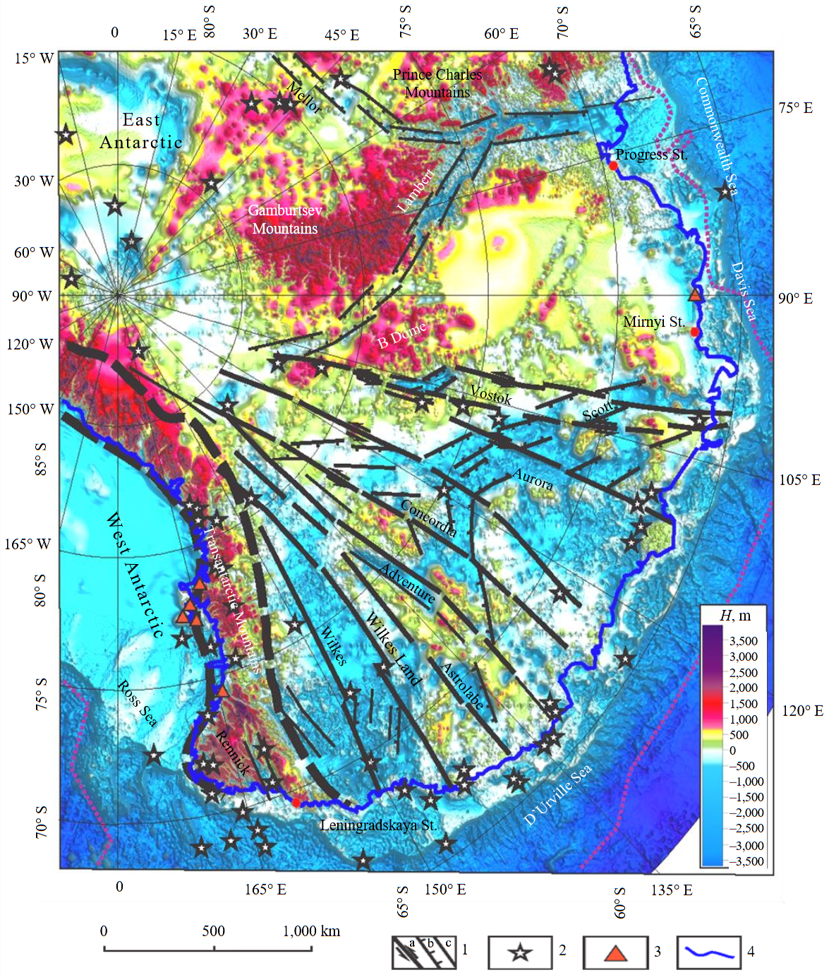
Fig.4. Tectonic scheme of evolution of the East Antarctic rift system using the map of subglacial relief [11]
1 – faults: shear dislocations (a), normal faults (b), other faults (c); 2 – earthquake epicenters; 3 – volcanoes; 4 – coastline
Conclusion
A comparative analysis of specific features of deep structure of the Earth’s crust of regional and local structures enclosing lakes Vostok and Baikal made it possible to record their similarity in a large number of features: spatial coordination with position of regional shear zones, geniculate morphology of lake basins consisting of two types of sub-basins (linear longitudinal depressions parallel to direction of the shear zone and depressions controlled by diagonal normal-fault dislocations); relief of adjacent structures; steepness of coasts; high seismicity with earthquakes localized along the main shear dislocations; structure of the Earth’s crust of geostructures controlling these basins.
A wide range of geophysical and remote sensing studies of Lake Vostok area indicates that the Lake depression has a rift origin. The main fault localized along the eastern flank of the Lake, is a fragment of a regional shear zone. It comprises two sub-basins of different geodynamic nature: a longitudinal strike-slip depression localized along the main shear axis and a pull-apart depression oriented at an angle of 45° to the main axis.
Application of the mechanism of return upper mantle convective cell provides an explanation for the development of subglacial volcanoes and Cenozoic activation of rifts in West and East Antarctic. The development of ascending currents of the “return cell” under the central part of West Antarctic and in East Antarctic at a distance to 2,000 km could lead to reactivation of the existing and formation of the new rift zones in lithosphere of East Antarctic.
This mechanism, in our opinion, can explain the phenomenon of Cenozoic rifting on the eastern flank of the EARS including the subglacial depressions of Vostok, Scott, Aurora, Concordia, Adventure, and Wilkes.
References
- Kapitsa A.P., Ridley J.K., Robin G. de Q. et al. A large deep freshwater lake beneath the ice of central East Antarctica. Nature. 1996. Vol. 381. Iss. 6584, p. 684-686. DOI: 10.1038/381684a0
- Leichenkov G.L., Belyatskii B.V., Popkov A.M., Popov S.V. Geological nature of subglacial Lake Vostok in East Antarctic Materialy glyatsiologicheskikh issledovanii. 2005. Iss. 98, p. 81-91 (in Russian).
- Studinger M., Karner G.D., Bell R.E. et al. Geophysical models for the tectonic framework of the Lake Vostok region, East Antarctica. Earth and Planetary Science Letters. 2003. Vol. 216. Iss. 4, p. 663-677. DOI: 10.1016/S0012-821X(03)00548-X
- Ferraccioli F., Finn C.A., Jordan T.A. et al. East Antarctic rifting triggers uplift of the Gamburtsev Mountains. Nature. 2011. Vol. 479. Iss. 7373, p. 388-392. DOI: 10.1038/nature10566
- Abdrakhmanov I.A., Gulbin Y.L., Skublov S.G., Galankina O.L. Mineralogical Constraints on the Pressure-Temperature Evolution of Granulites in the Bunger Hills, East Antarctica. Minerals. 2024. Vol. 14. Iss. 5. N 488. DOI: 10.3390/min14050488
- Gulbin Yu.L., Abdrakhmanov I.A., Gembitskaya I.M., Vasiliev E.A. Oriented Microinclusions of Al–Fe–Mg–Ti Oxides in Quartz from Metapelitic Granulites of the Bunger Hills, East Antarctica. Geology of Ore Deposits. 2023. Vol. 65. N 7, p. 656-668. DOI: 10.1134/S1075701523070048
- Mikhalsky E.V., Tkacheva D.A., Skublov S.G. et al. Low-grade Sandow Group metasediments of the Denman Glacier area (East Antarctica): Chemical composition, age and provenance from U–Pb detrital zircon data, with some palaeotectonic implications. Polar Science. 2020. Vol. 26. N 100587. DOI: 10.1016/j.polar.2020.100587
- Leitchenkov G.L., Antonov A.V., Luneov P.I., Lipenkov V.Ya. Geology and environments of subglacial Lake Vostok. Philosophical Transactions of the Royal Society A. 2016. Vol. 374. Iss. 2059. N 20140302. DOI: 10.1098/rsta.2014.0302
- Studinger M., Bell R.E., Karner G.D. et al. Ice cover, landscape setting, and geological framework of Lake Vostok, East Antarctica. Earth and Planetary Science Letters. 2003. Vol. 205. Iss. 3-4, p. 195-210. DOI: 10.1016/S0012-821X(02)01041-5
- Grikurov G.E., Leitchenkov G.L., Mikhalsky E.V. Antarctic Tectonic Evolution in the light of modern geodynamic concepts. Structure and Evolution of the Lithosphere. Moscow: Paulsen Editions, 2010, p. 91-110 (in Russian).
- Lukin V.V., Markov A.N. Hypothesis of Tectonic Preglacial Genesis of the Basin and Water Body of Antarctica’s Lake Vostok. Geography and Natural Resources. 2024. Vol. 45. N 2, p. 192-201. DOI: 10.1134/S1875372824700264
- Litvinenko V.S. Foreword: Sixty-year Russian history of Antarctic sub-glacial lake exploration and Arctic natural resource development. Geochemistry. 2020. Vol. 80. Iss. 3. N 125652. DOI: 10.1016/j.chemer.2020.125652
- Zotikov I.A. The Antarctic Subglacial Lake Vostok. Glaciology, Biology and Planetology. Springer, 2006, p. 139. DOI: 10.1007/3-540-37723-9
- Ridley J.K., Cudlip W., Laxon S.W. Identification of subglacial lakes using ERS-1 radar altimeter. Journal of Glaciology. 1993. Vol. 39. N 133, p. 625-634. DOI: 10.3189/S002214300001652X
- Serbin D.V., Dmitriev A.N. Experimental research on the thermal method of drilling by melting the well in ice mass with simultaneous controlled expansion of its diameter. Journal of Mining Institute. 2022. Vol. 257, p. 833-842. DOI: 10.31897/PMI.2022.82
- Bolshunov A.V., Vasilev D.A., Ignatiev S.A. et al. Mechanical drilling of glaciers with bottom-hole scavenging with compressed air. Ice and Snow. 2022. Vol. 62. N 1, p. 35-46 (in Russian). DOI: 10.31857/S2076673422010114
- Ignatiev S.A., Vasilev D.A., Bolshunov A.V. et al. Experimental Research of Ice Cuttings Transport by Air While Drilling of the Snow-Firn Layer. Ice and Snow. 2023. Vol. 63. N 1, p. 141-152 (in Russian). DOI: 10.31857/S2076673423010076
- Popov S.V., Masolov V.N., Lukin V.V. Lake Vostok, East Antarctica: ice thickness, depth of lake, subglacial and bedrock relief. Ice and Snow. 2011. N 1 (113), p. 25-35 (in Russian).
- Litvinenko V.S., Leitchenkov G.L., Vasiliev N.I. Anticipated sub-bottom geology of Lake Vostok and technological approaches considered for sampling. Geochemistry. 2020. Vol. 80. Iss. 3. N 125556. DOI: 10.1016/j.chemer.2019.125556
- Litvinenko V., Trushko V. Modelling of geomechanical processes of interaction of the ice cover with subglacial Lake Vostok in Antarctica. Antarctic Science. 2025. Vol. 37. Iss. 1, p. 39-48. DOI: 10.1017/S0954102024000506
- Yakovleva A.A., Movchan I.B., Medinskaia D.K., Sadykova Z.I. Quantitative interpretations of potential fields: from parametric to geostructural recalculations. Bulletin of the Tomsk Polytechnic University. Geo Assets Engineering. 2023. Vol. 334. N 11, p. 198-215 (in Russian). DOI: 10.18799/24131830/2023/11/4152
- Masolov V.N., Popov S.V., Lukin V.V., Popkov A.M. The Bottom Topography and Subglacial Lake Vostok Water Body, East Antarctica. Doklady Earth Sciences. 2010. Vol. 433. Part 2, p. 1092-1097. DOI: 10.1134/S1028334X10080222
- Cianfarra P., Salvini F. Intraplate Transtensional Tectonics in the East Antarctic Craton: Insight from Buried Subglacial Bedrock in the Lake Vostok–Dome C Region. International Journal of Geosciences. 2013. Vol. 4. N 9, p. 1275-1284. DOI: 10.4236/ijg.2013.49122
- Heckenbach E.L., Brune S., Glerum A.C. et al. 3D Interaction of Tectonics and Surface Processes Explains Fault Network Evolution of the Dead Sea Fault. τeκτoniκa. 2024. Vol. 2. N 2, p. 33-51. DOI: 10.55575/tektonika2024.2.2.75
- Talovina I.V., Babenko I.A., Ilalova R.K., Duryagina A.M. Olivine–spinel geothermometry – Indicator of formation identity of rocks and a basis for geodynamic reconstructions in Antarctica. Gornyi zhurnal. 2024. N 9, p. 77-82 (in Russian). DOI: 10.17580/gzh.2024.09.12
- Jingxue Guo, Enzhao Xiao, Juzhi Deng et al. Electrical Structures of the Lithosphere Along the Prydz Belt: Magnetotelluric Study at Chinese Zhongshan Station, East Antarctica. Arabian Journal for Science and Engineering. 2022. Vol. 47. Iss. 1, p. 695-707. DOI: 10.1007/s13369-021-05793-3
- Wannamaker P., Hill G., Stodt J. et al. Uplift of the central transantarctic mountains. Nature Communications. 2017. Vol. 8. N 1588. DOI: 10.1038/s41467-017-01577-2
- Lloyd A.J., Wiens D.A., Zhu H. et al. Seismic Structure of the Antarctic Upper Mantle Imaged with Adjoint Tomography. Journal of Geophysical Research: Solid Earth. 2020. Vol. 125. Iss. 3, p. 33. DOI: 10.1029/2019JB017823
- Golynskii D.A., Golynskii A.V. Rift systems of East Antarctic – the key to understanding the breakup of Gondwana. Regional Geology and Metallogeny. 2012. N 52, p. 58-72 (in Russian).
- Cianfarra P., Salvini F. Origin of the Adventure Subglacial Trench linked to Cenozoic extension in the East Antarctic Craton. Tectonophysics. 2016. Vol. 670, p. 30-37. DOI: 10.1016/j.tecto.2015.12.011
- Golynsky A.V., Ferraccioli F., Hong J.K. et al. New Magnetic Anomaly Map of the Antarctic. Geophysical Research Letters. 2018. Vol. 45. Iss. 13, p. 6437-6449. DOI: 10.1029/2018GL078153
- Morlighem M., Rignot E., Binder T. et al. Deep glacial troughs and stabilizing ridges unveiled beneath the margins of the Antarctic ice sheet. Nature Geoscience. 2020. Vol. 13. Iss. 2, p. 132-137. DOI: 10.1038/s41561-019-0510-8
- Tabacco I.E., Cianfarra P., Forieri A. et al. Physiography and tectonic setting of the subglacial lake district between Vostok and Belgica subglacial highlands (Antarctica). Geophysical Journal International. 2006. Vol. 165. Iss. 3, p. 1029-1040. DOI: 10.1111/j.1365-246X.2006.02954.x
- Cianfarra P., Forieri A., Salvini F. et al. Geological setting of the Concordia Trench-Lake system in East Antarctica. Geophysical Journal International. 2009. Vol. 177. Iss. 3, p. 1305-1314. DOI: 10.1111/j.1365-246X.2009.04123.x
- Ferraccioli F., Coren F., Bozzo E. et al. Rifted(?) crust at the East Antarctic Craton margin: gravity and magnetic interpretation along a traverse across the Wilkes Subglacial Basin region. Earth and Planetary Science Letters. 2001. Vol. 192. Iss. 3, p. 407-421. DOI: 10.1016/S0012-821X(01)00459-9
- An M., Wiens D.A., Yue Zhao et al. Temperature, lithosphere-asthenosphere boundary, and heat flux beneath the Antarctic Plate inferred from seismic velocities. Journal of Geophysical Research: Solid Earth. 2015. Vol. 120. Iss. 12, p. 8720-8742. DOI: 10.1002/2015JB011917
- Busetti M., Spadini G., van der Wateren F.M. et al. Kinematic modelling of the West Antarctic Rift System, Ross Sea, Antarctica. Global and Planetary Change. 1999. Vol. 23. Iss. 1-4, p. 79-103. DOI: 10.1016/S0921-8181(99)00052-1
- Smith A.G., Drewry D.J. Delayed phase change due to hot asthenosphere causes Transantarctic uplift? Nature. 1984. Vol. 309. Iss. 5968, p. 536-538. DOI: 10.1038/309536a0
- Weisen Shen, Wiens D.A., Anandakrishnan S. et al. The Crust and Upper Mantle Structure of Central and West Antarctica From Bayesian Inversion of Rayleigh Wave and Receiver Functions. Journal of Geophysical Research: Solid Earth. 2018. Vol. 123. Iss. 9, p. 7824-7849. DOI: 10.1029/2017JB015346
- Storey B.C., Granot R. Chapter 1.1 Tectonic history of Antarctica over the past 200 million years. Geological Society, London, Memoirs. 2021. Vol. 55, p. 9-17. DOI: 10.1144/M55-2018-38
- Jordan T.A., Riley T.R., Siddoway C.S. The geological history and evolution of West Antarctica. Nature Reviews Earth & Environment. 2020. Vol. 1. Iss. 2. P. 117-133. DOI: 10.1038/s43017-019-0013-6
- Elliot D.H., Fanning C.M., Isbell J.L., Hulett S.R.W. The Permo-Triassic Gondwana sequence, central Transantarctic Mountains, Antarctica: Zircon geochronology, provenance, and basin evolution. Geosphere. 2017. Vol 13. N 1, p. 155-178. DOI: 10.1130/GES01345.1
- LeMasurier W.E., Landis C.A. Mantle-plume activity recorded by low-relief erosion surfaces in West Antarctica and New Zealand. Bulletin Geological Society of America. 1996. Vol. 108. N 11, p. 1450-1466. DOI: 10.1130/0016-7606(1996)108<1450:MPARBL>2.3.CO;2
- Spasojevic S., Gurnis M., Sutherland R. Inferring mantle properties with an evolving dynamic model of the Antarctica-New Zealand region from the Late Cretaceous. Journal of Geophysical Research: Solid Earth. 2010. Vol. 115. Iss. B5. N B05402. DOI: 10.1029/2009JB006612
- Sutherland R., Spasojevic S., Gurnis M. Mantle upwelling after Gondwana subduction death explains anomalous topography and subsidence histories of eastern New Zealand and West Antarctica. Geology. 2010. Vol. 38. N 2, p. 155-158. DOI: 10.1130/G30613.1
- Behrendt J.C., LeMasurier W.E., Cooper A.K. et al. Geophysical studies of the West Antarctic Rift System. Tectonics. 1991. Vol. 10. Iss. 6, p. 1257-1273. DOI: 10.1029/91TC00868
- Busetti M., Spadini G., van der Wateren F.M. et al. Kinematic modelling of the West Antarctic Rift System, Ross Sea, Antarctica. Global and Planetary Change. 1999. Vol. 23. Iss. 1-4, p. 79-103. DOI: 10.1016/S0921-8181(99)00052-1
- Chaput J., Aster R.C., Huerta A. et al. The crustal thickness of West Antarctica. Journal of Geophysical Research: Solid Earth. 2014. Vol. 119. Iss. 1, p. 378-395. DOI: 10.1002/2013JB010642
- Lloyd A.J., Wiens D.A., Nyblade A.A. et al. A seismic transect across West Antarctica: Evidence for mantle thermal anomalies beneath the Bentley Subglacial Trench and the Marie Byrd Land Dome. Journal of Geophysical Research: Solid Earth. 2015. Vol. 120. Iss. 12, p. 8439-8460. DOI: 10.1002/2015JB012455
- Granot R., Dyment J. Late Cenozoic unification of East and West Antarctica. Nature Communications. 2018. Vol. 9. N 3189. DOI: 10.1038/s41467-018-05270-w
- Lu Wang, Jia Liu, Spencer C.J. et al. The Role of Continental Alkaline Magmatism in Mantle Carbon Outflux Constrained by a Machine Learning Analysis of Zircon. Geophysical Research Letters. 2024. Vol. 51. Iss. 13. N e2023GL106847. DOI: 10.1029/2023GL106847
- Ageev A.S., Egorov A.S. The main deep morphology features of the Baikal-Stanovaya shear zone according to results of the interpretation geological and geophysical data. Regional Geology and Metallogeny. 2018. N 73, p. 19-23 (in Russian).
- Seminsky K.Zh. Faulting of the lithosphere in the Central Asia and accompanying processes: tectonophysical approach. Geodynamics & Tectonophysics. 2014. Vol. 5. Iss. 1, p. 115-133 (in Russian). DOI: 10.5800/GT-2014-5-1-0120
- Ageev A.S., Ilalova R.K., Talovina I.V., Duryagina A.M. A link between spatial distribution of the active tectonic dislocation and groundwater water resources in the Baikal-Stanovaya shear zone. Mining informational and analytical bulletin. 2019. N 5, p. 173-180. DOI: 10.25018/0236-1493-2019-05-0-173-180
- Tevelev A.V., Fedorovsky V.S. The kinematics of the Baikal rift zone accommodation structures. Moscow University Geology Bulletin. 2017. Vol. 72. N 3, p. 181-191. DOI: 10.3103/S0145875217030073
- Sankov V.A., Parfeevets A.V., Lukhnev A.V. et al. Late Cenozoic Geodynamics and Mechanical Coupling of Crustal and Upper Mantle Deformations in the Mongolia–Siberia mobile area. Geotectonics. 2011. Vol. 45. N 5, p. 378-393. DOI: 10.1134/S0016852111050049
- Tevelev A.V. Transfer zones of Baikal rift system. Byulleten Moskovskogo obshchestva ispytatelei prirody. Otdel geologicheskii. 2013. Vol. 88. Iss. 4, p. 87-100 (in Russian).
- Buslov M.M. Geodynamic nature of the Baikal Rift Zone and its sedimentary filling in the Cretaceous–Cenozoic: the effect of the far-range impact of the Mongolo-Okhotsk and Indo-Eurasian collisions. Russian Geology and Geophysics. 2012. Vol. 53. N 9, p. 955-962. DOI: 10.1016/j.rgg.2012.07.010
- ten Brink U.S., Taylor M.H. Crustal structure of central Lake Baikal: Insights into intracontinental rifting. Journal of Geophysical Research: Solid Earth. 2002. Vol. 107. Iss. B7, p. ETG 2-1-ETG 2-15. DOI: 10.1029/2001JB000300
- Zonenshain L.P., Kuzmin M.I., Natapov L.M. Lithosphere plate tectonics of the USSR territory: in 2 volumes. Мoscow: Nauka, 1990. Vol. 1, p. 328 (in Russian).
- Molnar P., Tapponnier P. Cenozoic Tectonics of Asia: Effects of a Continental Collision. Science. 1975. Vol. 189. Iss. 4201, p. 419-426. DOI: 10.1126/science.189.4201.419
- Yarmolyuk V.V., Nikiforov A.V., Kozlovsky A.M., Kudryashova E.A. Late Mesozoic East Asian Magmatic Province: Structure, Magmatic Signature, Formation Conditions. Geotectonics. 2019. Vol. 53. N 4, p. 500-516. DOI: 10.1134/S0016852119040071
- Park R.G. Geological Structures and Moving Plates. Springer, 1988, p. 337. DOI: 10.1007/978-94-017-1685-7
- Lobkovsky L.I., Ramazanov M.M., Kotelkin V.D. Convection related to subduction zone and application of the model to investigate the Cretaceous-Cenozoic geodynamics of Central East Asia and the Arctic. Geodynamics & Tectonophysics. 2021. Vol. 12. Iss. 3, p. 455-470 (in Russian). DOI: 10.5800/GT-2021-12-3-0533
- Laverov N.P., Lobkovsky L.I., Kononov M.V. et al. A Geodynamic Model of the Evolution of the Arctic Basin and Adjacent Territories in the Mesozoic and Cenozoic and the Outer Limit of the Russian Continental Shelf. Geotectonics. 2013. Vol. 47. N 1, p. 1-30. DOI: 10.1134/S0016852113010044
- Baranov A.A., Lobkovsky L.I. The Deepest Depressions on Land in Antarctica as a Result of Cenosoic Riftogenesis Activation. Doklady Earth Sciences. 2024. Vol. 514. Part 1, p. 38-42. DOI: 10.1134/S1028334X23602420