Geochemical properties and transformation of the microelement composition of soils during the development of primary diamond deposits in Yakutia
- 1 — Ph.D. Leading Researcher Diamond and Precious Metal Geology Institute, Siberian Branch, RAS ▪ Orcid
- 2 — Ph.D. Senior Researcher Diamond and Precious Metal Geology Institute, Siberian Branch, RAS ▪ Orcid
- 3 — Associate Professor M.K.Ammosov North-Eastern Federal University ▪ Orcid
- 4 — Ph.D. Senior Researcher Institute of Applied Ecology of the North, M.K.Ammosov North-Eastern Federal University ▪ Orcid

Abstract
Extraction of diamonds from primary deposits in Siberia is associated with the development of kimberlite pipes in challenging environmental conditions, accompanied by a complex impact on the environment. The article presents the results of monitoring the soil cover of the Nakyn kimberlite field in the Yakutia diamond province, which is affected by the facilities of the Nyurba Mining and Processing Division. Development of primary diamond deposits has a large-scale impact on the subsoil, topography, and soil cover: creation of the world's largest quarries, formation of dumps more than 100 m high, arrangement of extensive tailings, formation of solid and liquid industrial wastes of various chemical composition. The research is aimed at studying the spatial and temporal patterns of the technogenic impact on the soil cover, identifying the nature and level of transformation of the microelement composition of soils based on the analysis of the intra-profile and lateral distribution of mobile forms of trace elements. The study targets in 2007-2018 were zonal types of permafrost soils of northern taiga landscapes, cryozems, occupying 84 % of the total study area, which are characterized by biogenic accumulation of mobile forms of Ni, Mn, and Cd in the upper AO, Acr horizons, and Cr, Ni, Co, Mn, Cu in the suprapermafrost CR horizon. We found out that the contamination of the soil cover of the industrial site at the Nyurba Mining and Processing Division is of a multielement nature with local highly to very highly contaminated areas. Over a ten-year observation period, areas of stable soil contamination are formed, where the main pollutants are mobile forms of Mn, Zn, Ni. We suggest that against the background of a natural geochemical anomaly associated with trap and kimberlite magmatism, technogenic anomalies are formed in the surface horizons of soils. They are spatially linked to technogenically transformed landscapes. One of the sources of pollutants is the dispersion of the solid phase of dust emissions in the direction of the prevailing winds, which leads to the formation of soils with abnormally high contents of mobile forms of Mn, Zn, Ni.
None
Introduction
Mining enterprises around the world are sources of environmental contamination with heavy metals and trace elements in toxic concentrations at almost all stages of their activities [1, 2], including excavation, drilling, quarrying, and transportation of raw materials, as well as grinding and beneficiation of ores before disposal into tailings. All these operations make a significant contribution to environmental contamination, which is noted in all regions with mining activities – Russia [3], Great Britain [4], Canada [5], Africa [6], China [7], USA [8], and others. Numerous works are devoted to the issues of soil cover contamination, which consider the geochemical specificity of ore occurrence in the areas, soil formation, genesis, formation of technogenic anomalies, spatial and intra-profile distribution of contamination, sorption of pollutants of various genesis, etc. [9, 10]. As a rule, these studies are carried out on the example of regional targets, which sometimes provide an independent view of environmental problems and allow assessing the overall geoenvironmental situation. In addition, regional work is aimed at identifying patterns, for example, for the conditions of the entire Arctic region, and further forecasting that can be interpolated for mining regions, regardless of the nature of the deposit and the method of its development.
Development of mineral deposits is inevitably accompanied by an uncontrolled influx into the soil layer of a considerable number of chemical elements and their compounds brought to the day surface from the Earth’s interior. According to the estimations of scientists from the Institute of Mining, Ural Branch of the Russian Academy of Sciences, more than 100 billion tons of ore, minerals, and building materials are annually extracted from the Earth's interior [11]. As a result, technogenic pressure is exerted both on vast areas and on individual components of the ecosystem during both the exploration and development of deposits, and after the development in the form of dumps, sludge storages and tailings, solid and liquid wastes of various chemical composition [12-14]. Various substances migrating in natural landscapes enter the environment from technogenically conditioned formations [15-17].
The intensity of the long-term technogenic impact and the spatial pattern of the distribution of pollutants in the areas of mining is determined by the chemical composition and geochemical properties of soils, which are a relatively conservative component of the ecosystem [18]. The specificity of any geosystems, including mining regions, is manifested in the fact that the soil cover, as the main depositing natural environment, to the greatest extent reflects the scale and nature of environmental changes in the technogenic period [19-21].
In recent years, quite a lot of research papers have appeared on soil contamination with heavy metals [22-24], including accumulation [25, 26], spatial [27], and intra-profile distribution [28-30]. Soils, being the basic component of the ecosystem, simultaneously play the role of a potential source of secondary contamination for the components of the landscape itself and adjacent areas [31-33]. The most active contamination agents are mobile forms of trace elements that can pass from solid phases into soil solutions and be absorbed by plants [34, 35].
One of the tasks of genetic soil science is to interpret the information recorded in soils, use it to reconstruct the natural conditions of the past, and develop scenarios for future changes in soils and landscapes [36, 37]. Soils reflect natural geochemical anomalies as a result of ore occurrence. At the same time, technogenic geochemical anomalies are formed in soils, which determine technogenic contamination, where pollutant concentrations often reach levels dangerous for living organisms [18]. This study will reveal the nature and level of transformation of the trace element composition of soils based on the analysis of the intra-profile and lateral distribution of mobile forms of trace elements in the permafrost soils of the Nakyn kimberlite field and the industrial site of the Nyurba Mining and Processing Division (NMPD).
Targets and methods of research
The study area is within the Vilyuisko-Markhinskaya denudation plain, located on the border of the Central Siberian plateau and the Central Yakutian lowland of Central Siberia (Russia) with absolute watershed marks from 213 to 269 m [38]. The topography is slightly dissected with relative elevations above the nearest streams from 15 to 35 m.
The study was carried out in the Nakyn kimberlite field within the industrial site of the Nyurba Mining and Processing Division (065°01′31″ N, 117°04′53″ E), which is in the north taiga landscape zone of Western Yakutia (Fig.1).

Fig.1. Study area with observation points 1 – rivers; 2 – roads; 3 – sampling points at a depth of 0-20 cm; 4 – points of sampling soil profiles; 5 – anthropogenically transformed areas; 6 – waste rock dumps; 7 – hydraulic structures, tailings; 8 – kimberlite pipe quarries; 9 – outline of the conditional boundaries of the industrial site
On the Khannya-Nakyn interfluve, comprehensive environmental efforts, including geochemical environmental studies of the soil cover, with the participation of the authors, were carried out since the discovery of the Nakyn kimberlite field in 1994-1995. Since 2007, a network of observation points with a step of 2x2 km was laid on the industrial site of the Nyurba MPD of AK ALROSA (PAO). With a frequency of three to four years, within the framework of production monitoring, surveys of the soil cover and selection were carried out using a single sampling grid. Sampling was carried out in the warm period of time (July-August) by two methods: digging to a depth of 0-20 cm and making soil sections in different biotopes with horizon sampling to the entire depth of seasonal thawing (Table 1). In total, 436 soil samples were taken and analysed.
Table 1
Volumes of soil and soil sampling by years of investigations
|
Year |
Study target |
Number |
Number |
|
2007 |
Surface layer from a depth of 0-20 cm |
50 |
50 |
|
2008 |
Soil sections |
13 |
34 |
|
2011 |
Monitoring points – from the surface to depths of 0-10 and 10-20 cm |
86 |
172 |
|
2014 |
Monitoring points – from the surface to depths of 0-10 and 10-20 cm |
62 |
124 |
|
2018 |
Soil sections |
19 |
56 |
|
Total samples |
436 |
||
All obtained samples were dried at room temperature and sifted through a sieve < 1.0 mm. Next, the soil samples were ground in a mortar by a pestle until all the particles passed through a sieve with a mesh size of 0.25 mm. Then 10 (±0.1) g of soil material was ground in a mortar to a powder state (GOST ISO 11464-2015).
The pH values of water extracts of soils were determined in the system soil: water suspension (1:2.5) at room temperature by potentiometry on a pH meter (Mettler Toledo, Seven Compact Advanced) according to GOST-26483-85. Soil organic matter (humus) was determined by photoelectric colorimetry on KFK-2 UHL 4.2 according to GOST-26213-91; total nitrogen by spectrophotometry on PE-5300VI according to GOST-26107-84; the content of physical clay by the Kachinsky method (pipette method); the content of mobile forms of elements (Pb, Ni, Mn, Cd, Co, Cr, Zn, Cu, As) on an MGA-915 atomic absorption spectrometer (Lumex Group of Companies, St. Petersburg, Russia) after acid extraction with 1 N HNO3 (soil and extractant ratio 1:10) according to the M 03-07-2014 procedure. The extractant 1 N HNO3 extracts the most mobile, acid-soluble, forms of elements that are more strongly bound to the soil, in contrast to H2O and 1 N HCl [39, 40].
To control the accuracy of measuring the concentration of elements in soils, state standard samples (SSO) of the composition of soils of the following series were used: soddy-podzolic sandy loamy soil (SDPS-1, 2, 3); carbonate serozem (SSK-1, 2, 3) [41].
Analysis of the total multielement load on the soil cover in the Nakyn kimberlite field of the Yakutsk diamond province included the estimation of the following geochemical environmental indicators:
- concentration index
where Сi is the actual content of the pollutant in the soil, mg/kg; Сf is the background content of the pollutant in the soil, mg/kg;
- total contamination index [42]
where Кс is the concentration index of the i-th chemical element; n is the number of chemical elements with Кс > 1.5.
Elements with extremely low background content are not considered.
According to the guidelines for assessing the degree of danger of soil contamination with chemicals “MU 4266-87”, there are four categories of danger of chemical contamination of soils according to the values of the total contamination index Zc: permissible (Zc < 16); moderately dangerous (16 < Zc < 32); dangerous (32 < Zc < 128); extremely dangerous (Zc > 128).
The values of the regional background were calculated from the geometric mean content of mobile forms of trace elements in a series of 212 soil samples, which included samples of surface soil horizons from natural undisturbed landscapes of the Khannya-Nakyn interfluve outside the impact zone of mining and beneficiation facilities [43, 44].
The obtained quantitative data were processed using Microsoft Excel 2016, OriginPro 8.5.1 software. Statistical analysis was performed using Statistica 13.0. Maps of total soil cover contamination were compiled using the ArcGIS 9.0 software.
Results and discussion
The Nakyn kimberlite field incorporates several highly diamondiferous kimberlite bodies, including the Botuobinskaya (discovered in 1994), Nyurbinskaya (1996) pipes, the Markhinskaya (1999), Mayskaya (2006) dykes, and the Botuobinskoye and Nyurbinskoye placers. At present, two kimberlite pipes, Nyurbinskaya and Botuobinskaya, are being mined open pit by the NMPD. The infrastructure includes two beneficiation plants (BP), N 15 and N 16, a geological factory N 17, a shift camp for more than 1000 people, a warehouse for explosive materials, runways. Surface technogenic storages of mining products, dumps of waste rocks, and that of beneficiation, tailings, are developed.
Permafrost soils are attributed to the trunk of primary, postlithogenic, organogenic, and synlithogenic soil formation and represent different subtypes of cryogenic soils. The structure of the soil cover of the Nyurba Mining and Processing Division industrial site, as well as the entire area of the Khannya-Nakyn interfluve, is dominated by cryozems, 84 % of the total area, which are characterized by a thin, weakly differentiated soil profile with pronounced cryoturbation, leading to disruption of the integrity of genetic horizons and mixing of soil material [44]. Table 2 shows the main physical and chemical properties of cryozems on the example of three soil sections, the most common cryozem types in the area.
Table 2
Main physical and chemical properties of the dominant types of cryozems in the Nakyn kimberlite field
|
Horizon |
Boundaries |
Soil type |
рНaq |
Humus, % |
Сorg, % |
Total |
С:N |
Physical clay |
|
|
АО |
0-6(14) |
Homogeneous |
5.0±0.3 |
6.8±0.3 |
3.94±0.19 |
0.20±0.01 |
19.7 |
23.2±1.2 |
|
|
Аcr |
6(14)-43(50) |
6.2±0.3 |
1.4±0.07 |
0.81±0.04 |
0.156±0.008 |
5.08 |
26.1±1.3 |
||
|
CRg |
43(50)-80(83) |
7.0±0.4 |
1.9±0.1 |
1.10±0.06 |
0.125±0.006 |
8.48 |
28.2±1.4 |
||
|
Cg┴ |
80(83)-∞ |
7.0±0.4 |
0.9±0.05 |
0.52±0.03 |
0.125±0.006 |
4.02 |
11.0±0.6 |
||
|
AO |
0-5(10) |
Homogeneous |
5.1±0.3 |
8.8±0.4 |
5.10±0.26 |
0.156±0.008 |
31.9 |
30.0±1.5 |
|
|
CRg |
5(10)-35(45) |
6.4±0.3 |
1.4±0.07 |
0.81±0.04 |
0.156±0.008 |
5.08 |
31.6±1.6 |
||
|
C⤓ |
35(45)-∞ |
7.2±0.4 |
2.1±0.1 |
1.22±0.06 |
0.168±0.008 |
7.17 |
30.1±1.5 |
||
|
AК |
0-40(42) |
Gleyic podzolized |
5.3±0.3 |
0.8 ±0.04 |
0.46±0.02 |
0.156±0.008 |
2.90 |
13.5±0.7 |
|
|
ELB |
40(42)-61(72) |
6.7±0.3 |
0.6±0.03 |
0.35±0.02 |
0.156±0.008 |
2.18 |
13.4±0.7 |
||
|
Cg┴ |
61(72)-∞ |
7.0±0.4 |
1.9±0.10 |
1.10±0.06 |
0.168±0.008 |
6.48 |
20.5±1.0 |
||
Note: AO – coarse humus horizon; Аcr – accumulative-humus cryoturbated horizon; CRg – cryoturbated horizon with signs of gleying; Cg┴ – soil-forming rock with the presence of icy permafrost; C⤓ – soil-forming rock with the presence of dry permafrost; AK – cryohumus horizon; ELB – eluvial podzolized horizon [45].
The soil cover has a predominantly acid reaction of the soil medium in the upper organogenic horizons and changes towards alkalinity down the profile. High values of humus determine the presence of moderately and weakly decomposed organic residues in soils, which is typical for soils in the northern regions. The estimation of the carbon to nitrogen ratio indicates a weak decomposition of plant residues. In the soil profile, cryozems have a sharply decreasing, bimodal, and increasing character of distribution. The presence of a significant amount of organic matter in the lower horizons is associated with permafrost destruction, i.e., mixing and its tongues along permafrost cracks.
The soil profile of cryozems has a two-member structure in terms of granulometric composition with a sharp decrease in the physical clay content down the soil profile due to an increase in the content of fractions with a diameter of 0.25-0.05 mm to 70 % in suprapermafrost-gleyic and humus-gley cryozems. In podzolized subtypes, on the contrary, their content decreases to 56 % [46].
The content of mobile forms of heavy metals in cryozems does not differ significantly by types (Table 3). In general, cryozems are distinguished by the presence of two maxima in the intra-profile distribution of mobile forms of trace elements: biogenic accumulation in the upper soil layer, followed by a decrease down the profile and the second peak in the suprapermafrost horizon. Biogenic accumulation in cryozems, as a rule, is characteristic of mobile forms of Mn, Zn, Co, Ni, Cd, As. Single cases of accumulation of mobile forms of Cu in the upper organogenic horizons are noted. Cryozems of natural landscapes in the study area outside the impact zone of mining operations are characterized by biogenic accumulation of Ni, Mn and Cd and suprapermafrost accumulation of Cr, Ni, Co, Mn, Cu. Moreover, the content of trace elements in the suprapermafrost horizons is higher than in the upper organogenic ones.
Table 3
Average content of mobile forms of trace elements in the dominant types of cryozems of the Nakyn kimberlite field
|
Horizon |
Mobile forms of trace elements, mg/kg |
|||||||||
|
Pb |
Ni |
Мn |
Сd |
Со |
Сr |
Zn |
Сu |
As |
||
|
Background, |
2.88 |
1.77 |
13.19 |
0.03 |
2.14 |
4.70 |
6.31 |
11.5 |
0.22 |
|
|
Homogeneous suprapermafrost-gleyic cryozem, n = 16 |
||||||||||
|
АО |
3.8±0.9 |
2.6±0.6 |
22.9±5.5 |
0.023±0.006 |
1.5±0.4 |
2.2±0.5 |
4.5±1.1 |
4.8±0.02 |
0.2±0.1 |
|
|
Аcr |
2.1±0.5 |
5.3±1.2 |
41.8±10.0 |
0.011±0.003 |
2.4±0.6 |
2.6±0.6 |
6.8±1.6 |
6.7±1.6 |
<0.05 |
|
|
CRg |
2.3±0.5 |
5.0±1.2 |
46.5±11.2 |
0.014±0.003 |
2.5±0.6 |
2.5±0.6 |
7.5±1.8 |
8.1±1.9 |
0.1±0.02 |
|
|
Cg┴ |
1.4±0.3 |
3.8±0.9 |
43.8±10.5 |
0.016±0.004 |
2.2± 0.5 |
3.3±0.8 |
6.2±1.5 |
3.9±0.9 |
<0.05 |
|
|
Homogeneous humus-gley cryozem, n = 11 |
||||||||||
|
AO |
4.2±1.01 |
4.5±1.0 |
55.8±13.4 |
0.022±0.005 |
2.3± 0.5 |
2.3±0.5 |
3.7±0.9 |
7.7±1.9 |
0.2±0.1 |
|
|
CRg |
2.8±0.7 |
4.2±1.0 |
38.9±9.3 |
0.008±0.002 |
1.9±0.5 |
2.2±0.5 |
6.3±1.5 |
7.9±1.9 |
<0.05 |
|
|
C⤓ |
2.9±0.7 |
5.1±1.2 |
39.4±9.05 |
0.015±0.004 |
2.3±0.5 |
2.1±0.5 |
6.9±1.6 |
10.4±2.5 |
<0.05 |
|
|
Gleyic podzolized cryozem, n = 5 |
||||||||||
|
A |
2.6±0.6 |
1.5±0.4 |
15.2±3.4 |
0.006±0.001 |
1.5±0.4 |
1.7±0.4 |
4.5±1.1 |
2.1± 0.5 |
<0.05 |
|
|
ELB |
2.2± 0.5 |
3.4±0.8 |
27.4±6.6 |
0.008±0.002 |
2.2±0.5 |
2.1±0.5 |
5.1±1.2 |
2.8±0.7 |
<0.05 |
|
|
Cg┴ |
2.2±0.5 |
4.7±1.1 |
39.6±9.5 |
0.019±0.005 |
2.5±0.6 |
1.8±0.4 |
7.1±1.7 |
4.7±1.1 |
<0.05 |
|
Notes: 1. Geometric mean values m±s are above the line, min-max are below the line; values in bold are above background levels. 2. n is the number of similar soil sections.
A different degree of correlation of mobile forms of heavy metals with humus content, pH values, and granulometric composition was revealed, which characterizes the selectivity of the combination of an element (or a group of elements) with the main soil components (Table 4). A significant positive correlation of As and Pb with the organic matter content, and Cu and Ni with the physical clay content was observed. A weak correlation was noted for Ni and Zn with pH, Mn and Cd with organic matter, Mn, Cd, and Pb with physical clay. It was found out in [44] that the fractions of fine dust and silt in cryozems bind the greatest number of elements: Zn, Ni, Cr, Cu, Pb, and As.
A consistent analysis of the content of mobile forms of trace elements in cryozems throughout the Nakyn kimberlite field showed patterns of intra-profile distribution: in the upper part of the soil profile, associated with biogenic accumulation, and in the lower part of the soil profile, a consequence of the influence of both underlying rocks and cryogenic processes with tongues along frost cracks. Due to the close occurrence of permafrost, a kind of suprapermafrost geochemical barrier is formed, where the main accumulation of trace elements occurs.
Table 4
Correlative matrix of the dependence of the content of trace elements on some physical and chemical parameters in the cryozems of the Nakyn kimberlite field (n = 436)
|
|
pH |
Сorg |
PC |
Mn |
Cu |
Zn |
Cd |
Co |
Cr |
Ni |
As |
Pb |
|
|
pH |
1 |
|
|
|
|
|
|
|
|
|
|
|
|
|
Сorg |
–0.37 |
1 |
|
|
|
|
|
|
|
|
|
|
|
|
PC |
0.35 |
0.45 |
1 |
|
|
|
|
|
|
|
|
|
|
|
Mn |
–0.01 |
0.42 |
0.35 |
1 |
|
|
|
|
|
|
|
|
|
|
Cu |
0.33 |
0.20 |
0.69* |
0.23 |
1 |
|
|
|
|
|
|
|
|
|
Zn |
0.37 |
–0.23 |
0.17 |
–0.26 |
0.51* |
1 |
|
|
|
|
|
|
|
|
Cd |
0.25 |
0.40 |
0.40 |
0.03 |
0.54* |
0.38 |
1 |
|
|
|
|
|
|
|
Co |
0.14 |
–0.05 |
0.12 |
0.15 |
0.52* |
0.81* |
0.31 |
1 |
|
|
|
|
|
|
Cr |
0.02 |
–0.04 |
–0.08 |
0.30 |
–0.24 |
–0.07 |
–0.32 |
0.04 |
1 |
|
|
|
|
|
Ni |
0.46 |
–0.02 |
0.5* |
–0.09 |
0.74* |
0.88* |
0.63* |
0.72* |
–0.17 |
1 |
|
|
|
|
As |
–0.33 |
0.84* |
0.32 |
0.20 |
0.23 |
–0.20 |
0.46 |
–0.07 |
–0.06 |
0.01 |
1 |
|
|
|
Pb |
–0.34 |
0.72* |
0.41 |
0.26 |
–0.13 |
–0.37 |
–0.04 |
–0.33 |
0.22 |
–0.31 |
0.57* |
1 |
|
Notes: Correlation index values: to 0.2 – very weak correlation; to 0.5 – weak; to 0.7 – medium; to 0.9 – high; over 0.9 – very high (Nasledov A. IBM SPSS Statistics 20 and AMOS: professional statistical data analysis. St. Petersburg: Piter, 2013. 416 p.); PC – physical clay; * – statistical significance at P < 0.01.
At the present stage of research, the geochemical environmental situation is due to the combined influence of large-scale epigenetic processes of the tectonic-magmatic structure of the Nakyn kimberlite field and technogenic impact on ecosystem components, primarily on the soil cover. It was previously found out [47] that the decisive role in the formation of natural geochemical anomalies in the soil cover at the regional level is played by the weathering products of the rocks of the trap formation in the Khannya-Nakyn interfluve, kimberlites with the accumulation of Cr, Co, Ni and dolerites with the accumulation of Mn Li, Be, Sn. Natural geochemical anomalies in the soil cover are well identified from the materials of secondary scattering fluxes.
The regional geochemical soil anomaly corresponds to the structure of the kimberlite ore field, correlates quite clearly with the position of the endogenous anomaly at the level of the Early Paleozoic carbonate-terrigenous rocks, and is probably a telescoped geochemical reflection through the Early Jurassic sediments at the level of the modern erosional truncation [47]. The manifestation of natural anomaly of soils in the Nakyn kimberlite field in the microelement composition is determined by the increased concentrations of gross and mobile forms of elements typomorphic to kimberlites – Cr, Ni, Co, Mn, Cu. The composition of mobile forms is absolutely dominated by Mn.
Geochemical spectra built on the basis of concentration indices made it possible to reveal the degree of transformation of the elemental composition of soils over the observation period (Table 5). In the impact zone, the preserved areas with an undisturbed soil profile have high concentrations of mobile forms of Mn, Ni, Zn Co. The concentration indices vary in very wide limits. It was found out that soils falling into the zone of direct impact of technogenic facilities are characterized by surface accumulation of the same spectrum of trace elements as the grounds of technogenic landscapes (quarries, dumps, tailings and embankments for various purposes: Mn28.0 ˃ Zn8.0 ˃ Ni7.7 ˃ Cr6.8 ˃ Co4.2 ˃ As2.0 [48]).
Table 5
Comparative characteristics of the trace element composition of cryozems in key areas of the industrial site of the NMPD with the maximum Zc value according to the research data of 2007 and 2018
|
Observation point number |
Sampling location |
Observation points coordinates |
Trace element spectrum by years of observation |
Zc |
||
|
2007 |
2018 |
|||||
|
In the impact zone of waste rock dumps |
||||||
|
19 |
1 m W from dump |
N 64 59.595 |
Mn4.3→Ni2.9→Co2.4 |
Mn69.7→Ni4.5→Zn4.1→Cd3.4→Co1.9 |
9.6** |
|
|
35 |
5 m N from dump |
N 65 02.361 |
Mn2.6→Ni1.9 |
Mn669.4→Ni16.11→Zn7.3→Cd4.2→Co3.4 |
4.5 |
|
|
16 |
1.4 km E from dump N 1 |
N 65 02.434 |
Mn6.8→Ni2.3 |
Mn186.8→Zn4.7→Ni2.0 |
9.1 |
|
|
In the impact zone of the beneficiation plants tailings |
||||||
|
32 |
50 m SE from tailings of BP N16 |
N 65 01.239 |
Mn6.4→ Ni3.1→Zn2.7 |
Mn160.4→Zn4.7→Ni2.9→Cd2.5 |
12.2 |
|
|
11 |
2.7 km S from |
N 64 58.731 |
Mn8.7 |
Mn290.4→Zn5.4→Ni3.8→Co3.5→Cd3.0 |
8.7 |
|
|
14 |
2.5 km E from |
N 65 00.837 |
Mn10.6→Co5.3→Ni4.8→Cd2.0 |
Mn141.4→Zn2.5 |
22.7 |
|
|
31 |
150 m SE |
N 65 00.477 |
Mn3.5→Co1.8→Ni1.7 |
Mn127.0→Cr10.0→Ni7.2→Zn6.0→Co4.6→Cd4.1 |
7.0 |
|
|
In the impact zone of quarries |
||||||
|
34 |
15 m SE from |
N 65 01.452 |
–* |
Mn27.9→Zn8.0→Ni7.7→Cr6.8→Co4.2→As2.0 |
2.9 |
|
|
61 |
10 m SE |
N 65 00.110 |
– |
Mn119.1→Zn4.9→Ni4.8→Cd3.2→Co2.5 |
1.5 |
|
* – no excess of background parameters, Кс ≤ 1.5; ** – 2007 value above the line, 2018 below the line.
At the time of the study, the industrial site of the Nyurba MPD had a multielement nature of contamination with the imposition of halos of natural and technogenic anomalies. Based on the estimation of the total indicator of soil cover contamination by the content of mobile forms of trace elements, a spatial increase in the contrast of anomalies was revealed (Fig.2). The increase trend has a northwest and southeast direction. The geochemical environmental situation by 2018 has changed a lot with the predominance of a highly dangerous category of soil cover contamination, the halos of which occupy about 260.9 km2.

Fig.2. Dynamics of the geochemical environmental state of the soil cover in terms of Zc for 2007-2018 1 – rivers; 2 – roads; 3 – anthropogenically transformed areas; 4 – waste rock dumps; 5 – hydraulic facilities, tailings; 6 – kimberlite pipe quarries
Technogenic anomalies are confined to technogenic landscapes and are noted for active accumulation of precisely mobile forms of trace elements in the surface organogenic soil horizons. The content of mobile forms in the surface organogenic soil horizons increases in elements genetically related to the rocks of the mafic composition, kimberlites and dolerites (Fig.3).
In 2007, at the initial stage of monitoring, the mobile forms of lead (40.6 %) differ in the maximum degree of mobility; by 2018, elements typomorphic to kimberlites and rocks of the trap formation, confined to facilities of mining, quarries, and beneficiation, tailings. The maximum degree of mobility is noted for Mn, 2007 7.3 % and 2018 47.8 %. The minimum mobility variations were found in As, 7.1 % in 2007 and 9.3 % in 2018.
An analysis of the concentration factors and the degree of the elements mobility made it possible to conclude that the main Zc -forming elements are Mn, Zn, Ni.
The technogenic anomalies in the soil cover of an industrial site can be, among other things, the result of atmospheric inputs of fine-grained products of the dust component during mass explosions in quarries, during the technological ore beneficiation, dusting of waste rock dumps or other embankments. For example, dispersion of the solid phase of dust emissions in the direction of the prevailing winds leads to the formation of soils with abnormally high contents of chemical elements. The formation in the soil cover of technogenic anomalies associated with the aerial transport of finely dispersed suspension is observed, for example, in the formed Sibaysky and Uchalinsky geotechnical systems (GTS), located in the Republic of Bashkortostan. Colleagues who analysed the state of soils in the Bashkir Trans-Urals came to similar conclusions [20]. They attribute the influx of heavy metals into soils with aerial fallout of sulphide material from the pipes of the beneficiation plant and aeolian transport of sulphide-silicate material from dumps and tailings.
The technogenic anomalies identified by the authors are superficial. Therefore, to analyse the spatial relationship of the anomalies formed in the soil cover with the supposed sources of their occurrence, it is necessary to consider in more detail some climatic features of the Khannya-Nakyn interfluve. Climatically, the area belongs to the subarctic zone of the Siberian region [44]. Climatic conditions are described by data from the nearest meteorological stations of the Yakutsk Department for Hydrometeorology and Environmental Monitoring, Chumpuruk and Eyik, 50 km to the south and 112 km to the north, respectively. Available meteorological parameters are given on the websites www.meteo.ru and rp5.ru. The climate is sharply continental with long (eight months) winters with frosty dry weather (average January temperature –38 °C) determined by the prevailing Siberian anticyclone and short relatively warm summers (average July temperature 16.8 °C). The long-term average annual air temperature is –10.2 °С (Fig.4). The average annual precipitation is quite low, about 250 mm per year, of which about 200 mm falls during the warm period of the year (May-September). The graphs show an increase in both heat supply and humidity. Snow cover with an average annual thickness of 50 cm is formed in the last ten days of September and disappears in May; the duration of its stable existence is on average 216 days. The seasonally thawed layer is from 0.2 to 2.5 m, depending on the geomorphological and weather conditions of the year. The average wind speed, according to the Chumpuruk and Eyik meteorological stations, is 1.5 and 2.2 m/s. The highest average monthly wind speeds occur in April and May (Chumpuruk 2.0 and Eyik 2.6-2/7 m/s). Windless weather occupies 30 and 15 % of the year, respectively.
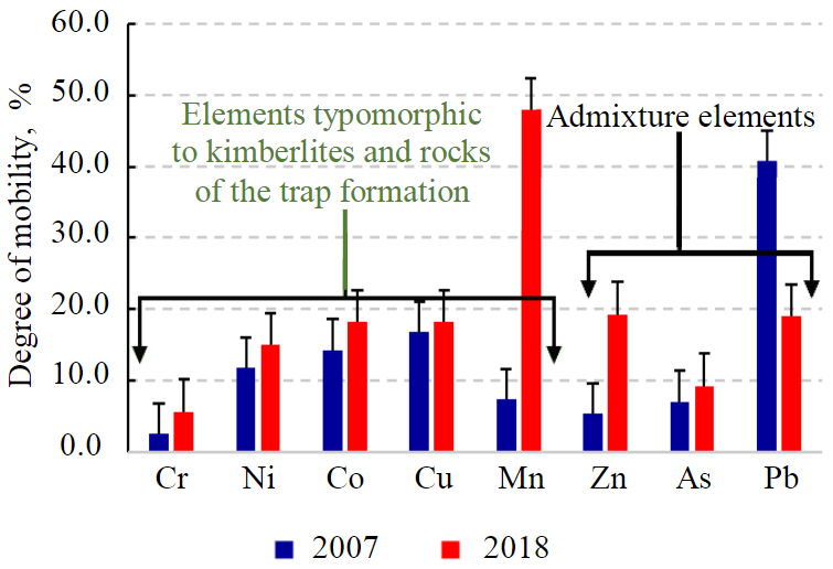
Fig.3. Degree of mobility of trace elements in the surface layer of soils of the NMPD industrial site by years of investigations
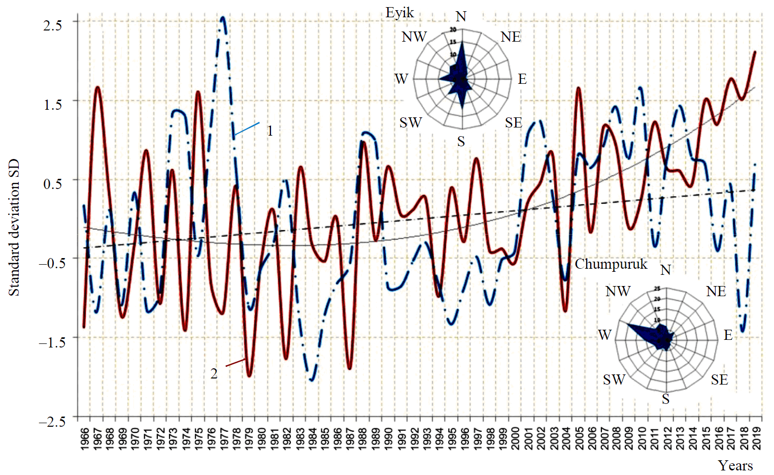
Fig.4. Graph of the variation of average annual air temperatures and the amount of annual precipitation according to the Chumpuruk weather station 1 – annual precipitation; 2 – average annual temperatures
The degree of dusting of dumps increases with their height; their dusting is possible at a wind speed of more than 5 m/s [49]. According to the Chumpuruk weather station, in 2005-2019, in dry weather, wind with a speed of 5 m/s or more was observed in 15-145 cases per year (57 on average). According to the Eyik weather station, there are an average of 370 cases per year. Strengthening of the wind is associated with the intensification of cyclonic activity, for this area more often of the western and north-western direction.
In the spring, there are separate landfalls of southern cyclones in Yakutia. In addition to circulation factors, the wind regime is influenced by the location of the weather station and, above all, by the topography. For the Chumpuruk meteorological station, the main wind direction coincides with the direction of the valley; the data of the Eyik meteorological station are significantly affected by its location on the northern coast of a large cognominal lake.
It turns out that in order to characterize the Nakyn field area, on the basis of geographical environmental analysis of climatic factors, by the number of strong winds, one can be guided by the data from the Chumpuruk weather station, and by the wind direction, by the data from the Eyik weather station. In this case, the main large-scale source of material for dust scattering and the formation of surface technogenic contamination of the soil cover are waste rock dumps. In short time periods, a significant amount of pollutant may fall out at a distance from the dumps. In a long time period, the entire area adjacent to the industrial site should be subjected to air contamination.
The studies carried out made it possible to determine the regularities of the intra-profile and spatial distribution of trace elements in the soils of the Nakyn kimberlite field. The formation of technogenic anomalies in the soil cover, spatially linked to technogenically transformed landscapes, ground and underground technogenic storages, can be traced at the industrial sites of other mining and beneficiation plants in Yakutia [50, 51]. The soil cover of the Mirninsky, Daldynsky, Alakit-Markhinsky and Nakyn kimberlite fields, within which mining and beneficiation plants operate, differs in structure and some basic physical and chemical properties of soils, but is characterized by similar manifestations of natural geochemical anomalies in the soil cover. Technogenically transformed landscapes at the industrial sites of mining and beneficiation plants form contamination halos, as a rule, of a surface nature. The nature of contamination and the spatial aspect of technogenic anomalies is individual for each site under consideration. Therefore, the revealed patterns exist under the conditions of a real technogenic impact, where there is a high probability of the emergence of new additional factors that, superimposed on the existing ones, can adjust the microelement composition of soils and increase the halos of secondary technogenic contamination.
Over the eleven-year period of observation of the soil cover state in the Khannya-Nakyn interfluve, the geochemical environmental situation worsened with an increase in the area of soil contamination and the contrast of its manifestation. Due to the high cyclonic activity, the main source of the technogenic anomalies in the surface horizons of soils in the industrial site of the NMPD are waste rock dumps or technogenic surface storages. The high sorption capacity of the upper organogenic horizons of cryozems contributes to the intensive accumulation of trace elements, including heavy metals. Thus, the upper organogenic horizons of cryozems perform a protective function in relation to the contamination of the entire soil profile. This ability of trace elements coming from outside as a result of air transport to be firmly settled by soil organic matter is a factor that can provide a low risk of multielement contamination for the entire ecosystem, provided that the soil profile integrity is maintained.
Conclusion
The zonal soil types of the Nakyn kimberlite field are cryozems with varying degrees of manifestation of gleization and cryoturbation. A distinctive feature of the intra-profile distribution of mobile forms of trace elements in the studied types of cryozems is the presence of two maxima: biogenic accumulation in the upper organogenic horizon followed by a decrease down the profile and a second peak in the suprapermafrost horizon. Biogenic accumulation in the AO and Acr horizons is characteristic of the mobile forms of Ni, Mn, and Cd; suprapermafrost accumulation in the CR horizon is characteristic of the mobile forms of Cr, Ni, Co, Mn, and Cu.
In grounds and soils subjected to technogenic impact, there is a redistribution in the composition of mobile forms of trace elements. Elements typomorphic to kimberlites take the first place. In general, the percentage of the content of mobile forms of almost all determined trace elements increases. The grounds are distinguished by anomalously high concentrations of mobile forms of Mn, Zn, Ni, Cr, Co, As with concentration indices varying over a very wide range. The cryozems of the impact zone in the preserved forest areas are characterized by surface accumulation of mobile forms of Mn, Ni, Zn, and Co.
In general, the soil cover of the NMPD industrial site at the time of the study is characterized by a multielement composition of natural and technogenic anomalies. Based on the estimation of the total index of soil cover contamination Zc a spatial increase in highly and very highly contaminated areas was revealed. The main Zc-forming elements that determine the high level of soil contamination are Mn, Zn, and Ni.
The natural anomaly in soils manifests itself in the regular distribution of mobile forms of trace elements in the soil stratum with accumulation in the upper organogenic and suprapermafrost horizons, the suprapermafrost accumulation is higher than the biogenic one, which is a consequence of the natural geological and geochemical conditions for the formation of kimberlite fields. In the zones of direct impact of infrastructure facilities of the mining and beneficiation plant, a large amount of fine clay fraction is concentrated on the surface, characterized by an increased content of Cr-Ni-Co and Cu-Mn associations, which is manifested in high concentrations of mobile forms of these elements in the surface horizons of soils.
The pattern of surface technogenic anomalies in soils corresponds to the direction of the prevailing western and north-western winds.
When the soil cover, the integrity of the soil profile are disturbed, and the mineral part of the soil profile is exposed, the geochemical conditions change, as a result of which most of the trace elements pass into a mobile state, water-soluble and acid-soluble forms, etc., i.e. become more accessible to plants, soluble in water, which creates tension in the overall environmental situation in the area affected by the mining and processing plant.
The results obtained are especially important for the measures for rehabilitation of the soil cover in the impact zone of mining and beneficiation plants, for geoenvironmental monitoring and assessing the landscape resistance to chemical contamination. These data will serve as the basis for predicting soil contamination with trace elements, including heavy metals.
References
- Žibret G., Gosar M., Miler M., Alijagić J. Impacts of mining and smelting activities on environment and landscape degradation – Slovenian case studies. Land Degradation & Development. 2018. Vol. 29. Iss. 12, p. 4457-4470. DOI: 10.1002/ldr.3198
- Dhar A., Miller V.S., Wilkinson S.R., Naeth M.A. Substrate and Topsoil Impact on Soil Water and Soil Temperature in Arctic Diamond Mine Reclamation. Soil Systems. 2022. Vol. 6. Iss. 1. N 12. DOI: 10.3390/soilsystems6010012
- Yurkevich N.V., Eltsov I.N., Gureev V.N. et al. Technogenic impact on the environment in the Russian Arctic on the example of the Norilsk industrial region. Bulletin of the Tomsk Polytechnic University Geo Assets Engineering. 2021. Vol. 332. N 12, p. 230-249 (in Russian). DOI: 10.18799/24131830/2021/12/3207
- Bloodworth A.J., Scott P.W., McEvoy F.M. Digging the backyard: Mining and quarrying in the UK and their impact on future land use. Land Use Policy. 2009. Vol. 26, p. S317-S325. DOI: 10.1016/j.landusepol.2009.08.022
- Newman J.E., Levasseur P.A., Beckett P., Watmough S.A. The impact of severe pollution from smelter emissions on carbon and metal accumulation in peatlands in Ontario, Canada. Environmental Pollution. 2023. Vol. 320. N 121102. DOI: 10.1016/j.envpol.2023.121102
- Benidire L., Benidire L., Boularbah A. Impacts of mining activities on soil properties: case studies from Morocco mine sites. Soil Science Annual. 2020. Vol. 74. Iss. 4, p. 395-407. DOI: 10.37501/soilsa/133011
- Xiu-Wu Zhang, Lin-Sheng Yang, Yong-Hua Li et al. Estimation of lead and zinc emissions from mineral exploitation based on characteristics of lead/zinc deposits in China. Transactions of Nonferrous Metals Society of China. 2011. Vol. 21. Iss. 11, p. 2513-2519. DOI: 10.1016/S1003-6326(11)61044-3
- Wilkin R.T., Lee T.R., Beak D.G. et al. Groundwater co-contaminant behavior of arsenic and selenium at a lead and zinc smelting facility. Applied Geochemistry. 2018. Vol. 89, p. 255-264. DOI: 10.1016/j.apgeochem.2017.12.011
- Belosheikina A.V., Talovskaya A.V., Yazikov E.G. Ecological and geochemical assessment of the state of the soil cover on the territory of the Sorsky Mining and Processing Plant (Republic of Khakassia). Bulletin of the Tomsk Polytechnic University Geo Assets Engineering. 2020. Vol. 331. N 1, p. 44-53 (in Russian). DOI: 10.18799/24131830/2020/1/2446
- Demkova L., Tomas. J., Bobulska L. Assessment of soil heavy metal pollution in a former mining area – before and after the end of mining activities. Soil and Water Research. 2017. Vol. 12. Iss. 4, p. 229-236. DOI: 10.17221/107/2016-SWR
- Slavikovsky O.V., Slavikovskaya Yu.O., Valiev N.G. Subsoil Capacity of Geo-Technologies as a Fundamental Factor of the Effect of Mining Complex to the Environment. Izvestiya vuzov. Gornyi zhurnal. 2011. N 2, p. 70-75 (in Russian).
- Zenkov I.V. Review of foreign researches in the field of mining ecology. Gornyi zhurnal. 2016. N 10, p. 96-99 (in Russian). DOI: 10.17580/gzh.2016.10.20
- Abiola O., Adegbola O., Hu R., Atta R. Assessment of trace metals contamination in stream sediments and soils in Abuja leather mining, southwestern Nigeria. Acta Geochimica. 2018. Vol. 37. Iss. 4, p. 592-613. DOI: 10.1007/s11631-017-0256-1
- Xufeng Fei, Zhaohan Lou, George Christakos et al. The association between heavy metal soil pollution and stomach cancer: a case study in Hangzhou City, China. Environmental Geochemistry and Health. 2018. Vol. 40. Iss. 6, p. 2481-2490. DOI: 10.1007/s10653-018-0113-0
- Sarapulova G.I. Environmental Geochemical Assessment of Technogenic Soils. Journal of Mining Institute. 2018. Vol. 234, p. 658-662. DOI: 10.31897/PMI.2018.6.658
- Ushakova E.S., Karavaeva T.I., Belkin P.A. The Ecological State of Soils in Industrial Territories (on the Example of Berezniki, Perm Territory): Comparison of Domestic and Foreign Assessment Methods. Bulletin of the Tomsk Polytechnic University Geo Assets Engineering. 2020. Vol. 331. N 10, p. 58-70 (in Russian). DOI: 10.18799/24131830/2020/10/2850
- Hu Zhenqi, Wang Peijun, Li Jing. Ecological Restoration of Abandoned Mine Land in China. Journal of Resources and Ecology. 2012. Vol. 3. Iss. 4, p. 289-296. DOI: 10.5814/j.issn.1674-764x.2012.04.001
- Yanin E.P. Chemical composition and geochemical environmental of urban soils. Analytical review. Problemy okruzhayushchei sredy i prirodnykh resursov. 2020. N 2, p. 40-73 (in Russian). DOI: 10.36535/0235-5019-2020-02-3
- Basova I.A., Ivatanova N.P., Kopylov A.B. Assessment of the ecological state of soils in regions with a developed mining industry. News of the Tula State University. Natural Sciences. 2012. N 1-2, p. 14-16 (in Russian).
- Naeth M.A., Wilkinson S.R. Establishment of Restoration Trajectories for Upland Tundra Communities on Diamond Mine Wastes in the Canadian Arctic. Restoration Ecology. 2014. Vol. 22. Iss. 4, p. 534-543. DOI: 10.1111/rec.12106
- Sena K., Barton C., Hall S. et al. Influence of spoil type on afforestation success and natural vegetative recolonization on a surface coal mine in Appalachia, United States. Restoration Ecology. 2015. Vol. 23. Iss. 2, p. 131-138. DOI: 10.1111/rec.12164
- Shafigullina G.T., Udachin V.N., Aminov P.G., Filippova K.A. Geochemical Characteristics of Technogenic Soils in the Mining Landscapes of the South Urals. Vestnik Akademii nauk Respubliki Bashkortostan. 2015. Vol. 20. N 4 (80), p. 93-101 (in Russian).
- Myga-Piątek U. Landscape management on post -exploitation land using the example of the Silesian region, Poland. Environmental and Socio-economic Studies. 2014. Vol. 2. Iss. 1, p. 1-8. DOI: 10.1515/environ-2015-0026
- Oelofse S.H.H. Mine water pollution – acid mine decant, effluent and treatment: a consideration of key emerging issues that may impact the State of the Environment. Mining: Environment and Health Concerns, 2008, p. 83-91.
- Zabergja-Ferati F., Mustafa M.K., Abazaj F. Heavy Metal Contamination and Accumulation in Soil and Plant from Mining Area of Mitrovica, Kosovo. Bulletin of Environmental Contamination and Toxicology. 2021. Vol. 107. Iss. 3, p. 537-543. DOI: 10.1007/s00128-021-03223-6
- Fei Zang, Shengli Wang, Zhongren Nan et al. Accumulation, spatio-temporal distribution, and risk assessment of heavy metals in the soil-corn system around a polymetallic mining area from the Loess Plateau, northwest China. Geoderma. 2017. Vol. 305, p. 188-196. DOI: 10.1016/j.geoderma.2017.06.008
- Xiao Qing, Zong Yutong, Lu Shenggao. Assessment of heavy metal pollution and human health risk in urban soils of steel industrial city (Anshan), Liaoning, Northeast China. Ecotoxicology and Environmental Safety. 2015. Vol. 120, p. 377-385. DOI: 10.1016/j.ecoenv.2015.06.019
- Nevedrov N.P. Profile distribution and migration of heavy metals in the soils of the Kursk agglomeration (model experiments). South of Russia: ecology, development. 2020. Vol. 15. N 1, p. 60-68 (in Russian). DOI: 10.18470/1992‐1098‐2020‐1‐60‐68
- Yuebing Sun, Qixing Zhou, Xiaokui Xie, Rui Liu. Spatial, sources and risk assessment of heavy metal contamination of urban soils in typical regions of Shenyang, China. Journal of Hazardous Materials. 2010. Vol. 174. Iss. 1-3, p. 455-462. DOI: 10.1016/j.jhazmat.2009.09.074
- Long Zhao, Yafei Xu, Hong Hou et al. Source identification and health risk assessment of metals in urban soils around the Tanggu chemical industrial district, Tianjin, China. Science of The Total Environment. 2014. Vol. 468-469, p. 654-662. DOI: 10.1016/j.scitotenv.2013.08.094
- Aklambetova K.M. Environmental consequences of mineral deposit development and their impact on the natural environment. Aktualnye problemy zdorovya cheloveka i formirovanie sredy obitaniya: Materialy mezhdunarodnoi nauchno-prakticheskoi konferentsii, 22 maya 2002, Karaganda, Russia. Karaganda: Izd-vo KarGU, 2002, p. 23-27 (in Russian).
- Fujun Niu, Zeyong Gao, Zhanju Lin et al. Vegetation influence on the soil hydrological regime in permafrost regions of the Qinghai – Tibet Plateau, China. Geoderma. 2019. Vol. 354. N 113892. DOI: 10.1016/j.geoderma.2019.113892
- Prach K., Karešová P., Jírová A. et al. Do not neglect surroundings in restoration of disturbed sites. Restoration Ecology. 2015. Vol. 23. Iss. 3, p. 310-314. DOI: 10.1111/rec.12189
- Mikhalchuk N.V. Mobile forms of heavy metals and trace elements in the soils of the carbonate series of the south-west of Belarus. Proceedings of the National Academy of Sciences of Belarus. Chemical Sciences Series. 2017. N 3, p. 90-97 (in Russian).
- Gololobova A.G. Heavy Metal Mobility and Trace Elements in Permafrost Soils Under Anthropization. International Research Journal. 2020. N 12 (102). Part 2, p. 49-54 (in Russian). DOI: 10.23670/IRJ.2020.102.12.043
- Targulyan V.O., Goryachkin S.V., Karavaeva N.A. et al. Soil memory: soil as a memory of biosphere-geosphere-anthropogenic interactions. Moscow: Izd-vo LKI, 2008, p. 692 (in Russian).
- Rusanova G., Shakhtarova O. Structural Organization and Matter Differentiation of Bolshezemelskaya Tundra South-East Automorphic Soils. Tomsk State University Journal of Biology. 2012. N 3 (19), p. 18-32 (in Russian).
- Gorev N.I., Gerasimchuk A.V., Protsenko E.V., Tolstov A.V. Tectonic aspects of the structure of the Vilyuisko-Markhinskaya zone, their use in predicting kimberlite fields. Nauka i obrazovanie. 2011. N 3, p. 5-10 (in Russian).
- Ladonin D.V. Heavy metal compounds in soils, problems and methods of study. Pochvovedenie. 2002. Vol. 35. N 6, p. 605-614 (in Russian).
- Syso A.I. Patterns of the distribution of chemical elements in soil-forming rocks and soils of Western Siberia. Novosibirsk: Izd-vo Sibirskogo otdeleniya RAN, 2007, p. 227 (in Russian).
- Osinseva E.V., Agisheva S.T., Gorbunova E.M. et al. Reference Materials System of Scientific Methodical Centre of State Service of Reference Materials for Composition and Properties of Substances and Materials Ural Research Institute for Metrology. Standartnye obraztsy – Reference materials. 2015. N 2, p. 31-55 (in Russian).
- Saet Yu.E., Revich B.A., Yanin E.P. Environmental geochemistry. Moscow: Nedra, 1990, p. 335 (in Russian).
- Legostaeva Ya.B., Ksenofontova M.I., Dyagileva A.G. Geochemical environmental monitoring of the soil cover in the impact zone of the Nyurba Mining and Processing Division. Gornyi zhurnal. 2014. N 4, p. 117-121 (in Russian).
- Gololobova A.G., Legostaeva Ya.B. Heavy metals in cryozems of Western Yakutia. International Multidisciplinary Scientific GeoConference Surveying Geology and Mining Ecology Management, SGEM. 2019. Vol. 19. N 3.2, p. 239-246. DOI: 10.5593/sgem2019/3.2/S13.032
- Field manual of Russian soils. Moscow: Pochvennyi institut im. V.V.Dokuchaeva, 2008, p. 182 (in Russian).
- Dyagileva A.G. Resistance to chemical contamination of cryozems in Western Yakutia. Avtoref. dis. ... kand. biol. nauk. Ulan-Ude: Institut obshchei i eksperimentalnoi biologii Sibirskogo otdeleniya RAN, 2015, p. 23 (in Russian).
- Yagnyshev B.S., Yagnysheva T.A., Zinchuk M.N., Legostaeva Ya.B. Environment of Western Yakutia (geochemistry of geosystems: state and problems). Yakutsk: Izd-vo Yakutskogo nauchnogo tsentra Sibirskogo otdeleniya RAN, 2005, p. 432 (in Russian).
- Legostaeva Ya.B., Gololobova A.G. Long-term geochemical monitoring of the soil cover in the impact zone of diamond mining enterprises: a case study in the Nakyn kimberlite field, Russia. Environmental Monitoring and Assessment. 2021. Vol. 193. Iss. 6. N 337. DOI: 10.1007/s10661-021-09087-x
- Amosov P.V., Baklanov A.A., Masloboev V.A. The results of the assessment of air pollution during dusting of the tailings (based on three-dimensional modeling). Minerals and Mining Engineering. 2017. N 6, p. 87-94 (in Russian).
- Khovanskaya M.A., Kosinova I.I. Influence of mining and processing activity on soil of Ajhalskiy area (Sakha-Yakutia). Proceedings of Voronezh State University. Series: Geology. 2010. N 1, p. 282-285 (in Russian).
- Legostaeva Ya.B., Gololobova A.G. Features of distribution of microelements in soils of background and impact zones at diamond mining sites in the North-West of the Siberian Platform. Bulletin of the Tomsk Polytechnic University Geo Assets Engineering. 2021. Vol. 332. N 9, p. 142-153 (in Russian). DOI: 10.18799/24131830/2021/9/3364