Results of Comprehensive Geophysical Studies on the Search for Crypts on the Territory of Suburban Necropolis of Tauric Chersonese in the Karantinnaya Balka

Abstract
The article presents the results of comprehensive studies carried out by the research team of Saint Petersburg Mining University in cooperation with the specialists from the State Museum-Preserve "Tauric Chersonese" in 2019. The purpose of the work was to discover and map antique and medieval crypts (ancient burial structures) on the territory of suburban necropolis of Tauric Chersonese in the Karantinnaya balka. The complex of geophysical methods included continuous ground penetrating radar sounding at two center frequencies of 350 and 500 MHz and contactless electrical tomography. To minimize spatial errors in the process of studies, topographic and geodetic works were carried out. For the first time wave electromagnetic effects were identified, which indicated the positions of hidden underground crypts. Geological factors were established that are favorable for cutting crypts in the layered thickness of Sarmatian limestones. The obtained results allowed to justify the feasibility of continuing geophysical works at the necropolis in order to study interior space of the discovered crypts and to determine the boundaries of archaeological heritage.
None
Introduction. The territory of the suburban church necropolis in the Karantinnaya balka of the State Museum-Preserve “Tauric Chersonese” is an object of increased interest for specialists and scientists in a number of areas: archeology, art history, geophysics and geology [1, 6, 11, 20]. The reason behind the increased attention to this place is associated with its extremely rich history. It represents a unique chronicle of life and daily routines of people in the past. Up to this day, a large number of ancient sites are hidden under the surface and have not been explored yet [7, 19]. Conducting traditional archaeological excavations is associated with great financial and time expenditures, and also inevitably entails physical demolition of the majority of historical data, which then exist only in the form of scientific reports. Concurrently, there is a need to resolve complex issues regarding further conservation of the facility.
Recently, methods of archaeological geophysics have been used to obtain information on archaeological sites with minimal invasive influence. At the level of methodological developments, recommended by the Ministry of Culture of the Russian Federation in the direction of ensuring preservation of archaeological heritage, geophysical methods are recognized as one of the bases for determining territory boundaries of archaeological heritage objects and subsequent museification of the studied territory. Thus, the introduction of geophysical methods to the generally accepted practice of archaeological field work makes a tangible contribution to territory determination and substantiation of such hard-to-find sites as subsoil burial grounds and necropolises.
The main purpose of the work is to search for hidden under the daylight surface antique and medieval crypts, carved out in the limestone massif on the territory of Karantinnaya balka necropolis (Fig. 1). The research objective is to carry out comprehensive geophysical studies using ground penetrating radar and electric profiling methods to detect crypt locations and to study geological structure of the work area. The choice of these particular research methods is based on previous experimental and methodological work in Chersonese [6, 7], as well as on the results of Russian and foreign geophysical studies of cultural and historical sites [2, 3, 21, 24-26].
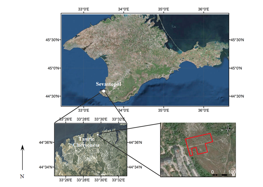
Research object. The necropolis is located in the lower part of the Karaninnaya balka mouth, which cuts through the outcrops of Sarmatian limestones [5, 9]. It occupies the thalweg of the bay and a part of its right and left slopes, formed by the rocky spurs of the Maiden Mountain and the right side of the bay. Up to this day, a significant area of the necropolis still remains unexplored [8, 10, 14, 16].
The work area is located on the northwestern slope of the Karantinnaya balka. It is represented by four quadrangles linked to each other in the same coordinate system.
Geomorphology of the slope within the study area is represented by two terraces. In the north the site is bounded by coastal ledges of the Karantinnaya balka. Within the site there are obstacles to geophysical surveys, which include pits, piles of earth and debris, as well as bushes and trees. In these places works were not performed for technical reasons.
An excavated part of the necropolis adjoins the site from the northwest. Within the limits of the investigated area, there is a crypt discovered earlier by excavations, indicating that the selected area is a continuation of the necropolis. The presence of crypts and geomorphological prerequisites, according to which the crypts are located along the terrace ledges, allows to regard the site selected for geophysical research as promising for the discovery of hidden burial structures of the necropolis [12, 18-20, 27].
The overwhelming majority of burial sites are represented by three types of structures: crypts, undercut graves and pit graves. Almost all of them are carved in the rock. Crypts are the dominant type of burial structures. Typical crypts have an entrance pit - dromos, at the end of which there is an entrance to the burial chamber, blocked with a slab. Unique fresco paintings were found on the walls of several crypts [13, 15] (Fig.2).
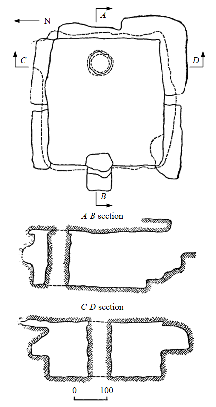
The crypts have the form of cavities close to a rectangular shape, cut out in the rocky limestone massif. The depth of crypt arches varies from 1 to 3 m, and the height does not exceed 2 m. The area of burial structures ranges from 6 to 15 m2. Some crypts have two chambers. The walls of the crypts have niches carved into them. Dromos is carved in the rock and usually has a rectangular shape with approximate dimensions of 1 × 2 m [4, 17, 18, 20].
Research methodology. The method of geophysical research provided localization of hidden crypts and exploration of geological structure of the rock mass in the selected area of the Karantinnaya balka necropolis. The complex of studies included the methods of ground penetrating radar and electrical tomography. Ground penetrating radar studies were used to determine the location and depth of crypt arches, whereas electrotomographic data were used to study geological structure of the territory. Along with that, conducting a topographic and geodetic survey provided a detailed topographic map of the area with geodetic binding of geophysical profiles.
Geophysical observations within each of the four quadrangles of the site were carried out using the system of parallel profiles, the distance between which, depending on the type of work, was 1-2 m.
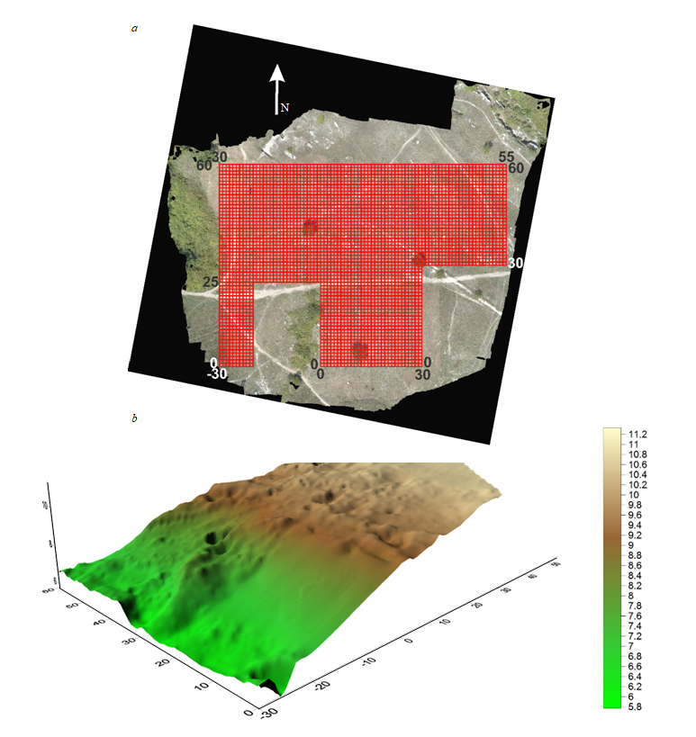
Geodetic survey. To mark the quadrangles of geophysical survey, the method of setting out design points with electronic total station SET530RK3 by means of angular intersection was used. To produce maps and terrain plans, photogrammetric works were performed using a set of images made with a DJI Phantom 4 Pro quadcopter. Nowadays the use of unmanned aerial vehicles for solving problems of archaeology and engineering geology is especially popular [22, 28, 31, 32]. Topographic binding was carried out using geodetic satellite receivers Sokkia GRX 2 (in Real Time Kinematic mode). As a result of measurements, an orthophotomap was obtained, on the basis of which the profiles, necessary for the production of geophysical works, were marked with an indication of observation point heights (Fig.3).
Ground penetrating radar works. Georadar survey was carried out using the georadar “Zond-12 E Advanced” (Radar System Inc.) [29]. and shielded antenna units with center frequencies of the probing pulses 300 and 500 MHz. Survey execution at two center frequencies is explained by the fact that in some areas of the surveyed territory there are soils characterized by a high coefficient of electromagnetic wave absorption. The sounding depth under unfavorable conditions at the frequency of 500 MHz did not exceed 2 m. The 300 MHz antenna provided an exploration depth of 5 m in these areas. Data from the survey at 500 MHz frequency allowed to explore in more detail the upper part of the geological section to the depth of 3 m, while the survey at 300 MHz frequency opened up deeper parts of the section to the depth of 5.5 m.
Ground penetrating radar (GPR) sounding was carried out using a network of parallel profiles at a distance of 1 m. The sounding step was 5 cm. The technique of surveying and processing of GPR sounding data allowed to obtain continuous GPR sections.
Electrical tomography survey. The presence of rocky outcrops and small thickness of the dry topsoil layer in some areas of the surveyed territory led to the use of non-contact methods of electrical exploration [23, 30]. To carry out field work, the technology of multi-spacing electrical profiling was applied using a non-contact meter of apparent resistivity “BIKS” (JSC “Special Design Bureau for Seismic Instrumentation”, Saratov). The station interval along the profiles was 1 m, the distance between the profiles was 2 m. Observations were carried out with the installation of dipole axial profiling with dipoles of 1.25, 2.5 and 5 m and spacing sequentially changing from 3.75 to 25 m.
Procedures of processing (Geotomo Software, Malaysia) and interpretation of electrotomographic research data provided 2D geoelectric sections, characterizing geological structure of the necropolis up to the depth of 7 m.
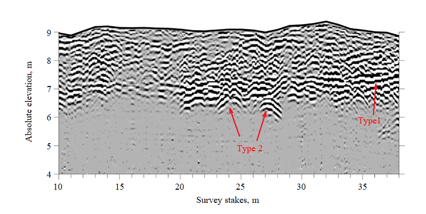
Results of comprehensive geophysical studies. The results of comprehensive geophysical studies are presented in the form of GPR and geoelectric sections, characterizing geological structure and location of archaeological objects (crypts).
On GPR sections two types of main wave effects of the electromagnetic field are clearly manifested (Fig.4). Type 1 is distinguished as a multiphase extended correlation line, characterizing the position of the geological boundary, separating limestone layers of different composition and hardness. Type 2 is manifested with diffraction-reverberation effects of the wave field of varying intensity. The vertices of inverse hyperbolas reflect the position of the cavity arch, which in case of the necropolis is usually a crypt.
Thus, GPR sections characterize geological structure and location of archaeological objects within the necropolis. These data should be regarded as the basic information necessary for the construction of forecast maps and a volumetric model, characterizing the positions of hidden crypts on the surveyed territory of the necropolis.
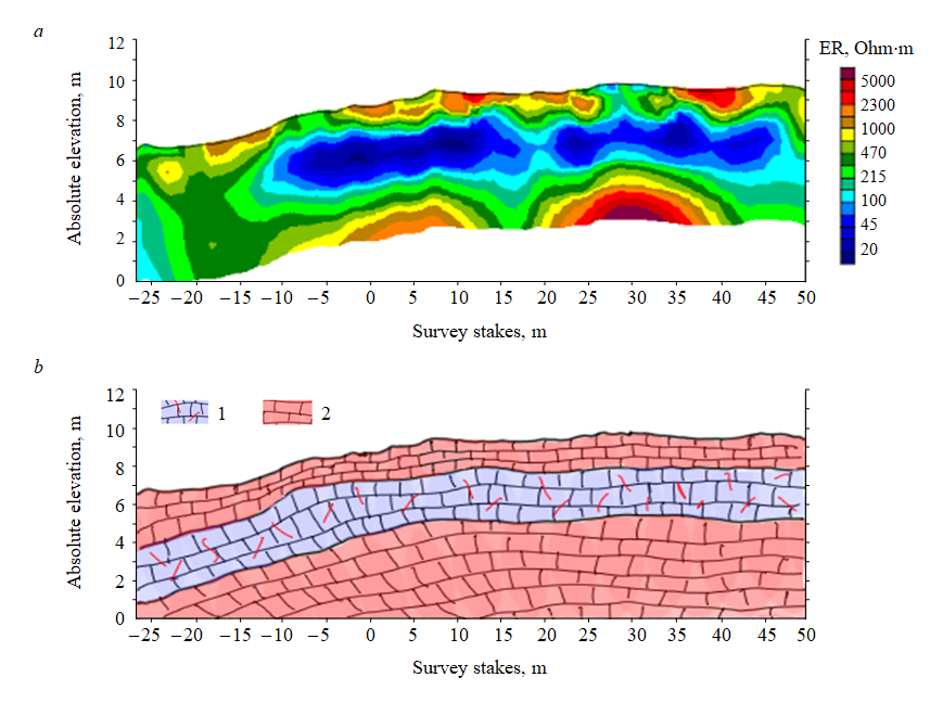
The information obtained by means of electrotomographic studies is presented in the form of geoelectric sections (Fig.5), characterizing specific features of geological structure of the necropolis section. Three layers are distinguished on the geoelectric section. The upper layer is represented by hard limestones; it is characterized by high values of electrical resistivity and has a thickness of about 1 m. It is assumed that it protects the crypt from collapsing. It should be noted that in this layer there are traces that indicate distortions, associated with construction work – in particular, with the cutting of crypt dromoses. The middle layer has relatively low resistivity, which indirectly indicates its reduced hardness. It is in this layer that the largest number of necropolis crypts are located, since it was best suited for cutting crypts due to its relatively low strength properties. The presence of this layer is a prerequisite for finding hidden crypts. The third layer is composed of high-resistivity rocks and represents a solid and stable foundation for the crypts.
Thus, geological information is an important component for understanding the general picture of crypt distribution specifics on the territory of the necropolis.
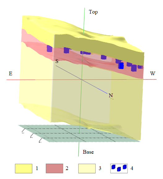
Based on the obtained GPR sections with the involvement of electric tomography data, a preliminary forecast diagram (Fig. 6) and a 3D model of hidden crypt locations (Fig.7) were constructed. The article provides only a fragment of this diagram and the model, publication of the entire material jeopardizes further preservation of the crypts discovered by non-contact methods, since the so-called “grave robbers” are actively operating in the region. The scale is deliberately not specified and distorted.
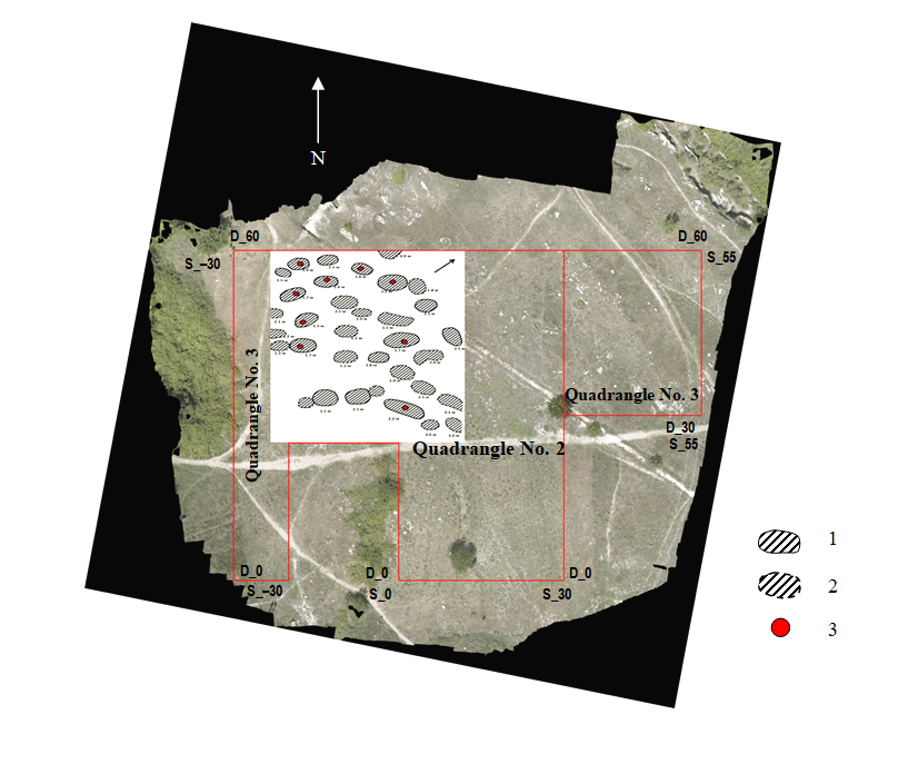
The diagram shows the contours of GPR anomalies that characterize location and size of the crypts. The contours shown by the dashed line correspond to diffraction-reverberation disturbances of the wave electromagnetic field, which reliably correlate across several profiles. The dashed line corresponds to less intense anomalies that are not clearly visible on the adjacent profiles.
In the places where anomalies adjoin, dashed line contours may indicate the location of crypt dromoses, contoured with a solid line. The depths shown on the map near the anomalous zones characterize the position of crypt arches in the section. The error of depth estimation due to the influence of unaccounted data on electrophysical properties of soil and rocks can amount to 10-15 %. The diagram shows recommended positions for confirmatory drilling of GPR anomaly sources.
The boundaries and characteristics of the archaeological objects shown on the diagram are inferred, since they are not confirmed by drilling and excavations. The position of these boundaries is to be specified upon receipt of additional data. It is assumed that drilling will be the next logical and possibly the final stage of the entire complex of works. Methodological features of such drilling at this site require careful consideration in terms of legislative registration of the works, solution to the problem of maximally ensuring physical safety of hypothetical archaeological objects and the specifics of results presentation for their further use by all interested parties: scientists, museum staff, employees of the agencies for cultural heritage protection.
Conclusions. The results of comprehensive geophysical studies reflect the distribution of anomalous areas on the studied territory, which can be interpreted as the sought-after crypts.
Based on geophysical data obtained in the course of work, the most promising places for single-point drilling and confirmation of the detected anomalies were highlighted. Before sinking each borehole it is necessary to perform additional detailed geophysical survey.
The obtained forecast diagram is the basis for further geophysical research in the nearby territories in order to determine the boundaries of archaeological heritage of the necropolis in the Karantinnaya balka.
References
- Zhuravlev D.V., Kostromichev D.A. On One Rich Burial of the Chersonese Necropolis (Urn 53 from R.Kh.Leper excavations in 1912). Readings “Culture and Art of the Ancient Black Sea Region”, 19-20 November 2015, Saint Petersburg, Russia. St. Petersburg: Institute for the History of Material Culture, Russian Academy of Sciences, 2015 (in Russian).
- Zhurbin I.V. Geophysical examinations of planning and fortification constructions in the Rozhdestvenskoe settlement. Pro-ceedings of the Kama archaeological and ethnographic expedition. 2012. N 8, p. 306-312 (in Russian).
- Zhurbin I.V. Application of geophysical methods to the estimation of structure and borders of fortified settlements. Proceed-ings of the Kama archaeological and ethnographic expedition. 2014. N 9, p. 50-56 (in Russian).
- Zavadskaya I.A. On the interpretation of human figures in the painting of the early Christian crypts of Chersonesos. XIX Bosporan readings. Cimmerian Bosporus and the World of Barbarians in Antiquity and the Middle Ages. Traditions and innovations, 18-22 May 2020, Simferopol-Kerch, Russia. Demetra, 2020, p. 110-113 (in Russian).
- Zubar V.M. The Necropolis of Tauric Chersonese in 1st-4th Centuries A.D. Kiev: Naukova dumka, 1982, p.146 (in Russian).
- Glazunov V.V., Modin I.N., Topilina T.V. et al. Innovative Archaeological and Geophysical Research of the Chersonesus Necropolis Nearthe Karantinnaia Bay. XIX Bosporan readings. Cimmerian Bosporus and the World of Barbarians in Antiquity and the Middle Ages. Traditions and innovations, 21-25 May 2018, Simferopol-Kerch, Russiaa. Demetra, 2018, p. 115-122 (in Russian).
- Glazunov V.V., Modin I.N., Topilina T.V. et al. Integrated Geophysical Studies for the Establishment of the 3D Model of the Chersonesus Necropolis. Engineering and Mining Geophysics 2019, 22-26 April 2019, Gelendzhik, Russia. EAGE, 2019, p. 1-7. DOI: 10.3997/2214-4609.201901709 (in Russian).
- Kostromichev D.A. Three Burials of Roman Soldiers from the Necropolis of Chersonesos. Materials in Archaeology, History and Ethnography of Tauria. 2005. Vol. XI, p. 94-118 (in Russian).
- Lomakin I.E., Ivanov V.E., Topolyuk A.S., Efremtseva L.L. New Data on the Geological Structure of the Coastline of South-Western Crimea. GPIMO. 2010. N 4, p. 30-39 (in Russian).
- Rogov E.Ya. A Centenary of Discovery of an Under-wall Crypt No. 1012 in Chersonese. Stratum plus. Archaeology and Cultural Anthropology. 2000. N 3, p. 88-97 (in Russian).
- Samoilenko V.G. Conservation and Restoration Works in 1900 in Vaults N 1013 and 1014 in the South-Eastern District of Chersonesos. Materials in Archaeology, History and Ethnography of Tauria. 2013. N 18, p. 3-13 (in Russian).
- Silagadze N. Towards some monuments of Tauric Chersonesus and medieval Georgian architecture. Proceedings in Ar-chaeology and History of Ancient and Medieval Black Sea Region. 2017. N 9. p. 342-352 (in Russian).
- Solomonik E.I. Graffiti from the Chora of Chersonese. Kiev: Naukova dumka, 1984, p. 143 (in Russian).
- Solomonik E.I. New Epigraphic Monuments in Chersonese. Kiev: Naukova dumka, 1973, p. 283 (in Russian).
- Stoyanov R.V. Two Slab Burial Structures in Tauric Chersonese. North Black Sea Region in the Antiquity: a collection of research papers. Kiev: National Academy of Sciences of Ukraine, 2002, p. 156-161 (in Russian).
- Stoyanov R.V. The Necropolis of Tauric Chersonese in 5th-1st Centuries B.C. Extended abstract of dissertation for a can-didate degree of historical sciences. Institute for the History of Material Culture. St. Petersburg, 2004, p. 17 (in Russian).
- Stoyanov R.V. New Type of Funeral Wreaths from the Necropolis of Tauric Chersonese. Ancient World and Archaeology. 2002. N 11, p. 187-194 (in Russian).
- Tunkina I.V. Russian Science on the Classical Antiquities of the Russian South (18th – Middle of 19th Century). St. Pe-tersburg: Nauka, 2002, p. 676 (in Russian).
- Turovskii E.Ya. Bosporus and Chersonese: Together and Apart (4th-3rd Centuries B.C.). XIX Bosporan Readings: Interna-tional Scientific Conference. Kerch: V.I.Vernadsky Crimean Federal University, 2018, p. 505-508 (in Russian).
- Chubova A.P., Kolesnikova L.G., Fedorov B.N. Architecture and Art of Tauric Chersonese in 5th Century B.C. – 4th Cen-tury A.D. Мoscow: Izd-vo KMK, 2008, p. 230 (in Russian).
- Shevnin V.A., Bobachev A.A., Ivanova S.V. Results of applying self-potential method and electrical resistivity tomography to study Alexandrovsky settlement (Kaluga region). Journal of Mining Institute. 2015. Vol. 211, p. 35-42.
- Campana S. Drones in Archaeology. State of the art and Future Perspectives. Archaeological Prospection. 2017. Vol. 24. Iss. 4, p. 275-296. DOI: 10.1002/arp.1569
- Kuras O., Beamish D., Meldrum P.I., Ogilvy R.D. Fundamentals of the capacitive resistivity technique. Geophysics. 2006. Vol. 71. Iss. 3, p. 135-152. DOI: 10.1190/1.2194892
- Fischanger F., Catanzariti G., Cominaet C. еt al. Geophysical anomalies detected by electrical resistivity tomography in the area surrounding Tutankhamuns tomb. Journal of Cultural Heritage. 2019. Vol. 36, p. 63-71. DOI: 10.1016/j.culher.2018.07.011
- Salvatore P., Negri S., Quartaet T. et al.Geophysics and Cultural Heritage: a living field of research for Italian Geophysicists. First Break. 2015. Vol. 33. Iss. 8, p. 43-54. DOI: 10.3997/1365-2397.33.8.82013
- Manataki M., Sarris A., Donati J., Cuenca-García C. GPR: Theory and Practice in Archaeological Prospection. Chapter in book: Best Practices of GeoInformatic Technologies for the Mapping of Archaeolands capes. Oxford: Archaeopress Publisher Ltd, 2015, p. 13-25. DOI: 10.13140/RG.2.1.3256.9363
- Kovalevskaja L., Sarnowski T. Investigations of 2013 at site 343 in the rural territory of Chersonesos Taurica, Yukharine ravine (Crimea). Archeologia. 2013. Vol. XI (LII), p. 173-178.
- Kuzin A.A., Valkov V.A., Kazantsev A.I. Satellite-based techniques for monitoring of bridge deformations. International Conference Complex equipment of quality control laboratories 17-19 July 2018, Saint-Petersburg, Russian Federation. Journal of Physics: Conference Series. 2018. Vol. 1118. Iss. 1, p. 012022. DOI: 10.1088/1742-6596/1118/1/012022
- Nyari Z., Kanli A.I. Imaging of Buried 3D Objects by using Electrical Profiling Methods with GPR and 3D Geoelectrical Measurements. Journal Geophysics Engineering. 2007. Vol. 4. Iss. 1, p. 83-93. DOI: 10.1088/1742-2132/4/1/010
- Long M., Donohue S. In situ shear wave velocity from multichannel analysis of surface waves (MASW) tests at eight Norwegian research sites. Canadian Geotechnical Journal. 2007. N 44, p. 533-544. DOI: 10.1139/t07-013
- Mouget A., Lucet G. Photogrammetric Archaeological Survey with UAV. ISPRS Technical Commission V Symposium, 23-25 June 2014, Riva del Garda, Italy. ISPRS, 2014. Vol. II-5, p. 251-258. DOI: 10.5194/isprsannals-II-5-251-2014
- StekT.D. Drones over Mediterranean landscapes. The potential of small UAV's (drones) for site detection and heritage management in archaeological survey projects: A case study from Le Pianelle in the Tappino Valley, Molise (Italy). Journal of Cultural Heritage. 2016. Vol. 22, p. 1066-1071. DOI: 10.1016/j.culher.2016.06.006