Role of shear dislocations in formation of oil and gas potential structures on the northern flank of the Okhotsk oil and gas province
- 1 — Ph.D., Dr.Sci. Head of Department Empress Catherine II Saint Petersburg Mining University ▪ Orcid
- 2 — Ph.D. Senior Lecturer Empress Catherine II Saint Petersburg Mining University ▪ Orcid
- 3 — Ph.D., Dr.Sci. Professor Empress Catherine II Saint Petersburg Mining University ▪ Orcid
Abstract
Specific features of deep structure and tectonics of the Magadan and West Kamchatka shelves in the Sea of Okhotsk and adjacent area of the Kamchatka Peninsula were verified by geological and geophysical modelling. The investigations aimed at studying the localization pattern of hydrocarbon fields on the northern flank of the Okhotsk oil and gas province are based on results of regional and medium-scale geological surveys and prognostic and prospecting studies, geophysical survey data (gravity anomaly field Δg in the Bouguer reduction with an intermediate layer density 2.67 g/cm3, anomalous magnetic field ΔTа, regional seismic lines and the results of their generalizations), and petrophysical well survey materials. Different algorithms for solving the direct and inverse problems as well as pattern recognition with and without training were used in processing and interpretation of potential geophysical fields. The studies showed that the specific features of deep structure and tectonics of the region are determined by the sequence and nature of manifestation of Mesozoic and Cenozoic orogenic processes at the boundaries of the Eurasian and Okhotsk Sea lithospheric paleoplates. The study of regional shear zones developing along the Okhotsk-Chukotka suture zone and the Okhotsk-West Kamchatka Block demonstrated their vital influence on the morphology of sedimentary basins. Thus, the tectonic activity in the Okhotsk-Chukotka shear zone extending subparallel to the Eurasian coast, led to formation of an extensive network of feather dislocations and basins of two types: large longitudinal shear depressions (sedimentary basins that form due to extersion along strike-slip faults) and shear-pull-apart basins oriented at an angle to the axis of the main shear. Mapping of horst uplifts makes it possible to confirm the position of oil and gas formations prioritized for exploration according to the structural criterion.
The work was accomplished under State assignment FSRW-2024-0008 “Study of thermodynamic processes in the Earth with regard to the genesis of hydrocarbons at great depths”.
Introduction
Studies of deep structure and tectonics of the Sea of Okhotsk region accomplished in connection with the prospects of discovering hydrocarbon fields indicated that regional shear dislocations had a significant impact on the formation features of the Okhotsk oil and gas province (OGP) in general and individual depressions within it. Numerous works by the Russian and foreign scientists focus on the studies of the formation mechanism of shear depressions and sedimentation features associated with them [1-3].
Thus, long-term studies by V.P.Utkin and co-authors [4, 5] indicate an active rift destruction of the continental crust in the Asian-Pacific transitional zone in the Late Cretaceous-Cenozoic. In the occurrence area of shears, rift structures formed that controlled sedimentary basins including those of longitudinal and pull-apart type [6]. The Bohai-Amur system of left-lateral shears controls numerous sedimentary basins including relatively small ones, among them basins of the shear-pull-apart type [5].
A great number of large rift basins as well as local linear depressions and pull-apart structures were identified based on the analysis and generalization of the structural and tectonic parameters of oil and gas basins, the formation of which was due to the manifestation of regional shear dislocations. Among them are the coastal and shelf basins in Southern and Central California, Venezuela, Trinidad and Tobago; basins of Southeast Asia and the Bohai Basin in eastern China [7].
Considerable hydrocarbon accumulations were found in shear depressions. Thus, billions of barrels of oil were produced in the San Joaquin and Los Angeles basins in Southern California (USA) [8]. One of the most extensive shear structures controlling the emplacement of sedimentary basins in China is the Tan-Lu fault zone about 80 km wide and 3000 km long with a high potential for oil and gas exploration [3, 9]. It was noted that the emplacement of basins, subsequent tectonic deformations, and sedimentation features there were due to subduction of the Pacific Plate [10]. Analysing seismostratigraphic sections of the Tanyuan graben along one of the branches of the Tan-Lu shear zone, the authors of article [11] concluded that it formed in the pull-apart mode. The Sichuan oil and gas basin (China) which comprises large gas fields also formed under the influence of inclined subduction of the proto-Tethys Ocean. In this case, shear dislocations played a role in the migration of hydrocarbons from the source to the reservoir, stimulation of reservoir, accumulation of gas and high well flow rates [2].
Investigations of the Dead Sea sedimentary basin are indicative, since it is a comprehensively studied longitudinal basin localized along the main shear zone. With a length of 150 km and basement depth more than 8 km, the ratio of dimensions in the longitudinal and orthogonal directions is about 9. The results of laboratory tectonophysical modelling showed that the basement of such a basin is bordered by shear faults, which control its geometry [12].
The Death Valley Basin (Israel) is often cited as a typical example of pull-apart basins. The Valley is bordered by shear faults, the distance between which is about 40 km. The ratio of longitudinal and orthogonal dimensions in the Death Valley Basin is 0.3. Laboratory experiments showed the development of longitudinal steeply dipping shear faults bordering the floor of the basin along its entire length, and normal faults transverse to the main axis [12]. The Hula Basin lying in the central Dead Sea is of pull-apart type. Formation of the basin is associated with left-lateral shear movements of the Sinai and Arabian plates. The structure developed as an asymmetric, pulling-apart (diamond-shaped) basin bounded on the flanks by longitudinal shear faults, and from the south by normal faults facing north [13, 14].
A similar pattern of tectonic destruction is observed within the Gulf of Paria Basin, formed as a result of relative movements of the Caribbean and South American plates along the northern boundary of the latter. The Basin is bounded by the zone of right-lateral shears El Pilar and Arima (in the north) and Warm Springs (in the south). Within the Gulf of Paria Basin, normal fault dislocations of northwestern strike are mapped, determining the step-like pattern of alternating grabens and horsts [15].
A distinctive feature of the Russian Far East versus other oil and gas regions is that the main volumes of confirmed reserves and prospective resources of oil and gas are dispersed across individual sedimentary troughs. According to L.S.Margulis [16], they can be divided into four main types: continental marginal, transitional marginal, deep-water, and back-arc troughs. Sedimentary basins filled with Paleogene-Neogene sedimentary sequences are separated from each other by deep faults and basement uplifts. The role of tectonic processes that formed oil and gas potential structures in the region is noted.
In the works by V.A.Ignatova [17] a comparative characteristic of sedimentary basins of the Far East region and Southeast Asia is given. Specific features of geodynamic environment of their formation made it possible to distinguish three main groups: continental paleorifts, passive continental paleomargins, and active continental margins. Most of sedimentary depressions are assigned to the last group. They mainly formed on the crust of continental or transitional types with extensive development of overthrust dislocations and a marked change in sedimentation conditions, where both continental terrigenous coal-bearing formations and deep-water terrigenous-carbonate strata occur in the section.
Our studies of the northern flank of the Okhotsk OGP indicate the decisive role of regional normal faults in the development of sedimentary basins [18, 19]. Analysis of localization pattern of horsts and grabens showed a possibility of identifying two main types of shear basins characterized above in their development areas: linear longitudinal troughs traced along the axial zone of the main normal fault and pull-apart type depressions oriented at an angle to its axis.
Methods
Studying the localization pattern of potential hydrocarbon structures in the northern Okhotsk province, we used:
- the results of regional and medium-scale geological surveys and specialized prognostic mine-ralogical studies;
- data from geophysical surveys (gravity anomaly field Δg in the Bouguer reduction with an intermediate layer density 2.67 g/cm3, anomalous magnetic field ΔTа, regional seismic lines and results of generalization of detailed seismic surveying);
- data from petrophysical studies of wells;
- scientific publications on research in the Sea of Okhotsk and adjacent structures on the Eurasian continent and Pacific margin [20-22].
To solve the problem, digital models of the gravity field in the Bouguer reduction and the anomalous magnetic field ΔTа of the area covering the northern Sea of Okhotsk region were compiled. Step of the matrix of digital models of potential fields is 500 m.
When processing digital models of potential fields, algorithms were used for decomposing fields into regional and local components, calculating field gradients, recognizing patterns with compilation of a class map based on the COSCAD 3D software package [22]. Along with the above-mentioned transformants, the classification algorithm of D.S.Zelenetsky (ASOD “Air”) was applied. The approaches used to process geophysical field data make it possible to identify areas with a uniform set of features, which provides additional possibilities for interpreting and zoning the study areas [24-26].
Geological interpretation of geophysical anomalies. Based on the qualitative interpretation of a set of geophysical data, a tectonic zoning scheme for the northern flank of the Sea of Okhotsk region was compiled. Deep structure features of the region are determined by the sequence and manifestation character of Mesozoic and Cenozoic orogenic processes at the boundaries of the Eurasian and Sea of Okhotsk lithospheric paleoplates (Fig.1). The region is characterized by a high concentration of ophiolites [27], sedimentary volcanic, volcanic, and intrusive complexes of island arcs and active continental margins. Gravity field anomalies in the Bouguer reduction within the Sea of Okhotsk are positive almost everywhere and vary from a few units to hundreds of milligals.
Extremely low values of the gravity field are recorded at the collision boundary of the Sea of Okhotsk Megablock with the Eurasian continent; maximum values reaching 150 mGal are recorded within the South Okhotsk Basin. A characteristic feature of the gravity field in the region are numerous narrow local gravity anomalies caused by basement heterogeneities and extensive faults.
West of the Sea of Okhotsk region are the Verkhoyansk-Kolyma and Kolyma-Omolon fold areas (FA), which are characterized by predominantly negative values of the anomalous magnetic field ΔTа occasionally complicated by local intense positive anomalies (to +1500 nT). Suture zones dividing the blocks are characterized by elongated linear alternating anomalies. In the gravity field, the structures are represented by areas of negative values from –160 to –20 mGal.
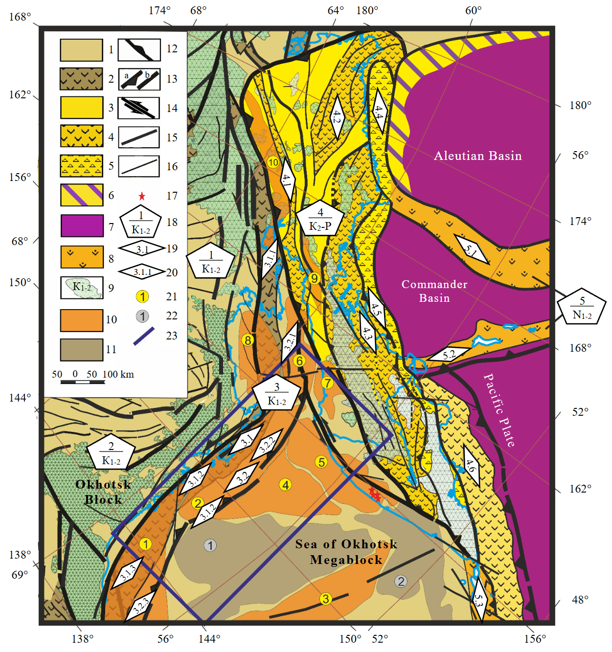
Fig.1. Scheme of tectonic zoning of consolidated basement and platform cover on the northern flank of the Sea of Okhotsk region [19]
1-9 – structural and material heterogeneities of consolidated basement: 1, 2 – Cimmerian FA (1 – blocks with continental-type crust, 2 – interblock (suture) megazones), 3-5 – Alpine FA (3 – blocks with continental-type crust; 4, 5 – interblock (suture) megazones: 4 – filled with volcanic sedimentary island-arc complexes, 5 – filled with accretionary prism formations), 6 – transitional continental-oceanic crust, 7 – oceanic crust, 8 – complexes of modern island arcs and underwater oceanic ridges, 9 – complexes of active continental margins; 10, 11 – structures of platform cover (10 – troughs, 11 – uplifts); 12 – subduction zones; 13-16 – faults (13 – boundaries of FA (a – overthrust, b – other), 14 – regional left-lateral shears, 15 – boundaries of structural zones, 16 – auxiliary faults); 17 – known gas condensate fields in the region; 18 – main geostructures (numerator – index, denominator – age of final folding); 19, 20 – indices of basement structures (19 – structures, 20 – fragments of structures); 21, 22 – indices of sedimentary cover structures (21 – troughs, 22 – uplifts); 23 – contours of the area of detailed studies
Structures of consolidated basement: 1 – Kolyma-Omolon FA; 2 – Verkhoyansk-Kolyma FA; 3 – Okhotsk-Chukotka collision-active marginal zone: 3.1 – Okhotsk-Chukotka suture zone (3.1.1 – Murgalskii, 3.1.2 – South-Taigonosskii, 3.1.3 – Tauiskii fragments), 3.2 – marginal fold-and-overthrust belt (3.2.1 – Shelikhovskii, 3.2.2 – Primagadanskii, 3.2.3 – Bilibinskii fragments); 4 – Koryak-Kamchatka accretion-collision-active marginal FA (4.1 – West Koryak, 4.2 – Central Koryak, 4.3 – Olyutorskaya, 4.4 – Khatyrskaya, 4.5 – Vetlovsko-Govenskaya, 4.6 – Kronotskaya zones); 5 – island arcs and ridges (5.1 – Shirshov Ridge, 5.2 – Aleutian-Commander, 5.3 – Kuril)
Sedimentary cover structures: 1-10 – troughs (1 – Shantaro-Lisyanskii, 2 – North Okhotsk, 3 – Central Okhotsk, 4 – Tinro, 5 – Okhotsk-West Kamchatka, 6 – Shelikhovskii, 7 – Voyampolskii, 8 – Gizhiginskii, 9 – Pustoretskii, 10 – Penzhinskii);
1, 2 – uplifts: 1 – Central Okhotsk, 2 – Bolsheretskoe
Along the western boundary of the Eurasian paleocontinent, the Okhotsk-Chukotka volcanic belt (OChVB) to 400 km wide is mapped. Superimposed on the structures of the Novosibirsk-Chukotka, Verkhoyansk-Kolyma and Kolyma-Omolon folded areas, the OChVB extends along the coast of the continent for more than 3000 km. In the anomalous magnetic field, such a structure is clearly manifested by linear chains of positive anomalies, sometimes exceeding 3000 nT, associated with volcanics of different composition – from salic to mafic varieties. In the gravity field, the OChVB is characterized by a change in sign from minus to plus and extended anomalies of northeastern strike.
Linear zonation of occurrence of the main structural and tectonic elements in the Kamchatka Peninsula is contrastingly manifested in the anomalous magnetic field. The character of magnetic field in the West Kamchatka zone is similar to that of the Sea of Okhotsk Megablock. Structures of Central and East Kamchatka are manifested in the anomalous magnetic field by meridionally elongated anomalies reaching the values of 2000 nT. The intensity and morphology of the magnetic field there are due to specific localization features of volcanic belts and island arc complexes attached to the continental margin in the Cenozoic. A similar linear zonation is also characteristic of the gravity field. The West Kamchatka zone is noted for a lower value of the gravity field corresponding to the development of a large sedimentary trough within its limits. Positive gravity field anomalies in the West Kamchatka Basin extending along the coastline are associated with uplifts of the basement surface [28]. A change in the sign of the field is observed when mapping the structures of the Central Kamchatka volcanic belt (by analogy with the OChVB); at the same time, the structures of Eastern Kamchatka are characterized by an alternating field of medium intensity.
The Aleutian and Commander basins, separated by the Shirshov Ridge, are emplaced on the oceanic basement with the structure of anomalous magnetic field and high values of gravity field with an intensity to 360 mGal, which is characteristic for this type of crust. They are separated from the Pacific Ocean Plate by the Aleutian-Commander Island Arc. High values of the gravity field in the oceanic basins are due to high density of the oceanic crust compared to the less dense continental crust.
Sea of Okhotsk marginal basin
Specific features of deep structure of the basin are determined by the successive development of the eastern flank of the Eurasian continent in the active continental margin regime, jamming of subduction zone by the Sea of Okhotsk continental plate and the final collisional processes of accretion of these continental plates [29, 30]. The accretion process in the Cretaceous-Middle Paleogene led to formation of fold-overthrust deformations on the margin of the Eurasian continent, formation of the OChVB, suture zone and regional left-lateral normal fault of the same name (Fig.1). The above structures can be traced from geophysical data along the entire northwestern coast of the Sea of Okhotsk [31].
In our work, special attention is paid to tracing regional shear zones and deformations feathering them and developing along the Okhotsk-Chukotka suture zone and the Okhotsk-West Kamchatka Block based on specific features of potential geophysical fields and their transformations. The identified shear zones determine the basement morphology and structural features of the sedimentary cover, which are associated with oil and gas potential of the Magadan region and West Kamchatka shelves. The principal shears are manifested by an abrupt change in infrastructure of the gravity and anomalous magnetic fields and specific features of their reference-free classification; feathering dislocations are usually marked by gradients of geophysical fields (Fig.2).
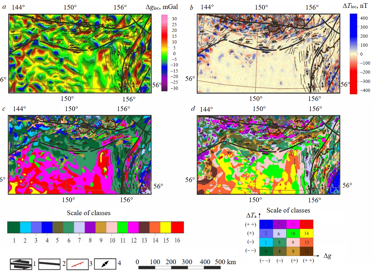
Fig.2. Schemes of local components and reference-free classification of gravity and anomalous magnetic fields in the northern Okhotsk region: local components of gravity (a) and magnetic (b) fields; reference-free classification of gravity and magnetic fields calculated using the algorithm of A.V.Petrov COSCAD 3D [23] (c) and the algorithm of D.S.Zelenetsky ASOD “Air” (d) [19]
Structure of consolidated basement. The Okhotsk-Chukotka regional shear with an extensive network of feathering deformations largely determines the specific features of deep structure of the consolidated basement and platform cover in the northern Sea of Okhotsk region. The position and morphology of the zone that we distinguished differ from the corresponding parameters of the East Asian global shear zone corroborated by the well-known researcher of this region V.P.Utkin [4, 5].
At the same time, we agree with him regarding the formation time of the shear zone (Jurassic – Early Cretaceous – “orogenic shear clustering”; Late Cretaceous – Cenozoic – “rift stretching of crustal blocks”). Formation of the shear zone, which we distinguished, dates back to the Late Cretaceous and is associated with lateral displacement of the Asian continent relative to the Pacific Oceanic Plate [5].
A similar infrastructure of tectonic deformations is also characteristic of the West Kamchatka shear zone. In this case, the axis of the principal shear has the northeastern strike, and horsts and grabens are oriented submeridionally, “synthetic” left-lateral shears are directed to the north-northwest.
Structures of platform cover. An important source of information on the structure of the sedimentary basins in Northern Okhotsk area and Western Kamchatka were the results of seismic surveying accomplished in the 1980s by OAO Dalmorneftegeofizika. As a result of processing seismic data, by experts of OAO Dalmorneftegeofizika, maps of four reference horizons were compiled corresponding to the main stages of restructuring of the basins [6]. A high quality and detail of these schemes allowed to consider them as a factual basis for assessing the character of tectonic deformations of the basement determining the structure of sedimentary depressions in the region. In order to study feathering dislocations of the principal Okhotsk-Chukotka left-lateral shear, the axes of horst and graben structures were manually drawn in the structure map of the acoustic basement surface (Fig.3), azimuths of the strike of their axial zones were measured, and the number of horsts and grabens, the axes of which are oriented at each ten-degree interval of the half-space, was counted. The results of analysis are displayed in the form of a rose diagram (Fig.4). The constructed rose diagram shows that the principal directions of fault dislocations and, accordingly, sedimentary depressions and horsts have sublatitudinal (azimuth 0-10°) and northwestern (azimuth 160-170°) directions. Dislocations with the strike azimuth 100-120° play a subordinate role. If we focus on parameters of the deformation ellipsoid of the left-lateral shear (Fig.5), then the sublatitudinal strike corresponds to the direction of the Okhotsk-Chukotka shear; north-west is the principal orientation of local horsts and grabens; dislocations with the strike azimuth 100-120°, most likely, represent feathering shears. Taking into account these conclusions and relying on results of a qualitative interpretation of geophysical fields, we constructed the geological scheme and the flow chart, where horsts and grabens of the platform cover are designated, the boundaries of which were differently oriented extension, compression faults and normal faults, the character of changes in the thickness of the Cenozoic cover was established and large sedimentary basins and local structures were outlined (Fig.5).
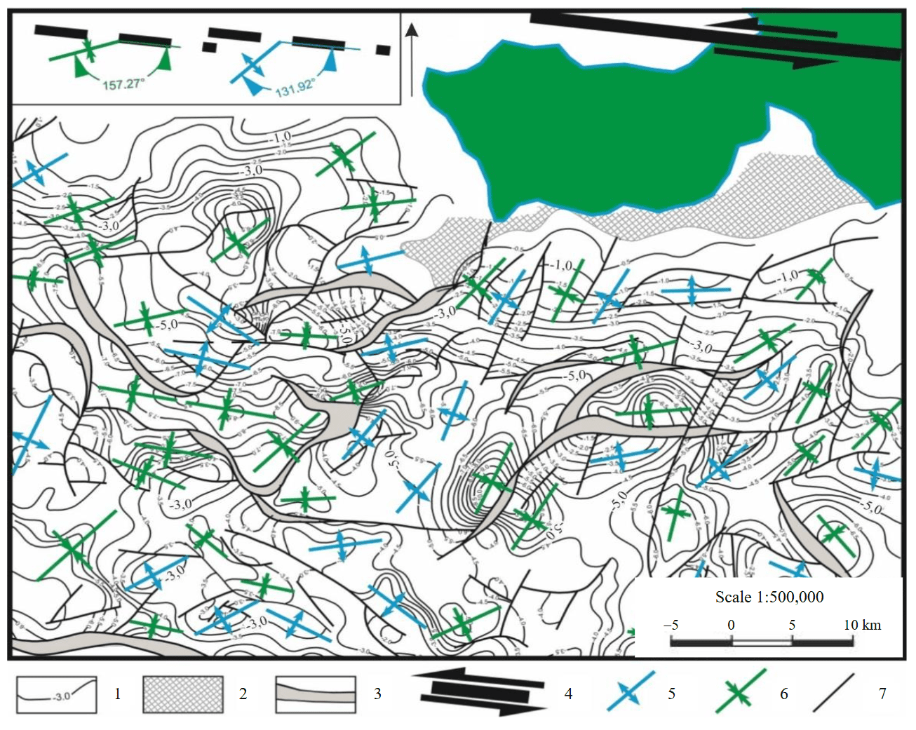
Fig.3. Scheme of the principal block axes relative to the Okhotsk-Chukotka left-lateral shear (a fragment of diagram based on data from OAO Dalmorneftegeofizika with additions by the authors); inset – measurement of angles between the principal shear and graben and horst axes
1 – isohypses of acoustic basement surface, km; 2 – exposures of acoustic basement on the sea floor; 3 – projection of the fault plane; 4 – fragment of the Okhotsk-Chukotka left-lateral shear; 5 – horsts; 6 – grabens; 7 – normal faults and upthrusts
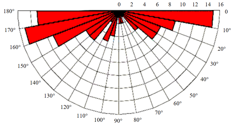
Fig.4. Orientation of the axes of normal faults and upthrusts in the development area of the Okhotsk-Chukotka shear [19]
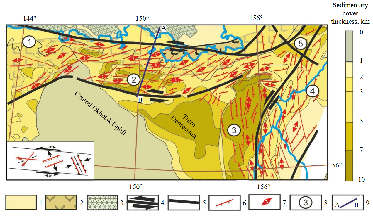
Fig.5. Spatial distribution pattern of fault extension and shear dislocations in the Okhotsk-Chukotka and West Kamchatka regional shear zones; inset – orientation of faults in the Okhotsk-Chukotka zone in accordance with the model of deformation ellipsoid of the left-lateral shear [19, 32]
Structural and material units: 1-3 – structures of Cimmerian fold areas (1 – blocks with continental crust, 2 – interblock suture zones, 3 – volcano-plutonic belt); 4 – main regional shears; 5 – faults-boundaries of structural zones; 6 – faults feathering regional shears (normal faults, shears); 7– axes of shear-pull-apart sedimentary cover structures; 8 – elements of oil and gas geological zoning (1 – Shantar-Lisyanskii Trough; 2 – North Okhotsk Trough; 3 – Okhotsk-West Kamchatka Trough; 4 – Voyampolskii Trough; 5 – Shelikhovskii Trough); 9 – position of geological and geophysical profile
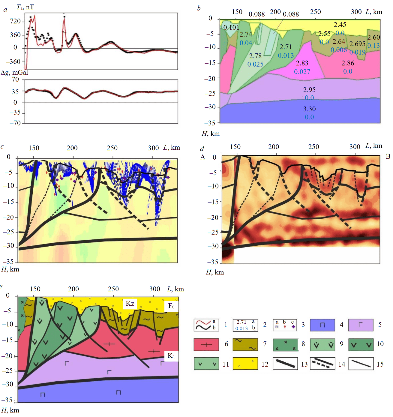
Fig.6. Construction of geological and geophysical section along A-B profile according to materials of interpretation of a set of geophysical data (see the position of the line in Fig.5): a – curves of anomalous magnetic ΔTа and gravity Δg fields; b – petrophysical model; c – “special” points of potential fields; d – seismic CDP section in reflectivity indicators; e – interpretation geological and geophysical section [19]
1 – curves of anomalous magnetic ΔTа and gravity Δg fields: theoretical (a), calculated (b); 2 – physical properties of rocks: density, g/cm3 (a), magnetic susceptibility, SI units (b); 3 – special points (effective sources) of potential fields: result of Euler deconvolution for gravity field (a), result of Werner deconvolution for magnetic field (b), result of Werner deconvolution for gravity field (c); 4 – lithospheric mantle; 5 – lower and middle crust; 6 – upper crust; 7 – ancient pre-Cenozoic sediments; 8 – intrusive massifs; 9-11 – suture zone complexes differentiated by density (9 – average, 10 – high, 11 – low values); 12 – Cenozoic sedimentary cover; 13 – boundaries of suture zone; 14 – main deep faults (in interpretation and resulting sections); 15 – secondary faults
Morphology of the sedimentary cover structures in the study area is largely determined by tectonic activity of the Okhotsk-Chukotka shear zone. The manifestation of this regional dislocation developing subparallel to the Eurasian coast led to emplacement of large longitudinal depressions and local horsts and grabens developing in a pull-apart mode.
Longitudinal shear basins in the development area of the Okhotsk-Chukotka shear zone are linear depressions (graben-rifts) extending sublatitudinally. It is in basins of this type that most of hydrocarbon resources of the Western Pacific region are localized. At the same time, the synrift complex is mainly composed of continental terrigenous coal-bearing formations and the supra-rift type – of coastal-marine, deltaic and deep-sea terrigenous and terrigenous-carbonate deposits of Meso-Cenozoic age [33]. A characteristic example of structures of this type is the large and relatively well-studied Magadan Trough, which is part of the North Okhotsk potential oil and gas area.
Parameters of the linear belt of local horsts and grabens developing parallel to the plate boundaries in the rear of the Pacific subduction zone, and the orientation of these structures correspond to the theoretical model of a pull-apart basin. Within the belt, extension, compression, and shear structures are modelled, their location agreeing well with the theoretical model of the left-lateral shear deformation ellipsoid [32]. The acute angle of horsts and grabens occurrence relative to the principal shear axis suggests that the left-lateral Okhotsk-Chukotka tectonic zone has a significant extension component.
Deep section. Deep structure of the consolidated basement was studied in the 2-DV-M geo-traverse section and was based on seismic surveying data (including deep CDP data) [22] as well as gravity and magnetic surveying data. The latter were interpreted using algorithms for solving inverse problems of gravity and magnetic surveying developed by A.B.Andreev and I.I.Priezzhev (COSKAD 3D) [23], M.B.Shtokalenko [34], A.I.Atakov [35] and Yu.P.Goryachev (BALTIKA) [36]. The calculation of special points of the field was performed using the Euler deconvolution method [37, 38]. Joint interpretation of the results of potential field inversion in combination with seismic surveying data made it possible to study the main features of the Earth's crust structure and morphological features of the basement and sedimentary cover structures. Figure 6, b shows the petrodensity and petromagnetic models of the Earth's crust section, the parameters of which in lateral dimension are verified by a correlation with the scheme of tectonic zoning of the consolidated basement (see Fig.1); in radial dimension – by the results of solving direct and inverse problems of geophysics. Reliability of modelling is illustrated by a high coincidence of the curves of the observed gravity and anomalous magnetic fields and the corresponding calculated curves (Fig.6, a). Figure 6, c demonstrates the association of special points with rift structures. Morphological features of the rift structure and the position of its deep channel show up on the routes of special points calculated using the Werner deconvolution algorithm.
The data of the CDP seismic surveying on the Magadan and West Kamchatka shelves, including those recalculated into “reflectivity” indices (Fig.6, d) [39], characterize the morphology of the platform cover boundaries and radial stratification of the consolidated basement. A comprehensive analysis of these different types of data allows to corroborate the morphology of the platform cover with identification of rift structures, and to model the Okhotsk-Chukotka suture zone and consolidated basement blocks at the margin of the Eurasian continent and the Sea of Okhotsk Megablock.
Discussion
The accomplished investigations indicate that tectonic deformations associated with the Okhotsk-Chukotka shear zone control the formation of an extensive network of feathering dislocations on the northern flank of the Sea of Okhotsk Megabasin [19]. In the Cenozoic, two types of basins formed in this belt: large longitudinal shear depressions and shear-pull-apart depressions oriented at an angle to the axis of the principal shear. In accordance with the classical model of left-lateral shear [32], a complete set of extension (rift grabens separated by horsts), compression, and shear structures are modelled there. In the section, “flower structures” are modelled characteristic of areas of shear deformation development with an extension component. Extensive occurrence of horsts and grabens within the Magadan shelf determined the formation of local structures – primary bodies for hydrocarbon exploration.
Geodynamic environment of formation of potential oil and gas-bearing structures. Long-term geological and geophysical studies of the continental part of Eurasia and waters of the Far East ensured a relatively high level of their exploration maturity. However, the accumulated factual material is geotectonically interpreted in an extremely diverse and contradictory manner. One of the most debatable issues is the assessment of the time and geodynamic environment of the formation of potential oil and gas structures in the Okhotsk region, which, from our point of view, is the key to deciphering the processes of hydrocarbon accumulation and conservation [27, 28]. This article presents the results of studying the localization pattern of faults as well as local uplifts and depressions of the platform cover in the area of influence of the Okhotsk-Chukotka and West Kamchatka regional shears, the spatial arrangement of which agrees with parameters of the deformation ellipsoid of the left-lateral shear [28].
Well-founded conclusions are of fundamental importance for prospecting on the northern flank of the Okhotsk OGP. It is in this region that a number of local anticlinal structures are identified in the license areas based on results of seismic surveying. The main prospects for oil and gas presence in the North Okhotsk Trough are associated with the Lower Cenozoic complex, which is in the principal oil formation zone (PK3-MK1) and has a significant generation potential [16]. Horst uplifts mapped in the course of investigations make it possible to justify the position of priority oil and gas exploration targets based on the structural criterion. It should be noted that the region faces the problem of discovering high-quality reservoirs.
Conclusion
The study of localization pattern of faults, horsts and grabens in the development area of regional shear zones of the North Okhotsk sedimentary basin allowed verifying the pattern of spatial arrangement of the Okhotsk-Chukotka and West Kamchatka regional normal faults and local structures of extension, compression, and shear feathering them.
Thus, in the area of influence of the Okhotsk-Chukotka shear zone, our studies established that sedimentary depressions and horsts have a northwestern strike (azimuth 160-170°); sublatitudinal structures are localized according to direction of the principal axis of the shear zone; dislocations with the strike azimuth 100-120° are, most likely, feathering shears. Similar conclusions about the structure of deformations and criteria of oil and gas potential were obtained for the area of the West Kamchatka shear zone.
The completed constructions expand the knowledge about the occurrence pattern of structures with hydrocarbon raw materials potential and new non-standard criteria of oil and gas presence in the region, which can be used to determine the directions of further prospecting and exploration work [40, 41]. These conclusions open the way to identifying the most potential (according to the structural criterion) areas with the aim of performing detailed prospecting within the northern flank of the Okhotsk OGP to determine areas with improved reservoir properties of rocks.
References
- Kharakhinov V.V. Sedimentary (oil and gas bearing and potentially oil and gas bearing) systems of the Sea of Okhotsk region: geodynamic arrangement. Russian Oil and Gas Geology. 2020. N 1, p. 81-99 (in Russian). DOI: 10.31087/0016-7894-2020-1-81-99
- Fangzheng Jiao, Yu Yang, Qi Ran et al. Distribution and gas exploration of the strike–slip faults in the central Sichuan Basin. Natural Gas Industry B. 2022. Vol. 9. Iss. 1, p. 63-72. DOI: 10.1016/j.ngib.2021.08.018
- Guang Zhu, Cheng Liu, Chengchuan Gu et al. Oceanic plate subduction history in the western Pacific Ocean: Constraint from late Mesozoic evolution of the Tan-Lu Fault Zone. Science China Earth Sciences. 2018. Vol. 61. Iss. 4. p. 386-405. DOI: 10.1007/s11430-017-9136-4
- Utkin V.P., Mitrokhin A.N., Nevolin P.L. Strike-slip related continental rifting of the eastern margin of Asia. Lithosphere. 2016. N 4, p. 5-29 (in Russian).
- Utkin V.P. Strike-slip related tectogenesis and structure-forming flow of crustal masses of the Asia-Pacific transition zone. Lithosphere. 2019. Vol. 19. N 5, p. 780-799 (in Russian). DOI: 10.24930/1681-9004-2019-19-5-780-799
- Petrovskaya N.A., Gretskaya E.V. Petroleum potential of Shelikhov sedimentary basin. Prospect and Protection of Mineral Resources. 2017. N 2, p. 31-37 (in Russian).
- Setiadi I., Setyanta B., Nainggolan T.B., Widodo J. Delineation of Sedimentary Subbasin and Subsurface Interpretation East Java Basin in the Madura Strait and Surrounding Area Based on Gravity Data Analysis. Bulletin of the Marine Geology. 2019. Vol. 34. N 1, p. 1-16. DOI: 10.32693/bomg.34.1.2019.621
- Mann P. Comparison of Structural Styles and Giant Hydrocarbon Occurrences within Four Active Strike-slip Regions: California, Southern Caribbean, Sumatra, and East China. Tectonics and Sedimentation: Implications for Petroleum Systems. American Association of Petroleum Geologists, 2012, p. 43-93. DOI: 10.1306/13351548M100861
- Caiwei Fan. Tectonic deformation features and petroleum geological significance in Yinggehai large strike-slip basin, South China Sea. Petroleum Exploration and Development. 2018. Vol. 45. Iss. 2, p. 204-214. DOI: 10.1016/S1876-3804(18)30024-7
- Zhang Jing, Li Wei, Wu Zhiping et al. Structural Characteristics of Tan-Lu Fault Zone in South Area of Bohai Sea and Its Control on Basin Structure. Earth Science. 2017. Vol. 42. N 9, p. 1549-1564. DOI: 10.3799/dqkx.2017.110
- Guang Zhu, Guo Sheng Liu, Man Lan Niu et al. Syn-collisional transform faulting of the Tan-Lu fault zone, East China. International Journal of Earth Sciences. 2009. Vol. 98. Iss. 1, p. 135-155. DOI: 10.1007/s00531-007-0225-8
- Smit J., Brun J.-P., Cloetingh S., Ben-Avraham Z. Pull-apart basin formation and development in narrow transform zones with application to the Dead Sea Basin. Tectonics. 2008. Vol. 27. Iss. 6. N TC6018. DOI: 10.1029/2007TC002119
- Schattner U., Weinberger R. A mid-Pleistocene deformation transition in the Hula basin, northern Israel: Implications for the tectonic evolution of the Dead Sea Fault. Geochemistry, Geophysics, Geosystems. 2008. Vol. 9. Iss. 7. N Q07009. DOI: 10.1029/2007GC001937
- Heimann A., Zilberman E., Amit R., Frieslander U. Northward migration of the southern diagonal fault ofthe Hula pull-apart basin, Dead Sea Transform, northern Israel. Tectonophysics. 2009. Vol. 476. Iss. 3-4, p. 496-511. DOI: 10.1016/j.tecto.2009.07.024
- Arkle J.C., Weber J., Enkelmann E. et al. Exhumation of the Coastal Metamorphic Belt Above the Subduction-to-Transform Transition, in the Southeast Caribbean Plate Corner. Tectonics. 2021. Vol. 40. Iss. 8. N e2020TC006414. DOI: 10.1029/2020TC006414
- Margulis L.S., Podolsky Yu.V., Borovikov I.S., Pylina L.M. The current state and challenges of replacement of the hydrocarbon resource base. Mineral Resources of Russia. Economics and Management. 2013. N 5, p. 19-49 (in Russian).
- Ignatova V.A. Comparison of Geodynamic Models and the Hydrocarbon Potential of Sedimentary Basins in the Russian Far East and SE Asia. Russian Journal of Pacific Geology. 2010. Vol. 4. N 2, p. 116-130. DOI: 10.1134/S1819714010020028
- Alekseev V.I. Deep structure and geodynamic conditions of granitoid magmatism in the Eastern Russia. Journal of Mining Institute. 2020. Vol. 243, p. 259-265. DOI: 10.31897/PMI.2020.3.259
- Bolshakova N.V. Deep structure of the northern flank of the Okhotsk oil and gas province based on complex geological and geophysical studies: Avtoref. dis. ... kand. geol.-mineral. nauk. SPb: Sankt-Peterburgskii gornyi universitet, 2022, p. 20 (in Russian).
- Kashubin S.N., Petrov O.V., Shokalsky S.P. et al. Deep crustal structure in Northeastern Eurasia and its continental margins. Geodynamics & Tectonophysics. 2021. Vol. 12. Iss. 2, p. 199-224 (in Russian). DOI: 10.5800/GT-2021-12-2-0521
- Pavlenkova N.I., Kashubin S.N., Gontovaya L.I., Pavlenkova G.A. Deep structure and geodynamics of the Sea of Okhotsk region. Regional Geology and Metallogeny. 2018. N 76, p. 70-82 (in Russian).
- Sakulina T.S., Kalenich A.P., Atakov A.I. et al. Geological model of the Okhotsk Sea region according to basic profiles 1-OM and 2-DW-M. Prospect and Protection of Mineral Resources. 2011. N 10, p. 11-17 (in Russian).
- Petrov A.V., Yudin D.B., Khou Syueli. Processing and interpretation of geophysical information by methods of probabilistic-statistical approach using “Koskad 3D” computer technology. Bulletin of Kamchatka Regional Association “Educational-Scientific Center”. Earth Sciences. 2010. Vol. 16. N 2, p. 126-132 (in Russian).
- Danilev S.M., Sekerina D.D., Danileva N.A. Localization of sites for the development of geomechanical processes in underground workings based on the results of the transformation and classification analysis of seismic data. Journal of Mining Institute. 2024. Vol. 266, p. 260-271.
- Yakovleva A.A., Movchan I.B., Medinskaia D.K., Sadykova Z.I. Quantitative interpretations of potential fields: from parametric to geostructural recalculations. Bulletin of the Tomsk Polytechnic University. Geo Assets Engineering. 2023. Vol. 334. N 11, p. 198-215 (in Russian). DOI: 10.18799/24131830/2023/11/4152
- Yakovleva A.A., Movchan I.B., Shaygallyamova Z.I. Dynamic response of multi-scale geophysical systems: waves and practical applications. Philosophical Transactions of the Royal Society A. 2022. Vol. 380. Iss. 2237. N 20210403. DOI: 10.1098/rsta.2021.0403
- Shapiro M.N., Solovev A.V. Formation of the Olyutorsky-Kamchatka foldbelt: a kinematic model. Russian Geology and Geophysics. 2009. Vol. 50. N 8, p. 668-681. DOI: 10.1016/j.rgg.2008.10.006
- Kalinin D.F., Egorov А.S., Bolshakova N.V. Oil and gas potential of the West Kamchatka coast and its relation to the structural and tectonic structure of the Sea of Okhotsk region based on geophysical data. Bulletin of Kamchatka Regional Association “Educational-Scientific Center”. Earth Sciences. 2022. Vol. 53. N 1, p. 59-75 (in Russian). DOI: 10.31431/1816-5524-2022-1-53-59-75
- Krikun N.S., Babenko I.A., Talovina I.V., Duriagina A.M. Geological Structure and Perspectives of Oil and Gas Bearing in Neogene Sediments of the Southern Part of the Kuril Island Arc System. Russian Journal of Earth Sciences. 2024. Vol. 24. Iss. 2. N ES2001 (in Russian). DOI: 10.2205/2024es000905
- Krikun N.S., Abdrahmanov I., Talovina I. Study of the Faults Network of Kunashir Island (Kuril Islands) in Order to Reconstruct the Features of its Tectonic Evolution. Russian Journal of Earth Sciences. 2024. Vol. 24. Iss. 2. N ES2012 (in Russian). DOI: 10.2205/2024es000915
- Egorov A.S., Bolshakova N.V., Kalinin D.F., Ageev A.S. Deep structure, tectonics and geodynamics of the Sea of Okhotsk region and structures of its folded frame. Journal of Mining Institute. 2022. Vol. 257, p. 703-719. DOI: 10.31897/PMI.2022.63
- Park R.G. Geological Structures and Moving Plates. Springer, 1988, p. 337.
- Belonin M.D., Grigorenko Yu.N., Margulis L.S. et al. Exploration potential of Western Kamchatka and adjacent shelf (oil and gas). St. Petersburg: Nedra, 2003, p. 120 (in Russian).
- Alekseev S.G., Senchina N.P., Shatkevich S.Yu., Shtokalenko M.B. Advantages and disadvantages of potential field tomography. Voprosy teorii i praktiki geologicheskoi interpretatsii geofizicheskikh polei: Materialy 43-i sessii Mezhdunarodnogo nauchnogo seminara im. D.G.Uspenskogo, 26-30 yanvarya 2016, Voronezh, Rossiya. Voronezh: Izdatelsko-poligraficheskii tsentr “Nauchnaya kniga”, 2016, p. 10-13 (in Russian).
- Dmitrieva L.K., Atakov A.I., Matveev Yu.I., Roslov Yu.V. Creation of geophysical support for Gosgeolkarta-1000/3 and study of deep structure of the shelf of the Russian Federation by geotraverses. Regional Geology and Metallogeny. 2007. N 33, p. 76-78 (in Russian).
- Goryachev Yu.P., Dobrynina M.I. New possibilities of the BALTIKA interpretation system in prospecting for explosion tubes based on aeromagnetic survey materials. Geofizika. 2003. N 3, p. 64-66 (in Russian).
- Senchina N.P., Asoskov A.E., Gorelik G.D. Evaluation of Displacements Caused by Strike-Slip Deformations Using Correlation Characteristics Based on Potential Field Data. Russian Journal of Earth Sciences. 2023. Vol. 23. Iss. 4. N ES4013. DOI: 10.2205/2023ES000847
- Senchina N.P., Asoskov A.E. Reconstruction approach to the interpretation of strike-slip structures from geophysical data. Nedropolzovanie XXI vek. 2023. № 5-6 (101), p. 50-57 (in Russian).
- Sysoev A.P., Zaitsev S.A. Separate issues of amplitude inversion of wave field. Geology and mineral resources of Siberia. 2023. N 3 (55), p. 52-58 (in Russian). DOI: 10.20403/2078-0575-2023-3-52-58
- Litvinenko V. The Role of Hydrocarbons in the Global Energy Agenda: The Focus on Liquefied Natural Gas. Resources. 2020. Vol. 9. Iss. 5. N 264. DOI: 10.3390/resources9050059
- Prischepa O.M., Kireev S.B., Nefedov Yu.V. et al. Theoretical and methodological approaches to identifying deep accumulations of oil and gas in oil and gas basins of the Russian Federation. Frontiers in Earth Science. 2023. Vol. 11. N 1192051. DOI: 10.3389/feart.2023.1192051