
Assessment of the ecological state of aquatic ecosystems by studying lake bottom sediments
- 1 — Ph.D. Senior Researcher Empress Catherine II Saint Petersburg Mining University ▪ Orcid
- 2 — Ph.D. Senior Researcher Institute of Limnology of the RAS – Saint Petersburg Federal Research Center of the RAS ▪ Orcid
Abstract
The article presents the results of coupled palynological and geochemical studies of five various genesis lakes, located along the route of the expedition “In the footsteps of Alexander von Humboldt in Siberia, Altai and Eastern Kazakhstan”, dedicated to the double anniversary: the 190th anniversary of the expedition across Russia of the famous scientist and his 250th birthday. A geochemical analysis of water and bottom sediments of Ik Lake (Siberia), Lakes Kolyvanskoe and Beloe (Altai), Lake Bezymyannoe (Kazakhstan) and Nagornyi Pond (Altai) was carried out. Based on their results an assessment of studied lakes ecological state was given through single and integral criteria. A high level of pollution was noted for Nagornyi Pond and Lake Bezymyannoe, which is caused by a significant technogenic load from nearby mines. This is consistent with the data of palynological research. The aquatic ecosystems of Lakes Kolyvanskoe and Beloe are characterized by a satisfactory ecological situation, but they experience an increased recreational load. The results of spore-pollen analysis and analysis of non-pollen palynomorphs showed the low ability of these lakes to self-healing. The most favorable ecological state and high self-cleaning capacity were noted for Lake Ik, which is consistent with the data of palynological studies. It is being confirmed with the results of palynological studies. It was therefore concluded about the ability to make a quick assessment of the aquatic ecosystems’ ecological state by studying lakes using coupled palynological and geochemical analysis.
Research is executed within the State task N FSRRW-2023-0002; FMNG-2019-0004
Introduction
In May-June 2019, the Russian-German expedition “In the Footsteps of Alexander von Humboldt in Western Siberia, Altai and Eastern Kazakhstan”, dedicated to the 250th anniversary of the birth of the outstanding scientist and the 190th anniversary of his expedition to Russia, took place within the framework of a joint project of St. Petersburg Mining University, Freiberg Mining Academy and the St. Petersburg Union of Scientists. Among the various objects (outcrops, rocks, dumps, soils, landscapes) along the route of the expedition lakes were studied.
For a comprehensive assessment of an aquatic ecosystem, it is necessary to know the indicators of water and its biotic part [1]. Bottom sediments as a depositing medium are also instrumental in assessing the state of a water body [2]. They accumulate chemical elements and provide information about the ecological condition of the catchment area. Bottom sediments are an important source of information about past climatic and geochemical conditions, allowing assessing the ecological state of air and water [3, 4]. They actively accumulate pollutants and can become a source of secondary pollution of water bodies. Heavy metals intensively accumulating in bottom sediments are among the most dangerous pollutants [5]. Water and bottom sediments were sampled with subsequent chemical and spore-pollen analyses for express-assessment of the ecological state of lakes. Palynological studies of lake sediments provide additional information for assessment of the regional geochemical background [6]. When comparing the results of surface samples analyses with modern vegetation, discrepancies are often revealed. Their analysis makes it possible to draw conclusions about changes in the vegetation cover under the influence of technogenesis [7, 8].
Study area
The authors investigated lakes of different types (in terms of genesis, size, water balance and chemical composition) on the border of forest and forest-steppe zones of Siberia, Ore Altai and Kazakhstan (Fig.1).
Ik Lake is located in Krutinskii District of Omsk Oblast in the south of the West Siberian Plain in the interfluve of the Ishim and Irtysh Rivers. It is a part of the system of The Big Krutinsk Lakes (Ik, Saltaim, Tenis) belonging to the Irtysh Lake and River system. The shape of the lake is round, slightly elongated from southwest to northeast, length 12 km, width 8 km, length of the shoreline 36.2 km. The origin of the basin is glacial. The mirror area is 71.4 km² and the catchment area is 1190 km². The bottom is flat, the depth increases smoothly towards the middle, the average depth is 2.7 m, maximum 4.7 m. The shores are steep and composed of coastal-alluvial deposits of sands with interlayers of clays with underlying siltstones and sandstones [9]. Since southwesterly winds prevail on Ik Lake, the northeastern and eastern shores are subject to abrasion and serve as a source of Ca, Mg, Fe, and Al inputs to the water. Aquatic vegetation zonally encircles the lake. At the water's edge there are various species of sedges, arrowleaf, chasteberry, plantain, amphibian buckwheat, teloresis. Then there is a zone of cattail and reed. The water supply of the lake is supported by the Yaman and Krutikha Rivers, as well as by atmospheric precipitation. The mouth of the Krutikha River is heavily silted, and in dry years the water flow is insignificant. The Kiterma River flows out of the lake, connecting Ik Lake with Saltaim Lake. There is a dam at its source, which maintains the water level in the lake. The watershed is located in the forest-steppe zone [9]. The settlements of Kiterma, Ust-Kiterma, Krutinka and Yaman are located along the perimeter of the lake. Farms, summer cattle camps, cultivated fields and unauthorized dumps are concentrated in them. Surface runoff from these areas is a source of pollution of the lake with Al, Fe, Cu, Mn and nutrients. The lake is also experiences recreational load. Three surface samples of bottom sediments were taken from Ik Lake and water samples were taken at the same points.
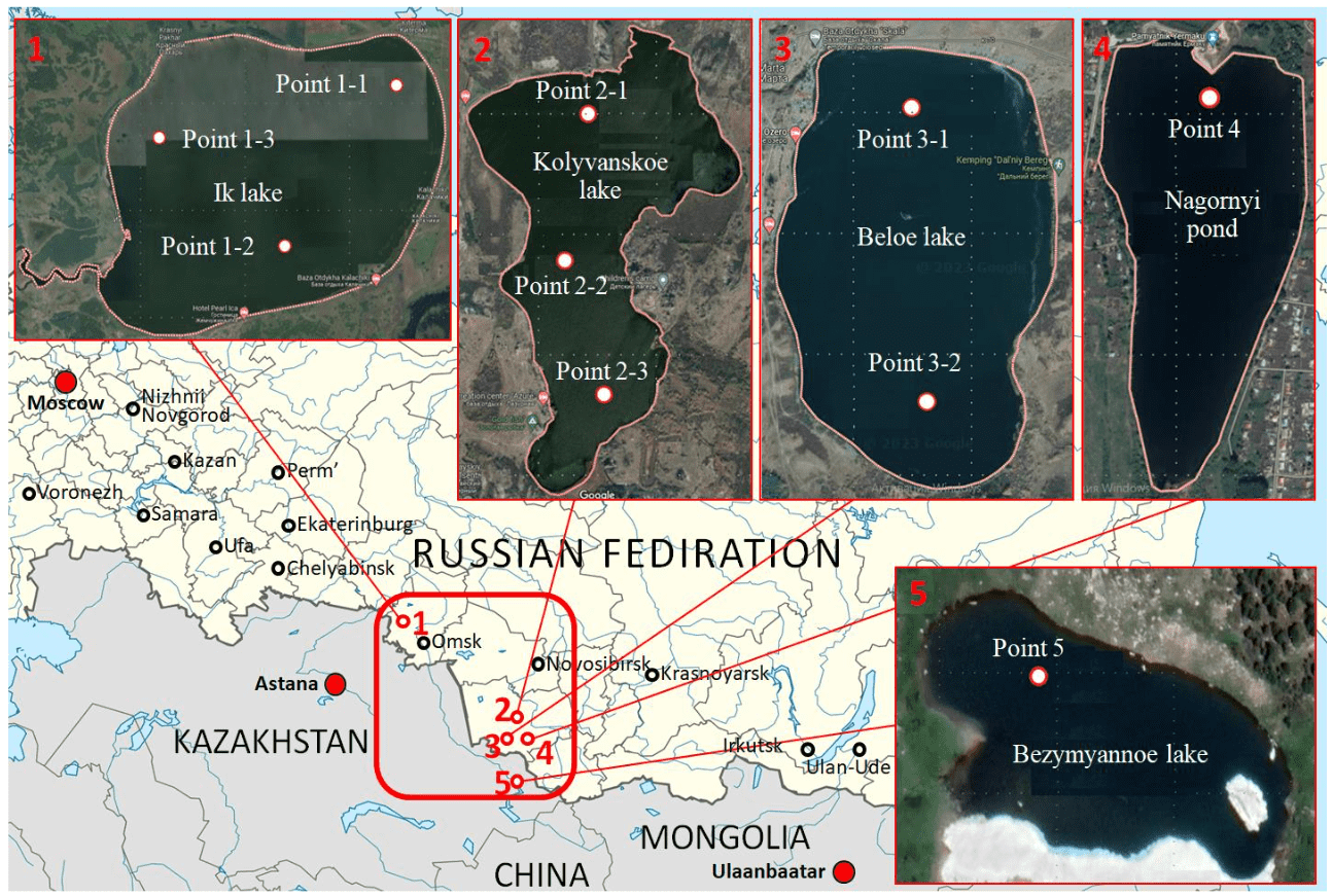
Fig.1. Study area with sampling points (based on Google maps)
Kolyvanskoe Lake is located at the foot of the northern slope of the Kolyvanskii Ridge in the Zmeinogorskii District of Altai Region. The regional background of Zn, Cr, and Cu is elevated here as a result of many years of active mining of polymetallic ores. The lake has an irregular shape and is stretches from north to south. Its length is 4 km with a width from 0.5 to 2.5 km, the average depth is 1.8 m and the maximum depth is 4.1 m [10]. The origin of the basin is presumably tectonic. The water mirror area is 4.5 km2, the catchment area is 55.7 km2. The shores are gentle, low, in some places overgrown with bushes. The Kolyvanka River flows into the Kolyvanskoe Lake from the east, the Pochtovyi Stream from the west and The Ust-Kolyvanka River flows out from the north [11]. Kolyvanskoe Lake is a geological and landscape natural monument of regional significance. It is characteri-zed by rich and diverse flora and unique vegetation. It is inhabited by a rare species (tertiary relict) of water nut. The banks are dominated by pinnate sagebrush, hair grass, valis fescue, steppe bluegrass, goniolimon. There are dense thickets of bushes (common bird cherry, cotoneaster, Siberian barberry, Tatar honeysuckle); there are birch and common pine in some places. Ash-leaved maple, which belongs to the adventive species, is widespread. Kolyvanskoe Lake suffers from a high recreational load. As a result of many years of unorganized recreation and tourism, landscapes are significantly disturbed. The priority pollutants entering the lake with surface runoff are Fe, Cu, Al, Zn, Pb, Cr and biogenic elements. Three surface samples of bottom sediments and at one point a water sample were taken at the lake.
Nagornyi Pond is located in Zmeinogorsk, Altai Krai, at the southern foot of the Kolyvan Ridge. It was created in the floodplain of the Zmeyevka River in 1786 according to the project of hydraulic engineer K.D.Frolov [12]. The dam built on it flooded an earlier dam upstream and formed a pond fed by the river, several springs and rain waters. The mirror area is 7.5 km2. At present, the dam and part of the structures for ore lifting and mine water pumping have been preserved. The main source of anthropogenic impact is the Zmeinogorsk polymetallic mine, which operated in the XVIII-XX centuries and was mothballed. Recultivation of dumps and mine workings was not carried out, so the pollution of the pond has aerogenic (as a result of dusting) and hydrogenic (as a result of infiltration of atmospheric precipitation through the thickness of disturbed rocks) character [13, 14]. The main potential pollutants are Fe, Zn, Cu, Cr, Ni, Cd, Ti. One sample of bottom sediments and a water sample were taken from the Nagornyi Pond.
Beloe Lake is located in a wide basin of the Kolyvanskii Ridge in the Kuryinskii District of Altai Krai. It has an oval shape with the size of 2.4 by 1.2 km, average depth of 4.5 m and maximum depth of 7.4 m [15]. The origin of the basin is tectonic. The mirror area is 2.7 km2, the catchment area is 14.2 km2. The lake lies in granite shores from the south and in shale shores from the east and north. Beloe Lake belongs to the basin of the Belaya River. Beloe Lake belongs to the basin of the Loktevka River, a left tributary of the Charysh River. It is connected with the Belaya River by an artificial canal. At the mouth of the canal there is a concrete dam regulating water flow [16]. Ozernyi Stream in the southeast and Bezymyannyi Stream in the northeast flow into the lake. Mountain-steppe vegetation is widespread in the vicinity, with a pine forest approaching from the northwest. The following plants grow along the banks: southern reed, lake reed, amphibian mountain, submerged hornwort, shiny and curly radish. In the recreational load on the lake ecosystem the share of unorganized tourism is high, especially in summer months. The southeastern part of the coast is used for hayfields. Since 2010 the lake has the status of a natural monument within the boundaries of the shoreline. Since 2013 the company “Eco-vector” has been extracting sapropel from the lake. Two samples of bottom sediments and a water sample were taken from the lake.
Bottom sediments were also sampled at Bezymyannoe Lake, located in the Rudnyi Altai in a mountain basin at the foot of the Ivanovskii Ridge, 30 km from Ridder (Kazakhstan). The lake is drainless and has no tributaries. From the western side it is framed by outcrops of calcareous and siliceous siltstones and microquartzites, presumably of the Kryukov Formation, up to 25-30 m thick. Along the faults, the rocks are locally altered by superimposed hydrothermal processes. In the Ridder district, they formed rich polymetallic ores mined by several mines [17]. Scattered disseminated mineralization of sphalerite, galena and chalcopyrite was recorded in the studied outcrop. In the oxidation zone, these minerals are actively decomposed and, as a result of wind and water erosion, may serve as a source of Zn, Pb, Cu, and Fe contamination of surface waters [18]. The lake may also experience anthropogenic load from the existing mining enterprise in Ridder. The prevailing wind direction according to long-term meteorological observations is westerly (38 %), which contributes to the aerotechnogenic transfer of pollutants from the territory of mines and dumps [19]. The main potential pollutants are Fe, Zn, Cu, Mn, Pb, Cr, Cd, and Ni.
The sedimentation rate in the studied lakes is 0.3-0.35 cm/year [9].
Methods
Water samples were collected from a boat and from the shores of small lakes from a depth of 10-30 cm from the surface into polyethylene containers. Immediately at the sampling site, non-stable water quality indicators such as temperature, salinity and pH were determined using a WTW MULTI 350I multimeter with a set of electrodes. In accordance with GOST R 59024-2020, one part of the sample was acidified with nitric acid to pH less than 2, and the other part was left in its natural state. After that the samples were cooled to +4 °C for transportation and further analysis in laboratory conditions.
Bottom sediments were sampled with a Voronkov lot into polyethylene containers at the same points as the water samples, and then cooled to +4 °C for further transportation. The thickness of the sampled sediment layer was 2.5-3 cm. Palynological analysis of bottom sediments was carried out in laboratory conditions to characterize the vegetation of lakes and their catchments, and also their chemi-cal composition was determined: organic, inorganic and total carbon C on TOC-V (Shimadzu), water-soluble, mobile and gross forms of heavy metals according to MVI-80-2008. Also for bottom sediments the losses on ignition and pH of water extract were determined according to GOST 26423-85.
Quantitative chemical analysis of water was performed in the accredited laboratory “Environmental Modeling” of Saint Petersburg Mining University. Metal concentrations were determined by atomic emission spectrometry with inductively coupled plasma on ICPE-9000 (Shimadzu) according to M-02-1109-09, anions – by chromatographic method on LC-20 Prominence (Shimadzu) by ion chromatography according to M-02-1805-09.
Spore-pollen analysis of bottom sediments was carried out at the Institute of Limnology of the Russian Academy of Sciences. Samples were processed using heavy liquid according to the method of V.P.Grichuk and tested for carbonation using hydrochloric acid. Only the sample from Nagornyi Pond was found to be weakly carbonate. Pollen and spores were identified according to the identifiers of L.A.Kupriyanova, L.A.Alyoshin and P.D.Moore, J.A.Webb, M.E.Collinson, as well as with the help of material collections of the Institute of Limnology of the Russian Academy of Sciences. To reconstruct the state of the lake ecosystem, non-dust palynomorphs [20], green algae Botryococcus braunii and Pediastrum, fungal spores, plant stomata, remains of microfauna, rhizopods, microparticles of coals, etc. were determined in each sample [21].
Quantitative chemical analysis of bottom sediments was carried out in the accredited laboratory “Environmental Modeling” of Saint Petersburg Mining University. Bottom sediment samples were dried at room temperature to air-dry condition in a well-ventilated place and in the absence of direct sunlight, while minimizing the possibility of secondary contamination. After that, foreign particles (pebbles, debris, algae, etc.) were removed from the air-dry samples using tweezers. The cleaned sample was ground in an agate mortar. Determination of moisture content and losses on ignition was carried out on the thermogravianalyzer TGA 701 by LECO according to R 52.24.763-2012.
Metals were considered as priority pollutants in bottom sediments [22, 23]. Decomposition of samples to determine the gross content of metals was carried out in a microwave system with a mixture of hydrochloric, nitric, hydrofluoric and boric acids. The mobile forms were extracted with acetate and ammonium buffer solution with pH = 4.8. For determination of water-soluble forms, aqueous extracts were prepared based on bidistilled water. Acid decomposition products and extracts were analyzed by atomic absorption and atomic emission spectrometry methods according to MVI-80-2008. The pH value was also determined in aqueous extracts.
Discussion of results
All the studied lakes are fresh with neutral pH level. According to O.A.Alekin's classification, by predominant anion they belong to hydrocarbonate; by predominant cation – Ik Lake belongs to sodium, the others – to calcium. Ik Lake and Kolyvanskoe Lake belong to the highest category, Beloe Lake – to the first category of fishery importance; Nagornyi Pond and Bezymyannoe Lake are water bodies of cultural and domestic importance. Comparison of the results with MACs for the respective categories of water use showed exceedances for Fe (KMAC = 3), Mn (9), Al (3) and Cu (15) in Kolyvanskoe Lake; for Mn (3) and Cu (30) in Beloe Lake; for Sr (1.5) and Cu (60) in Ik Lake. No exceedances were recorded in Nagornyi Pond and Bezymyannoe Lake, which is associated with more “soft” norms for water bodies of cultural and domestic importance.
Relative to the conditionally background values for lakes of the forest-steppe zone of Western Siberia, obtained from the results of the study of the chemical composition of the 130 small lakes (that are not directly under the influence of anthropogenic impact) [24, 25], the following chemical elements were found: the increased content of Cu (Kbackground = 6.8), Co (2) and Cr (1.2) in Ik Lake; Al (2.6), Zn (2.3), Cu (2), Cr (1.8) and Fe (1.5) in Kolyvanskoe Lake; Co (1.5), Cr (2), Cu (3.3) and Zn (1.8) – in Beloe Lake; Fe (4), Al (3.1), Cu (4.5), Cr (4.5), Zn (2.2), and Ni (1.8) – in Pond Nagornyi; Cu (7), Cr (4.2), Zn (3.1) and Ni (2.4) – in Bezymyannoe Lake.
The results of the spore-pollen analysis (arithmetic mean values for three samples) are presented in Table 1, according to which the lake landscapes of Nagornyi Pond and Bezymyannoe Lake are classified as forest, and those of Ik Lake and Kolyvanskoe Lake as forest-steppe.
Table 1
Spore-pollen spectra composition of surface samples of the studied water bodies
|
Water body |
Tree pollen, % |
Grass pollen, % |
Spores, % |
|
Ik Lake |
61 |
38 |
1 |
|
Kolyvanskoe Lake |
43 |
53 |
4 |
|
Nagornyi Pond |
73 |
25 |
2 |
|
Bezymyannoe Lake |
70 |
30 |
0 |
Pollen of birch and pine prevails among tree species in the spore-pollen spectra of Ik Lake and Kolyvanskoe Lake. Pollen of fir and pine with a significant admixture of birch and a small admixture of spruce prevails in the spore-pollen spectra of Bezymyannoe Lake. Pine pollen absolutely dominates in Nagornyi Pond, which is partially introduced in all cases, as it is very volatile and is transported to the maximum distance relative to all other pollen grains. Grass pollen in Ik Lake and Kolyvanskoe Lake is represented mainly by cereals and artemisia, in Bezymyannoe Lake and Nagornyi Pond – by cereals and sedges. Pollen of ruderal grasses was detected in all samples, except for the bottom sediments of Ik Lake. The maximum pollen content of aquatic and coastal aquatic plants was detected in Kolyvanskoe Lake.
Non-pollen palynomorphs in all bottom sediment samples are represented by green algae Pediastrum, remains of microfauna, fungi spores and coal microparticles. No species of Pediastrum algae were found in the surface samples of Bezymyannoe Lake. Their maximum content was found for Ik Lake, with the highest diversity of species noted for Kolyvanskoe Lake (Fig.2). In Kolyvanskoe Lake green algae are also represented by Botryococcus braunii and diatoms, in Nagornyi Pond – mainly by diatoms. Spores of ferns and horsetails were recorded in Ik Lake and Nagornyi Pond. A small number of shell amoebae was detected only in Nagornyi Pond. The maximum content of charcoal microparticles and minimum microfauna was noted for Bezymyannoe Lake, Elodea pollen was also detected there. Plantago and Cerealia were found in small amounts in the bottom sediments of Ik Lake.
The results of chemical analysis of bottom sediments for the content of gross, mobile and water-soluble forms of metals are presented in Table 2. The values of losses on ignitions and hydrogen index of water extract are presented in Table 3.
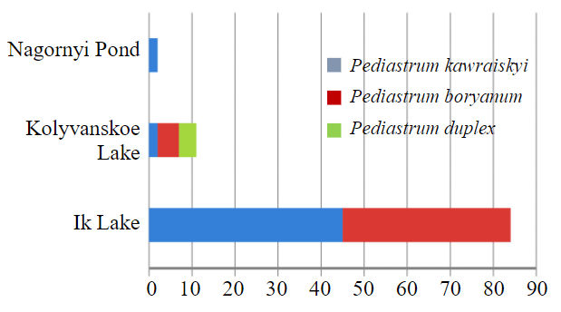
Fig.2. Content of different species of Pediastrum algae in surface samples of the studied water bodies
Table 2
Content of gross, mobile and water-soluble forms of metals in the studied bottom sediment samples
|
Element |
MAC (APC)* gross / mobile form |
Metal content: gross / mobile / water-soluble forms, ppm** |
|||||||||||||
|
Ik Lake |
Kolyvanskoe Lake |
Nagornyi Pond |
Bezymyannoe Lake |
||||||||||||
|
Al |
n/s |
22850 |
13.1 |
11.3 |
45057 |
81 |
5.6 |
19624 |
27 |
26 |
34184 |
28 |
13 |
||
|
Ba |
n/s |
175 |
6.8 |
0.95 |
325 |
10 |
1.7 |
1731 |
76 |
1.1 |
170 |
22 |
0.67 |
||
|
Cd |
0.5 |
n/s |
1.4 |
0.49 |
0.17 |
2.4 |
1.2 |
0.16 |
3.8 |
1.2 |
0.12 |
4.4 |
1.1 |
0.095 |
|
|
Co |
n/s |
5.0 |
3.1 |
0.87 |
0.39 |
16 |
1.8 |
0.51 |
14 |
3.0 |
0.20 |
27 |
5.2 |
0.28 |
|
|
Cr |
0.05 |
n/s |
18 |
0.13 |
0.058 |
73 |
0.53 |
0.0093 |
46 |
0.38 |
0.088 |
49 |
0.43 |
0.060 |
|
|
Cu |
33 |
3 |
3.6 |
0.57 |
0.079 |
42 |
1.9 |
0.20 |
34 |
2.6 |
0.48 |
83 |
11 |
0.75 |
|
|
Fe |
n/s |
n/s |
7017 |
75 |
15 |
52152 |
1983 |
0.89 |
27352 |
680 |
37 |
46897 |
280 |
11 |
|
|
Mn |
1500 |
80 |
171 |
16 |
0.44 |
481 |
77 |
19 |
785 |
523 |
1.4 |
1655 |
303 |
0.78 |
|
|
Ni |
n/s |
4.0 |
15 |
0.28 |
0.072 |
51 |
3.1 |
0.18 |
25 |
1.4 |
0.18 |
38 |
1.3 |
0.15 |
|
|
Pb |
32 |
6.0 |
8.0 |
0.27 |
< 0.25 |
8.4 |
0.88 |
< 0.25 |
4.3 |
0.33 |
< 0.25 |
4.1 |
0.28 |
< 0.25 |
|
|
Sr |
n/s |
85 |
12 |
3.7 |
131 |
20 |
4.6 |
336 |
183 |
13 |
114 |
35 |
2.6 |
||
|
Ti |
n/s |
2523 |
0.92 |
0.89 |
5387 |
0.99 |
0.18 |
3834 |
0.52 |
0.28 |
4754 |
0.57 |
0.30 |
||
|
Zn |
55 |
23 |
6.7 |
1.7 |
0.058 |
81 |
6.8 |
1.0 |
86 |
7.1 |
0.25 |
366 |
72 |
0.24 |
|
* The MPC and APC values are adopted according to SanPiN “On approval of sanitary regulations and standards SanPiN 1.2.3685-21 “Hygienic standards and requirements for ensuring the safety and (or) harmlessness of environmental factors to humans”; n/s – the indicator is not standardized.
** Arithmetic mean values for three samples; bold numbers – values exceeding MAC (APC) values.
Table 3
Losses on ignition and pH of aqueous extract of the studied bottom sediment samples
|
Indicator |
Ik Lake |
Kolyvanskoe Lake |
Nagornyi Pond |
Bezymyannoe Lake |
|
Losses on ignition, % |
16.3 |
14.4 |
9.04 |
6.04 |
|
pH |
6.66 |
6.36 |
7.17 |
6.88 |
Bottom sediments sampled at Beloe Lake are more than 90 % sandy fraction (d > 0.05 mm). This is due to the sapropel mining at the lake. Their further chemical and spore-pollen analysis was not carried out, since it is proved [26, 27] that it is necessary to analyze the finest particles (d < 0.01 mm) to obtain representative information on the state of water bodies.
Assessment of the degree of impact of bottom sediments on the ecological state of water bodies presents certain methodological difficulties [28]. First of all, this is due to the lack of norms for them. The Water Code of the Russian Federation defines lakes as an aggregate of surface waters and the land covered by them within the shoreline. In this regard, at first, a comparison of the concentrations of gross forms of metals with MAC (APC) for soils was carried out [29, 30]. However, taking into account only the gross forms of metals, does not allow estimating their migration capacity and, consequently, the potential contribution of bottom sediments to surface water pollution. Reliable interpretation of the results of bottom sediment analysis should be based on information about the forms of pollutants [28]. For this reason, as well as for the reason of potentially possible secondary pollution of the studied water bodies as a result of wind agitation, changes in redox conditions, increased activity of microorganisms, etc., special attention was paid to the assessment of mobile and water-soluble forms of metals [31, 32].
Bezymyannoe Lake is the only one of the studied water bodies, in which exceeding of the established normative values for mobile forms of metals (Co, Cu, Zn) was recorded, but their content is insignificant as a percentage of the gross forms. A high percentage of water-soluble and mobile forms of heavy metals relative to their gross content (Table 2) was noted in bottom sediments of Ik Lake (Cd, Co, Cr, Ni, Sr and Ti), Kolyvanskoe Lake (Co, Sr, Mn) and Nagornyi Pond (Cr, Cu, Ti). Presumably, it is connected with different genesis of bottom sediments: in the first case, the share of rock weathering products prevails; in the second case – the share of plant remains, microorganisms, etc. Thus, for Ik Lake, Krutinskoe Lake and Nagornyi Pond, the bottom sediments have a higher content of organic component (Table 3), compared to Bezymyannoe Lake.
To establish the degree and nature of contamination of bottom sediments, the bottom accumulation coefficient was used, which was calculated using the formula according to R 52.24.763-2012:
where СBS – concentration of pollutants in bottom sediments, µg/g dry residue; Сwater – concentration of pollutants in water respectively in the same period of time, mg/dm3.
Bottom accumulation coefficients calculated for the studied water bodies are presented in Fig.3 in graphical form. The following factors will also influence the value of BAC: the nature of the pollutant and its solubility in water, specific gravity, specificity of the ongoing processes of sorption – desorption in the system “water – bottom sediments”, geomorphologic features of the water body [26, 27].
As can be seen from Fig.3, the lowest level of chronic pollution among the studied water bodies is characterized by Ik Lake, for which the calculated values of BAC do not exceed n = 1-10 for all considered metals, except Mn. Taking into account low concentrations of pollutants in water samples from this lake, it is possible to assess the situation here as satisfactory.
According to the results of spore-pollen analysis and analysis of non-pollen palynomorphs, the most favorable conditions were also established for Ik Lake. The correspondence of the composition of palynospectra to the zonal type of vegetation indicates minimal change of vegetation cover as a result of anthropogenic impact. The distribution of two Pediastrum species indicates its oligotrophic state, and Plantago and Cerealia Plantago species associated with human activity along the shores of the lake indicates increasing anthropogenic load.
Significant anthropogenic impact on Kolyvanskoe Lake is evidenced by the BAC values for Ni, Zn and Ba within the range 10-102n. Elevated concentrations of Fe (KMAC = 3), Mn (9), Al (3) and Cu (15) in water indicate recent pollution entering the water body. Three species of Pediastrum algae founded here in small, as compared to Ik Lake, amounts indicate the previously favorable and currently deteriorating condition of the water body.
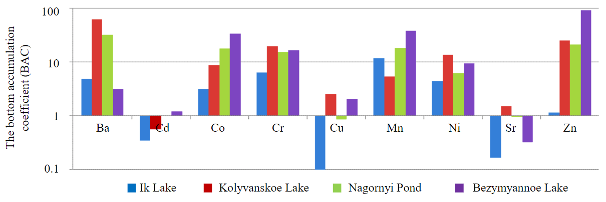
Fig.3.Bottom accumulation coefficients calculated for the studied water bodies
In Nagornyi Pond and Bezymyannoe Lake high values of BAC for Cr, Zn, Co and Mn are observed, which is associated with the close location of polymetallic ore deposits. These water bodies are characterized as low polluted according to BAC. The high content of coal microparticles found in these water bodies indicates that there were fires in the surrounding landscapes. According to the data of spore-pollen analysis and analysis of non-pollen palynomorphs, the most unfavorable conditions of evolution of the lake and surrounding landscapes were obtained for Bezymyannoe Lake. The inconsistency of palynospectra of modern vegetation and high content of fungi spores in the bottom sediments of Bezymyannoe Lake testify to the anthropogenic impact on the vegetation cover. The shell amoebae found in the Nagornyi Pond indicate periodic watering of the area, which is probably related to the disturbance of the groundwater table because of anthropogenic activities in the vicinity and may lead to waterlogging over time.
Single assessments, such as BAC, are usually not sufficient to obtain a reliable overall picture of the level of contamination of bottom sediments, so the integral criterion – total pollution index (Zс) [33] is widely used. Its calculation was performed for all analyzed heavy metals for all studied water bodies, except Beloe Lake, for which bottom sediments were not analyzed:
where n – the number of accounted metals; K – the contrast coefficient.
Contrast coefficients for each metal were calculated as the ratio of its concentration in the study area to the corresponding background concentration, and the MAC (APC) values for soils were taken as background concentrations (see Table 2).
The total pollution index (Zс) by gross and mobile forms of metals calculated for bottom sediments of the studied water bodies are presented graphically in Fig.4.
Based on the methodology of Yu.E.Saet, the calculated values of total pollution indexes for mobile and gross forms of metals (Fig.4) and the ratio between them allow us to assess the pollution level of Nagornyi pond and Bezymyannoe Lake as high, Kolyvanskoe Lake – as medium, Ik Lake – as low. In addition, for the Nagornyш Pond and Bezymyannoe Lake total indicators of pollution by mobile forms of metals significantly exceeding the total indicators of pollution by gross forms, which characterizes the bottom sediments of the considered water bodies as a dangerous source of secondary pollution, and determines their high danger for hydrobionts.
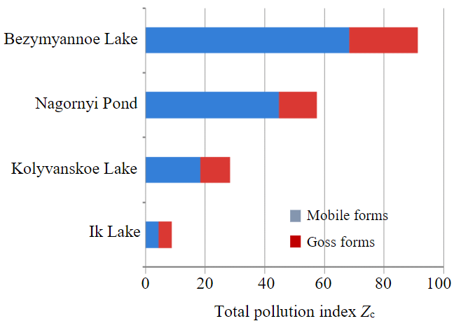
Рис.4. Values of the total pollution index of bottom sediments of the studied water bodies by gross and mobile forms of metals
Conclusion
Geochemical studies of water and bottom sediments allowed assessing the ecological state of water bodies in the south-west of Siberia and Altai and in the eas-tern part of Kazakhstan. Thus, Nagornyi Pond and Bezymyannoe Lake were classified as water bodies with a high level of pollution caused by prolonged anthropogenic load from underground and open-pit mines located near active or worked-out underground and open-pit mines. The data of spore-pollen analysis and analysis of non-pollen palynomorphs confirm these results. Maximum values of ruderal grasses, fungal spores and coal microparticles were noted here. Kolyvanskoe Lake and Beloe Lake are characterized by the average level of pollution. It is also important to note that in the bottom sediments of Kolyvanskoe Lake high values of indicators of total pollution by mobile forms of heavy metals relative to their gross forms were recorded, which shows a low self-purifying capacity of the water body. Taking into account the rapid growth rate of recreational load, one can predict a sharp deterioration of the ecological state of the lake. Ik Lake is characterized by the most favorable ecological condition from of all studied lakes. According to the results of palynological analysis, the highest percentage of Pediastrum algae was noted here, which allows us to conclude that the lake has a high self-purifying capacity and low anthropogenic load.
The conducted studies indicate the possibility of using a new method of express assessment of the ecological state of aquatic ecosystems by studying lakes with the help of spore-pollen and geochemical analyses of the upper layer of lake bottom sediments. If geochemical indicators of water provide information about the ecological state of water bodies themselves, the results of spore-pollen analysis and analysis of non-pollen palynomorphs of lake bottom sediments, as well as geochemical analysis of lake sediments show the effect of anthropogenic impact in a wider aspect (lake and its catchment). The combined use of the methods allows to assess not only lake water quality, but also lake ecosystems in general, as well as to make retrospective analysis of the sources of impact. This method does not imply an in-depth investigation of the causes of pollution and forecasting of possible consequences, but it can be used to obtain a quick assessment for further large-scale studies.
References
- Tusupbekov J.A., Ryapolova N.L. Assessment of the environmental sustainability of surface waters in Western Siberia. Procee-dings of Voronezh State University. Series: Geography. Geoecology. 2019. N 3, p. 55-60 (in Russian). DOI: 10.17308/geo.2019.3/2324
- Sabatier P., Moernaut J., Bertrand S. et al. A Review of Event Deposits in Lake Sediments. Quaternary. 2022. Vol. 5. Iss. 3. N 34. DOI: 10.3390/quat5030034
- Volkodaeva M.V., Kiselev A.V. On development of System for Environmental Monitoring of Atmospheric Air Quality. Journal of Mining Institute. 2017. Vol. 227, p. 589-596. DOI: 10.25515/PMI.2017.5.589
- Dauvalter V.A., Denisov D.B., Slukovskii Z.I., Dinu M.I. Biogeochemical Features of Functioning of Small Arctic Lakes of the Khibiny Mountains under Climatic and Environmental Changes. Geochemistry International. 2022. Vol. 60. N 6, p. 560-574. DOI: 10.1134/S0016702922050044
- Slukovskii Z.I., Guzeva A.V., Dauvalter V.A. Rare earth elements in surface lake sediments of Russian arctic: Natural and potential anthropogenic impact to their accumulation. Applied Geochemistry. 2022. Vol. 142. N 105325. DOI: 10.1016/j.apgeochem.2022.105325
- Sapelko T.V. Paleolimnological research: new possibilities and possible mistakes. Paleolimnology of Northern Eurasia: experience, methodology, current status and young scientists school in microscopy skills in paleolimnology, 1-4 October 2018, Kazan, Russia. Proceedings of the 3rd International Conference, 2018, p. 104-105.
- Lukanina E., Blyakharchuk T. A comparison of spore-pollen spectra of forest, forest-steppe and steppe of Western Siberia. 12th International Meeting Pollen Monitoring Programme. Abstract book, 20-23 August 2019, Riga, Latvia, 2019, p. 21-24.
- Popolzin А.G. Lakes of the south of the Ob-Irtysh basin. Novosibirsk: Zapadno-Sibirskoe knizhnoe izd-vo, 1967, p. 350 (in Russian).
- Strakhovenko V.D., Kabannik V.G., Malikova I.N. Geochemical features of the ecosystem of Lake Kolyvan (Altai territory) and related technogenic impact. Lithology and Mineral Resources. 2014. Vol. 49. N 3, p. 220-234. DOI: 10.1134/S0024490214030055
- Poznyakov А.А. On the history of Kolyvan Lake. Bulletin of the Altay Branch of the Russian Geographical Society. 2015. Vol. 38. N 3, p. 93-98 (in Russian).
- Korotaeva A.E., Pashkevich M.A. Spectrum survey data application in ecological monitoring of aquatic vegetation. Mining Informational and Analytical Bulletin. 2021. N 5-2, p. 231-244 (in Russian). DOI: 10.25018/0236_1493_2021_52_0_231
- Iakovleva E., Belova M., Popov A. Mining and Environmental Monitoring at Open-Pit Mineral Deposits. Journal of Ecological Engineering. 2019. Vol. 20. Iss. 5, p. 172-178. DOI: 10.12911/22998993/105438
- Ponomarenko M.R., Kutepov Y.I. Complexity Assessment to Substantiate Deformation Monitoring at Open Pit Mines. Journal of Mining Science. 2021. Vol. 57. Iss. 6, p. 986-994. DOI: 10.1134/S1062739121060119
- Yagnachkova N.I. Natural monuments of Mountain Kolyvan. The Altai Territory is proud of this: based on materials from a creative competition. Barnaul: Azbuka, 2008, p. 24-26 (in Russian).
- Kuzmenkin D.V., Ivanova E.S. Quantitative characteristic of macrozoobenthos in littoral zone of Kolyvanskoe and Beloe lakes (North-Western Altai) according to research in 2019. Proceedings of the Tigirek State Natural Reserve. 2020. Iss. 12, p. 100-104 (in Russian). DOI: 10.53005/20767390_2020_12_100
- Suiekpayev Y.S., Sapargaliyev Y.M., Dolgopolova A.V. et al. Mineralogy, geochemistry and U-Pb zircon age of the Karaotkel Ti-Zr placer deposit, Eastern Kazakhstan and its genetic link to the Karaotkel-Preobrazhenka intrusion. Ore Geology Reviews. 2021. Vol. 131. N 104015. DOI: 10.1016/j.oregeorev.2021.104015
- Nigmatova S.A., Bayshashov B.U., Pirogova T.E. et al. Geology, stratigraphy and palaeontology of the Eocene Shynzhyly locality (Eastern Kazakhstan) and comparison with the continental Eocene of Italy. Gortania. Geologia, Paleontologia, Paletnologia. 2020. Vol. 42, p. 37-53.
- Pashkevich M.A., Danilov A.S., Matveeva V.A. Remote sensing of chemical anomalies in the atmosphere in influence zone of Korkino open pit coal mine. Eurasian Mining. 2021. N 1, p. 79-83. DOI: 10.17580/em.2021.01.16
- Shelekhova T.S., Lavrova N.B. Paleogeographic reconstructions of the Northwest Karelia region evolution in the holocene based on the study of small lake sediments. Trudy Karelskogo nauchnogo tsentra Rossiiskoi akademii nauk. 2020. N 9, p. 101-122 (in Russian). DOI: 10.17076/lim1268
- Sapelko T.V., Tsyganov A.N., Mazei Yu.A. et al. New approaches to complex paleolimnological studies of the Holocene history of lakes. Trudy Paleontologicheskogo obshchestva. 2018. Vol. 1, p. 118-124 (in Russian).
- Blyakharchuk T.A., Mitrofanova E.Y., Eirikh A.N. Integrated palaeoecological investigation of bottom sediments from lake Manzherokskoye in the piedmont Altai region. Trudy Karelskogo nauchnogo tsentra Rossiiskoi akademii nauk. 2015. N 9, p. 81-99 (in Russian). DOI: 10.17076/lim166
- Sarapulova G.I. Geochemical approach in assessing the technogenic impact on soils. Journal of Mining Institute. 2020. Vol. 243, p. 388-392. DOI: 10.31897/PMI.2020.3.388
- Salamov A.M., Mammadov V.A., Khalilova H.Kh. Study of the Anthropogenic Impact on the Change of Geoecological Conditions of the Khojahasan Lake, Azerbaijan. Journal of Mining Institute. 2019. Vol. 239, p. 603-610. DOI: 10.31897/PMI.2019.5.603
- Borodina E.V., Borodina U.O. Factors affecting chemical composition of lake water of specially protected areas in Altai mountains, Russia, based on Multa river basin study. Vodnye resursy. 2019. Vol. 46. N 4, p. 405-416 (in Russian). DOI: 10.31857/S0321-0596464405-416
- Kremleva T.A., Moiseyenko T.I., Khoroshavin V.Y., Shavnin A.A. Geochemical features of natural waters of West Siberia: microelement composition. Tyumen State University Herald. 2012. N 12, p. 71-80.
- Valiev V.S., Shamaev D.E., Khasanov R.R., Malanin V.V. Heavy metals mobility in sediments and peculiarities of variability interpretation. Russian Journal of Applied Ecology. 2022. N 2, p. 61-67 (in Russian). DOI: 10.24852/2411-7374.2022.2.61.67
- Mazur V.V., Dorovskikh G.N. Accumulation of metals in the bottom sadiments. Syktyvkar University Bulletin. Series 2. Biology, geology, chemistry, ecology. 2013. N 3, p. 159-177 (in Russian).
- Legostaeva Y.B., Gololobova A.G. Bottom Sediments as an Indicator of the Geoecological State of Natural Water Currents. Ecology and Industry of Russia. 2022. Vol. 26. N 11, p. 66-71 (in Russian). DOI: 10.18412/1816-0395-2022-11-66-71
- Pashkevich M.A., Bech J., Matveeva V.A., Alekseenko A.V. Biogeochemical assessment of soils and plants in industrial, residential and recreational areas of Saint Petersburg. Journal of Mining Institute. 2020. Vol. 241, p. 125-130. DOI: 10.31897/PMI.2020.1.125
- Kharko P.A., Matveeva V.A. Bottom sediments in a river under acid and alkaline wastewater discharge. Ecological Engineering and Environmental Technology. 2021. Vol. 22. Iss. 3, p. 35-41. DOI: 10.12912/27197050/134870
- Piirainen V.Y., Mikhaylov A.V., Barinkova A.A. The concept of modern ecosystem for the Ural Aluminium Smelter. Tsvetnye metally. 2022. N 7, p. 39-45 (in Russian). DOI: 10.17580/tsm.2022.07.04
- Pashkevich M.A., Bykova M.V. Methodology for thermal desorption treatment of local soil pollution by oil products at the facilities of the mineral resource industry. Journal of Mining Institute. 2022. Vol. 253, p. 49-60. DOI: 10.31897/PMI.2022.6
- Valiev V.S., Ivanov D.V., Shagidullin R.R. A method for integrated assessment of sediment pollution. Trudy Karelskogo nauchnogo tsentra Rossiiskoi akademii nauk. 2019. N 9, p. 51-59 (in Russian). DOI: 10.17076/lim1122