Results and prospects of geological mapping of the Arctic shelf of Russia
- Ph.D. Deputy General Director Russian Research Institute for Geology and Mineral Resources of the World Ocean named after I.S.Gramberg ▪ Orcid

Abstract
The results of compiling the sets of the State Geological Map at a scale of 1:1,000,000 for the Arctic continental shelf of Russia are analyzed. Results are summed up, and the main problems of geological mapping are outlined. The results of geological and geophysical studies of the Arctic Ocean are of great importance for deciphering the geological evolution. The Arctic shelf is the widest shelf in the world, while the spreading ocean basin is one of the narrowest and is characterized by anomalous structural features. The main problems of geological mapping include identification the sedimentary cover/folded basement boundary, interpretation the geodynamic evolution of the shelf and adjacent ocean, determining the rates of sedimentation and stratigraphic subdivision of the sedimentary cover due to a small number of key boreholes. It is promising to further study problem areas with unclear features of geological structure as well as small-scale mapping in areas of industrial development on the Arctic continental shelf.
None
Introduction
Geological mapping is so far the main method for understanding the geological structure of the area. Geological study of the areas closed by a modern sedimentary cover and shelf zones is associated with specific methodology of the field work and data interpretation. For such zones, remote sensing methods are of great importance. Their use, on the one hand, opens up new possibilities; however, they can give only approximate information about the geological structure. For the continental shelf, geophysical surveys of potential fields and seismic profiling are commonly used which should be verified by boreholes. The Arctic shelf of Russia is so far underexplored by drilling methods, and the study of its eastern sector applying seismic methods started quite recently.
With appearance of the new geophysical data as well as development of new methods of dating and studying the material composition of rocks and minerals, ideas about the formation time of tectonic structures and geodynamics of the Arctic also changed. Climate warming in recent decades allowed organizing geological and geophysical expeditions in high-latitude areas of the Arctic previously inaccessible for research due to heavy pack ice.
The programme on making of the sheets of the State Geological Map at a scale of 1:1,000,000 (Gosgeolkarta-1000) for the territory of Russia will be completed in 2025. Over the past 30 years, sheets have been were compiled for almost all the Arctic shelf basins of Russia: the Barents, Kara, Laptev, East Siberian, and Chukchi.
The works, the results of which are being discussed in the article, were carried out in compliance with the current instructive and methodological documents regulating the geological survey and compilation of the state geological maps at a scale of 1:1,000,000 [1]. The geological and geophysical materials obtained on the sheets, the conclusions, and recommendations of the authors of the maps were summarized, analyzed, and formed the basis of this article.
Discussion
Main results
In addition to the sheetwise state geological mapping of the Arctic shelf, thematic generalizations of the obtained data were made, both cartographic and scientific, published as sketch maps, atlases, collections of articles and monographs [2, 3]. In particular, the Atlas of Geological Maps of the Circumpolar Arctic was prepared [4, 5] comprising geological, tectonic, and geophysical maps. The Commission for the Geological Map of the World (CGMW) and its subcommittees acted as the coordinator of mapping. Through the joint efforts of geologists and geophysi-cists from Russia, Canada, Norway, Denmark, and the United States the legends were drawn up, on the basis of which the Atlas maps were later compiled.
Features of geological structure and tectonic evolution of the Arctic shelf are determined by the geotectonic position of the Russian sector of the shelf in the Arctic. The Eurasian continent in the Arctic part is represented by a passive continental margin conjugated with the Arctic Ocean basin. The Arctic Ocean is the smallest of the ocean basins and is surrounded by the most extensive shelves. These distinctive features, together with the circumpolar location of the ocean, can account for the unique geology of its structures.
The entire course of the Phanerozoic evolution of the Arctic region determined its current structure, in particular, the fundamental difference in the structure of the western and eastern sectors of the Russian Arctic. The main process superimposed on all the earlier formed structures is that of ocean formation. Rifting and subsequent spreading of the ocean floor in the Eurasian Basin [6], like many processes developing in the Arctic, were characterized by specific features. By the beginning of the Quaternary, the main morphostructures of the ocean, shelf and continental landscapes had been formed. The influence of oceanic tectonic and magmatic processes on the shelf and land manifested with various intensity in different areas.
The main factor that determined the diversity of modern landscapes and climate of the Arctic shelf is the tectonic one; the leading neotectonic process is ocean formation. Differentiated tectonic movements, both vertical and horizontal, led to formation of the outlines of oceanic basins and ridges and uplifts separating them, which also influenced the continental margin. Destruction of the continental crust in the outer part of the continental shelf showed up in formation of graben-like and rif-
tinduced troughs [7].
History of the Arctic as an Arctic oceanic basin began with the opening of the straits connecting the once isolated Arctic basin with generally desalinated water [8, 9]. Opening of the Fram Strait in the Early Miocene (17.5 Ma ago) led to intrusion of the Atlantic water; around this time, active formation of the Arctic fauna began. Many researchers associate the start of pack ice development in the Arctic basin with this time.
The history of the Bering Strait opening is reconstructed from migration of marine fauna from the Pacific to the Atlantic through the Arctic basin. Some hydrobiologists recognized a possible pe-netration of mollusks and diatoms along this route in the Neogene [10]. Another evidence of existence and closing of the Bering Strait are the data on dispersal of mammals and prehistoric humans in this region [11].
The Late Cenozoic troughs on the East Arctic shelf of Russia are compensated by correlated sediments and are not visible in modern seabed morphology. Vertical neotectonic movements on the insular and continental land adjacent to the East Arctic shelf are not well-defined. The West Arctic shelf of Russia was affected by neotectonics in Neogene-Quaternary time including the Late Pleistocene-Holocene [12, 13]. At the last evolution stages of the Arctic shelf of Russia, the main difference between its western and eastern sectors took shape; it consists in relief dissection of the Barents and Kara sea floors and levelled floors of the shallow Laptev, East Siberian, and Chukchi seas.
The ensemble of tectonic structures of the Russian Arctic formed by the Quaternary period was modelled during the Eopleistocene-Holocene by the exogenous processes, in which the leading role was played by transgressions and regressions of the Arctic basin, development and degradation of terrestrial and underground glaciation and other processes shaping modern polar landscapes.
Problems of mapping the Arctic shelf and adjacent oceanic structures
In addition to the general regional features of geological structure of the Arctic shelf of Russia identified in the course of mapping, there are certain debatable issues that have yet to be resolved.
Folded belts and areas with different consolidation ages occur within the Arctic shelf of Russia; their outlines drawn by the international team of researchers with minor amendments made by the author are schematically shown in Fig.1.
With development of seismic methods for studying deep structure, the geologists receive new qualitative geophysical data on the structure of the upper part of the Earth's crust. Previously, on seismic lines, the folded basement looked like an area with a disordered record in which no structures could be distinguished. Therefore, the so-called acoustic basement and the sedimentary cover overlying it were mapped. This was the main task of the geological survey of the shelf basins in the Arctic. The structure of the Earth's crust below the acoustic basement surface was reconstructed using seismic density modelling with distinguishing of crustal layers and blocks, deep faults, seismic wave propagation velocities, etc.
New seismic MCS data obtained using more powerful sources with significant depth and high resolution allow observing the structures below the acoustic (folded) basement surface. Sometimes, in the field of reflected waves, in addition to the sedimentary cover strata, the structure of the upper crust is visible – the internal structure of the folded basement, the boundary of the crystalline basement, and, in places, the Moho surface [14]. These unique materials often confirm the earlier notions about the Earth's crust structure under sedimentary basins based on old geophysical data; sometimes, it is necessary to make adjustments to the models of structure of certain basins.
Geological sections constructed from the new seismic lines make it possible to reassess the oil and gas potential of the Arctic shelf basins and the continental framing. More obvious information about the distribution of thicknesses of sedimentary complexes and their presumed lithological composition, the distribution of tectonic faults, and other structural features have led to the new expert assessments of oil and gas potential of the Arctic shelf. At the same time, it is necessary to point out the risk of a direct interpretation of the MCS seismic data without taking into account the material composition of the complexes exposed on the surface or penetrated by boreholes on the nearby insular and continental land. Thus, many authors also estimate rock strata of the folded basement which are clearly seen on the new seismic records as a slightly layered medium with a potential for oil and gas presence.
In Western Taimyr, the South Taimyr prospective oil and gas area was identified [15], where the following complexes are assigned to the metasedimentary cover: Vendian-Paleozoic, Upper Permian-Lower Triassic, and Meso-Cenozoic. In the field of reflected waves on modern high-quality MCS seismic lines, reflectors and their series are, in fact, traced forming a folded structure [16]. Apparently, these are former sedimentary rocks (mudstones, sandstones, siltstones) that have been folded, disturbed by faults, and penetrated by dikes and sills of mafic rocks. The author has observed the exposures of these rocks (Fig.2) crushed into folds, cleaved, broken by faults, fractures carrying hydrothermal mineralization. If these rocks could once be oil-source beds and reservoir cap rocks, then in their present form they are a permeable medium. The subsurface of Western Taimyr in the occurrence areas of the pre-Mesozoic rocks is tectonically open, and one should hardly expect any special prospects of oil and gas presence there. It would be more correct to define such areas as unpromising or having a low potential [17].
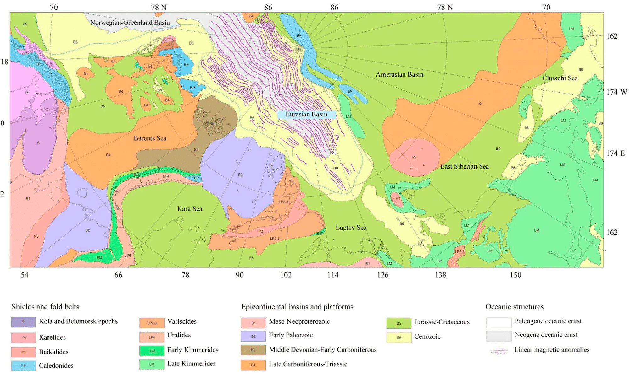
Fig.1. Tectonic sketch map of the Arctic region, after [4], with amendments
There is a similar uncertainty in the structural definition of the Paleozoic rocks on the Mendeleev Rise adjoining the East Arctic shelf of Russia. Apparently, the Mendeleev Rise at the pre-oceanic stage was an area with a platform structure. The age of the folded basement of the ancient platform was, possibly, Karelian or Baikalian, or perhaps even younger, Caledonian [18]. Samples of Paleozoic rocks were taken during the “Arctic-2012” and “Arctic-2014” expeditions. Organic remains collected from the Mendeleev Rise confirm the occurrence of the Upper Silurian (?)-Permian carbonate deposits in the platform cover. Both shallow, and deep-water facies are reconstructed from the lithological composition, structural and textural features, and the organic remains [19].
Platform cover of the Mendeleev Rise underwent destruction in several stages. It is difficult to estimate the nature of deformations if these formations occur in the acoustic basement, and igneous rocks are mainly exposed on seabed projections. Relatively low seismic velocities, minor alteration of Paleozoic rocks, the absence of metamorphism, evidence of cataclasis, cleavage and other signs of complete folding lead to the conclusion of a minor degree of the folding processes affecting the platform cover.
Anyhow, rocks of the platform cover are not seen in the field of reflected waves on the MCS lines as layered formations; thus, when deciphering the tectonic structure and assessing the prospects for oil and gas potential, one has to point to a disturbed condition of the pre-Cretaceous complexes. An extensive development of magmatism showing up in regional occurrence of volcanic, sedimentary volcanogenic and intrusive complexes of predominantly mafic composition on the Mendeleev Rise also had a significant impact [21]. The outflowing basaltic covers partially concealed the basement and cover of the ancient platform broken by block movements. On the MCS lines, the basaltic covers acted as a screen not transmitting, scattering, or partially transmitting seismic waves below the acoustic basement surface. As a result, in the seismic record, among the chaotic pattern of the acoustic basement, there are local ordered reflectors pointing to lamination similar to depositional layering.
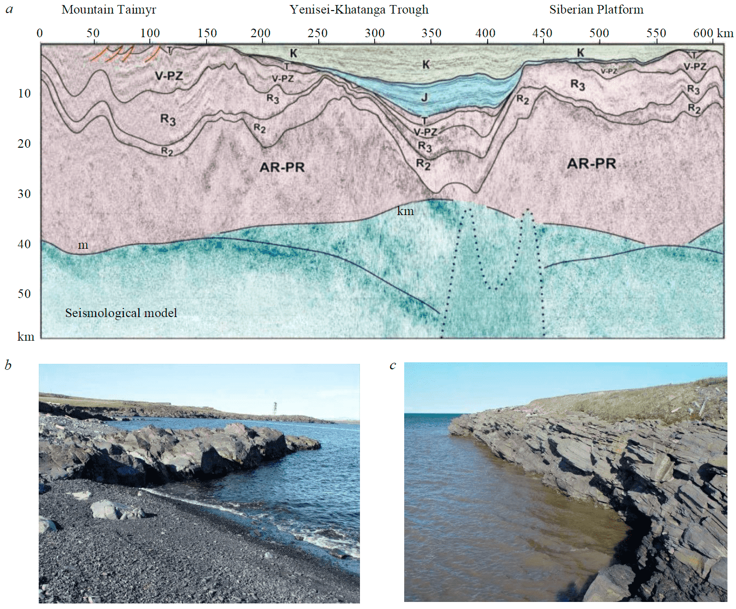
Fig.2. An example of a seismic record (a) within the Yenisei-Khatanga Trough in the centre of the line, Mountain Taimyr – in the left part of the line after [20], exposure of rocks of the Efremovskaya Formation (Early Permian) near of Dikson (b), outcrop of rocks of the Ubojninskaya Formation (Early Permian) near Cape Makarevich, Western Taimyr (c)
Most of the faults on the Mendeleev Rise are steeply dipping and well-defined in the seismic record and often in bathymetry as bottom topography ledges. Possibly, there were multistage tectonic processes in this region. Fault amplitudes reach 300-500 m. In the ridge part of the Mendeleev Rise these faults are assumed to have a sinistral slip component [22, 23].
The oceanic structures adjoining the Eurasian continental margin are characterized by anomalous structural features. This applies, in particular, to the Eurasian Basin where the Cenozoic linear magnetic anomalies are common in the Amundsen and Nansen basins, while the age of the lower horizons of the sedimentary cover over most of the area is estimated as Lower-Upper Cretaceous, or even Jurassic (near East Taimyr) [24]. Within the perioceanic troughs, even older complexes are sometimes traced [25, 26], to the Paleozoic ones [27].
Fig.2. An example of a seismic record (a) within the Yenisei-Khatanga Trough in the centre of the line, Mountain Taimyr – in the left part of the line after [20], exposure of rocks of the Efremovskaya Formation (Early Permian) near of Dikson (b), outcrop of rocks of the Ubojninskaya Formation (Early Permian) near Cape Makarevich, Western Taimyr (c)
The Gakkel mid-oceanic ridge in the Eurasian Basin also has a complex evolution history. Unlike other ridges of the World Ocean, it does not contain transform faults. Near the centriclinal closure of the Eurasian Basin, the ridge ends in a deep volcanotectonic basin over 5,000 m deep [28]. Further, within the continental margin, a seismically active zone is traced manifesting itself as a graben-like structure of the continental slope and foot. The rift zone of the ridge is characterized by the occurrence of blocks with an abnormally thick sedimentary cover on the oceanic basement [29]. This leads to the conclusion that the extension is pulsational; spreading is not continuous throughout the entire rift zone but is localized in certain areas.
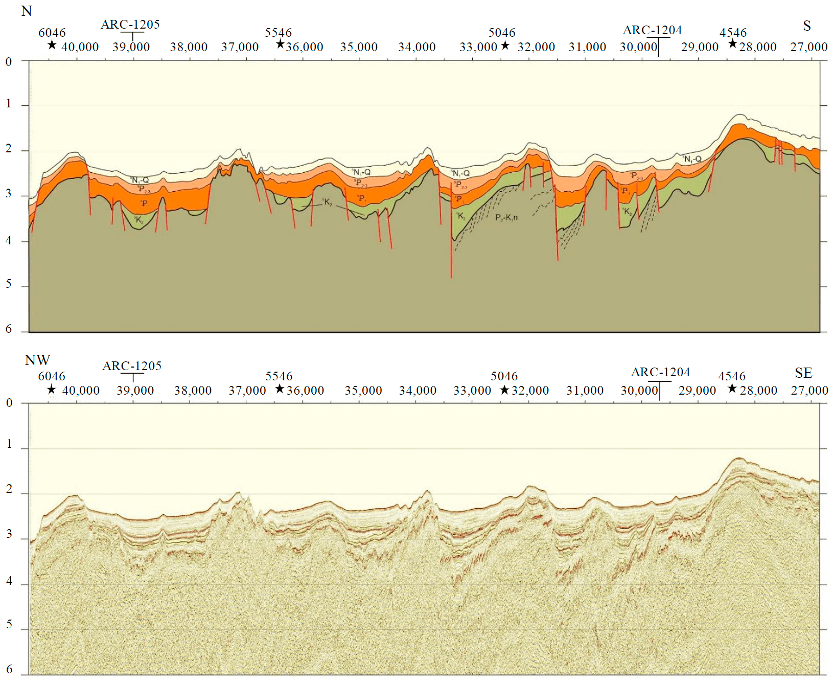
Fig.3. A fragment of the seismic MCS line crossing the ridge zone of the Mendeleev Rise. Dotted reflectors are observed within the folded basement
There is still no consistent stratigraphic model for the sedimentary cover structure on the Arctic shelf and adjacent oceanic structures. This is mainly due to the absence of boreholes on the Eastern Arctic shelf of Russia as well as in the deep-sea part of the Arctic. There are different opinions on the age of the sedimentary cover in the sedimentation basins of the Laptev, East Siberian, and Chukchi seas. There are different opinions on the structure of the uppermost part of sediments both on the shelf, and in the oceanic area. Hence, different estimates of sedimentation rates within the Arctic in general. In the deep-sea part, on uplifts and ridges of the Arctic Ocean, sedimentation rates are ranging from millimeters [30] to several centimeters per thousand years [31]. To solve this problem, not only micropaleontological, paleomagnetic, radiocarbon methods of stratigraphic dating of sediments are required, but also uranium-thorium and chemostratigraphic ones [32, 33], which point to low sedimentation rates in the deep-sea part of the Arctic.
Certain difficulties sometimes arise with the interpretation of the results of seismoacoustic studies, particularly in shallow water zones, areas of permafrost development and zones of gaseous fluids seepage to the seabed surface [34]. Such areas on which it is difficult to obtain intelligible geological and geophysical data should be studied on an integrated basis using different types of seismic and seismoacoustic methods.
When different geophysical data are incomparable, a zonal-block model of the Earth's crust and generalized models of geodynamic environment are used to create a model of the geological structure of shelf basins of the Arctic [35].
The outlook
In 2025, work under the programme of the state geological mapping of the territory of the Russian Federation and its continental shelf at a scale of 1: 1,000,000 will be completed. Further prospects for geological mapping of the Arctic apply, first of all, to the underexplored areas of the Arctic shelf as well as the Eurasian continental margin in the Severnaya Zemlya and Franz Josef Land archipelagos. It is necessary to study the Eastern Arctic shelf in more detail using geophysical me-thods as well as bottom sampling and drilling.
In addition, good prospects are offered by the compilation of geological maps at a scale of 1:200,000 in areas of intense industrial development (Baydaratskaya, Tazovskaya and Ob’ bays) and coastal waters near large cities.
It is necessary to update the methods of geological surveying of the shelf. Designing of regular grids of geological and geophysical observations with the survey density required by the scale is already outdated. It is more reasonable to run the geophysical lines and the lines of geological sampling of the sea floor with the necessary observation density in key areas. To increase the information content, it is reasonable to introduce single line observations with a variation of different geophysical modifications (deep or high-resolution seismic survey, gravity magnetometry, geoelectric prospec-ting, seismoacoustics, geoacoustics, etc.). The integration of methods improves the quality of the final product. Perhaps, it is necessary to stop using checkrow sampling of the area with massive bottom grabs and overall seabed corers. The use of light-weight samplers on a sparse grid and shallow drilling of two or three wells in the area is more informative. The experience of shallow drilling was obtained by VNIIOkeangeologiya on the Chukchi shelf, where boreholes were drilled from a sea tug by a multi-trip drilling rig designed at Donetsk University [36]. It is also necessary to introduce into the practice of the offshore geological surveying new laboratory research methods available to surveyors.
Conclusions
Over the past decade, geological institutions obtained new results in the geological mapping of the Arctic shelf and adjacent deep-sea areas of the Arctic Ocean. The compiled sheets of the State Geological Map of the Russian Federation at a scale of 1:1,000,000 are comprised into the sketch geological map of Russia and adjacent water areas supplementing it with new data. The results of compilation of the sets of maps of Gosgeolkarta-1000/3 are published in the articles and monographs. The prospects for geological surveys in the Arctic are outlined, associated with the completion of mapping at a scale of 1: 1,000,000 and local geological surveys at a scale of 1:200,000 in coastal water areas near large cities and in zones of intense industrial development.
References
- Guidelines for the compilation and preparation for publication of the sheets of the State Geological Map of the Russian Federation at a scale of 1:1,000,000 (third generation). Version 1.4. St. Petersburg: Kartograficheskaya fabrika VSEGEI, 2019, p. 169.
- Piskarev A.L., Poselov V.A., Avetisov G.P. et al. Arctic Basin (geology and morphology). Sain Petersburg: VNIIOkeangeologiya, 2017, p. 291 (in Russian).
- Avetisov G.P., Butsenko V.V., Chernykh A.A. et. al. The Current State of the Arctic Basin Study. Geologic Structures of the Arctic Basin, Cham, Switzerland: Springer International Publishing AG, 2019, p. 1-69. DOI: 10.1007/978-3-319-77742-9_1
- Petrov O., Morozov A., Shokalsky S. Crustal structure and tectonic model of the Arctic region. Earth-Science Reviews. 2016. Vol. 154, p. 29-71. DOI: 10.1016/j.earscirev.2015.11.013
- Petrov O.V., Smelror M. Uniting the Arctic frontiers – International cooperation on circum-Arctic geological and geophysical maps. Polar Record. 2015. Vol. 51, p. 530-535. DOI: 10.1017/S0032247414000667
- Nikishin A.M., Gaina C., Petrov E.I. et. al. Basin and Gakkel Ridge, Arctic Ocean: Crustal asymmetry, ultra-slow spreading and continental rifting revealed by new seismic data. Tectonophysics. 2018. Vol. 746, p. 64-82. DOI: 10.1016/j.tecto.2017.09.006
- Kazanin G.S., Barabanova Yu.B., Kirillova-Pokrovskaya T.A. et al. Continental margin of the East Siberian Sea: geological structure and hydrocarbon potential. Prospect and protection of mineral resources. 2017. N 10, p. 51-55 (in Russian).
- Brinkhuis H., Schouten S., Collinson M.E. et al. Episodic fresh surface waters in the Eocene Arctic. Nature. 2006. Vol. 441 (7093), p. 606-609. DOI: 10.1038/nature04692
- Moran K., Backman J., Brinkhuis H. et. al. The Cenozoic palaeoenvironment of the Arctic Ocean. Nature. 2006. Vol. 441 (7093), p. 601-606. DOI: 10.1038/nature04800
- Gladenkov A.Yu., Gladenkov Yu.B. Onset of connections between the pacific and arctic oceans through the bering strait in the Neogene. Stratigraphy and Geological Correlation. 2004. Т. 12. N 2, p. 175-187 (in Russian).
- Elias S.A., Short S.K., Nelson C.H., Birks H.H. Life and times of the Bering Land Bridge. Nature. 1996. Vol. 382, p. 60-63. DOI: 10.1038/382060a0
- Krapivner R.B. Rapid sagging of the Barents Shelf over the last 15-16 Ka. Geotectonics. 2006. Vol. 40. N 3, p. 197-207. DOI: 10.1134/S0016852106030046
- Krapivner R.B. Indications Of Neotectonic Activity At The Barents Sea Shelf. Geotectonics. 2007. Vol. 41. N 2, p. 149-162. DOI: 10.1134/S0016852107020057
- Telegin A.N. Possibilities of Seismic Exploration for Crystalline Basement Study. Journal of Mining Institute. 2017. Vol. 223, p. 30-36. DOI: 10.18454/PMI.2017.1.30
- Baldin V.A., Munasypov N.Z., Sharafutdinov T.R. More precise definition of West Siberian Basin borders on Taimyr Pe-ninsula. Geologiya nefti i gaza. 2018. N 3, p. 59-74 (in Russian). DOI: 10.31087/0016-7894-2018-3-59-74
- Munasypov N.Z., Baldin V.A. Prospects for oil-and-gas potential of the Neoproterozoic-Paleozoic deposits of the South Taimyr structural tectonic zone of Mountain Taimyr: Proceedings of the IV International Geological and Geophysical Conference and Exhibition “GeoEurasia-2021. Geological Exploration in Modern Realities”. Tver: “PoliPRESS”, 2021, p. 272-277.
- Afanasenkov A.P., Obukhov A.N., Chikishev A.A. et al. Tectonic setting of the northern surroundings of the Siberian platform based on the integrated study of geological and geophysical data. Oil and Gas Geology. 2018. N 1, p. 7-27 (in Russian).
- Kabankov V.Y., Andreeva I.A., Petrova V.I., Ivanov V.N. the geotectonic nature of the Central Arctic Morphostructures and geological implications of bottom sediments for its interpretation. Geotectonics. 2004. Vol. 38. N 6, p. 430-442 (in Russian).
- Skolotnev S., Aleksandrova G., Isakova T. et. al. Fossils from seabed bedrocks: implications for the nature of the acoustic basement of the Mendeleev Rise (Arctic ocean). Marine Geology. 2019. Vol. 407, p. 148-163. DOI: 10.1016/j.margeo.2018.11.002
- Kushnir D.G. Pre-Yenisei Area of Taimyr and Gydan Peninsulas – deep seated geological structure and petroleum potential prospects. Neftegazovaya Geologiya. Teoriya i Praktika. 2016. Vol. 11. N 1, p. 1-8 (in Russian). DOI: 10.17353/2070-5379/6_2016
- Verba V.V., Truhalev A.I. Plume origin of the Central Arctic uplifts evolution in the Amerasian Basin of the Arctic Ocean. Russian Journal of Earth Science. 2016. Vol. 16. ES1002 (in Russian). DOI: 10.2205/2016ES000562
- Chernykh A.A., Astafurova E.G., Glebovsky V.Y. et al. New data on tectonics of mendeleev ridge and adjacent geological structures. Doklady Earth Sciences. 2016. Vol. 470. N 2, p. 900-904 (in Russian). DOI: 10.7868/S0869565216260169
- Chernykh A., Glebovsky V., Korneva M., Zykov M. New insights into tectonics and evolution of the Amerasia basin. Journal of Geodynamics. 2018. Vol. 119, p. 167-182. DOI: 10.1016/j.jog.2018.02.010
- Alekseev M.A., Shneyder G.V. Jurassic foraminifers from boreholes in the aquatorries of the Teresa Claveness Bay on the eastern coast of the Taimyr Peninsula. Regional geology and metallogeny. 2020. N 83, p. 5-13 (in Russian).
- Daragan-Sushchova L.A., Petrov O.V., Daragan-Sushchov Yu.I. History of Formation of the Eurasian Basin, The Arctic Ocean, Based On Seismic Data. Regional geology and metallogeny. 2020. N 84, p. 25-44.
- Piskarev A.L., Avetisov G.P., Kireev A.A. et al. Structure of the Laptev Sea Shelf – Eurasian Basin Transition Zone (Arctic Ocean). Geotectonics. 2018. Vol. 52. N 6, p. 589-608 (in Russian). DOI: 10.1134/S0016853X18060061
- Gusev E.A., Krylov A.A., Urvantsev D.M. et al. Geological structure of the northern part of the Kara Shelf near the Severnaya Zemlya archipelago according to recent studies. Journal of Mining Institute. 2020. Vol. 245, p. 505-512. DOI: 10.31897/PMI.2020.5.1
- Piskarev A., Elkina D. Giant caldera in the Arctic Ocean: Evidence of the catastrophic eruptive event. Scientific. Reports. 2017. Vol. 7. N 46248. DOI: 10.1038/srep46248
- Rekant P.V., Gusev E.A. Sediments in the Gakkel Ridge Rift Zone (Arctic Ocean): structure and history. Russian Geology and Geophysics. 2016. Vol. 57. N 9, p. 1634-1640. DOI: 10.15372/GiG20160903
- Elkina D.V., Petrova V.I., Piskarev A.L., Andreeva I.A. Pliocene-Pleistocene Sedimentation. Geologic Structures of the Arctic Basin. 2019, p. 327-364. DOI: 10.1007/978-3-319-77742-9_11
- Levitan M.A. Sedimentation rates of deposits of the last five marine isotope stages in the Arctic Ocean. Okeanology. 2015. Vol. 55. N 3, p. 425-433. DOI: 10.1134/S000143701503011X
- Gusev E.A., Kuznetsov A.B., Taldenkova E.E. et. al. Rate and conditions of accumulation of the Late Cenozoic sediments on the Mendeleev Rise: Sr-iotope and δ18О-chemostratigraphy. Doklady Earth Sciences. 2017. Vol. 473. N 3, p. 336-340. DOI: 10.7868/S0869565217090171
- Dipre G.R., Polyak L., Kuznetsov A.B. et. al. Plio-Pleistocene sedimentary record from the Northwind Ridge: new insights into paleoclimatic evolution of the western Arctic Ocean for the last 5 Ma. Arktos. 2018. Vol. 4, p. 1-24. DOI: 10.1007/s41063-018-0054-y
- Gusev E.A., Gladysh V.A., Zykov E.A. et. al. Problems and Prospects of Seismoacoustic Profiling for Bottom Sediments Stratigraphy Studies, Sedimentary Cover Rocks and Submarine Permafrost Investigations on The Arctic Shelf. Conference Procee-dings, Engineering and Mining Geophysics 2021, April 2021. Vol. 2021, p. 1-7. DOI: 10.3997/2214-4609.202152120
- Egorov A. S., Vinokurov I. Yu., Telegin A. N. Scientific and methodical approaches to increase prospecting efficiency of the Russian Arctic Shelf state geological mapping. Journal of Mining Institute. 2018. Vol. 233, p. 447-458. DOI: 10.31897/PMI.2018.5.447
- Gusev E.A., Shneyder G.V., Rekant P.V., Karakozov A.A. Results of shallow drilling in Taimyr and on shelf of the East Arctic seas of Russia. Gornyy zhurnal. 2021. N 12, p. 4-9 (in Russian). DOI: 10.17580/gzh.2021.12.01