Potential technological solution for sampling the bottom sediments of the subglacial lake Vostok: relevance and formulation of investigation goals
- 1 — Ph.D. Saint Petersburg Mining University ▪ Orcid ▪ Elibrary ▪ Scopus
- 2 — Ph.D., Dr.Sci. Saint Petersburg Mining University
- 3 — Ph.D., Dr.Sci. Saint Petersburg Mining University ▪ Orcid ▪ Elibrary ▪ Scopus
- 4 — Ph.D. ▪ Orcid ▪ Elibrary ▪ Scopus ▪ ResearcherID
- 5 — Saint Petersburg Mining University
- 6 — Ph.D., Dr.Sci. VNIIOkeangeologiya

Abstract
The subglacial Lake Vostok in Antarctic is a unique natural phenomenon, its comprehensive study involves sampling of water and bottom surface rocks. For further study of the lake, it is necessary to drill a new access well and develop environmentally safe technologies for its exploration. This article discusses existing and potential technologies for sampling bottom surface rocks of subglacial lakes. All these technologies meet environmental safety requirements and are conducive for sampling. The authors have proposed an alternative technology, using a walking device, which, due to its mobility, enables selective sampling of rocks across a large area from a single access well. The principal issues, related to the implementation of the proposed technology, are investigated within this article. This report is prepared by a team of specialists with many years of experience in drilling at the Vostok Station in Antarctic and in experimental work on the design of equipment and non-standard means of mechanization for complicated mining, geological and climatic conditions.
None
Introduction
Lake Vostok in Antarctic is a unique natural phenomenon, the interest in which has not waned since the moment of its discovery [13]. Today, conducted geophysical investigations have surveyed the thickness of the glacier above of the lake, its depth, relief of its bottom and the coastline [5-7, 24].
The next step in studying the lake involves monitoring its water layer and bottom surface, taking samples of water and rocks of the bottom sedimentary layer. Initial data on the composition of the bottom sediments were obtained when the ice congelation layer was penetrated by the 5G well, where small (from 0.1 to 1 cm) mineral inclusions, captured by the glacier during its movement through the western shallow part of the lake, were found [2, 21]. The samples of lake water, which were obtained during the first penetration of the subglacial lake on February 5, 2012 [4, 25] were also analyzed [8]. In addition, the drilling of 5G well and two penetrations of the subglacial lake allowed researchers:
- to establish the basic patterns of changes in structural and physical properties along the depth of the Antarctic ice sheet;
- to draw paleoclimate series, based on the results of the study of the ice core sample;
- to create competitive technologies for drilling thick ice glaciers;
- to substantiate an ecologically safe technology for penetrating subglacial water bodies.
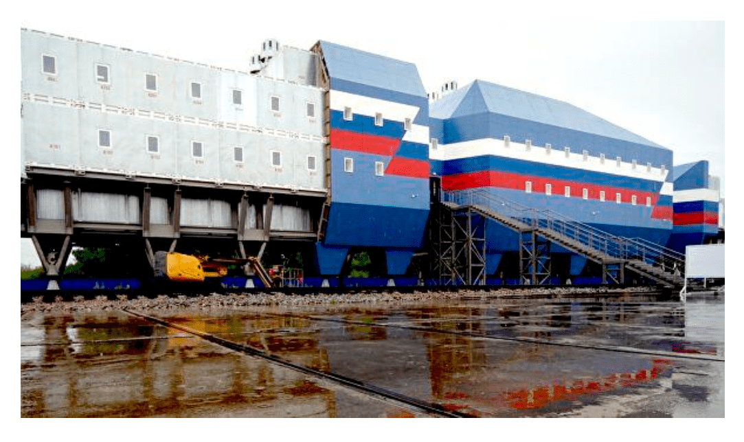
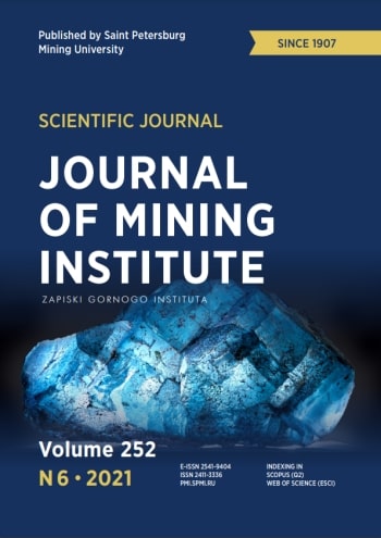
Fig.1. New living module for the “Vostok” Antarctic station [14]
However, for further investigations of the subglacial Lake Vostok, access via the existing 5G well is no longer possible resulting from the previous use of a mixture of kerosene and Freon as a drilling fluid that no longer provides the required environmental safety standards. The forthcoming construction of the new “Vostok” Station compound (Fig.1) will allow the installation of a modern drilling structure that can operate all year round. A distinctive feature of the new technologies for drilling the access well and exploring the subglacial lake should be the high level of environmental safety of the work carried out.
When creating new technologies and technical means, it is planned to widely employ extensive experience of specialists from Saint Petersburg Mining University in the field of development of equipment and technologies for deep drilling in ice [3, 23], potential of the Well Drilling department [19], developments of university geologists studying Antarctic [27, 32].
This article outlines one of the possible options for sampling the bottom surface of the subglacial Lake Vostok.
Technologies overview
Currently there are several existing technologies for sampling the bottom surface of subglacial lakes. Some were proposed by the scientists of Saint Petersburg Mining University as ideas for discussion for possible subsequent implementation specifically at Lake Vostok [23]. Other technologies have already been implemented in practice by foreign researchers, although for smaller-scale objects in comparison with Lake Vostok. Some of the most interesting projects are noted below.
Project WISSARD (Whillans Ice Stream Subglacial Access Research Drilling) – is an integrated project to study the stability of ice sheets and subglacial geobiology, carried out in West Antarctic, with financial support from the National Science Foundation (NSF), USA. Field research began in the 2010-2011 summer season and continued until the 2013-2014 season. The subjects of research were: the lower part of the Whillans Glacier on the Siple Coast, where the glacier flows from the continent to the sea shelf (Ross Sea), and the subglacial Lake Whillans [40]. Lake Whillans is located at a depth of 800 m from the surface of the glacier and has a depth of about 2 m.
The main goal of the WISSARD project was to assess the role of water under the West Antarctic glacier in interconnected glaciological, geological, microbiological, geochemical, hydrological and oceanographic systems [34]. As part of this goal, using a newly developed hot water drilling system (HWDS) [13, 16, 17], an access well was drilled in January 2013, with the help of which a thorough study of the subglacial Lake Whillans was conducted. Before running the research scientific equipment into the well, images of the profile of the well and bottom sediments of the lake were studied using a video camera in real time. The bottom sediments were sampled using three sampler models. Despite some technical difficulties encountered by the Lake Whillans researchers, they were able to successfully extract samples of subglacial bottom sediments (one sample 0.8 m long and 58 mm in diameter and samples up to 0.4 m long) [37, 39], which made it possible to carry out subsequent analysis in laboratory conditions [22, 30].
In December 2012, British scientists, led by the British Antarctic Survey (BAS), attempted to penetrate the subglacial Lake Ellsworth using specially developed hot water drilling technology. As part of the Lake Ellsworth exploration project, it was planned to establish the presence, origin, development and sustaining of life in Lake Ellsworth through sampling and further analysis [35].
Once clean access technology was developed and tested in conjunction with a geophysical study of the lake [26], drilling of the access well began in the summer season of 2012/2013. Bottom sediments sampling was planned to be carried out using an impact sampler developed by BAS and UWITEC [15]. The sampler, equipped with cameras and light sources, provides information about the sampling process in real time. Its design allows extracting samples of sedimentary rocks up to 3.8 m long [12]. During the field work, the team of British scientists faced many difficulties, which made penetration of the subglacial Lake Ellsworth, using the developed technology, impossible, and, on December 25, 2012, further attempts to drill were stopped [11]. However, although the British scientists were unsuccessful in their first attempt to reach Lake Ellsworth, the experience gained, which they deeply analyzed, will allow them to apply better solutions in their future projects.
SALSA (Subglacial Antarctic Lakes Scientific Access) is a scientific research project aimed at studying subglacial geobiology, the water layer and sedimentary organic carbon, as well as geological processes in the subglacial Lake Mercer. Lake Mercer is located at the confluence of the West Antarctic ice flows at a depth of approximately 1087 m from the ice surface; the depth of the lake is 15 m. The project is being carried out in West Antarctic with financial support from NSF. Fieldwork began in the 2016/2017 summer season and lasted until the 2019/2020 season [33].
With the hot water drilling system previously used in the WISSARD project, drilling of the access well began on 23 December 2018. On December 26, at a depth of 1087 meters, the well reached Lake Mercer. To extract samples of bottom sediments less than 1 m in length, the UWITEC gravity sampling system was used (previously used in the study of the subglacial Lake Whillans [39]), 10 samples from 0.32 to 0.49 m long were extracted from the well. A specially designed WHOI (Woods Hole Oceanographic Institute) sampler was used to retrieve a long sample of sedimentary rocks, which, due to its high weight and long sampling tube, can extract samples up to 6.1 m long. The first attempt to use the WHOI sampler was unsuccessful, sediment samples fell out of the sampler when it was raised on the surface. However, subsequently the longest (1.76 m) sedimentary rock sample ever obtained from subglacial lakes was retrieved using a WHOI gravity sampler from Lake Mercer. This project can be considered one of the most valuable in terms of the experience gained in the field of technology and technique for the study of subglacial lakes.
The main distinguishing features of the projects reviewed are the application of technology for well drilling with hot water for lake access; the use of samplers with no possibility of moving across the bottom surface of the lake.
Analysis of the proposed technology
The experience of foreign researchers will be taken into account when creating equipment and technologies for sampling the bottom surface of the subglacial Lake Vostok; not all technical solutions used in the projects under consideration may be applicable to Lake Vostok, due to its unique characteristics (depth, glacier thickness, etc.) [5].
The technology proposed by the members of the Mining University are more suitable for the characteristics of Lake Vostok, however, they also require analysis, discussion and revision. Our proposed technology for sampling the bottom surface of the subglacial Lake Vostok (Fig.2) is based on the prospect of creating a modern drilling structure in the area of the new “Vostok” Station with drilling a new well to access the lake by electromechanical and heat equipment.
Research module will be lowered to the bottom of the lake through the access well using the delivery equipment. In this technology, the walking device is considered as a research module that can be equipped with a drilling setup or another type of sampler [28, 29]. A distinctive feature of this device is the ability to move along the bottom surface of the lake, which significantly expands the area of survey work. For instance, it is possible to perform the drilling of a well grid. If necessary, any further equipment for studying the bottom surface may be mounted on the universal walking device.
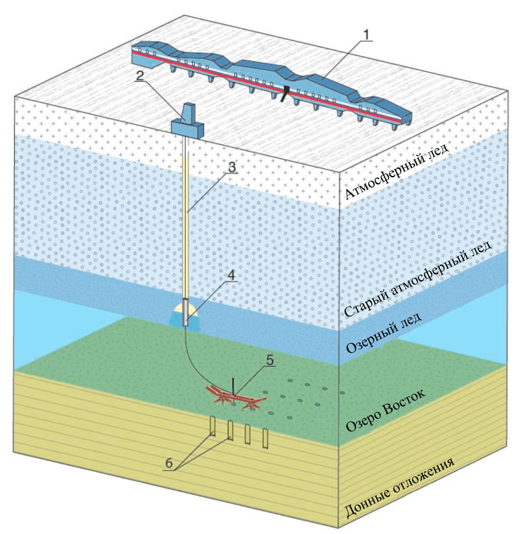
Fig.2. Technology for bottom sampling of subglacial lake Vostok 1 – new “Vostok” Station; 2 – new drilling structure; 3 – an access well filled with environmentally safe drilling fluid; 4 – delivery equipment; 5 – research module; 6 – well grid
It is planned to use low-molecular silicone oils as a drilling fluid when drilling the access well, the possible use of which was first considered in the project of drilling on dome F [18]. They have all the characteristics necessary for a drilling fluid, primarily high environmental safety properties. Nevertheless, for the final decision on their use, additional research shall be required, including test drilling [20, 31, 38].
During preparation of a new well for penetration of Lake Vostok, the previously proposed technology will be used with a rise of lake water in the extended lower part of the well [1], the main stages of which are shown in Fig.3.
Fig.3. Technology of penetrating subglacial Lake Vostok: а – completing the well drilling with an electromechanical coring equipment; b – creating a local expansion of the well diameter with a mechanical reamer; c – creating a cavity with thermal reamer; d – penetration into the subglacial lake
The first stage consists of drilling the well with an electromechanical coring equipment with a drilling stop 1-2 m above the subglacial lake (Fig.3, a), the second stage involves creation of a local expansion of the well diameter with a mechanical reamer to a height of 8-9 m from the bottomhole (Fig.3, b). The next stages involve the use of a thermal reamer, with which a cavity will be created at the third stage (Fig.3, c), and at the fourth stage the subglacial lake will be penetrated (Fig.3, d).
The delivery equipment with a research module is then descended into the well prepared for penetration. As a research module, various devices for sampling water and ground as well as surveying the bottom surface, etc. can be used. Walking device will be considered in this work.
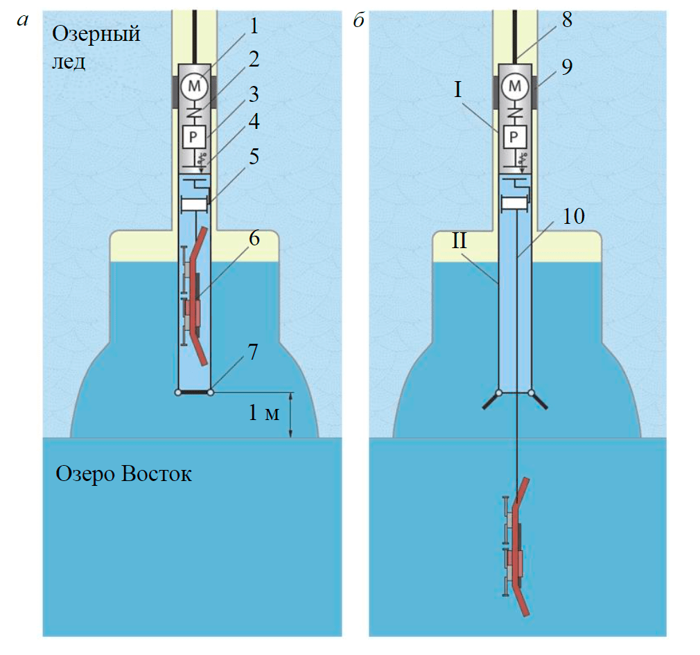
Fig.4. Delivery equipment with the walking device: a – transport position; b – start of transition to working position I – sealed winch drive unit; II – sealed unit with research equipment; 1 – drive; 2 – coupling; 3 – reducer; 4 – magnetic coupling; 5 – winch; 6 – walking device; 7 – sealed shutter; 8 – carrying cable of delivery equipment; 9 – spacer; 10 – carrying cable of walking device
The walking device is located in the delivery equipment (Fig.4), which consists of a winch drive unit and a unit with research equipment. The winch drive unit houses a drive, a coupling, a reducer and a magnetic coupling (4), which transmits the torque to the winch shaft. The unit with research equipment, to ensure the environmental safety of the work carried out, is filled with distilled water and closed with a sealed shutter (7). The delivery equipment is descended into the cavity on a carrying cable, a spacer prevents the equipment from rotating. The sealed shutter is opened and the walking device is transferred from the transport position to the working one, descending to the bottom surface on its own carrying cable, with the help of which the device will be controlled.
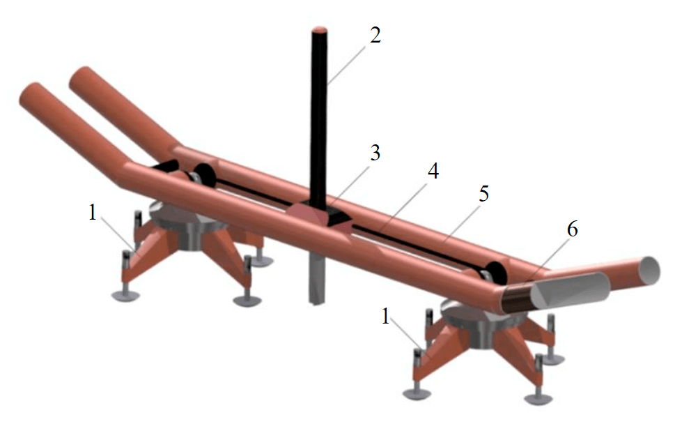
Fig.5. Conceptual design of the walking device 1 – rotating supports; 2 – drilling setup; 3 – movable carriage; 4 – guide rails; 5 – frame; 6 – counterbalance
The basic design of the walking device is shown in Fig. 5. The walking device consists of a frame, made of hollow tubes, inside which counterbalances move. Two rotating supports are pivotally attached to the frame. Counterbalances and rotating supports are necessary to ensure the process of moving the walking device along the bottom surface. Guide rails are installed on the tubes, relative to which the carriage moves with an installed drilling setup.
The movement of the walking device (Fig.6 does not show the carrying cable, connecting the device with the delivery assembly) is as follows: the device is located on the bottom surface (Fig.6, a); one of the rotating supports is raised by changing the position of the center of mass by moving the counterbalances inside the hollow tubes (Fig.6, b); the device rotates at a predetermined angle relative to the support, located on the bottom surface (Fig.6, c); the counterbalances move inside the hollow tubes, the center of mass in the device shifts and it stands again on two supports (Fig.6, d).
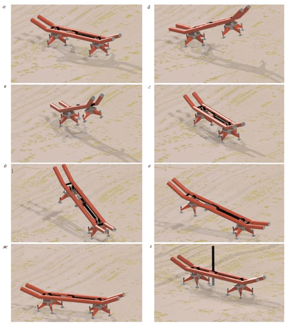
Fig.6. Sequence of the walking device movement along the bottom surface of the lake: а – initial position of the walking device on the bottom surface; b – raising the first support by shifting the counterbalances; c – rotation relative to the second support; d – lowering of the first support by shifting the counterbalances; e – raising the second support by shifting the counterbalances; f – rotation relative to the first support; g – lowering of the second support by shifting the counterbalances; h – drilling setup is set to the working position
Then the walking cycle is repeated with respect to the other support (Fig.6, e, f, g), and this continues until the device moves in accordance with the specified plan of research works to a point with a given coordinate. At the point with the given coordinate, the drilling setup is set into working position (Fig.6, h) and the sampling takes place, then the walking device is lifted on the carrying cable to the delivery equipment, transferred to the transport position and elevated to the surface in the delivery equipment.
The considered walking device is a universal transport support, on which various types of research equipment can be placed. For example: drilling setup for sampling (as shown in Fig.5 and 6); geophysical equipment for studying the bottom surface; samplers for sampling water and bottom sediments and much more.
The walking device is planned to be equipped with telemetry means, which will make it possible to control the processes of movement and perform research work remotely. The power supply for the drives of the walking device and research apparatus, as well as the transmission of information and control signals, will be carried out through the carrying cable. The design of the sampling equipment will take into account the results of previous laboratory and field work by Russian [41] and foreign [10, 31] scientists.
The technological parameters of the walking device and research apparatus will depend on the size of the delivery equipment, which is limited by the diameter of the access well. Specific values of technological parameters will be presented in subsequent publications based on the results of planned investigations.
However, it can already be stated that the planned research and pilot works will be aimed at creating a structure that provides the necessary “purity” of the samples, the unit sample volume and the required number of samples from a given study site.
Results achieved and planned research
In accordance with the proposed technology for sampling the bottom surface of the subglacial Lake Vostok (Fig.3), the conceptual schematic diagram of the delivery equipment (Fig.4) and the design of the walking device (Fig.5) were developed. The process of moving the walking device along the bottom surface was modeled.
- Ensure environmental safety at all stages of working of the walking device.
- Ensure the operability of all units and parts of the walking device.
- Place the walking device in the transport position in the delivery equipment, the diameter of which will be equal to the diameter of the sampling pipes used when drilling.
- Ensure the reliability of the transfer of the walking device from the transport position to the working position and back.
- Ensure the control of the positioning of the walking device on the bottom surface.
- Develop various types of equipment for sampling and investigation of the bottom surface.
- Ensure maximum efficiency in the use of sampling equipment under various operating conditions.
To solve these issues, it is planned to carry out kinematic, dynamic and durability calculations; perform solid modeling of all work stages; create a working model of the walking device and carry out bench tests with it.
Conclusion
Based on the analysis of implemented subglacial research projects, the following conclusions can be drawn:
- In order to carry out the work to penetrate and study the subglacial Lake Vostok, a new infrastructure needs to be created at the existing station to ensure that the set objectives can be met – a living and drilling structure.
- The known technologies for penetrating and investigating subglacial lakes cannot be adapted for application to Lake Vostok due to its unique characteristics (extremely low temperature of the glacier upper layers, glacier thickness, lake depth, etc.) and high altitude conditions of “Vostok” station, but their individual elements can be taken into account when developing new technologies.
- The technology being developed for the penetrating and study of the subglacial Lake Vostok should, first of all, ensure the environmental safety of the work carried out, and the technical means of its implementation should ensure reliability and fail-safety.
The main advantage of the proposed technology, in comparison with other technologies, is the greater mobility of the walking device, which allows selective sampling of rocks from a specific area on the bottom surface, using only one access well. In addition, the possibility of equipping the walking device with various types of samplers, as well as various scientific research equipment, makes it possible to increase the invariance and efficiency of the study of the subglacial Lake Vostok. For the implementation of this technology, it is necessary to solve a large number of problems of a scientific, engineering and practical nature.
References
- Vasilev N.I., Leichenkov G.L., Zagrivny E.A. Prospects of obtaining samples of bottom sediments from subglacial lake Vostok. Journal of Mining Institute. 2017. Vol. 224, p. 199-208. DOI: 10.18454/PMI.2017.2.199
- Leichenkov G.L., Belyatskii B.V., Popkov A.M., Popkov S.V. The geological nature of the subglacial Lake Vostok in East Antarctic. Materialy glyatsiologicheskikh issledovanii. 2005. N 98, p. 81-91 (in Russian).
- Litvinenko V.S. Unique engineering and technology for drilling boreholes in Antarctic ice. Journal of Mining Institute. 2014. Vol. 210, p. 5-10 (in Russian).
- Lukin V.V. A way to Lake Vostok studies is now open. Arctic and Antarctic Research. 2012. N 1(91), p. 5-19 (in Russian).
- Popov S.V., Chernoglazov U.B. Subglacial Lake Vostok, East Antarctic: coastline and surrounding bodies of water. Led i Sneg. 2011. N 1 (113), p. 13-24 (in Russian).
- Popov S.V., Masolov V.N., Lukin V.V. Lake Vostok, East Antarctica: glacier thickness, lake depth, subglacial and bedrock relief. Led i Sneg. 2011. N 1 (113), p. 25-35 (in Russian).
- Masolov V.N., Popov S.V., Popkov A.M., Lukin V.V. The bottom topography and subglacial Lake Vostok water body, East Antarctica. Doklady Earth Sciences. 2010. Vol. 433. N 2, p. 1092-1097. DOI: 10.1134/S1028334X10080222
- Lipenkov V.Y., Ekaykin A.A., Alekhina I.A. et al. Evolution of climate, glaciation and subglacial environments of Antarctica from the deep ice core and Lake Vostok water sample studies (Key results of implementation of the Russian Science Foundation project, 2014-2016). Ice and Snow. 2017. Vol. 57. N 1, p. 133-141. DOI: 10.15356/2076-6734-2017-1-133-141 (In Russian).
- Kapitsa A.P., Ridley J.K., Robin G. de Q. et al. A large deep freshwater lake beneath the ice of central East Antarctica. Nature. 1996. Vol. 381, p. 68-686. DOI: 10.1038/381684a0
- Timoney R., Worrall K., Firstbrook D. et al. A low resource subglacial bedrock sampler: The percussive rapid access isotope drill (P-RAID). Cold Regions Science and Technology. 2020. Vol. 177. N 103113. DOI: 10.1016/j.coldregions.2020.103113
- Siegert M., Makinson K., Blake D. et al. An assessment of deep hot-water drilling as a means to undertake direct measurement and sampling of Antarctic subglacial lakes: Experience and lessons learned from the Lake Ellsworth field season 2012/13. Annals of Glaciology. 2014. Vol. 55. Iss. 65, p. 59-73. DOI: 10.3189/2014AoG65A008
- Siegert M., Priscu J., Alekhina I. et al. Antarctic subglacial lake exploration: First results and future plans. Philosophical Transactions of the Royal Society A: Mathematical, Physical and Engineering Sciences. 2016. Vol. 374. Iss. 2059. N 0466. DOI: 10.1098/rsta.2014.0466
- Blythe D., Duling D., Gibson D. Developing a hot-water drill system for the WISSARD project: 2. In situ water production. Annals of Glaciology. 2014. Vol. 55. Iss. 68, p. 298-302. DOI: 10.3189/2014AoG68A037
- Construction of the Vostok station living module completed in the Leningrad region. URL: https://ria.ru/20200827/kompleks-1576399846.html (date of access 1.09.2020).
- Siegert M., Clarke R., Mowlem M. Clean access, measurement, and sampling of Ellsworth Subglacial Lake: A method for exploring deep Antarctic subglacial lake environments. Reviews of Geophysics. 2012. Vol. 50. Iss. 1. RG000361. DOI: 10.1029/2011RG000361
- Burnett J., Rack F., Blythe D. et al. Developing a hot-water drill system for the WISSARD project: 3. Instrumentation and control systems. Annals of Glaciology. 2014. Vol. 55. Iss. 68, p. 303-310. DOI: 10.3189/2014AoG68A039
- Rack F., Duling D., Blythe D. et al. Developing a hot-water drill system for the WISSARD project: 1. Basic drill system components and design. Annals of Glaciology. 2014. Vol. 55. Iss. 68, p. 285-297. DOI: 10.3189/2014AoG68A031
- Fujita S., Yamada T., Naruse R., Mae S., Azuma N., Fujii Y. et al. Drilling fluid for Dome F Project in Antarctica. Memoirs of National Institute of Polar Research. 1994. Special iss. 49, p. 347-357.
- Dvoynikov M.V., Nutskova M.V., Blinov P.A. Developments Made in the Field of Drilling Fluids by Saint Petersburg Mining University. International Journal of Engineering. 2020. Vol. 33. Iss. 4, p. 702-711. DOI: 10.5829/ije.2020.33.04a.22
- Talalay P., Hu Z., Xu H. et al. Environmental considerations of low-temperature drilling fluids. Annals of Glaciology. 2014. Vol. 55. Iss. 65, p. 31-40. DOI: 10.3189/2014AoG65A226
- Leitchenkov G.L., Antonov A.V., Luneov P.I., Lipenkov V.Ya. Geology and environments of subglacial Lake Vostok. Philosophical Transactions of the Royal Society A. 2016. Vol. 374. Iss. 2059. N 0302. DOI: 10.1098/rsta.2014.0302
- Fisher A., Mankoff K., Tulaczyk S. et al. High geothermal heat flux measured below the West Antarctic Ice Sheet. Science Advances. 2015. Vol. 1. Iss. 6. N e1500093-e1500093. DOI: 10.1126/sciadv.1500093
- Litvinenko V.S., Leitchenkov G.L., Vasiliev N.I. Anticipated sub-bottom geology of Lake Vostok and technological approaches considered for sampling. Geochemistry. 2020. Vol. 80. Iss. 3. N 125556. DOI: 10.1016/j.chemer.2019.125556
- Litvinenko V., Dvoynikov M.V., Trushko V.L. Elaboration of a conceptual solution for the development of the Arctic shelf from seasonally flooded coastal areas. International Journal of Mining Science and Technology (in press). DOI: 10.1016/j.ijmst.2021.09.10
- Litvinenko V. Foreword: Sixty-year Russian history of Antarctic sub-glacial lake exploration and Arctic natural resource development. Geochemistry. 2020. Vol. 80. Iss. 3. N 125652. DOI: 10.1016/j.chemer.2020.125652
- Woodward J., Smith A., Ross N. Location for direct access to Subglacial Lake Ellsworth: An assessment of geophysical data and modeling. Geophysical Research Letters. 2010. Vol. 37. Iss. 11. N L11501. DOI: 10.1029/2010GL042884
- Mikhalsky E.V., Skublov S.G. First data on U-Pb age of mafic dyke in the Mirny Station area (Pravdy Coast, East Antarctica). Geochemistry. 2020. Vol. 80. Iss. 3. N 125480. DOI: 10.1016/j.chemer.2018.10.001
- Timofeev I.P., Sokolova G.V., Kolton G.A. et al. Patent N 2601880. Walking machine for underwater mining. Viewed: 10.11.2016.
- Timofeev I.P., Sokolova G.V., Korolev I.A. et al. Patent N 166446. Walking mining machine. Viewed: 27.11.2016.
- Hodson T., Powell R., Brachfeld S.A. et al. Physical processes in Subglacial Lake Whillans, West Antarctica: Inferences from sediment cores. Earth and Planetary Science Letters. 2016. Vol. 444, p. 56-63. DOI: 10.1016/j.epsl.2016.03.036
- Liu N., Xu H., Yang Y. et al. Physicochemical properties of potential low-temperature drilling fluids for deep ice core drilling. Cold Regions Science and Technology. 2016. Vol. 129, p. 45-50. DOI: 10.1016/j.coldregions.2016.06.004
- Mikhalsky E.V., Krylov D., Rodionov N. et al.Refined geological history of the polyphase plutonometamorphic complex in the Thala Hills area (Enderby Land, East Antarctica) from zircon SHRIMP dating and implications for Neoproterozoic amalgamation of Gondwanaland Geological Society. 2017. Vol. 457, p. 7-36. DOI: 10.1144/sp457.2
- Priscu J., Kalin J., Winans J. et al. Scientific access into Mercer Subglacial Lake: Scientific objectives, drilling operations and initial observations. Annals of Glaciology. 2021. Vol. 62. Iss. 85-86, p. 340-352. DOI: 10.1017/aog.2021.10
- Fricker H., Powell R., Priscu J. et al. Siple Coast Subglacial Aquatic Environments: The Whillans Ice Stream Subglacial Access Research Drilling Project. Antarctic Subglacial Aquatic Environments (Geophysical Monograph Series). American Geophysical Union, 2011. Vol. 192, p. 199-219. DOI: 10.1002/9781118670354.ch12
- Siegert M. Proposed Exploration of Subglacial Lake Ellsworth. Antarctica Final Comprehensive Environmental Evaluation. British Antarctic Survey. Technical report. Lake Ellsworth Antarctica, 2012, p. 87.
- Talalay P. Subglacial till and bedrock drilling. Cold Regions Science and Technology. 2013. Vol. 86, p. 142-166. DOI: 10.1016/j.coldregions.2012.08.009
- Hodgson D., Bentley M., Smith J. et al. Technologies for retrieving sediment cores in Antarctic subglacial settings. Philosophical Transactions of the Royal Society A: Mathematical, Physical and Engineering Sciences. 2016. Vol. 374. Iss. 2059. N 20150056. DOI: 10.1098/rsta.2015.0056
- Triest J., Alemany O. Drill fluid selection for the SUBGLACIOR probe: A review of silicone oil as a drill fluid. Annals of Glaciology. 2014. Vol. 55. Iss. 68, p. 311-321. DOI: 10.3189/2014AoG68A028
- Tulaczyk S., Mikucki J., Siegfried M. et al.WISSARD at Subglacial Lake Whillans, West Antarctica: Scientific operations and initial observations. Annals of Glaciology. 2014. Vol. 55. Iss. 65, p. 51-58. DOI: 10.3189/2014AoG65A009
- WISSARD About. URL: http://www.wissard.org/about (date of access 21.07.2020).
- Vasilev N.I., Bolshunov A.V., Ignatiev S.A. Inertial mechanical reamer for borehole 5G-3 conditioning for penetration into subglacial lake Vostok. International Journal of Applied Engineering Research. 2017. Vol. 11. N 5, p. 561-566.