Geological structure of the northern part of the Kara Shelf near the Severnaya Zemlya archipelago according to recent studies
- 1 — Ph.D. Deputy General Director VNIIOkeangeologia ▪ Orcid ▪ Elibrary ▪ Scopus ▪ ResearcherID
- 2 — Ph.D. leading researcher VNIIOkeangeologia ▪ Orcid ▪ Elibrary ▪ Scopus ▪ ResearcherID
- 3 — principal engineer VNIIOkeangeologia ▪ Orcid
- 4 — principal engineer VNIIOkeangeologia ▪ Orcid ▪ Elibrary ▪ Scopus
- 5 — principal engineer VNIIOkeangeologia ▪ Orcid ▪ Elibrary ▪ Scopus

Abstract
Until recently, the North of the Kara Shelf was completely unexplored by seismic methods. Seismic and seismo-acoustic data that have appeared in recent years have made it possible to decipher features of the regional geological structure. This study solves the urgent problem of determining the prospects for the oil and gas potential of the North Kara sedimentary basin. The relevance of the research is associated with determining the prospects of the oil and gas potential of the North Kara sedimentary basin. The aim of the study is to clarify the age of the reflecting horizons using data on the geology of the island, as well as to determine the tectonic position of the sedimentary cover and basement structures in the north of the Kara shelf. The sedimentary cover is divided into three structural levels: Cambrian-Devonian, Middle Carboniferous-Cretaceous, Miocene-Quarter. The Cambrian-Devonian complex fills the deep troughs of the North Kara shelf. The most noticeable discontinuity is the base of Carboniferous-Permian rocks, lying on the eroded surface of folded Silurian-Devonian seismic complexes. The blanket-like plate part of the cover is composed of thin Carbon-Quarter complexes. The authors came to the conclusion that the fold structures of the Taimyr-Severozemelskiy fold belt gradually degenerate towards the Kara sedimentary basin and towards the continental slope of the Eurasian basin of the Arctic Ocean. A chain of narrow uplifts within the seabed relief, which correspond to narrow anticlines is traced to the West of the Severnaya Zemlya islands. Paleozoic rocks have subhorizontal bedding further to the West, within the Kara shelf. Mesozoic folding in the North of the Kara Sea is expressed exclusively in a weak activation of movements along faults. At the neotectonic stage, the shelf near Severnaya Zemlya was raised and the Mesozoic complexes were eroded. The modern seismic activity of the North Zemlya shelf is associated with the ongoing formation of the continental margin.
None
Introduction. In geotectonic terms, the Northern part of the Kara shelf is an area where continental and oceanic structures of different orders meet. The area is rather poorly studied due to its significant ice coverage, which has noticeably decreased in recent years, it finally allowed to carry out seismic reflection surveys, as well as seismo-acoustic profiling. Prior to seismic work, knowledge about the geology of the north of the Kara shelf was based solely on the results of interpretation of the potential fields.
Back in 1932 N.N.Urvantsev suggested that Severnaya Zemlya was a part of a thick folded arc, probably of post-Permian age. According to the 1:1 000 000 scale geological mapping, the structures of Severnaya Zemlya were interpreted as the result of a long-term development of the geosyncline, with the central zone located within the Bolshevik island formed in the Proterozoic time, and the northern part (the October Revolution and Komsomolets islands) completed its development in the Caledonian cycle of tectogenesis. The surveyors who mapped the southern part of Severnaya Zemlya in 2008-2009 came to the same conclusion [1]. According to B.Kh.Egiazarov, the archipelago has been developing in platform environments since the Ordovician. “Post-Devonian structures of an intermediate type” were formed in the Hercynian time within the western part of the archipelago (B.Kh.Egiazarov, 1959). According to Yu.E.Pogrebitsky, starting from the Late Riphean, the regions of Taimyr and Severnaya Zemlya were developing in platform environments and did not experience Caledonian folding. Pogrebitsky suggests that activation stage began in the middle of the Carboniferous and lasted in the Late Paleozoic and Triassic periods.
Based on the materials of the 1: 200 000 scale sedimentary cover mapping of the Severnaya Zemlya archipelago, three structural levels were distinguished, the boundaries between which were established according to angular and stratigraphic unconformities: lower – Upper Proterozoic to Upper Devonian, middle – Middle Carboniferous to Upper Permian, and upper – Neogene to Quaternary.
The aim of the study is to generalize geological and geophysical data and interpret the seismo-acoustic materials obtained by the authors to clarify the structural features and geological evolution of the North Kara region. The results of the study were used by the authors to compile and prepare for publication a sheet of the State Geological Map of the Russian Federation at a scale of 1: 1 000 000 U-45, 46, 47, 48 (Komsomolets Island). The practical relevance of the research consists in the development of a tectonic basis for assessing the prospects for the regional oil and gas potential.
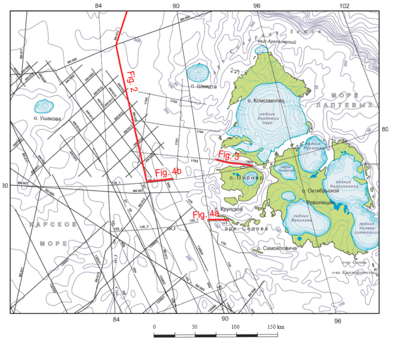
Materials and methods of research. In this study, we used materials from geological surveys of the Severnaya Zemlya archipelago, as well as new geophysical data on the adjacent Kara Sea shelf (Fig.1). The study is based on the results of regional survey realized by CDP seismic reflection method by JSC Sevmorneftegenofizika (2005, 2007 and 2008) [8] and JSC Marine Arctic Geological Expedition (2016) [14]. In addition to these works, in the North of the Kara shelf, Regional CDP seismic reflection profiling was carried out under the “Geology Without Borders” project. Some of the profiles are already published [13]. CDP seismic reflection profiles with survey polygons located 50-100 km from the coast of the archipelago were used to develop a geological structure model. Seismo-acoustic studies in the transit zone, conducted by VNIIOkeangeologia in 2017, and the same materials obtained by the Polar Marine Geosurvey Expedition in 2008 and 2009 [4] used to correlate shelf geophysical and terrestrial geological data. The authors of the article took part in the field studies in 2008-2009 and 2017, in particular in seismoacoustic profiling and interpretation of the obtained data. Continuous seismo-acoustic profiling was carried out using a sparker with a power not exceeding 2.5 kJ. A single-channel receiver and an intermediate frequency range of 250-1000 Hz were used during the profiling operations. The deep structure of this area was deciphered according to the deep seismic sounding data along the 3-AR and 4-AR profiles [7, 11], as well as potential fields data.
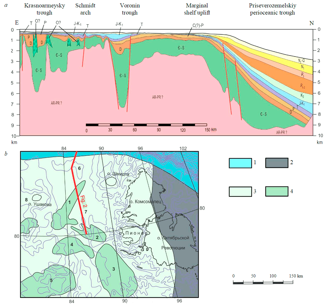
Results. The basis of the geological structure model was the scheme of sedimentary section subdivision, adopted for the seismic works carried out in the North of the Kara shelf by JSC Sevmorneftegeofizika and JSC Marine Arctic Geological Expedition. The reflecting seismic horizons were tied to by the well on Sverdrup Island, as well as to the coastal sections of Novaya Zemlya and Severnaya Zemlya [10]. The thickness of the sedimentary cover within the northern part of the Kara Sea varies from 0.3 to 5.5 sec (0.25-8 km).
On the CDP seismic reflection profiles the regional seismic horizons are traced, which divide the sedimentary cover into seven seismic stratigraphic complexes from the acoustic basement to the seabed [14]. The lowest reflector is the acoustic basement surface, which appears to be the top of the Archean-Proterozoic crystalline basement. The folded basement dating of the Severnaya Zemlya islands varies in following range: there are blocks of Baikalian stabilization, areas of Caledonian folding, as well as blocks affected by either the Hercynian folding or final stage of the Caledonian one [12, 15, 16]. In contrast to the Bolshevik and the October Revolution islands, on the northern islands of the archipelago, the degree of Paleozoic rocks deformation is noticeably less. In the northern and western directions, towards the Eurasian basin and the North Kara sedimentary basin, folded structures gradually flatten out and pass into cover bedding, which can be seen on seismic profiles (Fig.2).
Downwarping and depressions in the basement are filled with the Cambrian-Silurian complex with clinoform structure in general. By analogy with units of the same age cropping out on Severnaya Zemlya, the complex is represented by limestones, dolomites, less often – siltstones, argillite, and sandstones. Gypsum and salts are not rare and, according to seismic studies, often form diapirs and stocks [2, 6].The overlying Devonian complex is characterized by a change of the Early Paleozoic carbonate sedimentation by terrigenous one. Devonian rocks on the islands are represented by red and green sandstones, siltstones and argillites. There are no Carboniferous and Lower Permian formations within the islands, while, shelf territory contains Middle Carboniferous (?)-Permian seismic complex, presumably composed of siltstones, argillites, and, to a lesser extent, sandstones. Its basement forms the most pronounced structural discordance in the sedimentary cover of the North Kara sedimentary basin.
The East Kara megafold is identified as part of the Kara sedimentary basin. It is complicated by the Ushakov and Vize arches, as well as the Schmidt, Voronin and Krasnoarmeysky trough [14]. The Voronin trough is the most contrasting rift-induced structure. Its northeastern trough is crossed by the seismic profile (Fig.2). The length of the Voronin trough is more than 50 km, the width is 20 km, the thickness of the sedimentary filling is more than 7 km. The structures of salt diapirs and stocks are widely presented within the shallower Krasnoarmeysky trough.
Paleozoic rocks are eroded within horsts and overlie by Mesozoic, less often – Late Cenozoic rocks. Argillites and siltstones are assumed as part of the Triassic seismic complex. The Jurassic seismic complex is also characterized by a clayey composition, while the Cretaceous seismic complex is composed of coarser varieties – sands, siltstones, with an admixture of clayey material.
Previously, Paleogene rocks were assumed as part of the sedimentary cover of the Kara shelf. But, according to new seismic data, the Cenozoic deposits are developed within the continental margin, while the Miocene-Quaternary sediments, which make up the uppermost seismic complex, are widespread on the shelf. The upper seismic complex is predominantly composed by pebblestones, gravels, coarse-grained sands, silts, less often clays.
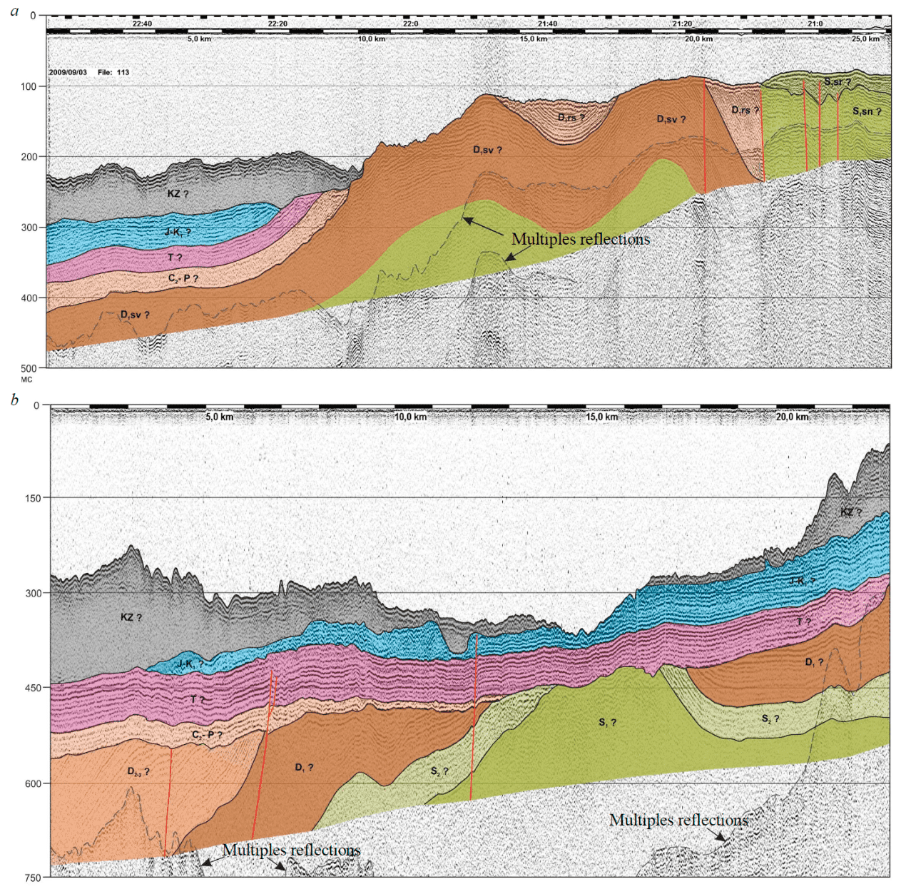
Seismo-acoustic profiles allow to reveal only the upper part of the sedimentary cover, which is usually represented by the Miocene (?)-Quaternary seismic complex overlapping the Mesozoic and Paleozoic formations. The angular unconformity cutting the Ordovician-Devonian rocks is clearly fixed on the profiles traversed in 2008-2009 and approaching directly to the islands of the Sedov archipelago, as well as to the Pioneer island [4].
One of the seismo-acoustic profiles (N 1903) runs from the Red Army Strait through the Yuny Strait to the open part of the Kara Sea. The record contains weakly folded structures of Paleozoic rocks outcropped along the shores of the Yuny Strait on the Komsomolets and Pioner islands (Fig.3). In the cores of the anticline folds, the Lower Silurian rocks of the Sredninskaya suite protrude on the surface of the seabed, and in the syncline folds, the Middle Devonian rocks of the Albanovskaya suite. Typically, on the shallow shelf around the Severnaya Zemlya islands, there is a straight seabed relief, corresponding to tectonic structures: uplifts and ridges correspond to anticline fold, depressions and troughs – to syncline ones (Fig.3).

Discussion. Recently obtained data on the Kara shelf adjacent to Severnaya Zemlya significantly improve the understanding of the regional geological structure. Even in the absence of parametric wells in the North of the Kara Sea, the network of seismo-acoustic and seismic profiles made it possible to trace the sedimentary cover complexes outcropped along the shores of the Severnaya Zemlya islands to the open part of the shelf. Folded Silurian and Devonian rocks can be traced from the islands to the west. A chain of linear ridges of the seabed relief corresponding to the anticlines cores can be traced 10-20 km away from the coast. Within the ridges, the reflector dips increase so much that they are barely recorded by seismic techniques, approaching the resolution limit. Further, more seaward in the direction of the Kara shelf, the inclination angles of deformed Paleozoic rocks decrease to disappearance and sub-horizontal occurrence.
Monoclinal bedding of sedimentary cover rocks, with pinch-out of younger (Cretaceous) seismic complexes in the area of the St.Anna Trough, is observed along the northern part of the Kara shelf. Further to the East, Jurassic and Triassic rocks pinch out, and even more eastwards, near the Severnaya Zemlya islands, Paleozoic rocks protrude on the bottom surface. The folding degree of the Paleozoic part of the cover, according to the reflector dips, rapidly become weaker from East to West and from South to North. The sublatitudinal profiles show a strong angular unconformity between Devonian and Late Carboniferous-Permian and Mesozoic rocks (Fig.4). This is due to the fact that the region experienced the greatest uplift and erosion during the Hercynian time: for example, the thickness of the sedimentary cover on the Vize uplift decreased by 2.5 km during the Late Carboniferous-Permian periods [5].
According to geophysical data, the strongest structural unconformity also has a Middle Carboniferous age, when the Severozemelskaya folding ended. The unconformity separates the two lower structural levels characterizing the structure of the sedimentary cover of the North Kara shelf [14]. The angular unconformity at the base of the Ordovician complex, recorded in the structure of the Severnaya Zemlya section and confidently traced in the southern part of the North Kara basin [5], becomes secondary and lost in its northern part. The sedimentary cover in the North Kara basin, in contrast to Severnaya Zemlya, contains Mesozoic terrigenous seismic complexes.
Thus, within the limits of the North Kara shelf in the Cambrian-Devonian time, there were rather deep troughs and uplifts separating them. Coastal-marine carbonate and carbonateterrigenous sediments, including salts and gypsum accumulated in the shallow parts of the basin [9]. In deep riftogenic structures such as the Voronin trough, sedimentation rates were significant, and flysch deposits accumulated there. The sedimentary cover of the North Kara basin is weakly deformed by folding processes that extended up to the Carboniferous period from the TaimyrSeverozemelskaya fold zone. The accumulation of shallow-water shelf sediments within a single North Kara sedimentary basin begins only from the Carboniferous-Permian time. The thin cover of Permian and Triassic-Jurassic sediments is subhorizontal, sheetlike, and is practically unaffected by fold and disjunctive dislocations. Thus, the Mesozoic folding on the shelf led only to weak tectonic movements along faults, diving into the Triassic and Jurassic seismic complexes. Nevertheless, the region was affected by neotectonic processes, as a result of which the near Severnaya Zemlya part of the Kara shelf was involved in the uplift and was a denudation area in the Early Cenozoic. This was reflected in the erosion of the Cretaceous and Jurassic sediments, and the general monoclinal slope of the entire sediment sequence. At present, evidence of neotectonic processes are earthquakes with medium magnitudes within the Severnaya Zemlya archipelago and surrounding shelf structures [3]. Miocene (?)-Quaternary deposits of the uppermost seismic complex are thin and discontinuous. Its considerable thickness is observed within the foot of the Voronin trough slopes, where the deposits has landslide origin according to the obtained records.
In the north, the Kara shelf structures are cut by the superimposed oceanic formations. The modern continental slope corresponds to the continent-ocean transition zone, which separates the shelf structures from the Nansen deep-water oceanic basin [17]. On seismic sections, this area is characterized by subsidence of the basement and an increase in sediment thickness (Fig.2). The clinoform complex of the continental slope is composed of Mesozoic-Cenozoic terrigenous rocks.
Conclusions. As a result of the study, we have determined the type of seismo-acoustic recording of Paleozoic rocks in the straits and bays of Severnaya Zemlya. We also tracked seismic complexes of Paleozoic rocks within the open part of the Kara Sea shelf. The upper unconformities on the CDP seismic reflection and seismo-acoustic profiles are compared. Direct tracing of all horizons is hampered by the deformation zone located to the West of the Severnaya Zemlya islands. The brightest and most contrasting is the base of the Middle Carboniferous (?)-Permian seismic complex, which lie unconformably on eroded Silurian and Devonian rocks. The plate part of the sedimentary cover of the North Kara Shelf is represented by horizontally lying thin strata of the Middle Carboniferous (?)-Permian, Triassic, and Jurassic-Cretaceous age. At present, a part of the shelf adjacent to the island has been uplifted, with the erosion of Mesozoic rocks. The uppermost Late Cenozoic seismic complex is thin and extremely unstable along the strike. It seems advisable to further study the North Kara shelf with the drilling of a parametric, as well as stratigraphic and exploration wells. According to seismic data, there are potentially oil and gas bearing structures within the shelf.
References
- Makariev A.A., Makarieva E.M. New Data on the Age of Some Geological Formations on the Islands and Coast of the East-ern Part of Kara Sea. Razvedka i ohrana nedr. 2012. N 8, p. 71-77 (in Russian).
- Malyshev N.A., Nikishin V.A., Obmetko V.V., Kleshchina L.N., Reydik Yu.V., Nikishin A.M., Martirosyan V.N. A new model of the geological structure and evolution of the North Kara sedimentary Basin. Doklady Akademii nauk. 2012. Vol. 445. N 1, p. 791-795. DOI: 10.1134/S1028334X12070057 (in Russian).
- Antonovskaya G.N., Kovalev S.M., Konechnaya Y.V., Smirnov V.N., Danilov A.V. New information about the seismicity of the Russian Arctic based on the work of the seismic station “Severnaya Zemlya”. Arctic and Antarctic Research. 2018. Vol. 64. N 2. P. 170-181. DOI: 10.30758/0555-2648-2018-64-2-170-181 (in Russian).
- Gusev Е.А., Sharin V.V., Dymov V.A., Kachurina N.V., Arslanov Kh.A. New data on the upper horizons of the sedimentary cover of the northern part of the Kara sea shelf. Razvedka i ohrana nedr.2012. N 8, p. 87-90 (in Russian).
- Verzhbitsky V.E. Murzin R.R.,Vasilyev V.E.,Malysheva S.V., Ananyev V.V., Komissarov D.K., Roslov Yu.V. New Look at the Seismic Stratigraphy and Hydrocarbon Systems of Paleozoic Sedimentary Rocks of North Kara Shelf. Oil Industry. 2011. N 12, p. 18-21 (in Russian).
- Malyshev N.A., Nikishin V.A., Obmetko V.V., Kleshchina L.N., Nikishin A.M. The ordovician urvantsev evaporite basin in the northern part of the Kara Sea. Doklady Akademii nauk. 2013. Vol. 448. N 2, p. 157-160. DOI: 10.1134/S1028334X13020062 (in Russian).
- Sakoulina T.S., Pavlenkova G.A., Kashubin S.N. Structure of the Earth's crust in the northern part of the Barents-Kara region along the 4-AR DSS profile. Russian Geology and Geophysics. 2015. Vol. 56. N 11, p. 1622-1633. DOI: 10.1016/j.rgg.2015.10.008 (in Russian).
- Martirosyan V.N., Vasiliev E.A., Oystritsky V.I., Suprunenko O.I., Vinokurov I.Yu. The North of the Kara Sea is a highly promising oil region of the Arctic shelf of Russia. Oil and gas geology. 2011. N 6, p. 59-69 (in Russian).
- Daragan-Sushchova L.A., Petrov O.V., Daragan-Sushchov Y.I., Vasilev M.A. Structure of the North Kara Shelf from results of seismostratigraphic analysis. Geotektonika. 2014. Vol. 48. N 2, p. 139-150. DOI: 10.1134/S0016852114020022 (in Russian).
- Dolgunov K.A., Martirosyan V.N., Vasiliev E.A., Sapozhnikov B.G. Structural and tectonic structural features and oil and gas prospects in the northern part of the Barents-Kara region. Russian Oil and Gas Geology. 2011. N 6, p. 70-83 (in Russian).
- Ivanova N.M., Sakulina T.S., Belyaev I.V., Matveev Yu.I., Roslov Yu.V. Depth model of the Barents and Kara seas ac-cording to geophysical surveys results. Geological Society. London: Memoirs. 2011. Vol. 35, p. 209-221. DOI: 10.1144/M35.12
- Ershova V., Anfinson O., Prokopiev A., Khudoley A., Stockli D., Faleide J.I., Gaina C., Malyshev N. Detrital zircon (U-Th)/He ages from Paleozoic strata of the Severnaya Zemlya Archipelago: Deciphering multiple episodes of Paleozoic tectonic evolution within the Russian High Arctic. Journal of Geodynamics. 2018. Vol. 119, p. 210-220. DOI: 10.1016/j.jog.2018.02.007
- Nikishin A.M., Freiman S.I., Gaina C., Petrov E.I., Malyshev N.A. Eurasia basin and Gakkel ridge, Arctic ocean: crustal asymmetry, ultra-slow spreading and continental rifting revealed by new seismic data. Tectonophysics. 2018. Vol. 746, p. 64-82. DOI: 10.1016/j.tecto.2017.09.006
- Fomina E., Kirillova-Pokrovskaya T., Pavlov S. The Structure of the Barents – Kara Continental Margin. Conference Pro-ceedings, Saint Petersburg 2018. Vol. 2018, p. 1-5. DOI: 10.3997/2214-4609.201800303
- Khudoley A.K., Verzhbitsky V.E., Zastrozhnov D.A., O’Sullivan P., Ershova V.B., Proskurnin V.F., Tuchkova M.I., Rogov M.A., Kyser T.K., Malyshev S.V., Schneider G.V. Late Paleozoic – Mesozoic tectonic evolution of the Eastern Taimyr-Severnaya Zemlya Fold and Thrust Belt and adjoining Yenisey-Khatanga Depression. Journal of Geodynamics. 2018. Vol. 119, p. 221-241. DOI: 10.1016/j.jog.2018.02.002
- Lorenz H., Gee D.G., Simonetti A. Detrital zircon ages and provenance of the Late Neoproterozoic and Palaeozoic succes-sions on Severnaya Zemlya, Kara Shelf: a tie to Baltica. Norwegian Journal of Geology. 2008. Vol. 88, p. 235-258.
- Avetisov G.P., Butsenko V.V., Chernykh A.A., Firsov Y.G., Glebovsky V.Yu., Gusev E.A., Kireev A.A., Krylov A.A., Zinchenko A.G. The Current State of the Arctic Basin Study. Geologic Structures of the Arctic Basin. Springer, Cham, 2019, p. 1-69. DOI: 10.1007/978-3-319-77742-9_1