Oil and gas content of the understudied part in the northwest of the Timan-Pechora oil and gas province according to the results of basin modeling

Abstract
Comprehensive interpretation of the results for regional seismic operations and reinterpretation of archived seismic data, their correlation with the drilling data of more than 30 deep wells, including Severo-Novoborsk parametric well, made it possible to clarify the structural maps and thickness maps of all seismic facies structures developed in the territory and water area in the junction of the north of Izhma-Pechora depression and Malozemelsko-Kolguevsk monocline of Timan-Pechora oil and gas province. Data obtained were used at basin modeling in TemisFlow software in order to reconstruct the conditions of submersion and transformation of organic substance in potential oil and gas bearing formations. Modeling made it possible to get an idea of the time and conditions for the formation of large zones of possible hydrocarbons accumulation, to establish space-time connections with possible sources of generation, to identify the directions of migration and on the basis of comparison with periods of intense generation, both from directly located within the operation area and outside them (taking into account possible migration), to identify zones of paleoaccumulation of oil and gas. Work performed made it possible to outline promising oil and gas accumulation zones and identify target objects for further exploration within the site with an ambiguous forecast and lack of industrial oil and gas potential.
None
Introduction.
The area of investigation covers the northwestern part of the Timan-Pechora sedimentary basin (TPSB). It formed during the Phanerozoic on the denudation surface of metamorphosed shale and volcanogenic formations of the ceased-existing “dead” paleobasin of the Riphean-Vendian (Baikalian) consolidation, and became the Timan-Pechora epibaikalian plate (TPEBP).
Age of sedimentary formations. Considered sedimentation basin is composed of formations from late Cambrian – lower Ordovician to Neogene and Quaternary sediments (510-0.01 million years). Age of the formations was established based on stratigraphic investigations of the rock samples from drilled wells. Tests determined the geological age by paleontological remains [6] and the absolute age by isotopes of mineral inclusions in sedimentary rocks and magmatogenic intrusions, as well as using seismic reflecting surfaces. According to the prevailing number and volume of formations participating in the structure of the TPSB, its age is Paleozoic-early Mesozoic (Triassic) [5, 26], later formations are presented in insignificant volumes.
Geographical location and area. Timan-Pechora sedimentary basin is located in the northeast of the European part of Russia, between 64 and 70° north latitude and 47 and 60° east longitude. It has trapezium contours stretched in the northwest direction. Its area is estimated (total land and sea) at more than 450 thousand km2, of which two-thirds are located on land and more than 180 thousand km2 in the northern part is covered by Pechora Sea (southern part of the Barents Sea) with islands. The largest island – Kolguev (4400 thousand km2) – is located in the western part of the Pechora Sea, 75 km from land (Fig.1).
Geological and geophysical exploration state. TPSB is well studied in the course of seismic exploration (average density of seismic exploration profiles exceeds 2 km/km2) in the central and southern parts and is poorly studied in the northwestern and far eastern parts. Density of seismic exploration operations, as well as drilling, is not uniform. The highest density of CDP profiles is 1.5-2.2 km/km2 at megaswells: Pechora-Kolvinsk and southeast of Pechora-Kozhvinsk, in the Khoreyver depression. Density decreases to 0.8-1.5 km/km2 on the Shapkin-Yuryakhinsk swell and in the Varandey-Adzvinsk structural zone. The lowest density (0.1-0.8 km/km2) is in the northern half of the Izhma-Pechora syneclise. In the sedimentary apron of the land, 35 regional, subregional and zonal seismic reflecting surfaces (reflectors) have been identified [19].
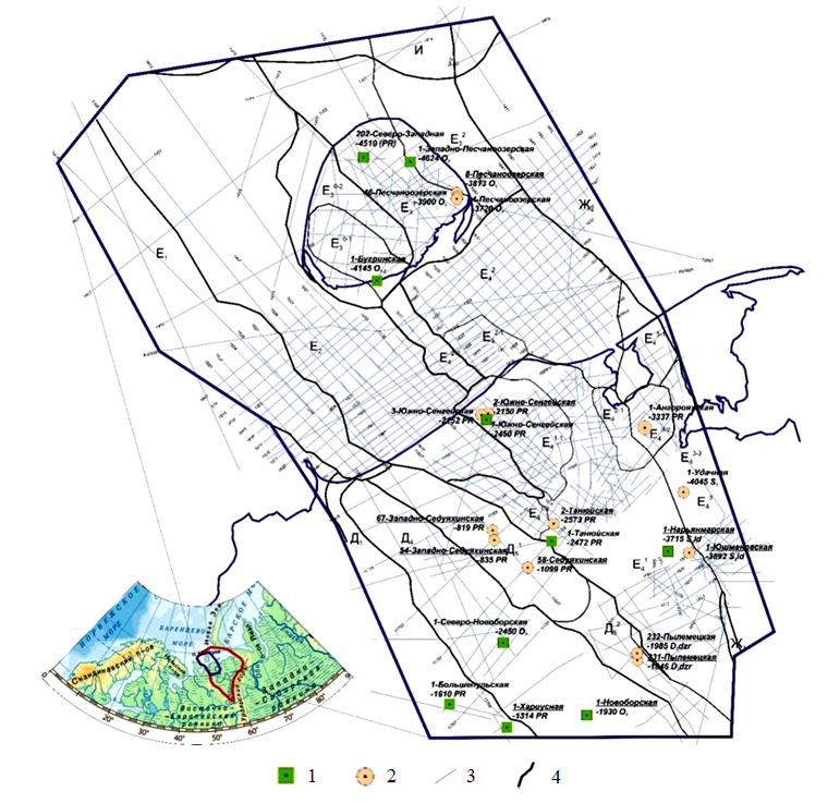
Fig.1. Overview scheme of the investigated area with applied seismic profiles and wells that drilled-in the lower structural floor
Wells: 1 – parametric; 2 – prospecting and appraisal; 3 – seismic profiles CDP-2D;
4 – boundaries of tectonic zoning
More than 5.500 deep oil and gas wells with a drilling volume of more than 10 million meters have been drilled within TPSB. Only 54 of these wells, most of which only drilled-in Mesozoic sediments, were drilled in the aquatorial continuation of the sedimentary basin.
Drilling activity within the land surface of TPSB is very uneven. In the northern half of Izhma-Pechora syneclise, which is the area of this investigation, it does not exceed 0.01 m/km2. In Pechora-Kolvinsky aulacogen located to the east, it increases in some areas up to 200 m/km2. Khoreyver depression of Khoreyver-Pechoromorsk syneclise is characterized by an average drilling activity (50-100 m/km2), but its coastal part is much less studied – drilling activity is only 10 m/km2. Drilling density approaches 50 m/km2 in the water area on the eastern half of Kolguev Island (East Kolguev structural zone). Single wells in other zones provide the total drilling activity of Pechora Sea at a level of 0.01 m/km2 or less. Rock samples in wells were taken in intervals with known or assumed oil and gas saturation, and in parametric (stratigraphic) wells – periodically (pointwise) throughout the wellbore.
The most significant onshore drilling operations were carried out in the period from the 1970s to the early 1990s by the state-owned enterprises “Ukhtaneftegazgeologiya” and “Arkhangelskgeologiya”, and their reorganization – by the enterprises “Lukoil”, “Rosneft”, “Surgutneftegaz”, “Tatneft”, “Gazprom” and other independent establishments. Deep offshore drilling was carried out by
“Arktikmorneftegazrazvedka”.
At different stages of the area investigation, geophysical (mainly seismic) material was repeatedly summarized in thematic works of PGO “Pechorageofizika”, “KOME”, TPO “VNIGRI” (TP “NIC”), FGUE“VNIGRI”, JSC Severgeofizika (authors: F.N.Snisar, N.A.Bogdanov, V.A.Stenina, A.A.Ivanov, T.A.Karpyuk, A.L.Kunko, M.D.Belonin, O.M.Prishchepa, A.N.Shaposhnikova
and others).
Significant contribution to the formation of modern ideas about the geological structure of the region was made by the research works of M.D.Belonin, L.T.Belyakova, V.I.Bogatsky, G.F.Budanov, E.G.Bro, V.A.Dedeev, N.A.Malysheva, A.V.Martynov, N.I.Nikonova, A.V.Kuranova, O.M.Prishchepa, N.I.Timonina and others. Geochemical prerequisites for predicting the oil and gas content of the Timan-Pechora province (TPP) are considered in the works of S.G.Neruchev, T.K.Bazhenova, L.A.Anischenko, S.A.Danilevsky, T.A.Kiryukhina, O.M.Timoshenko, A.V.Stupakova and others.
Potential oil and gas content of the western parts of the region is confirmed by the discovery of Peschanoozersk (1982) and Tarksk (1988) oil fields on Kolguev Island and Verkhne-Kharitseysk (1985) non-industrial field in the Malozemelsko-Kolguevsk oil and gas bearing area (OGBA).
Despite the significant volume of geological exploration (mainly seismic exploration) carried out in recent years within the north-west of Timan-Pechora province, including its offshore continuation, these areas remain underexplored, and if assessing the prospects for oil and gas content, they are high-risk for exploration by enterprises. The reasons for this are negative results of drilling most of the deep wells traditionally constructed within the uplifts on large anticlinal structures, where, according to modern concepts, the section of the lower middle Paleozoic part of the section is significantly reduced.
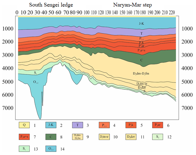
Fig.2. Structure of the sedimentary apron in the operational area
1 – quaternary system; 2 – Jurassic-Cretaceous system; 3 – Triassic system; 4 – Permian system, lower-upper section; 5 – Permian system, lower section, Kungurian stage; 6 – Permian system, lower section, Artinskian stage; 7 – Permian system, lower section, Asselian + Sakmarian stage; 8 – Coal system; 9 – Devonian system, upper section, Domanik horizon – Famennian stage; 10 – Devonian system, upper section, Timan and Sargaevsky horizons; 11 – Devonian system, upper section, Dzhersky horizon; 12 – Silurian system, upper section; 13 – Silurian system, lower section; 14 – Ordovician system, lower-middle sections
Confinement of the discovered oil deposits to Triassic interval of the section determined the increased interest to the upper structural stage and insufficient attention to the lower middle Paleozoic structure. Its prospects are estimated quite high within the territory of the Pechora-Kolvinsk aulacogen adjacent to the investigation area and the central part of the Izhma-Pechora syneclise.
Modern technology for assessing the potential of hydrocarbons (HC) within understudied areas is the technology of modeling the history of sedimentation and transformation (basin modeling). It allows reconstructing the processes of HC generation, migration and accumulation based on the integration of the available geological and geophysical information [4]. Reliability of the received data about the prospects of oil and gas content in the investigated area is determined by the current exploration state.
Both structural and non-anticlinal traps (O.M.Prishchepa, A.V.Kuranov, N.I.Nikonov, S.A.Lukova and others) are considered as predictive objects of oil and gas accumulation
in the sub-Domanic part of the section. Zones of their congestion are of particular interest.
In 2008-2018 the team of FSUE “VNIGRI” has created a scientific and analytical basis for predicting oil and gas accumulation zones in TPP onshore – offshore transition zone. Creation of a model for the formation of oil and gas accumulation zones in the investigated object allows reducing the geological risks and attracting the attention of the operators to the conduction of geological exploration (GE) within the operational area.
Methodology.
Investigation was carried out on the basis of a comprehensive interpretation of geological and geophysical data from regional and areal seismic surveys, the results of drilling and analytical study of the rock samples from the wells, including the Severo-Novoborsk parametric well, drilled by JSC “NPC Nedra” as part of work under a government order.
Following promising oil and gas bearing structures are distinguished bottom-up in the sedimentary apron within the investigated area (Fig.2): Cambrian-(?)lower-middle Ordovician terrigenous, middle Ordovician-lower Devonian carbonate, middle Devonian-lower Frasnian terrigenous, Domanic-Tournaisian carbonate, upper Visean-lower Permian carbonate, upper Permian and Triassic terrigenous [27].
Structural construction of the main reflecting horizons (RH) of the early-middle Paleozoic interval, as well as the analysis of the thicknesses between them, the changes in which are associated with significant tectonic events (Fig.3) were the basis for identifying tectonic elements. Contours of the identified structures are brought in line with the anomalies of the gravitational and magnetic fields. When ranking, the structures were assessed according to the following criteria: sign, shape, isolation, dimension and hierarchy. Dimension and hierarchy determined the order of the structural element and its position in the hierarchical row.
Morphological differentiation of the accumulation surfaces of the lower-middle Paleozoic sediments determined their polyfacies. Sedimentological and lithological-facies analyzes of the investigated interval of the section made it possible to predict the development (vertically and laterally) of rocks with different filtration properties. It gave grounds for contouring the distribution areas of the most promising natural reservoirs in terms of oil and gas content [8]. Perspective oil and gas source strata (OGSS), the presence of which is noted in all sedimentary structures, have been identified and characterized. To assess the possibility of realizing the generation potential of Silurian OGSS, an analysis of the submersion curve was applied. This analysis refers to the methods of paleostructural constructions and reflects the most significant stages of the basin evolution.
Realization degree of the hydrocarbon potential for Silurian OGSS was estimated by the method of basin modeling in TemisFlow software. To build models of migration and the formation of potential hydrocarbon accumulation zones, 2D-models were constructed along the lines selected taking into account changes in the lithological-facies composition of rocks, geochemical indicators, values of formation pressures and temperatures in accordance with the profiles of geological and geophysical sections.
Discussion.
Composition, structure and ratio of rocks that make up natural reservoirs (NR) are determined by genesis – the origin of certain types of sediments, the frequency of sedimentation, the nature of secondary transformations [25, 26]. Genetic approach is an effective technique for predicting the reservoirs as a whole and its individual elements. The most significant structure, which includes a series of NR at different levels, is Domanic-Tournaisian [9]. It also includes Domanic oil and gas generating strata, which is fundamental for the province. Its potential for oil is estimated at 70 % from its contribution to the formation of TPP fields, and for gas – more than 50 %.
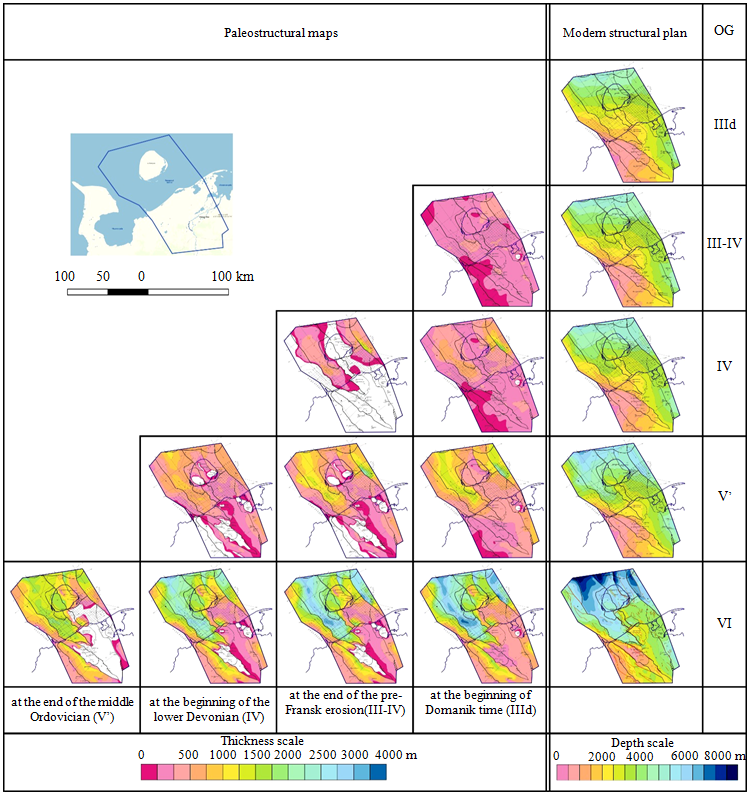
Fig.3. Structural frame of the investigated area (based on seismic survey results)
Main reflective horizons: IIId – sole of Domanik sediments, III-IV – pre-Fransk erosion surface,
IV – near the roof of the Silurian, V’ – near the top of the lower-middle Ordovician terrigenous sediments, VI – foundation roof
Upper Cambrian(?)-lower Ordovician terrigenous oil and gas promising structure is represented in the volume of the upper Cambrian (?) sediments, Sedyel formation of the Tremadocian stage, Nibel formation of the Arenig stage and the conventionally identified Llanvirn stage. Sediments of the structure with angular unconformity lie on the base of the Proterozoic age and are represented by sandy-clay sediments of the littoral and supralittoral. Structure is spread in the paleo-depressions of the Sozvinsk-Novoborsk structural zone and the water area of the West Kolguevsk depression. Characteristic feature of the sedimentation conditions is the compensated filling of the basin, which was ensured by the removal of clastic material from Timan and the uplifted Malozemelskiy block. Well 202-Severo-Zapadnaya (Kolguev Island) drilled-in the structure to the fullest extent, where the upper Cambrian age of the silty-argillaceous stratum at a depth of 4147-4345 m has been proven by faunal evidence. Overlying Sedyel (Sediol) formation, composed mainly by sandy material, is dated to Tremadocian stage of the lower Ordovician. 1-Bugrinsk well drilled-in thick (not less than 1000 m) Tremadoca sediments, represented by rhythmic interbedding of sandstones and mudstones with a clear predominance of sandstones. In the southern part of the investigated area – within
Izhma-Pechora syneclise – sediments of the same age were drilled-in by 1-Bolshepulskaya well, where their thickness is about 50 m.
Middle Ordovician-lower Devonian carbonate OGS is distinguished in the volume of the upper part of the middle-upper Ordovician, Silurian and lower Devonian, it is distributed in a limited part of the investigated area.
Silurian sediments within the operation area were exposed only on the Malozemelsko-Kolguevsk monocline, predominantly with a carbonate composition and a total thickness of 0-500 m. Lower and upper sections are distinguished within the Silurian system.
Lower Silurian section in the volume of the Llandoverian and Venlokian stages, composed of interlayered red mudstones, siltstones, sandstones, was studied by wells 1-Yuzhno-Sengeiskaya and 1-Tanyuiskaya.
Upper Silurian section in the volume of Ludlovian and Przhidolian stages within the investigated area has a limited distribution because of prolonged pre-middle Devonian and pre-Fransk erosions. Corresponding section was drilled-in by wells in the structures of Malozemelsk block (1-Yuzhno-Sengei, 1-Yushmanovsk, 1-Naryan-Mar).
Upper deposits of the lower Devonian are represented by fragmentarily developed deposits of the Lokhkovian stage, presumably in the volume of the Ovinparmian horizon only in the extreme eastern sections of the investigated area. Its presence in the section was proved by drilling data at the Peschanoozersk area in wells 4 (thickness is 46 m) and 46 (256 m). Rocks are represented by carbonate-argillaceous and sulfate-carbonate-argillaceous deposits of lagoons in the West Kolguevsk depression and Peschanomorsk structural zone.
Table 1
Reservoir characteristics of the main lithological types of shallow-water shelf genesis of the upper Devonian
carbonate structure [21]
|
Facial zones |
Rocks types |
Reservoir type |
Porosity |
Fissured |
Permeability |
|
|
Shallow-water shelf |
Silt hills |
Patterned spheral-clotted limestones |
Fissure-pored |
2.3-5.25 |
0.9-2.6 |
0.072-3.36 |
|
Patterned |
Pore-fissured |
1.34-3.17 |
1.5-3.7 |
< 0.001 |
||
|
Secondary dolomites |
Fissure-cavernous-pored |
1.41-12.0 |
1.2-3.5 |
0.037-6.6 |
||
|
Morphological bottom uplifts |
Detrital limestones |
Pored |
0.3-11.0 |
1.7-2.8 |
0.6-222 |
|
|
Open shallow-water shelf |
Uneven-grained spotted |
Pore-fissured |
0.6-4.18 |
1.5-2.3 |
< 0.01 |
|
|
Thin fine-grained limestones |
Pore-fissured |
0.4-10 |
1.3-2.1 |
< 0.001 |
||
|
Facies of a shelf shallow with complicated water exchange |
Primary dolomites |
Pore-fissured |
2.8-4.7 |
0.5-1.2 |
< 0.01 |
|
|
Anhydrites |
|
0 |
|
0 |
||
Domanik-Tournaisian carbonate OGS in the volume from the Domanik horizon of the upper Devonian to the Tournaisian sediments of the lower Carbon is vastly developed and is represented in the most part of the TPSB by terrigenous-carbonate rocks. Three sublatitudinal lithological-facies zones can be distinguished according to the features of the sediments composing the structure: southern – coastal-marine and trans-reef shelf with terrigenous and carbonate sediments; central – slope progradational terrigenous-carbonate sedimentation with single linearly grouped reefs; northern – with condensed siliceous-carbonate rocks (domanikites) of the pre-reef depression and wedgeouts of the terrigenous-carbonate filling strata. General tendency for this OGS is an increase in terrigenous material to the west. Within the investigated area, southern distribution zone corresponds to the southern part of the Malozemelsko-Kolguevsk monocline, up to the latitude of Kolguev Island; central – Kolguev Island and to the west; northern – north of Kolguev Island. Thickness of the OGS varies from 250-300 to 400-600 m due to the presence of reef structures in the central part and decreases in the northern zone. Amplitude of pre-Visean erosion increases to the west, destroying ancient layers of the structure, up to the swing included [7, 13].
Distribution patterns of reservoir rocks (table 1) and seals forming PR of various scales were revealed on the basis of the comprehensive interpretation of geological and geophysical data within each OGS.
Results.
Natural geological bodies of the formation level, where the processes of oil and gas formation took place (and / or are proceeding) – oil and gas source formations or horizons, are responsible for the oil and gas potential of various regions. Total oil and gas source potential of a particular oil and gas basin (OGB) should be assessed by the amount of organic substance (OS) contained in the OGSS. It is characterized by certain OS concentrations, types and volumes, i.e. thickness and area of development, as well as maturity (catagenesis). In order for OGSS (or their combination) to turn into an oil and gas formation cluster (OGFC), minimum values of HC migration densities from them must be at least 50 thousand tons/km2 (50 million nm3/km2) under ideal conditions of accumulation (in the immediate vicinity of the reservoir and its optimal thickness).
In the general case, the value of 100 thousand tons/km2 (100 million nm3/km2) can be taken as the boundary cluster density of migration [18]. In order to mark the localization of OGFC, first it is necessary to determine the area of development and the thickness of OGSS, as well as the concentration of OS (Corg) in them. Then the degree of OS catagenesis should be identified, and after that, using the created models of HC generation-migration, the scale of OS type migration for the corresponding given OGSS should be calculated.
There is very little data from geochemical investigations of fluids and rock sample extracts at the investigated area, which could make it possible to get an idea of the generation potential. Detailed geochemical study of rock samples from wells 202-North-West, 1-Aquamarinsk and 2-Aquamarinsk revealed the main geochemical characteristics of potential oil and gas source rocks in the operation area and the main regularities of OS transformation processes.
Entire sedimentary section is characterized by a low content of bitumoids, whereas oxidized components prevail in Permian-Triassic rocks, and reduced components in most samples of Paleozoic rocks [1, 2, 18, 24].
Content of soluble components in the composition of dispersed organic substance (DOS) is rather heterogeneous and irregularly varies over a wide range (1.4-17.5 %). This may be due to a change in the conditions of sedimentation and / or the source of sedimentation material drift. Bitumoids in the investigated samples have a syngenetic nature.
Mudstones of the lower Ordovician (O1t) and upper Cambrian (Є3?) are characterized by shallow water-sea conditions of formation and sapropel OS. At the same time, Ordovician samples contain a large proportion of algal OS (table 2). Degree of rock transformation according to bituminological data remains relatively low; however, the correctness of these definitions is questionable, especially given the small amount of available rock sample material [14].
Table 2
Results of rock samples investigation for well 1-Bugrinsk by the Rock-Evalmethod
|
Sample |
Depth, m |
S1 |
S2 |
Tmax |
TOC |
HI |
PI |
|
|
1 |
4086.00 |
0.01 |
0.04 |
439 |
0.08 |
˗ |
˗ |
|
|
2 |
4149.83 |
0 |
0.02 |
439 |
0.08 |
˗ |
˗ |
|
|
3 |
4153.00 |
0 |
0 |
w/o |
0 |
˗ |
˗ |
|
Note. S1 – free HC to 300 °С, mg HC/g of rock; S2 – HC-products of kerogen and resinous-asphaltene substances pyrolysis at 300-600 °С, mg HC/g of rock; Tmax – temperature of the maximum HC output during kerogen pyrolysis, °С; TOC – total content of organic carbon in the rock, % mass; HI – hydrogen index, mg HC/g TOC; PI – productivity index S1/(S1 + S2).
Within the Malozemelsko-Kolguevsk monocline (MKM) and adjacent territories, Silurian strata can be considered as oil source strata, distinguished in the well sections by positive anomalies of the gamma-ray log curve.
Zone of distribution for the Silurian OGSS is the submerged parts of the Shapkinsk step, as well as the depocentral parts of West Kolguev depression and the Denisov block in the junction zone of MKM. There, under the conditions of marine paleo-bays, significantly clay strata, rich in aquagenic OS and possessing oil source potential, were formed.
According to the geochemical characteristics, upper Devonian mudstones of the Famennian and Frasnian stages, which include Domanic rocks, considered as the main oil source depression deposits in the regional plan [21], have shallow-marine genesis within MKM. In addition, these rocks are characterized by a low level of thermal maturity. According to the data of detailed bituminology, it can be evaluated as MK1; however, taking into account the entire amount of material, this value should be considered rather underestimated. In some samples, there is an increased content of Corg, as well as a significant proportion of algal OS [23].
Marls of the upper Carbon in their geochemical characteristics are close to the rocks of Permian age, but differ in deeper-water conditions of DOS sedimentation and processing. In the carbonate rocks of the middle and lower Carbon OS becomes predominantly sapropelic whereas maintaining a relatively low level of catagenetic transformation and insignificant variations in facies conditions of sedimentation.
Influence of humus material is rather reduced in the rocks of the middle and lower Permian, and the facies conditions of sedimentation can be characterized as lagoon-continental. Thermal maturity is low.
Lower and middle Triassic rocks are characterized by mixed humus-sapropel DOS. Diagenetic transformation of the initial DOS took place in a shallow-water marine facies setting. Thermal maturity of DOS is low [22].
Thus, DOS of the investigated samples can be estimated as thermally weakly-moderately transformed, sapropelic-humus (Perm-Triassic) and humus-sapropel (Carbon-Cambrian?).
The main role in terms of oil and gas formation on TPSB territory belongs to Domanik-Tournaisian (D3dm-C1t) and Silurian formations (29 and 25 % for oil, respectively) [18], lower Permian formations are less significant (12 for oil and 22 % for gas).
Domanik-Tournaisian D3dm-C1t formation continues from the continent into the sea based on facies constructions and seismic data, results of which were used to identify reef bodies that outline the zone of pre-reef facies of sublatitudinal strike. There are thin layers of domanic rocks in the section of clay-carbonate deposits of the 1-Pakhancheskaya well, which is typical for some areas of the back reef facies near the reef body itself. These seams are enriched by OS and are insignificant in terms of large-scale oil and gas formation, but indicate the relative proximity of the formation-scale Domanikoids. Thickness of the Domanic OGSS increases from west to east – from 20 to 300 m as the age range of the formation expands [13, 15]. Average Corg concentrations vary in the range of 0.6-1.5 %, Domanik-Tournaisian OGSS is characterized by the following degrees of OS catagenesis in the area of operations: $MK^{1}_2$ and $MK^{2}_2$.
OGSS of the Artinsk-Kungur structure P1ar-P1k within the water area improves its oil and gas source properties due to an increase in the maturity of OS (catagenesis) as a result of a significant increase in the thickness of Triassic sediments. OGSS of the Artinsk formation has a clay-carbonate composition. There, OS is represented by the following types: sapropelites, oxy-sorbosapropelites, and also humites. OGSS composition of the Kungur formation is predominantly terrigenous (mudstones and clayey siltstones), with the following OS common types: humite-sapropelite and sapropelite-humite.
Lower Permian sediments of the Artinskian and Kungurian stages are characterized by a rather high oil generation potential. However, in terms of the transformation degree, they are at the upper boundary of the oil window, i.e. in the early stages of catagenesis. Consequently, modeling results should show in which parts of the investigated area the transformation degree of the lower Permian deposits was high enough for the formation of industrial HC deposits [10].
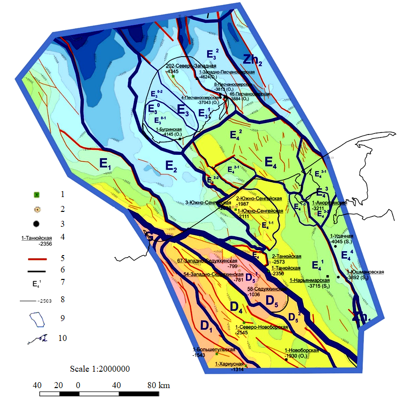
Fig.4. Structural map for the base (OG VI) with tectonic zoning
Tectonic elements: Superorder: G – Timan ridge; D – Izhma-Pechora syneclise; Е – Malozemelsko-Kolguevsk megablock (monocline); Zh – Pechora-Kolvinsk megablock (aulacogen); I – North Pechoromorsk monocline; 1order: D1 – Neritsk step; D4 – Novoborsko-Sozvinsk structural zone; D5 – Seduyakhinsko-Malolebedinsk disjunctive megaswell; Е1 – Korginsk step; Е2 – West Kolguevsk depression; Е3 – Kolguevsk block; Е4 – Malozemelsk block; Zh1 – Pechora-Kozhvinsk graben; Zh2 – Denisovsk block; 2 order: $D^1_5$ – Seduyakhinsk disjunctive swell; $D^2_5$ – Seduyakhinsko-Yantygsk bridge; $E^0_3$ – West Kolguevsk uplift; $E^1_3$ – Kolguevsk structural zone of horsts and grabens; $E^2_3$ – Peschanomorsk structural zone; $E^1_4$ – Naryan-Mar step; $E^2_4$ – Udachnaya step; $E_3^4$ – Haritseisko-Shapkinsk step; 3 order: $E^{0-1}_3$ – Bugrinsk dome; $E^{0-2}_3$ – West Bugrinsk step; $E^{1-1}_4$ – South Sengei dome; $E^{1-2}_4$ – East Seduyakhinsk ledge;
$E^{1-3}_4$ – Nerut graben; $E^{2-1}_4$ – Sengei graben; $E^{2-2}_4$ – Sengei horst; $E^{3-1}_4$ – Haritsei step; $E^{3-2}_4$ – South Anorgayakhsk dome
Wells: 1 – parametric; 2 – appraisal; 3 – that didn’t drilled-in the base; 4 – name of the well, bottomhole depth; 5 – ridges; 6 – boundary of tectonic elements;7 – name of the tectonic element; 8 – isohypses; 9 – investigation area; 10 – coastline
In the northwestern part of TPP, Artinsko-Kungursk OGSS is characterized by the degrees of OS catagenesis МК1 and $MK^{1}_2$.
In order to assess the scale of oil and gas formation within any territory (water area) with the use of existing computational models, it is necessary: to select OGSS; to determine the area of their distribution and thickness, i.e. volume; concentration and type of organic substance in the rocks composing them; degree of OS catagenesis.
The most known oil and gas source formations within MKM and adjacent territories have significant differences due to different conditions of sedimentation and distribution in the section of DOS-enriched rocks.
Fig.5. Model of paleotectonic development of the basin in the area of the Naryan-Mar and Kharitsei-Shapkinsk steps
(well 1-Yushmanovsk)
Submersionchartsfor: 1 – base; 2 – boundaries of sedimentary structures; 3 – sea level change curve
Results of the work carried out to assess the oil and gas source potential in the lower middle Paleozoic section of MKM showed the main prospects for the formation of possible hydrocarbon accumulations to be associated with the Silurian oil and gas fields. It was not possible to separate lower and upper Silurian sediments in the investigated area, therefore, the characteristics of their oil and gas source potential are given together.
To the west of the fault that separates the structures of the Pechora-Kolvinsk aulacogen from the Malozemelsko-Kolguevsk monocline, a strip of OGSS absence is mapped. Thickness scale for OGSS of the Silurian structure in the area of operations is 50-400 m, whereas the direction of change in the thickness and their gradients are brought in accordance with the seismic map of the total thicknesses O2-D1. Average Corg concentrations in OGSS (S1-2) vary in the range 0.25-0.60 % [3, 18].
Data of analytical geochemical investigations provided the basis for creating a basin model for the studied region. Modeling of the generation processes, migration and accumulation of hydrocarbons was carried out using the TemisFlow software. Geological history of the basin is modeled by means of Backstripping technology, which involves the restoration of the basin submersion history by successive cutting of structural horizons. Modeling of geochemical history is carried out on the basis of the kinetic model of hydrocarbon transformation, based on the work of the French Institute of Petroleum (IFP). Applied modeling method allows combining disparate geochemical and structural materials, assessing the qualitative characteristics of oil and gas source rocks and the realization degree of their potential, obtaining approximate, but substantiated quantitative data on the scale of HC generation and migration.
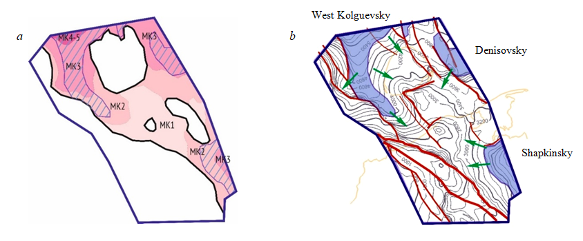
Fig.6. Catagenetic zoning of the upper Silurian sediments (a), generation clusters and directions
of HC migration in the Malozemelsko-Kolguevskaya monocline and zones of its junction
with adjacent territories (b)
At the initial stage, structural maps were built for the main reflecting horizons and thickness maps between them in order to create a model (Fig.3, 4). Degree of erosion was estimated as a result of large interruptions in sedimentation. Promising source strata and predicted reservoirs and seals of the lower structural stage of the MKM were identified [32].
At the initial stage of the work, the catagenetic transformation of OS was also estimated by the deep drilling data using 1D modeling method (Fig.5). Modeling of the temperature history of catagenetic changes in rocks is based on the expert opinion of T.K. Bazhenova, who believes that there was a reduced catagenetic zoning in the Paleozoic basins. It was caused by increased paleo-gradient of temperatures – up to 4.5-5.0 °С/100 m, as well as data on the modern thermal gradient for mobile base blocks (which was MKM) 2.4-2.7 °С/100 m.
To assess the reliability of seals and the generation potential of oil source rocks, the analysis results of logging data from deep wells, extrapolated to the territory of the entire area, were used. Surfaces of seals and oil source rocks were calculated by the method of convergence in the interval between the main structural horizons by proportional division of the stratum between the main deep surfaces. Correction of depth reference was made according to well data in areas where it is possible. To assess erosion, it was assumed that the maximum apparent thickness of the eroded structure is practically equal to the thickness of the structure before erosion. After that, amount of erosion was calculated as the difference between the maximum thickness and the current thickness. In this case, paleorelief at the time of the analyzed structure formation was taken into account. Filling thickness of the paleodepressions was excluded from the calculation, for which the correlation of additional horizons was performed [17].
Data were input into the TemisFlow software in the corresponding formats, and additional parameters were set for calculating the basin model, obtained from the analysis of geological and geochemical maps and tables. Thus, data on lithology, OS type and sedimentation conditions were input (see Fig.2).
Based on the preparatory work, it was revealed that the organic substance in the Silurian OGSS in the operation area is characterized by the catagenesis degree from MK2 to MK3, only on the extreme northern periphery – to MK4-5. The main generation clusters are shown in Fig.6.
Identification and substantiation of oil source strata in the modeling process was a difficult task due to the marginal position of the operation area in the oil and gas basin. Belonging to a reservoir, seal or oil source stratum was determined based on the lithological characteristics of the stratum and the Corg content. Members in the upper Silurian and upper Devonian Domanik sediments were investigated as OGSS.
Upper Silurian sediments in the operation area represent a stratum of argillaceous-carbonate interbedding, which was studied in natural outcroppings along the river Dolgaya. Analysis of the GL curve for well 1-Naryan-Marskaya made it possible to take the thickness of interlayers with oil source potential as 1/3 of the total thickness for upper Silurian sediments.
Lower Devonian sediments are developed locally and are not widespread. Their development is associated with the most submerged areas of the pre-Timan structural stage.
Sediments of the upper Devonian Domanik horizon are characterized by lithological-facies variability. In the southeastern part of the operation area, sediments of Domanik horizon are represented mainly by clay-carbonate rocks, and in the northern part, mainly carbonate. Thus, a clay-carbonate member is identified near the base of the Domanik sediments, which wedges out in a northeastern direction [11, 31]. To characterize organic substance, wells and outcroppings were
selected in the operation area and in adjacent territories (Table 3).
Table 3
Characteristics oforganic substance
|
Area |
Number of well/sample |
Depth, m |
Age |
Value of Corg, % |
|
Yuzhno-Shapkinsk |
26 |
3886 |
D3sr+kn |
0.95 |
|
3963 |
D3sr+kn |
1.09 |
||
|
3885 |
D3kn |
0.23 |
||
|
3783 |
D3dm |
3.6 |
||
|
3786 |
D3 |
4 |
||
|
Naryan-Mar |
10702 |
natural outcroppings |
S2 |
1.3 |
|
10700 |
natural outcroppings |
S2 |
2.28 |
|
|
10700 |
natural outcroppings |
S2 |
2.87 |
Type of kerogen was determined based on the results of analysis for rock samples from well 26-Yuzhno-Shapkinsk by the Rock-Eval method (and also based on the kinetic conditions of generation): age D3dm; Tmax 446 °C; S1 1280; S2 7910; HI 220.
Calculation of the HC migration scale [20] is carried out according to the following formulas:
for oil
where Qoil – oil migration density, t/km2; δ – correction for volatile liquids HCС7-С14 (calculated during simulation); Сcon – average concentration for OGSS, % to rock; r – rock density, t/m3; h – OGSS thickness, m; $\beta_{c_{con^{r}}}^{BIT}$ – residual OS bituminization, % toСcon (calculated during simulation or averaged over actual data); K – coefficient of liquid HC migration, units;
for gas
where Qg – gas migration (generation) density, nm3/km2; γg – proportion of HC gases generated (migrated) by the middle of a given gradation of catagenesis, reduced to the OS of this gradation, is calculated during modeling, %; Сg – proportion of carbon in insoluble OS, averaged for a given grade and type of OS, %.
Scale of HC migration is the primary basis for assessing the prospects of a particular region, then the quantitative assessment of HC resources is determined by the conditions of their accumulation and preservation.
Timan-Sargaevsk sediments of the upper Devonian, Kungurian sediments of the lower Permian, as well as the sediments of the middle upper Permian are taken as seals. In addition, clay members in lower middle Devonian, Carbon, and Artinskian sediments of the lower Permian act as local seals. However, their thickness is insignificant, therefore, when constructing this model, they can be neglected [28, 30, 31, 33].
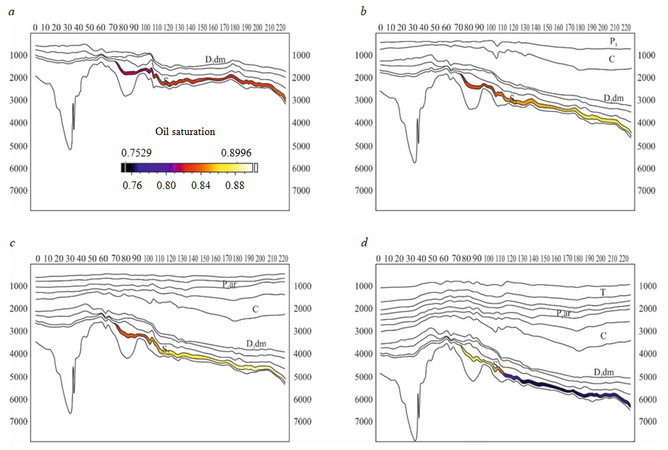
Fig.7. Generation scale of liquid hydrocarbons at stratigraphic levels: а – Devonian Carbon (358.9 million years ago);
b – early Permian (290.1 million years ago); c – Triassic (252.2 million years ago); d – modern time
Results for modeling of HC generation and redistribution are clearly presented by the schemes of the distribution for the density of the HC liquid phase at different stages of geological history (Fig.7).
Total generated mass of HC substance, according to the constructed model, within the operation area is 3.17 billion tonns o.e. This value reflects HC mass generated only by the area own oil source strata, and does not take into account HC that could migrate from the outside, from the
Pechora-Kolvinsk aulacogen (Pechora-Kozhvinsk megaswell). Based on the simulation results, expected phase composition of the generated HC is predominantly oil. According to S.G.Neruchev and S.V.Smirnov [16], “total path migration oil losses during vertical and then lateral migration in different geological conditions can vary significantly, usually amounting to at least 55-60 %, which is probably extremely rare; can reach 80-95 %, which occurs most often in natural conditions, and can reach 100 %, and then industrial oil deposits cannot form, although oil formation took place”.
Obviously, volumes of HC accumulation are much lower and are determined by the paths of HC migration, volumes and properties of traps along these paths (including the permeability and porosity characteristics of reservoirs and the fluid-tight properties of the seals).
Middle Devonian – lower Frasnian terrigenous and middle Ordvik – lower Devonian carbonate structures are the most promising from the point of view of oil and gas potential. Section of the structures is characterized by the presence of a good reservoir potential, shut by the zonal lower Devonian and regional Timan-Sargaevsk seals. It is assumed that the main oil and gas prospects of middle Ordvik – lower Devonian structures are connected with a zone of stratigraphic wedging out, overlapped by the Timan-Sargaevsk regional seal. If the Silurian carbonate sediments are overlapped by Dzher terrigenous sediments, they can represent a single hydrodynamically connected structure under lower Middle Frasnian seal.
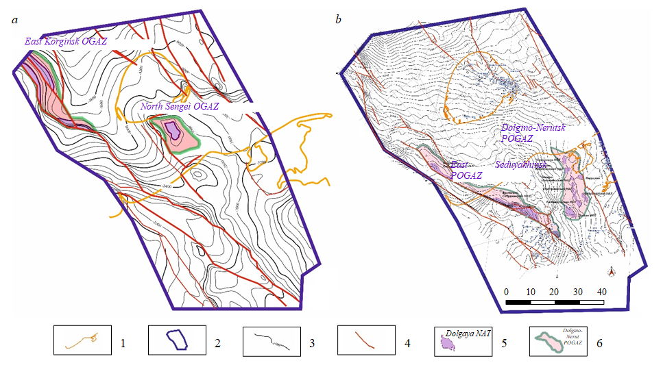
Fig.8. Location of promising oil and gas accumulation zones: а – middle Ordovician – lower Devonian,
b – middle Devonian – lower Frasnian OGS
1 – coastline; 2 – investigated area boundary; 3 – isohypses of Silurian roof (a) and the sole of Timan-Sargaevsk interval (b);
4 –tectonic disturbances; 5-6 – promising oil prospecting sites: 5 – traps; 6 – promising oil and gas accumulation zones
Main prospects for identifying HC accumulations are associated with traps, mainly of the structural-tectonic type and stratigraphic wedging out on the western slope of the West-Kolguev depression, within the Sengei uplift, in the zones of junction of the Naryan-Mar stage with Nerut graben and Seduyakhinsk swell (Fig.8) [12]. Localized HC traps are combined into promising oil and gas accumulation zones (POGAZ).
Conclusion.
Based on the results interpretation of the seismic surveys carried out in the northwestern part of the TPP, including its water area, generalization of the deep drilling results (including Severo-Novoborsk parametric well), structural maps and thickness maps of all seismic facies structures developed in the territory and in the water area were significantly refined. They were used in basin modeling by TemisFlow software in order to reconstruct the submersion and transformation conditions of OS in potential oil and gas bearing formations, the most promising of which seems to be Silurian OGSS. According to the created basin model, total mass of HC substance generated only by the own oil and gas fields in the operation area is 3.17 billion tonns o.e.
Modeling made it possible to get an idea of the time and conditions for the formation of large zones of possible HC accumulation. The zones of HC paleoaccumulation are predicted on the basis of their space-time relationships with possible generation clusters, comparison with the periods of intense HC generation both from within the operation area and outside (taking into account possible migration). One of the unresolved issues is the search for transit paths of HC migration from the cluster of oil and gas formation located in the water area and the cluster of HC generation located within the Pechora-Kozhvinsk megaswell.
Conducted investigations made it possible to identify POGAZ spatially confined to the western slope of the West Kolguev depression, Sengei ledge, junction zones of Naryan-Mar step with Nerut graben and Seduyakhinsk swell. These POGAZ are considered as priority exploration targets for HC deposits prospecting in middle Ordovician – lower Devonian and middle Devonian – lower Fransky oil and gas structures [29]. The most important geological feature of these structures
development is the formation of extended traps of a stratigraphic type (sometimes with tectonic shielding), which gives hope for the formation of large accumulation zones of hydrocarbons located in the frontal part of the migration flow from submerged areas of the region.
References
- Averyanova O.Yu., Morariu D. Estimation variability of the hydrocarbon potential of oil and gas systems. Neftegazovaya geologiya. Teoriya i praktika. 2016. Vol. 11. N 3, p. 1-22. DOI: 10.17353/2070-5379/32_2016 (in Russian).
- Astakhov S.M. Refinement of the vitrinite maturation model in the dislocated areas. Geologiya nefti i gaza. 2014. N 3, p. 64-74 (in Russian).
- Bazhenova T.K. Oil and gas source formations of ancient platforms of Russia and oil and gas potential. Neftegazovaya geologiya. Teoriya i praktika. 2016. Vol. 11. N 4, p. 1. DOI: 10.17353/2070-5379/45_2016 (in Russian).
- Bogoslovskii S.A. Modeling the processes of oil and gas formation in Korotaikhinsk depression using Temis 3D. Resursno-geologicheskie i metodicheskie aspekty osvoeniya neftegazonosnykh basseinov: Sbornik materialov II Mezhdunarodnoi konferentsii molodykh uchenykh i spetsialistov. St. Petersburg: VNIGRI, 2011, p. 142-146 (in Russian).
- Garetskii R.G. Tectonics and geodynamics of the northeastern and southwestern margins of the East European craton and adjacent areas of young plates. Neft, gaz Arktiki: Materialy mezhdunarodnoi nauchno-tekhnicheskoi konferentsii. Мoscow: Interkontakt Nauka, 2007, p. 42-49 (in Russian).
- Deulin Yu.V. Conodonts and correlation of oil productive upper Devonian sediments in the north of the Timan-Pechora province. Arkhangelsk: Geologicheskii institut Rossiiskoi akademii nauk, 2006, p. 253 (in Russian).
- Kiryukhina T.A., Fadeeva N.P., Stupakova A.V. et al. Domanik sediments of Timan-Pechora and Volga-Ural basins. Geologiya nefti i gaza. 2013. N 3, p. 76-87 (in Russian).
- Egorov A.S. Features of the deep structure and material composition of the geostructures in the earth crust of the continental part in the territory of Russia. Journal of Mining Institute. 2015. Vol. 216, p. 13-30 (in Russian).
- Alekseev A.D., Zhukov V.V., Strizhnev K.V., Cherevko S.A. Study of hard-to-recover and unconventional objects according to the principle of “reservoir factory in the formation”. Journal of Mining Institute. 2017. Vol. 228. p. 695-704. DOI: 10.25515/PMI.2017.6.695 (in Russian)
- Kontorovich A.E., Burshtein L.M., Malyshev N.A. et al. Historical and geological modeling of naphthydogenesis processes in Mesozoic-Cenozoic sedimentary basin of the Kara Sea. Geologiya i geofizika. Spetsialnyi vypusk. 2013. Vol. 54. N 8, p. 1179-1226 (in Russian).
- Kochneva O.E., Nefedov Yu.V., Fedorov, N.V. Establishing the relationship between reservoir properties and facies features of the Bashkir sediments of the Gagarinsk field. Neftyanoe khozyaistvo. 2019. N 2, p. 24-27. DOI: 10.24887/0028-2448-2019-2-24-27 (in Russian)
- Kulpin L.G., Savchenko V.P., Obmorosheva L.B. Shallow bays of the arctic seas: features of the development of hydrocar-bon resources. Oil&Gas Journal Russia, 2011. N 5, p. 22-27 (in Russian).
- Kiryukhina T.A., Bolshakova M.A., Stupakova A.V. et al. Lithological and geochemical characteristics of Domanik sedi-ments in the Timan-Pechora basin. Georesursy. 2015. Vol. 61. N 2, p. 87-100. DOI: 10.18599/grs.61.2.8 (in Russian).
- Lukova S.A. Pechora-Kolvinsk aulacogen (onshore, Pechomorsk shelf): history of formation and forecast of the distribution of oil and gas accumulation zones in sub-Domanic deposits. Geologiya, geofizika i razrabotka neftyanykh i gazovykh mestorozhdenii. 2014. N 2, p. 10-19 (in Russian).
- Sannikova I.A., Bolshakova M.A., Stupakova A.V. et al. Modeling the generation scale of the hydrocarbon fluids in the Domanik oil source stratum of the Timan-Pechora basin using various kinetic spectra of organic substance destruction. Georesursy. 2017. Vol. 1, p. 65-79. DOI: 10.18599/grs.19.8 (in Russian).
- Neruchev S.G., Smirnov S.V. Assessment of potential hydrocarbon resources based on modeling the processes of their generation and formation of oil and gas fields. Neftegazovaya geologiya. Teoriya i praktika. 2007. Vol. 2, p. 1-34.
- Obmetko V.V. Prospects for oil and gas content of the aquatorial part of the Pechora-Kolvinsk aulacogen. Avtoref. dis. ... kand. tekhn. nauk. Мoscow: Institut geologii i razrabotki goryuchikh iskopaemykh, 2007, p. 25 (in Russian).
- Bazhenova T.K., Vasileva V.F., Klimova L.I. et al. Organic geochemistry of Timan-Pechora basin. St. Petersburg: VNIGRI, 2008, p. 162 (in Russian).
- Pokrovskii S.P., Gots I.A., Sambuev B.S., Viskunova K.G. Features of the methodology for conducting seismic CDP oper-ations in the transit zones of the Russian Federation (on the example of the north of Timan-Pechora province). Tezisy dokladov mezhdunarodnoi nauchno-prakticheskoi konferentsii “Geomodel 2008”, sentyabr, 2008, Gelendzhik. EarthDoc, 2008 (in Russian). DOI: 10.3997/2214-4609.201404441
- Neruchev S.G., Bazhenova T.K., Smirnov S.V. et al. Assessment of potential hydrocarbon resources based on modeling of their generation, migration and accumulation. St. Petersburg: Nedra, 2006, p. 363 (in Russian).
- Parmuzina L.V. Upper Devonian structure of Timan-Pechora province (structure, formation conditions, patterns of reservoir location and oil and gas content). St. Petersburg: Nedra, 2007, p. 151 (in Russian).
- Repin Yu.S., Fedorova A.A., Bystrova V.V. et al. Mesozoic of Barents sea sedimentary basin / Yu.S. Repin, A.A. Fedorova, V.V. Bystrova et al. // Stratigraphy and its role in the development of the oil and gas industry of Russia. St. Petersburg: VNIGRI, 2007, p. 112-162 (in Russian).
- Sannikova I.A., Kiryukhina T.A., Bolshakova M.A. Generation potential of Domanik sediments in the southern part of Timan-Pechora oil and gas basin. Geologiya v razvivayushchemsya mire: materialy VIII nauchno-prakticheskoi konferentsii studentov, aspirantov i molodykh uchenykh s mezhdunarodnym uchastiem, 23-26 aprelya, 2015, Perm, Rossiya. Vol. 1. Permskii gosudarstvennyi natsionalnyi issledovatelskii universitet, 2015, p. 498-502 (in Russian).
- Sitar K.A. Geological and geochemical conditions for the formation of oil and gas content in the northern (aquatorial) part of Timan-Pechora basin. Avtoref. dis. ... kand. tekhn. nauk. Мoscow: Moskovskii gosudarstvennyi universitet im. M.V.Lomonosova, 2007, p. 24 (in Russian).
- Stupakova A.V. Timan-Pechora basin. Structure and main stages of development. Georesources. 2017. Spetsialnyi vypusk. Ch. 1, p. 56-64 (in Russian).
- Belyakova L.T., Bogatskii V.I., Bogdanov B.P. et al. Base of Timan-Pechora oil and gas basin. Kirov: OAO “Kirovskaya oblastnaya tipografiya”, 2008, p. 288 (in Russian).
- Basov V.A., Vasilenko L.V., Viskunova K.G. et al. Evolution of sedimentation environments of the Barents-North Kara paleobasin in the Phanerozoic. Neftegazovaya geologiya. Teoriya i praktika: elektronnyi vypusk. 2009 (4). N 1 (in Russian).
- Ayrapetyan M.G., Farukshin A.A., Blinkova E.Y. The Method of Correlation of the Pashisky Horizon Deposits in the Cen-tral Part of the Orenburg Region Based on the Combined Selection of Electrometric Facies and Lithotypes of Rocks. Conference Pro-ceedings, Geomodel, 7-11 September, 2020, Gelendzhik, Russia. EarthDoc, 2020. Vol. 2020, p. 1-5. DOI: 10.3997/2214-4609.202050059
- Cherepovitsyn A., Metkin D., Gladilin A. An algorithm of management decision-making regarding the feasibility of investing in geological studies of forecasted hydrocarbon resources. Resources. 2018. Vol. 7. Iss. 3, p. 1-17. DOI: 10.3390/resources7030047
- Farukshin A.A., Ayrapetyan M.G., Zharkov A.M. The Geological Uncertainties Evaluation Features of Late Stage Devel-opment Deposits in Lower Cretaceous Oil and Gas Bearing Formations of Western Siberia. Conference Proceedings, Geomodel, 7-11 September, 2020, Gelendzhik, Russia. EarthDoc, 2020, p. 1-5. DOI: 10.3997/2214-4609.202050066
- Mardashov D., Islamov S., Nefedov Y. Specifics of well killing technology during well service operation in complicated conditions. [Detalhes da tecnologia de controle de poço durante a operação em condições complicadas]. Periodico Tche Quimica, 2020. Vol. 17. Iss. 34, p. 782-792.
- Prischepa O.M., Bogatskiy V.I., Grigorenko T.I. et al. Northwestern Timan-Pechora basin – new insights into petroleum potential prospects. Neftegazovaya geologiya. Teoriya I praktika. 2014. Vol. 9. Iss. 3, p. 1-6. DOI: 10.17353/2070-5379/41_2014
- Palyanitsina A., Sukhikh A. Peculiarities of assessing the reservoir properties of clayish reservoirs depending on the water of reservoir pressure maintenance system properties. Journal of Applied Engineering Science. 2020. Vol. 18 (1), p. 10-14. DOI: 10.5937/jaes18-24544