Biostratigraphy of the Middle Paleozoic of Guinea
Abstract
Middle Paleozoic sediments are widespread in the territory of the People's Revolutionary Republic of Guinea and form the West Guinea Syneclise, or Bove Syneclise. The first data on the distribution of Middle Paleozoic sediments in this part of the African continent were obtained by J. Sinclair, J. Lecointeur and P. Lemoine, and generalized in the works of R. Furon, E. Sheetel and other French geologists ...
None
Middle Paleozoic deposits are widely distributed across the territory of the Guinean People’s Revolutionary Republic, where they form the West Guinean Syneclise, or Bové Syneclise. The first information on the distribution of Middle Paleozoic deposits in this part of the African continent was obtained by J. Sinclair [15], G. Lecointre and P. Lemoine [14], and summarized in the works of R. Furon [12], E. Chételat [10] and other French geologists.
A new stage in the study of the Middle Paleozoic stratigraphy of Guinea began in the late 1960s, when the country’s mining and geological service commenced systematic geological surveying. These works were carried out by Soviet and Guinean geologists [1, 2, 4-7]. They developed schemes for the detailed subdivision of the Middle Paleozoic deposits, identified their areal distribution, and discovered organic remains in many locations.
During research on the biostratigraphy of the Middle Paleozoic of Guinea, the author managed to visit the most important sections, collect fauna from them, and provide the first description of brachiopods from these deposits. The present article summarizes the conducted research.
Middle Paleozoic deposits on the territory of Guinea are represented by Silurian and Devonian rocks.
Silurian deposits are distinguished as the Telimele Formation. Outcrops of this formation on the surface are traced as a band, 30 to 50 km wide, from the border with Guinea-Bissau to the southeast through the lower reaches of the Kogon and Tingilința rivers into the basin of the middle reaches of the Fatala and Konkouré rivers (Fig. 1). Further, this band, narrowing to 3-5 km, turns north, thus outlining the southern closure of the Bové Syneclise, and, crossing the upper reaches of the Fatala and Tomine rivers, extends into Guinea-Bissau. Furthermore, isolated outcrops of Silurian rocks are observed east of this band, in the western part of the Fouta Djallon mountain massif.
The Telimele Formation is composed predominantly of black clay shales, argillites, siltstones, and fine-grained sandstones with subordinate interbeds of medium-grained sandstones. The formation lies conformably, with gradual transitions, on Ordovician sandstones (the Pita Formation). Its lower boundary is drawn at the appearance of thinly bedded dark argillites and thinly bedded nodular siltstones.
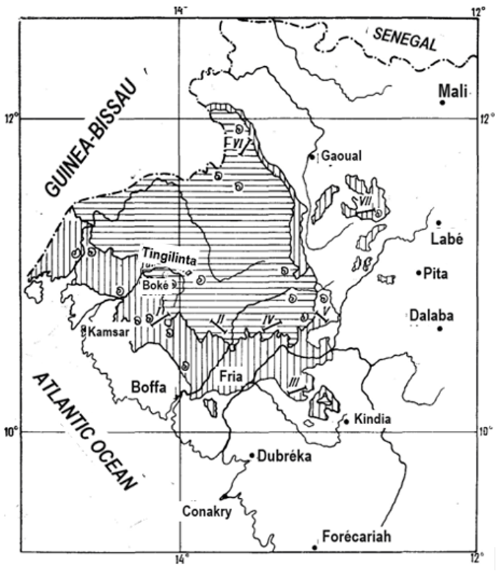
Fig. 1. Map of Middle Paleozoic Deposit Distribution in Guinea
1 — Outcrops of Silurian deposits; 2 — Outcrops of Devonian deposits; 3 — Fossil find locations; 4 — Location of sections; I-VII — Sections (I — Boffa; II — Fatala; III — Faro; IV — Balouma; V — Tairé; VI — Gaoual — Kandiafara; VII — Tomine)
The Telimele Formation reaches its greatest thickness in the southwest of the region, north of the city of Boffa. Here, it has been subdivided into five subformations by Yu. V. Bufeev, B. M. Kratov, M. M. Althausen et al. [4].
The first (lower) subformation is composed of argillites with interbeds of quartz coarse-grained siltstones or fine-grained clayey siltstones and, more rarely, sandstones. Four meters above the base of the formation, in a 15-meter-thick argillite horizon, remains of graptolites were collected: Climacograptus ex gr. scalaris (His.), Monograptus priodon (Bronn), M. cf. pandus Lapw., Petalograptus sp. indet., Petalograptus nov. Higher up, in a package of thinly bedded argillites and clays, numerous, uniformly distributed specimens of Monograptus priodon (Bronn), M. pandus Lapw., and Monograptus sp. indet. were collected. In the lower part of the package, Monograptus ex gr. sedgwicki (Portl.) is present. The total thickness of the lower subformation is 75-76 m.
Conformably overlying is a 140 m thick sequence of alternating argillites and siltstones, distinguished as the second subformation. In the lower part of the subformation lies a meter-thick interbed of black or reddish-brown micro-oolitic iron ores. Below this, 45 m from the base of the subformation, remains of brachiopods were collected: Diabolirhynchia aff. hollardi Drot, Strophochonetes sp., Protochonetes sp., Ancillotoechia ex gr. nucula (Sow.).
The third subformation is composed of argillites with interbeds of clayey siltstones and, more rarely, coarse-grained quartz siltstones. Its thickness is 100-110 m.
The fourth subformation is represented by clayey siltstones with interbeds of quartz siltstones and a horizon of iron ores in the upper part of the section. The thickness of the subformation is 90-95 m.
In the structure of the fifth (upper) subformation, argillites with interbeds of siltstones and seams of fine-grained sandstones predominate. The thickness of the subformation is about 100 m, while the total thickness of the entire Telimele Formation in this area is 520-550 m (Fig. 2, 1).
In the northwest, closer to the border with Guinea-Bissau, the Telimele Formation can only be subdivided into two parts [5]: its lower part is composed of quartz siltstones with rare seams of fine-grained quartz sandstones. Higher up, the proportion of sandstones increases, and interbeds of thinly bedded argillites appear. Organic remains have long been known from this area. E. Chételat [8] collected remains of graptolites Monograptus priodon (Bronn) and pelecypods Cardiola interrupta Sow. 45 km northwest of the city of Boké. In the same location, V. Lozovskiy [13] collected monograptids. The author’s collection from this point contains remains of brachiopods, cephalopods, crinoids, and graptolites Monograptus flexibilis belophorus (Men.) and Monograptus sp., which, according to T. A. Koren, are characteristic of the upper Lower - lower Middle Wenlock. Furthermore, near the settlement of Ouassadou, E. Chételat [8] encountered Petalograptus ex gr. palmeus (Barr.). Specimens identified by T. A. Koren in the author’s collections from the same point – Petalograptus cf. giganteus Bouček et Münch, P. ex gr. Palmeus (Barr.), Paraclimacograptus innotatus (Mich.) − indicate the boundary beds of the Middle and Upper Llandovery.
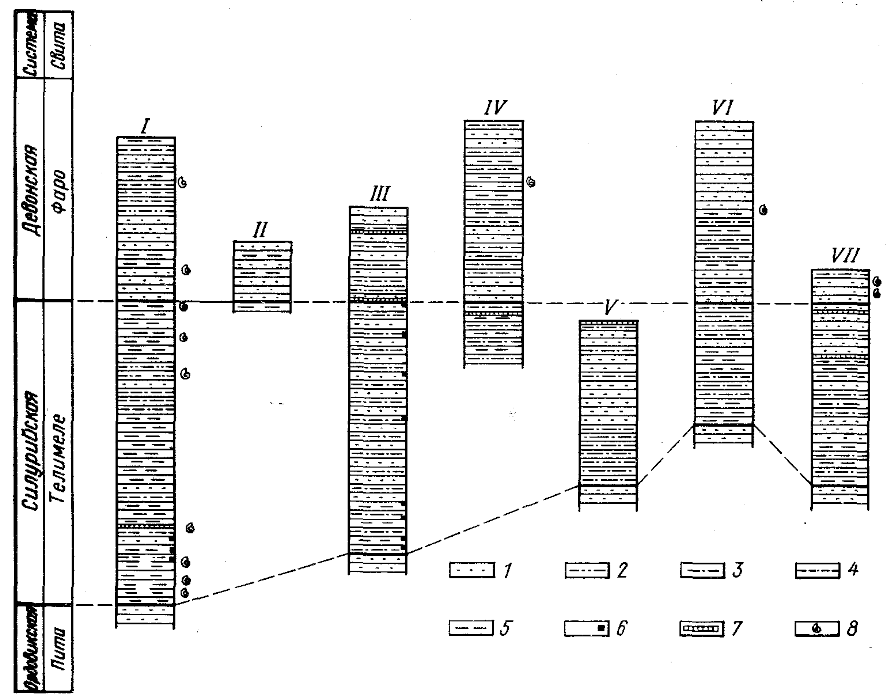
Fig. 2. Correlation Diagram of Middle Paleozoic Sections in Guinea
1 — sandstones; 2 — sandy siltstones; 3 — siltstones; 4 — silty argillites; 5 — argillites; 6 — pyritization; 7 — micro-oolitic iron ore horizons; 8 — fossil finds. For explanations of the Roman numerals, see the caption to Fig. 1
In the lower reaches of the Fatala River, argillites and silty argillites predominate in the lower and upper parts of the Telimele Formation, while siltstones with interbeds of quartz sandstones dominate the middle part. Further east, the formation is composed of siltstones, silty argillites, and argillites enriched with pyrite and mica, with rare seams of sandstones (Fig. 2, III).
On the left bank of the Konkouré River, the composition of the formation changes again [7]. On the western slope of Mount Faro, the formation has the following structure. Here, conformably overlying coarse-grained Ordovician quartz sandstones are (from bottom to top):
- Thinly interbedded siltstones and thinly laminated argillites. The thickness of individual layers varies from a few meters to 20–30 m ... 100 m
- Thinly laminated, coarse-grained quartz siltstones ... 10 m
- Siltstones and thinly laminated fine-grained sandstones with interbeds of argillites ... 330 m.
The total thickness of the section is 440 m. Above lie micro-oolitic ironstones and Devonian sandstones.
In the east, in the Telimele area, the formation’s composition is somewhat different [7]. Here it is composed exclusively of siltstones, predominantly coarse-grained. The full thickness of the Telimele Formation here is 285 m (Fig. 2, V).
In the extreme northeast of the region, on the watershed of the Kakrima and Tomine rivers, the formation is composed predominantly of siltstones and fine-grained sandstones with a subordinate amount of argillites and medium-grained sandstones [6]. In the upper half of the section, there are interbeds and lenses of hematite and magnetite ores up to 1-2 m thick. The rocks typically have thin horizontal bedding; often, they contain interbeds enriched with mica and syngenetic pyrite crystals. The thickness of the Telimele Formation in this area is 300-320 m (Fig. 2, VII).
The assignment of the Telimele Formation to the Silurian is established based on its stratigraphic position (conformable overlying of Ordovician rocks and underlying the Faro Formation, characterized by Lower Devonian fauna) and finds of remains of graptolites, brachiopods, cephalopods, and trilobites. In addition, remains of bivalves, crinoids, and ostracods are also found here.
Besides the fossil finds mentioned above, fossil fauna has been encountered by French, Soviet, and Guinean geologists at the following locations.
In the Boffa area, near the village of Sagulu, in argillites 70 m above the base of the Telimele Formation, graptolites Climacograptus ex gr. scalaris (His.), characteristic of the Llandovery, were collected [4]. E. Chételat indicates [8] finds of Monograptus sp., Phyllograptus sp. at the same location. The author collected Petalograptus sp., Paraclimacograptus (?) ex gr. innotatus (Mich.), Climacograptus sp., here known from the Middle Llandovery (conclusion by T.A. Koren). Further north, near the border with Guinea-Bissau, Llandovery graptolites were collected: Pseudoplagmatograptus ex gr. obesus (Lapw.), Petalograptus ex gr. palmeus (Barr.), P. giganteus Bouček et Münch, Monograptus (Streptograptus) sp. indet., Monograptus (Spirograptus) sp., and the Wenlockian Monograptus ex gr. flexibilis (Elles) (identifications by T.N. Koren). Finally, near Madina-Bové, 25 km from the city of Gaoual, R. Furon [11] encountered Monograptus priodon (Bronn).
Rich collections of organic remains were collected from the Telimele Formation in the Telimele area. Near the settlement of Gimaya, in the bed of the Kofu (a right tributary of the Fatala River), graptolites Diplograptus sp., Glyptograptus sp., Orthograptus ex gr. Truncates (Lapw.) were collected, considered Ordovician by T.A. Koren [7]. In the Tamissa mountains, near the settlement of Kalo, 80 m from the base of the Telimele Formation [7], Monograptus sedgwicki (Portl.), Monograptus sp. were encountered, indicating the boundary between the Middle and Upper Llandovery. 7 km southwest of Telimele, J. Sinclair collected Monograptus riccartonensis Lapw., M. priodon (Bronn), Retiolites geinitzianus Barr., which, according to H. Elle’s conclusion, are close to Wenlock forms and allow the correlation of the host deposits with the Niagaran of North America. Furthermore, H. Elle identified from Guinean collections Climacograptus hughesi (Nich.), C. scalaris (His.), Glyptograptus tamariscus var. incertus Elles et Wood, Monograptus sedgwicki (Portl.), M. distans Elles, Retiolites perlatus (?) Elles, indicating the Upper Llandovery [15]; however, where these collections were gathered is unknown.
The upper part of the Telimele Formation contains remains of brachiopods, predominantly Ludlovian. Near the settlement of Bullere (Telimele area), Ancillotoechia ex gr. nucula (Sow.), Diabolirhynchia hollardi Drot, Howellela sp., Protochonetes sp., Dalmanella sp., Spirigerina ex gr. marginalis (Dalm.) were collected – identifications by M.A. Rzhonsnitskaya – and together with them trilobites Proetus (Proetus) cf. conspersus dnestroviensis Bal., Burmeisteria (Digonus) roemeri (Kon.), Acastella heberti (Goss), which, according to E.S. Levitsky, are characteristic of the uppermost Silurian or the base of the Gedinnian Stage.
Devonian deposits of Guinea are distinguished as the Faro Formation. Completing the Paleozoic section of this part of Africa, they fill the central part of the Bové Syneclise (the Kogon River basin, the upper reaches of the Tingilința and Fatala rivers) and also form small isolated areas in the Sagale settlement area (west of Labé) and northwest of the city of Kindia.
The Faro Formation is composed predominantly of quartz sandstones (often with ripple marks), siltstones and argillites with interbeds of micro-oolitic iron ores. Its lower boundary is drawn by mapping geologists at the appearance of a package up to 70 m thick of quartz sandstones and coarse-grained siltstones or at a package of interbedded siltstones, argillites, and sandstones. Often, a bed of micro-oolitic iron ores up to 2.7 m thick lies at the base of the formation.
In the west of the region, near the city of Boké, in the lower part of the formation, according to observations by A.A. Belyaev, sandstones with interbeds of siltstones from 2 to 15 m thick predominate. 60 m from the base of the formation, brachiopods Lingula ex gr. Rectangularis Ljasch., Lingula sp. indet., the trilobite Acastoides cf. hollardi Alberti, and poorly preserved tentaculites were encountered.
In the upper parts of the Faro Formation, whose thickness here does not exceed 280 m, indeterminable to species representatives of the brachiopod genera Leiorhynchus, Lingula, Chonetes were encountered.
In the north, near the border with Guinea-Bissau, fine-grained quartz and quartzitic sandstones also predominate in the lower part of the formation [5]. The middle part of the formation is composed of interbedded siltstones and argillites, sometimes with pyrite and individual sandstone interbeds up to 1 m thick. The siltstones contain numerous imprints of brachiopods, crinoids, and bryozoans. The upper part of the formation is represented by variegated, thinly banded, fine-grained quartz sandstones (Fig. 2, III). Subordinate are interbeds of dense siltstones and argillites up to 1.5 m thick. The total thickness of the formation here is 320 m.
Near the settlement of Telesita, the Faro Formation is represented by sandstones, sometimes cross-bedded, with interbeds of siltstones and argillites, containing imprints of pelecypods and brachiopods of the families Strophomenidae, Chonetidae, and Acrospirifer ex gr. primaevus (Schl.).
At the confluence of the Fatala and Telubu rivers (Fig. 2, II), apparently only the lower part of the Devonian deposits, preserved from erosion and not exceeding 105 m in thickness, is observed.
One of the most complete sections of the Faro Formation is described by Soviet geologists [7] near Mount Balouma, northeast of the settlement of Ningétidé (Fig. 2, IV). Here, overlying the siltstones of the Telimele Formation are (from bottom to top):
- Fine-grained sandstones with interbeds of siltstones up to 2-3 cm thick: 40 m
- Clayey quartz siltstones, thin and parallel-bedded: 60 m
- Fine-grained quartz sandstones with interbeds of siltstones: 30 m
- Frequently alternating argillites and siltstones with remains of brachiopods Alatitormiajackeli Scupin, Schizophoria cf. provulgaria Maurer, Acrospirifer ex gr. Arduannensis (Schnur): 130 m
- Fine-grained quartz sandstones with interbeds of siltstones: 30 m
- Quartz siltstones, thinly bedded: 20 m
The total thickness of the rocks in the section is 310 m.
In the northeastern part of the region [5, 6], the Devonian deposits are subdivided into two packages: a lower one, predominantly sandstone, and an upper one, siltstone-argillite (Fig. 2, VII).
Based on the correlation of individual sections, the maximum preserved thickness of the Faro Formation, surviving erosion, is estimated at 400 m [7].
The presence of Devonian deposits within Guinea was first proven by E. Chételat [9], who discovered near the settlement of Thion-Thian Trigonia aff. Guerangeri Vern. and other indeterminable brachiopods, and near the village of Fookoure Meganteris sp. And Amphigenia sp., which, according to the determination by Maillieux, indicate a Lower Devonian age.
In general, the brachiopods characterizing the Faro Formation are subdivided by the author into two assemblages.
The first assemblage was discovered in the Tapoti area on the Boffa sheet (Fig. 1, I), in the Balouma mountains on the Telimele sheet (Fig. 1, IV), and near the village of Sagale on the Labé sheet. The assemblage is represented by Bicarinatina (?) mira Condé sp. nov. (ms), Tropidoleptus carinatus (Conrad), Chonetes sp., Plebejochonetes sp. 2, Gorgostrophia (?) sp., Acrospirifer ex gr. arduennensis (Schnur.). This assemblage also includes Strophomenidae, Chonetidae, Acrospirifer ex gr. primaevus (Schl.), Rensselaria (?) sp., which, according to M.A. Rzhonsnitskaya, indicate the Lower Devonian, possibly the Siegenian Stage, as well as Schizophoria sp., Schellwienella ex gr. umbraculum (Schl.), Chonetidae, Lingula sp., Acrospirifer ex gr. arduennensis (Schnur.), A. guineicus sp. nov. (in coll.), Alatiformia jackeli (Scupin), Athyris (?) sp., found 250 m above the base of the Faro Formation in the Balouma mountains and indicating the Lower Emsian (conclusion by M.A. Rzhonsnitskaya).
The brachiopods collected by A.D. Petrovsky et al. [6] in the Sagale area, Manispirifer cf. gosseleti (Bec.), Fimbrispirifer cf. trigeri (Vern.), Acrospirifer ex gr. primaevus (Schl.), Australocoelia (?) sp., as well as the brachiopods collected together with trilobites in the lower part of the Faro Formation near the city of Boffa, probably also belong to the first assemblage.
The second assemblage includes Tropidoleptus carinatus Conr., Sphenophragmus spectabilis Condé sp. nov. (ms), Protoleptostrophia aff. concinna (Sh. et M.), Xystostrophia guineensis Condé sp. nov. (ms), Chonetes sp., Plebejochonetes sp. 1, Cupularostrum sp., Pustulatia sinthiourensis Condé sp. nov. (ms), Pustulatia bokaria sp. nov. (ms), Mucrospirifer sp. 1, Mucrospirifer sp. 2, Spinocyrtia sp. 1, Spinocyrtia sp. 2. This assemblage was discovered by us in the Sintiourou area near the city of Gaoual and around Hakoundé-Thiangui, on the Telimele sheet, and is of Givetian age. The third assemblage of M.A. Rzhonsnitskaya [7], which includes Schizophoria sp., Chonetes sp., Devonochonetes ex gr. coronatus Hal, Pinulicosta sp., Cupularostrum sp., Mucrospirifer ex gr. mucronatus (Conr.), Pustulatia pustulosa (Hall), as well as Longispina (?) sp., Pustulatia sp., Spinocyrtia sp. – determinations by M.V. Martynova [5] – should apparently also be included here.
Thus, the presence of the Lower and Middle Devonian within the Faro Formation is certain, but the absence of its upper boundary does not allow its age to be confined to these limits, since in Guinea-Bissau there are deposits of the Upper Devonian characterized by fauna [3].
The Devonian brachiopods of Guinea are quite distinctive. They show the greatest similarity with the Devonian brachiopods of South America.
The Middle Paleozoic deposits of Guinea are the result of an extensive transgression that covered Western and Northern Africa. The fine-grained sediments of the Telimele Formation probably accumulated in a shallow and quiet water basin dominated by reducing conditions.
The appearance of sandy material in the sediments of the late Silurian is evidence of uplift. The dynamics of the water basin changed; benthic representatives – brachiopods – could now live here. This uplift is evidence of an extensive regression, which continued into the Early Devonian and was especially pronounced north of the considered territory, where, as a rule, the Gedinnian Stage is missing from the sections [12]. In Guinea, on the contrary, sedimentation continued uninterrupted from the Ordovician until the Late Devonian. Here in the Devonian, unlike the Silurian, an oxidizing environment prevailed, as indicated by the presence of diverse benthic organisms.
References
- Belyaev A. A., Lazarenkov V. G., Seliverstov Y. P. Geology and the main nonmetallic minerals of the west of the Guinea Republic. - In book: Non-metallic minerals. Interuni. coll. L., PH LMI, 1974, pp. 75-81.
- Seliverstov Yu. P. Evolution of Relief and Cover Formations of the Humid Tropics of the Saharan Platform. L., Nedra, 1978, 239 p.
- Houghton S. G. Africa south of the Sahara. Geologic history. M., Mir, 1966, 365 p.
- Carte geologique de la Republique de Guinee a 1:200000 (Boffa). Notice explicative. Aut.: J. V. Boufeev, В. M. Krjatov et autres. Serv. Min.M.D.E. Conakry, 1970, 182 p.
- Carte geologique de la Republique de Guinee a 1:200000 (Kandiafara-Gaoual). Notice explicative. Aut.: J. B. Samozvantzev et autres. Serv. Min.M.D.E. Conakry; 1974.
- Carte geoTogique de la Republique de Guinee a 1:200000 (Labe. Notice explicative. Aut.: A. D. Petrovsky et autres. Serv. Min.M.D.E. Conakry, 1976.
- Carte geologique de ia Republique de Guinee a 1:200000 (Te'limel). Notice explicative. Aut.: Y. P. Seliverstov, A. A. Beljaev, V. V. Volkov et autres. Serv. Min.M.D.E., Conakry, 1970, 289 p.
- Chetelat E. Sur l'existence du Gothlandien en Guinee francaise. C.R., Ac. Sc., Paris, v. 207, 1938, p. 371.
- Chetelat E. Sur l' existence ciu De'vonien infe'rieur en Guinee franaise C.F Ac. Sc., Paris., v. 209, 1939, p. 446.
- Chetelat E. Notice explicative sur la feuille Kindia-Ouest. Carte geolog que de reconnaissance а echelle 1:500000. Dir. Min. A.O.F., Dakar, 1946, 28 p.
- Fur on R. Sur le primaire de la Guinle francaise. — Bull. Soc. Ge'ol. Franc ser. 5, v. 12. 1942. /
- Fur on R. Geologie de 1 Afrique. Ed. 3-eme. Paris, Рауо, 1968, 400 p.
- Konate H., Lozovski V. Les graptolites de la Guinee et leur signific; tion stratigraphique. Conf. scient. Fac. geo-mines, Boke, 1978, pp. 17—21.
- Lecointre G., Lemoine P. Sur les graptolites gothlandiens de la Guint francaise. Ass. Franc. Avanc. Scienc. C. R. de la 118 session, Liege, 1924, pp. 387—389.
- Sinс1air J. H. Discovery of Silurian fossils in French Guinea. — J. of Geeology, Chicago, 1928, № 36, pp. 475—478.