Application of the time-domain electromagnetic method for shallow groundwater prospecting IN Itay El-Baroud area, Nile Delta (Egypt)
- 1 — post-graduate student National Mineral Resources University (Mining University)
- 2 — professor Mansoura University
- 3 — professor National Research Institute of Astronomy and Geophysics
- 4 — professor National Research Institute of Astronomy and Geophysics
Abstract
The Nile Delta is not only the oldest known ancient delta, but also is the largest and most important depositional complex in the Mediterranean sedimentary basin. Furthermore, it is a unique site in Egypt that is suitable for accumulation and preservation of the Quaternary sediments. There are very few investigations which have been carried out on the Upper Quaternary sediments of the western part of the Nile Delta. The present paper is mainly concerned with the application of the geophysical technique in the form of electromagnetic method to investigate the Quaternary sediments sequence as well as detecting the groundwater aquifer in the area of study.A site of 232 TEM sounding in 43 stations were carried out using a «SIROTEM MK-3» time-domain system. A simple coincident loop configuration, in which the same loop transmits and receives signals, was employed. The loop side length was 25 m. A 1-D modeling technique was applied to estimate the depth and the apparent resistivity of the interpreted geoelectrical data.Based on the interpretation of the acquired geophysical data, four geoelectric cross-sections were constructed. These sections show that the Upper Quaternary sequence consists of three geoelectric layers. The Holocene Nile mud is split into two layers: the agricultural root zone (Layer 1); thick water saturated mud (Layer 2). The Upper Pleistocene sandy aquifer (Layer 3) has very complicated non-linear boundary.
None
Introduction
The Nile Delta, covering an area of about 12,500 km2, has been cultivated for several millennia. The research area is located in the central part of the western flank of the Nile Delta near the city of Itay El-Baroud (Fig. 1). It is localized between latitudes 30°50'-31° N and longitudes 30°35'-30°46'42'' E and covers an area of about 435 km2. Active agricultural activities are carried out on this area.
The sedimentary deposits of the Nile Delta are the largest and most famous delta complex of the Mediterranean sedimentary basin. In addition, it is the only area in Egypt where modern accumulation of Quaternary sediments is taking place. Thus, the Nile Delta trough has the most complete section of Quaternary sediments in Egypt. Here, the sediments have the greatest capacity and are divided into several stratified units. The Quaternary deposits of the Nile inconsistently lie on formations of the Pliocene or older sediments [3]. According to A. Rizzini et al. [5], the maximum thickness of Quaternary sediments here reaches 1000 m, with a decrease in thickness in the direction of the southern margin of the delta. In the middle part of the Nile Delta, the thickness of the stratum is about 500 m.
To date, a small number of geophysical studies have been carried out here aimed at studying the tops of Quaternary sediments. This paper presents the results of studies of the features of the radial stratification of quaternary sediments and the morphology of the roof of an underground aquifer using the electromagnetic TPM.
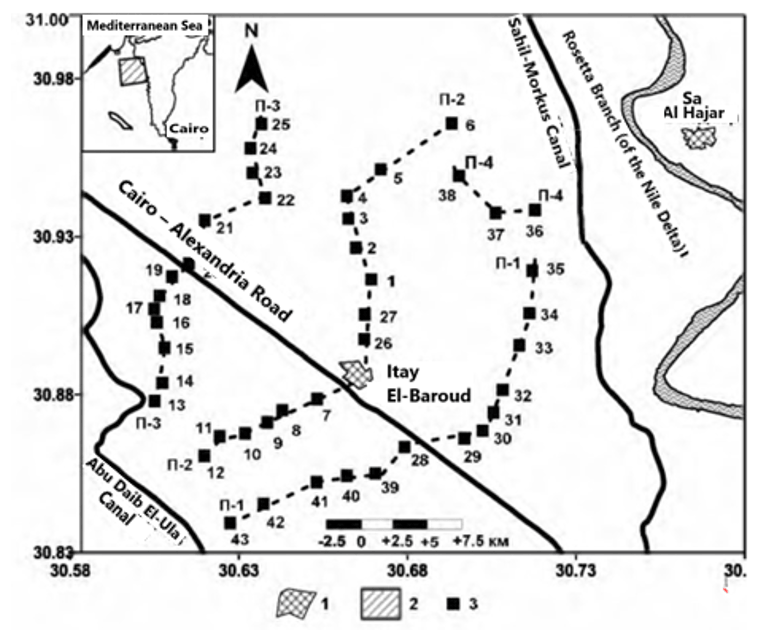
Fig. 1. Layout of electrical exploration profiles on the research area (Itay El-Baroud area)
1 – cities; 2 – location of the research area on a small–scale scheme; 3 - location of electrical exploration stations, transient process method (TPM)
Lithostratigraphy
According to A. Rizzini and co-authors [5], two main formational complexes are distinguished in terms of material composition in the section of Quaternary sediments of the Nile Delta: the “Mit-Ghamr” formation and the “Bilgas” formation.
The “Mit-Ghamr” formation is of the same age as the “Prenile Qena” sand formation widespread in Egypt. It consists of quartz sands and conglomerates. Thin layers of clay, salt, and peat containing coastal or lagoon fauna mark the upper levels of this formation. The thickness of the “Mit-Ghamr” formation, which reaches 700 m in the northern part of the delta, decreases in a southerly direction [6]. The section of this formation shows variations in lithological composition from sandy facies (covering most of the delta) to sand shales in the northern marginal zones of the delta.
The “Bilgas” formation consists primarily of clays, salts, and fine-grained sand from river flood sediments. Plant remains and peat bogs are identified within its section. This formation represents an impermeable cap for the Quaternary deposits of the Nile Delta. The thickness of this formation varies from several meters in the southern part to 30 m in the northern part of the Nile Delta, reaching 77 m in some areas [6]. Lithological variations are noted in the “Bilgas” formation: clays and silts in the eastern and central parts of the Nile Delta; bottom sediments in the northern coastal areas; The sandy facies are in the south.
Hydrogeology
The specific electrical resistivity of sedimentary layers depends on their composition, water saturation, and the mineralization of groundwater [1, 4]. Consequently, when conducting electrical survey work, it is necessary to consider the hydrological and hydrochemical regimes of the aquifers in the Nile Delta.
Within the Quaternary deposits of the Nile Delta, two main aquifers are identified. The lower aquifer is a powerful layer of Pleistocene sands (the “Mit-Ghamr” formation) [4], which is overlain by impermeable Holocene clay strata (the “Bilgas” formation). Within the latter, lenses of sand (the upper aquifer) are distinguished, containing groundwater that infiltrates from drainage and irrigation channels. The salinity of groundwater in the Nile Delta aquifers ranges from moderate to excessively high. The lowest mineralization values are observed in the southern parts of the delta region and in areas close to irrigation channels and Nile branches.
Geophysical research
Over the past three decades, electromagnetic methods have been widely used to map patterns of lateral and vertical variability in sedimentary resistances. In recent years, the TPM has been used to identify the main aquifers within the basins identified by this method at the stage of regional studies [2].
In the course of field research, we performed 232 measurements using the TP method at 43 observation points using the Australian SIROTEM MK-3 electromagnetic stations (Fig.1). The SIROTEM MK-3 station includes a source and receiver mounted in a single portable console. The source creates an electrical pulse in the loops of the cable laid on the daytime surface. The same loop is usually used as the receiver of the electromagnetic signal. The length of the loop side was 25 m. All the observations were repeated four or five times.
Processing and interpretation of TPM data
Recordings with the best useful signal-to-noise ratio were selected for processing. The module of the TEMIXXLV4 (1996) one-dimensional (1D) modeling program was used to calculate the depth and apparent resistance of Quaternary sediment layers. When preparing the initial geoelectric model for calculating the 1D inversion of the TPM data, the results of borehole geological studies were taken into account. The modeling was performed using the “selection method”: the model parameters were selected in such a way as to ensure consistency between the TPM data and the borehole research data. Figure 2 shows typical examples of TPM sounding graphs and calculated geoelectric sections.
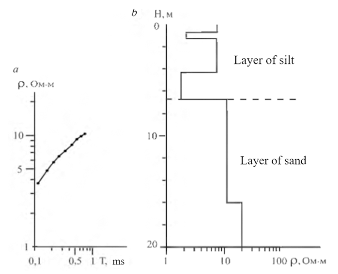
Fig. 2. A typical example of an electromagnetic sensing graph (a) and an interpretive geoelectric section (b).
Features of the structure of the study area based on geoelectric data
As a result of calibration of one-dimensional (1D) TPM data based on borehole research materials and taking into account geological mapping data, four detailed geoelectric sections were constructed. The section according to profile 2 is shown in Fig.3
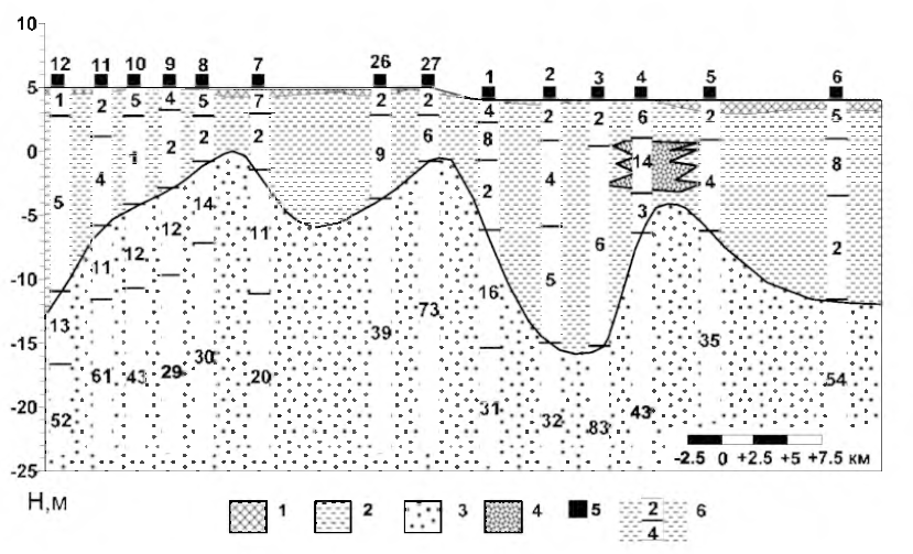
Fig. 3. Geoelectric section along the line of profile 2, constructed based on the results of 1D interpretation of the TPM data.
1 – agricultural layer; 2 – silt; 3 – coarse–grained sand; 4 - fine sand; 5 – TPM station number; 6 – resistivity values, Ohms·m
These sublatitudinal sections reflect the patterns of spatial distribution of the electrical resistivity of the upper part of the Quaternary sediments in both vertical and lateral dimensions. We used them as a basis for constructing reference lithological and stratigraphic sections of the research area.
Three geoelectric layers are distinguished in the composition of upper Quaternary deposits on geoelectric sections. The upper geoelectric layer (layer 1) is represented by silts of variable power (0.4-1 m). The electrical resistivity of this layer varies from 5 to 51 ohms·m. In some areas, the electrical resistivity reaches high values due to the development of interlayers of sandy clays. This layer is closely related to the aeration zone and is usually used in agricultural activities.
The second geoelectric layer (layer 2) consists of water-saturated silts from 3 to 23 m thick. The values of the electrical resistivity here vary from 1 to 10 ohms·m. However, in some areas, small sand lenses with relatively high resistances (up to 14 ohms·m) are distinguished in this layer. Such values are noted, in particular, at the TPM station No. 4.
The third geoelectric layer (layer 3) is the Pleistocene sands, which are the main aquifer of the research area. This layer is manifested by increased resistivity values in comparison with the overlying layers (11-83 ohms·m).
The results of the joint interpretation of the TPM and drilling data were used by us to model the morphology of the lower boundary of the silt layer of the Holocene “Bilgas” formation and its total capacity. According to the isopachite map (Fig. 4), the thickness of Holocene silts varies from 2 to 23 m. The thickness of this layer reaches its maximum values in the northwestern, western, eastern and southern parts of the research area. These areas correspond to depressions of Pleistocene sands. The geological model of the study area is shown in Fig. 5.
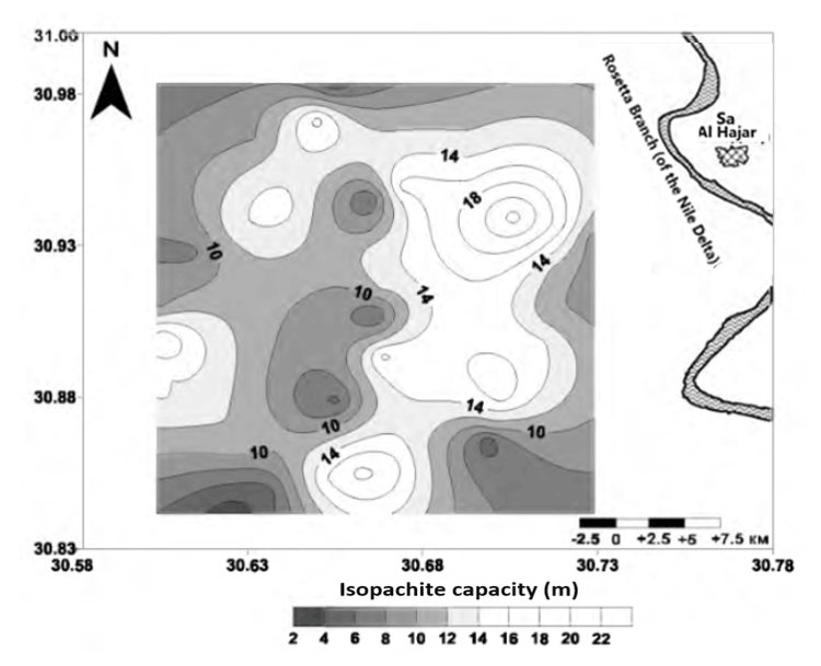
Fig. 4. Holocene silt thickness isopachites of the Nile Delta (Itay El-Baroud area)
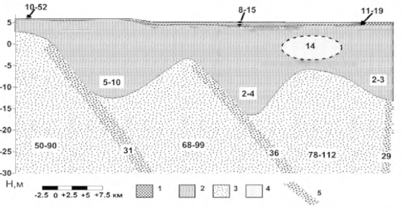
Fig.5. Generalized geological model of the study area, obtained from the results of the TPM
1 – agricultural layer; 2 – silt; 3 – coarse-grained sand; 4 – fine sand;
5 – the estimated position of the fault zones
Conclusion
The use of electromagnetic research methods ensures the creation of a structural and material basis for a model of the deep geological structure of the Nile region. The basis of the deep constructions are three geoelectric sections, which reflect the features of the deep structure of the research area.
Within the research area, there is a network of irrigation water channels through which surface waters penetrate into the lower horizons, which is reflected in the electrical resistivity sections.
References
- Atwia M.G., Khalil J.B., El Awady M.M., Habib M.M. Hydrochemistry and water quality of groundwater in the central part of the Nile Delta, Egypt. Egyptian Journal of Geology. 1996. Vol.41/2B, p.743-764.
- Kaufmann A.A., Keller G.V. Frequency and transient sounding. Methods in Geochemistry and Geophysics, Elsevier Publ. Co., 1983. Vol.16, p.685.
- Said R. The geological evaluation of the River Nile. New York, Heidelberg, Berlin: Springer Verlag, 1981, p.151.
- Serag El-Din H.M. Geological, hydrogeological and hydrological studies on the Nile Delta Quaternary aquifer. PhD Thesis, Faculty of Science, Mansoura University, Egypt, 1990, p.300.
- Rizzini A., Vezzani F. Cococcetta V., Milad G. Stratigraphy and sedimentation of Neogene-Quaternary section in the Nile Delta area (A.R.E.). Marine Geology. 1978. Vol.27, p.327-348.
- Zaghloul Z.M., Taha A.A., Hegab O.A., El-Fawal F.M. The Neogene-Quaternary sedimentary basins of the Nile Delta, Egypt. Journal of Geology. 1997. Vol.21, p.1-19.