Assessment of rock massif sustainability in the area of the underground research laboratory (Nizhnekanskii Massif, Enisei site)
- 1 — Junior Researcher Geophysical Center of the RAS ▪ Orcid
- 2 — Researcher Geophysical Center of the RAS ▪ Orcid
- 3 — Ph.D., Dr.Sci. Corresponding Member RAS Geophysical Center of the RAS ▪ Orcid
- 4 — Junior Researcher Geophysical Center of the RAS ▪ Orcid
- 5 — Chief Specialist Geophysical Center of the RAS ▪ Orcid
Abstract
The study presents the results of the research on geodynamic and geological conditions of the Enisei site (Krasnoyarsk Krai), chosen for the construction of an underground research laboratory. The laboratory is being built at a depth of 500 m to assess the suitability of the rock mass for burying high-level radioactive waste. The rocks consist of weakly fractured gneisses, granites, and dikes of metadolerites. Field observations were conducted on bedrock outcrops. They included the determination of rock mass quality indicators, measurement of rock fracturing, and a rating classification of stability using N.Barton's method. GNSS observations were also made to monitor surface deformations. These data were used to develop a three-dimensional structural model, including lithology, fault disruptions, intrusive bodies, elastic-strength properties of rocks, and the sizes of zones influenced by faulting. It will serve as a basis for boundary conditions and the construction of three-dimensional variational models of stress-strain states, identifying zones of concentration of hazardous stresses, and planning in situ geomechanical experiments in underground mines of the laboratory. The obtained values of the modified QR index for the main types of rocks allowed their classification as stable and moderately stable, corresponding to strong and very strong rocks on Barton's scale and the massif rating according to geomechanical classification.
This work was conducted in the framework of budgetary funding of the Geophysical Center of RAS, adopted by the Ministry of Science and Higher Education of the Russian Federation.
Introduction
In Russia, a vast amount of radioactive waste (RAW) has been accumulated, and its surface storage poses an extraordinary danger to the population and the environment. The most hazardous are high-level RAW containing radionuclides with a half-life of more than 10,000 years. At the current level of scientific and technological progress, the most reliable method for removing them from the biosphere is the disposal of RAW in deep impermeable geological formations (crystalline rocks, salts, tuffs). The fundamental condition for ensuring the geoecological safety of RAW disposal is the isolation capabilities of the rock massif and a low-activity geodynamic regime of the area. The safety concept of geological repositories for RAW is based on the principle of multibarrier systems, where a complex of engineering and natural barriers ensures the isolation of RAW. Each barrier performs its functions for a specific period. Obviously, the most durable is the geological barrier. However, tectonic movements (slow creep and fast seismic) can lead to the destruction of the structurally-tectonic block (far zone) with the mines of the deep geological repository of RAW (DGR). Geomechanical processes, causing the formation of high-gradient stress zones or weakening the near-contour part (near zone) of the DGR mines, pose no less danger.
In 2022, the construction of an underground research laboratory (URL) began in the granitoid rocks of the Nizhnekanskii Massif, 20 km north of Krasnoyarsk, to make a final decision on the feasibility of building the deep geological repository for RAW [1, 2]. Research in URL is conducted in many developed countries that use nuclear technologies, including Sweden (Äspö), Finland (Onkalo), Switzerland (Grimsel), Germany (Gorleben) [3-5], Japan (Mizunami), China (Beishan), and others [6, 7]. In Russia, a research program is being developed for the URL of the Nizhnekanskii Massif. An important part of these studies is geomechanical experiments. Special chambers and deep boreholes are planned for their implementation [8-11]. Project decisions on the organization of monitoring systems include the justification of methods and measurement techniques, optimal locations for sensors, conducting field experiments, the selection of necessary equipment and technical means, interaction with other experiments, algorithms for processing observation results, etc. [12].
The article presents the results of developing a three-dimensional geomechanical model of the rock massif in the Enisei area as the initial stage of these works. It is assumed that based on this model, plans for the arrangement of chambers and boreholes for in-situ geomechanical experiments, the placement of sensors in the monitoring network, and the specification of boundary conditions for numerical modeling of the stress-strain state (SSS) of rocks within the area will be developed.
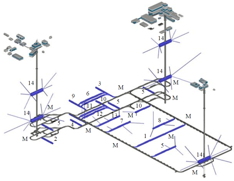
Fig.1. Schematic diagram of the URL (research mines are highlighted in blue), numbers indicate planned experiments on geomigration (1-3); geochemistry (4); geomechanics (5); engineering barriers (6-8); microbiology (9); gas release (10); RAW packaging technology development (11, 12); burial prototype (13); hydrogeology (14); M – monitoring stations
Methods
In Fig.1, a variant of the volumetric-planning solution for the location of research mines in the underground research laboratory at the end of 2018 is presented. The laboratory is situated at a depth of 500 m from the Earth's surface and includes three shafts (ventilation, operational for the descent of radioactive waste and personnel), a system of horizontal mines, research chambers, and boreholes. This scheme is preliminary and will be refined depending on the identification of geological structure features [1]. Before the excavation of mines, a classification of the stability of hosting rocks should be developed, and their critical properties influen-cing both the long-term stability of the URL and the provision of safe conditions for underground works at a depth of 500 m should be determined. The following main parameters should be taken into account [13-15].
Fault influence zones
Fault zones are potential pathways for the migration of nuclides beyond the sanitary zone of the DRG [16-18]. Zones of dynamic influence of faults are rocks that are strongly disturbed compared to the internal parts of structural blocks. If they intersect the site, they can act as triggers for hazardous geomechanical processes in the near-contour part of the mines and as channels for the infiltration of groundwater into the containers with RAW [19, 20].
Faults are classified into three categories depending on their length [13, 14]:
- class A – faults with a length ranging from several tens to several hundreds of kilometers;
- class B – faults with a length ranging from several kilometers to tens of kilometers;
- class C – faults with a length measured in meters or hundreds of meters.
The zone of dynamic influence of faults in this article is a rather general concept that includes all types of fractured zones. The width of the zone of dynamic influence for local and regional faults is calculated according to the formula provided in the article by G.G.Kocharyan [21],
where L – is the length of the fault, km; k – is a coefficient dependent on the scale and type of rock deformation. The range of variation for k is from 0.1 to 0.2 for local and regional faults, respectively [22]. Some authors suggest even smaller values for k (down to 10–4).
Areas with class A faults are prohibited from encompassing the construction site of the radioactive waste disposal facility. The presence of class B faults is allowed, but they should not intersect with mines intended for the disposal of radioactive waste. Class C faults are permitted to intersect with mines, but a rating assessment of rock quality is necessary to take additional measures.
Chemical index of underground waters
Reflects the basic chemical properties of fluids – acidity, alkalinity, salt content, and other chemical elements that affect the corrosion resistance of engineering barriers. The chemical index CRchm includes three parameters: TDS – total dissolved solids content; pH – acidity/alkalinity; Cl – a parameter indicating the concentration of chloride ions in water. The value of the total chemical index is determined based on the composition of underground waters. With 6 < pH < 10, TDS < 50 g/l, Cl < 20 g/l, the geochemical environment is quite favorable and does not reduce the “quality” of rocks. The value of the geochemical parameter is determined as 1.0. If any of these requirements is not met, the geochemical environment is considered generally favorable, and a value of 0.8 is assigned. Otherwise, the geochemical environment is considered “not very suitable”, and it is assigned a relatively low value of 0.1.
Thermal effect
Due to the decay of radionuclides, the surrounding rocks will be exposed to elevated temperatures for an extended period (according to various estimates, around 120-150 °C for more than 150 years). Under the simultaneous influence of lithostatic pressure and tectonic stresses, this can significantly impact the stability of the rocks. The properties of rocks are considered in two aspects. The value of thermal conductivity can influence the layout decisions of the radioactive waste disposal facility. Another aspect is the alteration of the physical and mechanical properties under the influence of high temperatures. Experimental studies in [23] confirmed that high temperatures can lead to a significant decrease in the mechanical strength of geological formations. In this article, the thermal effect index is defined as the ratio of the compressive strength at maximum temperature to the strength at room temperature Ccd:
It is proposed to use the weighted average value of the thermal effect index in case there are several types of rocks in the studied area. For example, if granite and metamorphic rock (gneiss) are present in a ratio of 70 and 30 %, respectively, the index is calculated using the formula:
Q-index according to N.Barton. According to the research conducted at the Äspö underground laboratory (Sweden) [6], it has been revealed that the parameters of the stress relaxation factor (SRF) and rock moisture content (Jw) are not suitable for assessing the stability of the rock mass during the underground isolation of radioactive waste [24, 25]. Therefore, in the system for assessing the suitability of the rock mass for the disposal of radioactive waste, it is accepted to use the product of four parameters:
where RQD – is the rock quality designation; Jn is the number of joint sets; Jr is the joint roughness coefficient (roughness of the most unfavorable joint); Ja is the alteration and condition of the joints.
The rock quality index, characterizing their structural disruption, is calculated using the formula [26-28]:
where LΣ – is the sum of the lengths of distances between natural cracks longer than 10 cm, m.
Hydraulic conductivity is the rate of fluid flow through pores and fractures. It plays a crucial role in determining the speed of radionuclide transport into the surrounding environment (in this case, the Yenisei River) in the event of the failure of engineered barriers. Hydraulic conductivity depends on permeability, saturation, fluid density, and viscosity. The index is determined as follows:
where K – is the specific hydraulic conductivity (or permeability) of the rock formations.
The strength-to-stress ratio index
The mechanical stability of mines primarily depends on the relationship between strength and the acting stresses in the rock mass [26, 29]. Typically, this is assessed by the ratio of uniaxial compressive strength to the maximum principal stress. This ratio is used as a factor of safety [30]. According to Barton's stability classification, it is determined by the formula:
where σс – is the rock strength under uniaxial compression; s1 – is the maximum stress in the rock mass; σс/σ1 > 5 – indicates a percentage of data related to the strength-stress ratio.
The paper [31] presents a rock classification system based on the Q-index by N.Barton, adapted to the specific features of underground radioactive waste isolation. The suitability index of host rocks includes factors such as thermal impact, chemical composition of groundwater, and permeability of the hosting massif. The modified index is determined by the formula:
Classification of rock massif by stability class is given in Table 1.
Table 1
Categories of rock massif according to stability class
|
QR |
Class |
Degree of stability |
Massif stability category |
|
[40, 1000] |
I |
High |
Resistant |
|
[10, 40] |
II |
Medium |
Medium resistant |
|
[0, 10] |
III |
Low |
Unstable |
Description of the rock massif
The Nizhnekanskii Massif is located in the accretion zone, at the contact of two major geological structures – the Siberian Platform and the West Siberian Plate [32]. The chosen area for the construction of the URL is approximately 2 × 3 km in size and is located in the northwest of the granitoid Nizhnekanskii Massif. Fig.2 shows the main tectonic disturbances
in the area [32]. A more detailed characterization of the tectonic and geological conditions is provided in [9, 30-32, 34]. The Pravoberezhnyi and Shumikhinskii faults divide the Enisei area into three structural blocks. According to geological data, the Right Bank fault is considered tectonically active. An analysis of the relief morphology reveals local faults and fractures. At a distance of 2-3 km to the west of the area's boundary, the active Muratov fault passes, which many geologists consider as the boundary between the Siberian Platform and the West Siberian Plate [8-9].

Fig.2. Structural-tectonic scheme of the area. Black lines represent faults: thick lines – major faults, medium-thick lines – regional faults, thin lines – local faults, dashed lines – presumed faults
1 – alluvial deposits (pebbles, sands); 2 – Jurassic deposits (sandstones, aleurolites, argillites); 3 – early Archean gneisses, crystal schists of the Atamanovsk series; 4 – Late Devonian biotite granites [33]
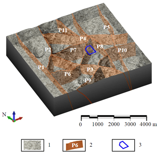
Fig.3. Three-dimensional model of major tectonic disruptions. Faults: P1 – Muratovskii; P2 – Atamanovskii; P3 – Kantatskii; P4 – Shumikhinskii; P5 – Pravoberezhnyi; P6 – Bezymyannyi; P7 – Studenyi; P8 – Meridionalnyi; P9 – Baikalskii; P10 – Bogdanovskii; P11 – N 1
1 – gneiss; 2 – faults; 3 – outline of the RAW disposal repository site
Based on the developed classification, a 3D model of the site was constructed, including 11 faults of various classes. The three-dimensional model is visually shown in Fig.3. Among the faults, two belong to class A and extend for more than 30 km. They are located in the western part of the studied area. Within the construction site of the underground laboratory, faults of class C with lengths ranging from 300 to 1000 m were identified. These local faults are oriented to the northeast, and their number exceeds 16. According to the suitability assessment classification, class A faults do not reach the construction site boundary. The class B fault (Bezymyannyi) intersects the construction site but does not reach the repositories of the RAW disposal facility. It can be concluded that the Enisei site is assessed as suitable for the construction of the URL.
On the Enisei site, 17 boreholes were drilled with core sampling, and the determination of the physico-mechanical properties of the rocks was performed (Table 2) [35]. Due to the lack of documentation for the core material to determine the stability categories of rock masses, geotechnical documentation of rock outcrops was carried out in 2021-2022 to assess the degree of rock disturbance and stability [33]. Statistical analysis of the results showed that fractures in the dynamic influence zone of the Muratovskii fault have a northeast direction (Fig.4, c), the Bezymyannyi fault has a northeast-southwest and southeast-northwest direction (azimuths of approximately 10° and 130°) (Fig.4, d). In contrast to the granite-gneiss rocks, the dike complexes of metadolerites are less fractured [35].
Table 2
Summary physical and mechanical properties of rocks at the Enisei site
|
Characteristic |
Rocks |
|
|
Gneisses |
Metadolerites |
|
|
Volume weight, t/m3 |
2.75 |
2.91 |
|
Poisson's ratio |
0.27 |
0.29 |
|
Modulus of elasticity, MPa |
(7.0-7.7)∙104 |
9.15∙104 |
|
Modulus of deformation, MPa |
5.9∙104 |
7.09∙104 |
|
Uniaxial compression strength, MPa |
131.0 |
143.9 |
|
Tensile strength, MPa |
12.89 |
12.41 |
|
Shear strength, MPa |
57.15 |
99.6 |
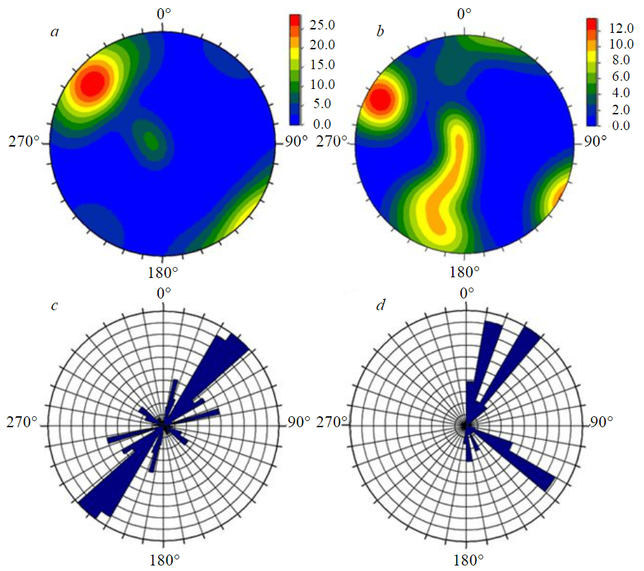
Fig.4. Stereograms of rock fracturing in the Lower Jurassic formation in the zones of dynamic influence of the Muratovskii (a) and Bezymyannyi (b) faults; rose diagram of fracturing in the zones of dynamic influence of the Muratovskii (c) and Bezymyannyi (d) faults
At a distance of 3 km from the Enisei site, previous stress assessment work was conducted using the hydraulic fracturing method. The results showed horizontal stresses σxx = σyy = 13.5 MPa, and vertical stress σzz = 12 MPa. In other studies [33, 40], it is noted that stresses in the rock massif reach 21.4 MPa. As can be seen, the data are quite contradictory. During the geotechnical documentation of rock outcrops on the site, samples were uniformly selected in various geological conditions. The zone of dynamic influence of the Muratovskii fault was thoroughly studied, and measurements were taken at four geological sites at a distance of up to 1 km from it.Three additional sites were chosen away from local tectonic disturbances, in the masses not affected by intrusive dike bodies. Five research sites corresponded to local-scale fault disruptions – Baikalskii, Kantatskii, Bezymyannyi, Verkhne-shumikhinskii, and Merkurevskii faults. Another four sites were described during reconnaissance routes, where intrusive dike complexes of metadolérites were identified. All the data were summarized based on the rock stability categories according to the QR value and systematized in Table 3.
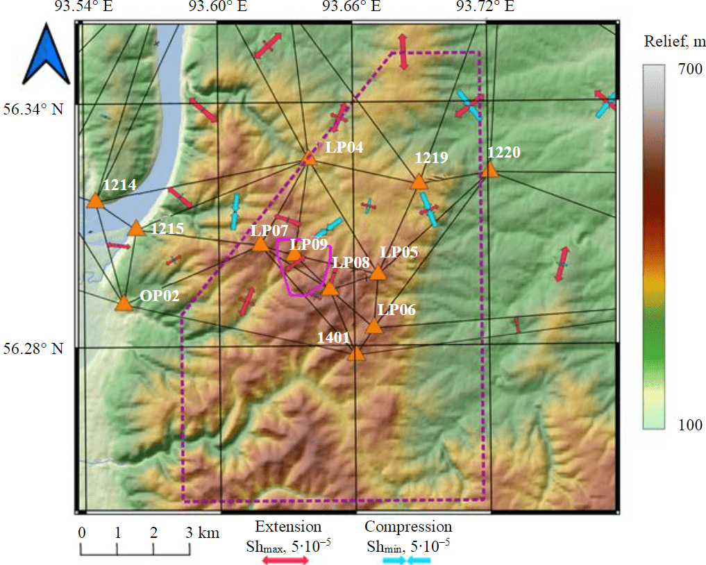
Fig.5. Principal axes and velocities of horizontal deformations determined from GNSS observations during the period from 2012 to 2021 [8]
- category 1 – 500-meter zone of dynamic influence of the Muratovskii fault. The rocks mainly consist of granites and gneisses with veins of quartz and thin dikes of metadolerites;
- category 2 – zones of dynamic influence of local-scale fault disruptions. The rocks are predominantly granites and gneisses with veins of quartz and thin dikes of metadolerites;
- category 3 – intrusive complexes represented by thicker dikes of metadolerites, with a thickness of up to 10-20 m;
- category 4 – outside the zone of dynamic influence of fault disruptions. The rocks are mainly expressed as granites and gneisses.
Table 3
Rock stability classes
|
Category |
Q' |
CRchm |
CRT |
JRW |
SRF |
QR |
Class |
|
1 |
13 |
1.0 |
0.80 |
1.0 |
0.5 |
20.8 |
II |
|
2 |
86 |
1.0 |
0.88 |
1.0 |
0.5 |
151.4 |
I |
|
3 |
22 |
1.0 |
0.87 |
0.8 |
0.5 |
30.6 |
II |
|
4 |
68 |
1.0 |
0.85 |
0.7 |
0.5 |
80.9 |
I |
Hydrochemical studies have shown that the overall mineralization ranges from 50 to 450 mg/l, and the water is hydrocarbonate-calcium [41]. The average pH value is 8.1, and the total hardness does not exceed 6.25 °F. The nitrate ion content is below 3.76 mg/l, and chloride levels range from 0.9 to 7.5 mg/l. Therefore, the requirements for geochemical parameters are met, and the geochemical parameter can be accepted as 1.0. The thermal effect index
The next stage of the work involved creating a three-dimensional geological model based on the analysis of archival geological-geophysical data [42-44]. Using geological cross-sections and diagrams of various horizons, a framework and block geological-structural model of the Enisei site were developed [33]. The lithological model includes three layers of rocks: Quaternary deposits and weathering crust formations with a thickness of up to 20 m. The upper layer consists of plagiogneisses and biotite gneisses with layers of crystalline schists. The lower layer consists of cordierite-biotite gneisses with layers of biotite and garnet-bearing gneisses (Fig.6, a). Disruptive disturbances on the site are represented by zones of crushing, mylonitization, tectonic breccias, and fractures without displacement (Fig.6, b, c) [33, 35]. The tectonic faults in the model are classified into major and minor disruptions. Intrusive and ultrametamorphic formations are represented by a dense network of steeply dipping metadolerite dikes with a thickness of up to 30 m (Fig.6, d). Disruptive disturbances on local and regional scales are detailed in the study [33]. Additionally, zones of crushing and deformation, based on geological cross-section data, were incorporated into the model. These zones closely correlate with the major faults of the site, extending to depths of up to 700 m.
The block model, constructed based on the framework model (Fig.6, a, c), represents geological structural features in the form of blocks with specific physical and mechanical properties (Fig.7, a). This model is used for a more detailed and accurate description of the geological structure and behavior of the rock mass.
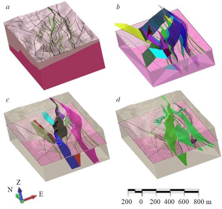
Fig.6. Three-dimensional representation of the main geological structures in the 3D model of the Enisei site: a – lithological model; b – model of discontinuous faults; c – zones of fracturing, increased fissility, and brecciation; d – intrusive and dyke complexes
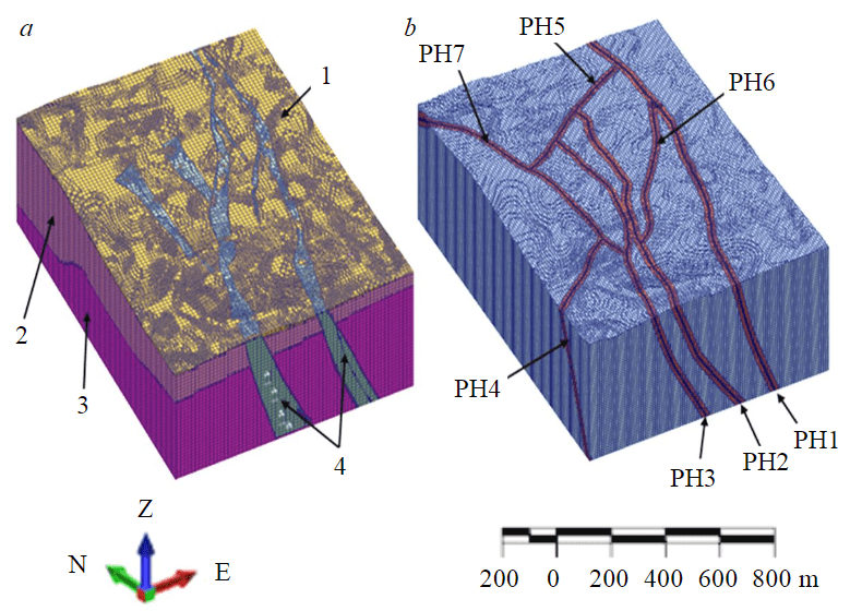
Fig.7. Structural block model and zones of dynamic influence of major fault disruptions
1 – Quaternary deposits; 2 – upper layer; 3 – lower layer; 4 – zones of increased fracturing; faults: PH1 – Verkhneshumikhinskii; PH2 – Verkhnemerkurevskii; PH3 – Merkurevskii; PH4 – Bezymyannyi; PH5 – N 5; PH6 – N 6; PH7 – N 7
In the framework model (see Fig.6, b), fault disruptions were represented as surfaces (dislocations) with zero width due to a lack of information about the thickness of the faults [33]. Using empirical relationships, the dimensions of the zones of dynamic influence of fault disruptions were determined, and based on this information, a block model was constructed (Fig.7, b).
Building a block model of faults with zones of dynamic influence is an important tool for variational modeling of stress-strain states, analysis, and assessment of geodynamic processes occurring in the rock mass.
Conclusion
For the safe disposal of high-level RAW, it is crucial to determine the critical properties of rock formations that influence both the long-term stability of the geological repository for RAW and the provision of safe conditions for underground mining operations. Global experience analysis has shown that empirical rating classifications are effectively used for this purpose. To assess the stability of the rock mass surrounding the underground openings of the geological repository for RAW, existing classifications have been modernized.
The modernized QR index incorporates parameters that consider fault zones, the strength-to-stress factor (SRF), the Q index, and others. Preliminary results of the rock mass stability assessment have indicated that the selected site is suitable for the construction of the RAW repository. It has been determined that rock mass areas within the dynamic influence zones of major tectonic faults in the region are less stable, while intrusive rocks represented by dike complexes are more stable.
A three-dimensional structural-tectonic model of the Enisei site has been developed, which will subsequently serve as the basis for numerical variational modeling of the stress-strain state of the rock mass and the creation of a comprehensive geomechanical model of the site. Building a block model with zones of dynamic influence of fault disruptions is the first step toward a deeper understanding of fault behavior and their impact on the stability and safety of rock masses. The model will help identify zones of dangerous stress concentration and plan in-situ geomechanical experiments in the underground mines of the URL.
References
- Dorofeev A.N., Bolshov L.A., Linge I.I. et al. Strategic Master Plan for R&D Demonstrating the Safety of Construction, Operation and Closure of a Deep Geological Disposal Facility for Radioactive Waste. Radioactive Waste. 2017. N 1, p. 41-42.
- Abramov A.A., Bolshov L.A., Dorofeev A.N. et al. Underground Research Laboratory in the Nizhnekanskiy Massif: Evolutionary Design Study. Radioactive Waste. 2020. N 1 (10), p. 7-16. DOI: 10.25283/2587-9707-2020-1-9-21
- Joutsenvaara J., Holma M., Kotavaara O. et al. Callio Lab – the deep underground research centre in Finland, Europe. 17th International Conference on Topics in Astroparticle and Underground Physics, 26 August – 3 September 2021, Valencia, Spain. Journal of Physics Conference Series, 2022. Vol. 2156. N 012166. DOI: 10.1088/1742-6596/2156/1/012166
- Qiangyong Zhang, Chuancheng Liu, Kang Duan et al. True Three-Dimensional Geomechanical Model Tests for Stability Analysis of Surrounding Rock During the Excavation of a Deep Underground Laboratory. Rock Mechanics and Rock Engineering. 2020. Vol. 53, p. 517-537. DOI: 10.1007/s00603-019-01927-0
- Tsebakovskaya N.S., Utkin S.S., Kapyrin I.V. et al. Obzor zarubezhnykh praktik zakhoroneniya OYaT i RAO. Мoscow: Komtekhprint, 2015, p. 208 (in Russian).
- Koyama T., Chijimatsu M., Shimizu H. et al. Numerical modeling for the coupled thermo-mechanical processes and spalling phenomena in Äspö Pillar Stability Experiment (APSE). Journal of Rock Mechanics and Geotechnical Engineering. 2013. Vol. 5. Iss. 1, p. 58-72. DOI: 10.1016/j.jrmge.2013.01.001
- Saceanu M.C., Paluszny A., Zimmerman R.W., Ivars D.M. Fracture growth leading to mechanical spalling around deposition boreholes of an underground nuclear waste repository. International Journal of Rock Mechanics and Mining Sciences. 2022. Vol. 152. N 105038. DOI: 10.1016/j.ijrmms.2022.105038
- Tatarinov V.N., Morozov V.N., Kaftan V.I., Manevich A.I. Modern geodynamics of the southern of the Yenisei ridge derived from the results of satellite observations. Geophysical research. 2018. Vol. 19. N 4, p. 64-79 (in Russian). DOI: 10.21455/gr2018.4-5
- Kaftan V.I., Gvishiani A.D., Morozov V.N., Tatarinov V.N. Methods and results of determination of movements and deformations of the Earth’s crust according to GNSS data at the Nizhne-Kansk geodynamic test network in the area of radioactive waste disposal. Sovremennye problemy distantsionnogo zondirovaniya Zemli iz kosmosa. 2019. Vol. 16. N 1, p. 83-94 (in Russian). DOI: 10.21046/2070-7401-2019-16-1-83-94
- Manevich A.I., Tatarinov V.N., Kolikov K.S. Detection of crustal deformation anomalies with regard to spatial scale effect. Eurasian mining. 2019. N 2, p. 19-22. DOI: 10.17580/em.2019.02.04
- Gupalo V.S. Priority parameters of physical processes in a rock mass when determining the safety of radioactive waste disposal. Journal of Mining Institute. 2020. Vol. 241, p. 118-124. DOI: 10.31897/PMI.2020.1.118
- Demenkov P.A., Karasev M.A., Petrov D.N. Predicting Land-Surface Deformations During The Construction of Underground Facilities of Complex Spatial Configuration. International Journal of Civil Engineering and Technology. 2017. Vol. 8. Iss. 11, p. 1161-1171.
- Liang Chen, Ju Wang, Zihua Zong et al. A new rock mass classification system QHLW for high-level radioactive waste disposal. Engineering Geology. 2015. Vol. 190, p. 33-51. DOI: 10.1016/j.enggeo.2015.02.006
- Ju Wang, Liang Chen, Rui Su, Xingguang Zhao. The Beishan underground research laboratory for geological disposal of high-level radioactive waste in China: Planning, site selection, site characterization and in situ tests. Journal of Rock Mechanics and Geotechnical Engineering. 2018. Vol. 10. Iss. 3, p. 411-435. DOI: 10.1016/j.jrmge.2018.03.002
- Tong Y., Yue Y., Huang Z. et al. Modified RMR Rock Mass Classification System for Preliminary Selection of Potential Sites of High-Level Radioactive Waste Disposal Engineering. Sustainability. 2022. Vol. 14 (23), p. 1-17. DOI: 10.3390/su142315596
- Zhang Q., Liu C., Duan K. et al. True Three-Dimensional Geomechanical Model Tests for Stability Analysis of Surrounding Rock During the Excavation of a Deep Underground Laboratory. Rock Mechanics and Rock Engineering. 2020. Vol. 53, p. 517-537. DOI: 10.1007/s00603-019-01927-0
- Protosenya A.G., Karasev M.A., Belyakov N.A. Numerical simulation of rock mass limit state using Stavrogin’s strength criterion. Journal of Mining Science. 2015. Vol. 51. N 1, p. 31-37. DOI: 10.1134/S1062739115010056
- Kovalev O.V. Engineering and geomechanical forecast for waste disposal in underground caverns including earthquake-prone zones. Journal of Mining Institute. 2016. Vol. 217, p. 61-71 (in Russian).
- León Vargas R.P., Friedel M., Hassanzadegan A. et al. BARIK: an extended Hoek–Brown-based anisotropic constitutive model for fractured crystalline rock. Safety of Nuclear Waste Disposal. 2023. Vol. 2, p. 119-120. DOI: 10.5194/sand-2-119-2023
- Xie He-ping, Gao Feng, Ju Yang et al. Quantitative definition and investigation of deep mining. Journal of the China Coal Society. 2015. Vol. 40. N 1, p. 1-10. DOI: 10.13225/j.cnki.jccs.2014.1690
- Kocharyan G.G. Geomechanics of Faults. Moscow: GEOS, 2016, p. 424.
- Sherman S.I., Bornyakov S.A., Buddo V.Yu. Areas of Dynamic Influence of Faults (modeling results). Novosibirsk: Nauka, Sibirskoe otdelenie, 1983, p. 112 (in Russian).
- Wang F., Konietzky H. Thermo-Mechanical Properties of Granite at Elevated Temperatures and Numerical Simulation of Thermal Cracking. Rock Mechanics and Rock Engineering. 2019. Vol. 52. Iss. 10, p. 3737-3755. DOI: 10.1007/s00603-019-01837-1
- Barton N. A review of mechanical over-closure and thermal over-closure of rock joints: Potential consequences for coupled modelling of nuclear waste disposal and geothermal energy development. Tunnelling and Underground Space Technology. 2020. Vol. 99. N 103379. DOI: 10.1016/j.tust.2020.103379
- Barton N. Shear strength criteria for rock, rock joints, rockfill and rock masses: Problems and some solutions. Journal of Rock Mechanics and Geotechnical Engineering. 2013. Vol. 5. Iss. 4, p. 249-261. DOI: 10.1016/j.jrmge.2013.05.008
- Eremenko V.A., Ainbinder I.I., Marysyuk V.P., Nagovitsyn Y.N. Guidelines for selecting ground support system for the Talnakh operations based on the rock mass quality assessment. Gornyi Zhurnal. 2018. N 10, p. 101-106 (in Russian). DOI: 10.17580/gzh.2018.10.18
- Shaposhnik Y.N., Uskov V.A. Definitions qualitive characteristic (RQD) and rating (RMR) ore mass in the underground drive of the Skalisty mine. XIII Mezhdunarodnyi nauchnyi kongress i vystavka “Interekspo GEO-Sibir”, 19-21 April 2017, Novosibirsk, Russia. Interekspo GEO-Sibir, 2017. Vol. 2. N 2, p. 99-107 (in Russian).
- Protosenya A.G., Verbilo P.E. Research of Compression Strength of Fissured Rock Mass. Journal of Mining Institute. 2017. Vol. 223, p. 51-57. DOI: 10.18454/PMI.2017.1.51
- Anderson E.B., Savonenkov V.G., Lyubtseva E.F. et al. Results of survey and research works on site selection for underground disposal of HLW and SNF in Nizhnekansk granitoid massif (South Enisei Ridge). Trudy Radievogo instituta im. V.G.Khlopina. 2006. Vol. XI, p. 8-64 (in Russian).
- Kovalenko A.A., Zakharov N.E., Pul E.K., Zolotin V.G. Geomechanical aspects of the Internatsionalnaya kimberlite pipe mining. Gornyi Zhurnal. 2019. N 2, p. 27-31 (in Russian). DOI: 10.17580/gzh.2019.02.05
- Yong Ye, Liang Chen, Jian Liu. Study on Rock Mass Classification Methods Used in the Geological Disposal of High-level Radioactive Waste. 11th Conference of Asian Rock Mechanics Society, 21-25 October 2021, Beijing, China. IOP Conference Series: Earth and Environmental Science, 2021. Vol. 861. N 4. N 042118. DOI: 10.1088/1755-1315/861/4/042118
- Kochkin B.T., Malkovskiy V.I., Yudintsev S.V. Scientific basis for the safety assessment of long-lived radioactive waste geological disposal (the Eniseyskiy project). Moscow: IGEM RAS, 2017, p. 384 (in Russian).
- Akmatov D.Z., Manevich A.I., Tatarinov V.N., Shevchuk R.V. 3D structure tectonics model of Yenisei site of the Nizhnekansk Massif. Gornyi Zhurnal. 2023. N 1, p. 69-74 (in Russian). DOI: 10.17580/gzh.2023.01.11
- Kochkin B.T. Investigating the Geological Environment at the Yeniseisky Site: Tasks for the Current Stage of the Disposal Project. Radioactive Waste. 2019. N 2 (7), p. 76-91 (in Russian). DOI: 10.25283/2587-9707-2019-2 76 91
- Morozov O.A., Rastorguev A.V., Neuvazhaev G.D. Assessing the State of the Geological Environment at the Yeniseyskiy Site (Krasnoyarsk Region). Radioactive Waste. 2019. N 4 (9), p. 46-62. DOI: 10.25283/2587-9707-2019-4-46-62
- Tarasov B.G. Fan mechanism of dynamic shear fractures as a source of strength and brittleness paradoxes in rocks. Gornyi Zhurnal. 2020. N 1, p. 18-23 (in Russian). DOI: 10.17580/gzh.2020.01.03
- Biryuchev I.V., Makarov A.B., Usov A.A. Geomechanical model of underground mine. Part I. Creation. Gornyi Zhurnal. 2020. N 1, p. 42-48 (in Russian). DOI: 10.17580/gzh.2020.01.08
- Abdulla H. Al Nuaimi, Williams L.G. Sensitivity study of risk to future generations from geological disposal of radioactive waste in high strength rock in the UAE. Journal of Radiation Research and Applied Sciences. 2022. Vol. 15. Iss. 3, p. 218-231. DOI: 10.1016/j.jrras.2022.06.013
- Gunzburger Y., Magnenet V. Stress inversion and basement-cover stress transmission across weak layers in the Paris basin, France. Tectonophysics. 2014. Vol. 617, p. 44-57. DOI: 10.1016/j.tecto.2014.01.016
- Leontyev A.V., Rubtsova Y.V., Skulkin A.A. To the estimate of stress-strain state of the rock mass in the Nizhnekansky region. XVI Mezhdunarodnyi nauchnyi kongress i vystavka “Interekspo GEO-Sibir”, 18 June – 8 July 2020, Novosibirsk, Russia. Interekspo GEO-Sibir, 2020. Vol. 2, p. 109-116 (in Russian). DOI: 10.33764/2618-981X-2020-2-109-116
- Eremenko V.A., Vinnikov V.A., Kosyreva M.A., Lagutin D.V. Identification of rock jointing parameters by borehole imaging and interval geotechnical documentation of non-oriented drill cores. Gornyi Zhurnal. 2022. N 1, p. 21-26. DOI: 10.17580/gzh.2022.01.04
- Xuechao Wu, Gang Liu, Zhengping Weng et al. Constructing 3D geological models based on large-scale geological maps. Open Geosciences. 2021. Vol. 13. Iss. 1, p. 851-866. DOI: 10.1515/geo-2020-0270
- Biryuchev I.V., Makarov A.B., Usov A.A. Geomechanical model of underground mine. Part II. Application. Gornyi Zhurnal. 2020. N 2, p. 35-44 (in Russian). DOI: 10.17580/gzh.2020.02.04
- Kurtsev B.V., Fedotov G.S. MICROMINE-based geomechanical supervision of mining. Gornyi Zhurnal. 2022. N 1, p. 45-50 (in Russian). DOI: 10.17580/gzh.2022.01.08