Application of geophysical methods in prospecting for gold deposits in the Oda-Godere area
Abstract
The article discusses the results of pilot geophysical surveys conducted in 1987 at the Oda-Godere site using magneto- and electro-surveys (resistivity, induced polarization (IP) and natural electric field (EF) methods).
None
The article discusses the results of pilot-industrial geophysical studies conducted in 1987 at the Oda-Godere site using magnetic and electrical exploration, methods of resistance, induced polarization (IP) and natural electric field (EF). The study site is located in the Wollega province and is situated 75 km north of the village of Assosa. It is characterized by a weakly dissected relief with absolute elevations from 700 to 1000 m above sea level. The climate is dry and hot. Structurally, the site is located within the Precambrian volcanogenic-sedimentary folded belt. Its geological structure includes Late Proterozoic formations, which occupy about 95% of the area and are represented by metabasalts, various shales, marbles, phyllites and quartzites. The remaining 5% of the area, and only in the western part of the site, is occupied by cover basalts of Neogene-Quaternary age (Fig.1).
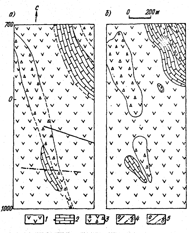
Fig. 1. Geological structure of the studied area:
a - shematic geological map of the eastern part of site; b - results of classification of geophysical fields according to complex features: 1 - metabasalts; 2 - marbles; 3 - brecciation zone; 4 - fautls (a - traced, b - suspected); 5 - geological contacts (a - traced, b - suspected)
Within the area, loose sediments with a thickness of 2 to 5 m are developed; sediments with a thickness of up to 7 m are noted only in the valleys of river tributaries and near them. In other cases, the bedrock was exposed at the modern erosion section. Therefore, the effect of loose sediments or terrain on the results of geophysical work can be considered insignificant and ignored at this stage. A special feature of the site is considered to be the presence of a breccation zone, to which quartz veins containing interspersed sulfide mineralization, represented by pyrite with chalc pyrite, are confined. According to available information, gold is found both in the sulfides themselves and in free form in quartz1. Although there is still no clear opinion about the genetic origin, it has been established that mineralization is accompanied by hydrothermal changes in the host rocks, which are mainly metabasalts and less often chlorinated shales. As a rule, these changes are expressed in calcification, carbonation, chloritization and epidotization of the host rocks. Thus, it is highly likely that there is a connection between the mineralization and the process of intrusion, which caused hydrothermal changes that favorably affected the formation of mineralization.
As is known, geophysical methods cannot be used for the direct detection of gold-bearing bodies; however, they can be successfully employed to identify promising zones. In this regard, the presence of sulfide mineralization in the stringing zones makes it possible to effectively apply IP and resistance methods. The surveys were carried out according to the scheme of a three-electrode installation (Benera installation, MN = NB = 20 m) over a network of 100 x 100 m. According to the results of the work, the values of the apparent electrical resistance above the strumming zone vary mainly from 400 to 800 ohms·m, less often up to 1200 ohms·m. At the same time, the values of the apparent polarizability ηk often exceed 15 ms and reach a maximum of 30 ms2. The background values here are more than 4-6 ms and are observed over marbles and young cover basalts. In the magnetic field, this zone, although characterized by weak anomalies, does not stand out confidently. Determining the distribution boundaries of young basalts turned out to be a relatively simple task. These rocks are characterized by low electrical resistance (ρk 200 ohms·m), low polarizability (ηk 6 ms), and a relatively intense alternating magnetic field (∆Za = 400÷500 Nt). Moreover, their boundary with the complex of metamorphic rocks is also well marked by the nature of the EF anomaly (Fig. 2). The area of marble development is characterized by relatively high electrical resistances (ρk ≈ 1200÷4000 ohms·m) and reduced polarizability values (ηk 6 ms).
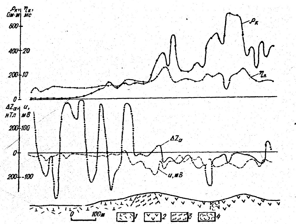
Fig. 2. The result of geophysical observations on one of the profiles in the western part of the site. 1 – basalt covers of Neogene-Quaternary age; 2 – metabasalts; 3 – chlorite shales; 4 - tufoslans
It should be emphasized that the survey revealed IP anomalies with an intensity from 10 to 20 ms and a resistance from 300 to 1400 ohms·m above the contact of metabasalts and marbles (Fig. 3). The presence of the IP anomaly suggests the presence of objects capable of polarizing at the contact of these rocks, among which, first of all, should be sulfides. Verification of these anomalies showed the presence of pyrite, and its content from the periphery to the contacts increases sharply. In addition, a faster decrease in the content of pyrite was noted in marbles from the contact to the periphery than in metabasalts. In general, these results are in good agreement with the data of electrical exploration.
One of the most difficult tasks of geophysical work at this site is the problem of dissecting individual lithological differences within a single complex, which is associated with the leveling of the physical properties of rocks as a result of metamorphism. This task can be solved using a wide range of geophysical methods, accompanied by appropriate geological work (in particular, petrographic and facies analysis, drilling of mapping wells, pits, ditches, etc.).
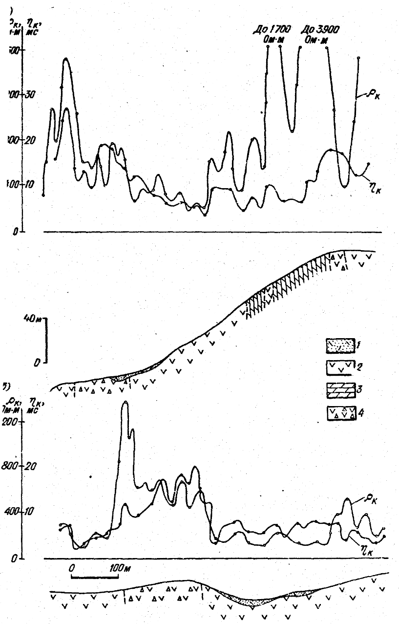
Fig. 3. The results of observations on two profiles of the eastern part of the site: a – profile I; b – profile II
1 – loose sediments; 2 – metabasalts; 3 – marbles; 4 – breccia zone
For a more complete use of the geophysical data, information processing was carried out based on multidimensional static analysis3. The purpose of this analysis was to classify the area under consideration according to complex features into homogeneous areas reflecting the distribution of the main lithological differences. As a rule, this requires an optimal choice of the number of classes representing individual rocks or groups of rocks, which should ensure the representativeness of the most common geological formations that create physical fields different from those of other formations. It should also be borne in mind that the scheme being drawn up should be readable and not contradict existing geological concepts.
From this point of view, it seems more appropriate and optimal to classify fields into two or three classes. An attempt to classify into a larger number of classes has given a complex picture that defies explanation.
So, based on the results of processing, the contours of the main lithological differences have been more or less clearly identified: marbles, metabasalts (including chlorate shales, phyllites) and breccia zones (see Fig. 1, b). At the same time, the breccia zone identified by geophysical data is relatively wider than that recorded on the geological map. Moreover, the marked area cannot be traced to the southern frame of the tablet. Apparently, this is caused by the absence in some cases of a sharp contrast in physical properties between the metabasalts and the breccia zone due to the influence of tectonics. However, despite these differences, the results are similar in many ways.
Conclusions
- IP and resistance methods are the most effective for identifying ore occurrence zones. Magnetic exploration and the EF method are generally of secondary importance and can be used to identify the trenches of individual geological formations.
- In almost all cases, a close correlation between ρk and ηk was noted, with increased ρk and ηk values observed above the breccia zone; in its turn, this highlights the presence of polarizing minerals in a relatively high-ohm environment such as the calcification zone.
- To assess the prospects of the detected ρk and ηk anomalies, it is necessary to conduct detailed geological, geochemical and geophysical studies
1. Yoseph G.S. Preliminary interim report on mineral exploration in Zembe-Belekendu area (western Wollega). Addis Ababa, 1986. P. 49-55
2.
3. Nikitin A.A., Petrov A.V. Classification of complex geofields into homogeneous regions. // Univ. proc. Geology and exploration. 1990. No. 4. pp. 124-125.